Mower County sits along Minnesota’s southern border with Iowa, with Austin anchoring the western side and a noticeably higher belt of hills rising across the east. The Cedar River runs through the Austin area, while branches of the Root River and the Upper Iowa River drain different parts of the eastern county. This page brings those features together with the major towns and roads, and the four matching high-resolution JPG maps can be downloaded in one ZIP after the WebP previews. High-resolution map files are available for download in the section below.
Austin is the simplest orientation point. Interstate 90 crosses the county through Austin and continues east toward Dexter and Grand Meadow, while U.S. 218 runs south from Austin toward Lyle and the Iowa line. Adams, Taopi, and Le Roy occupy the southern and southeastern part of the county, and Brownsdale sits northeast of Austin. Once those places are fixed, the contrast between the lower western terrain and the hillier east becomes much easier to see.
Table of Contents
Austin and the Road Network across the Iowa-Border County
The county overview shows Austin as the largest shaded urban area and the main concentration of roads. I-90 passes through the city and continues east toward Dexter, with Grand Meadow farther along the eastern side. U.S. 218 heads south from Austin toward Lyle, creating a clear north–south reference in the western part of the county. For a first look at Mower County, those two routes provide the fastest way to locate the major settlement pattern.
The central and eastern communities are more dispersed. Dexter lies near the middle, Grand Meadow is farther east, and Elkton sits south of the I-90 corridor. Adams, Taopi, and Le Roy form a separate group toward the south and southeast, with Minnesota 56 visible near the Le Roy side. Racine appears near the eastern boundary, while Sargeant and Brownsdale occupy the northern half. The result is a broad spread of small communities rather than one continuous urban strip.
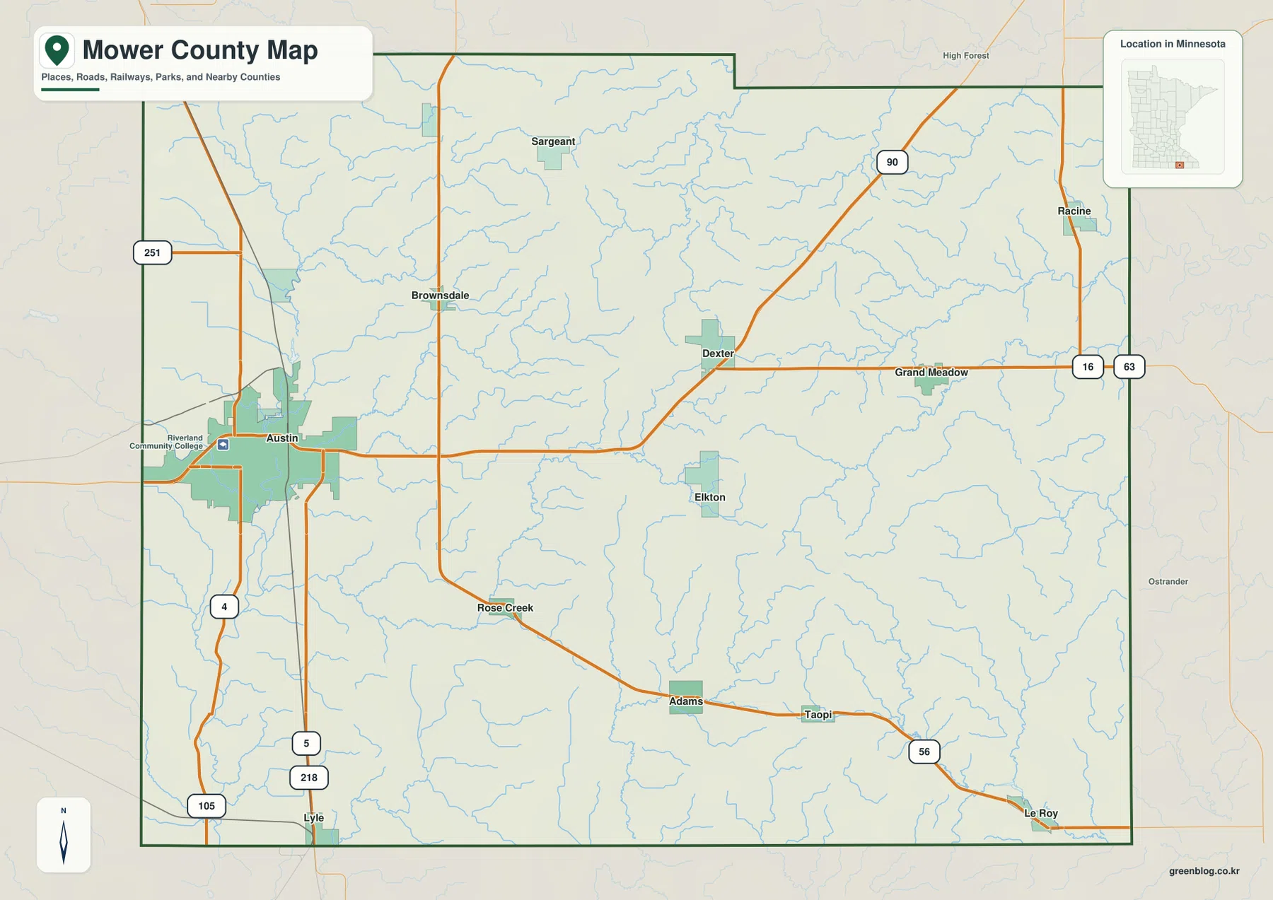
The entire southern edge is the Minnesota–Iowa state line, making Lyle and Le Roy easy to place near the border. Olmsted and Dodge counties are north of Mower County, Fillmore County is east, and Freeborn and Steele counties lie to the west and northwest. The overview is intended for regional orientation; parcel ownership, zoning, and legal boundary questions should be checked with official county mapping or survey records.
Six Major Communities Spread from Austin to Grand Meadow and Le Roy
The ranked city distribution map highlights six communities. Its index lists Austin at 26,358, Grand Meadow at 1,011, Brownsdale at 850, Le Roy at 803, Adams at 745, and Lyle at 504. Austin is much larger than the other entries, but the map is just as useful for showing how far apart the smaller towns are. The index should be treated as the figures supplied with this map, not as a live population table; current official estimates should be verified with the U.S. Census Bureau when needed.
Grand Meadow is in the eastern half, while Brownsdale is northeast of Austin. Le Roy and Lyle are both close to the Iowa line, but they sit on opposite sides of the county and are not part of one compact southern cluster. Adams is inland from the southeastern boundary. This arrangement explains why the city map is useful even though the county overview contains more road detail: the simplified view makes the separation between the six highlighted communities immediately visible.
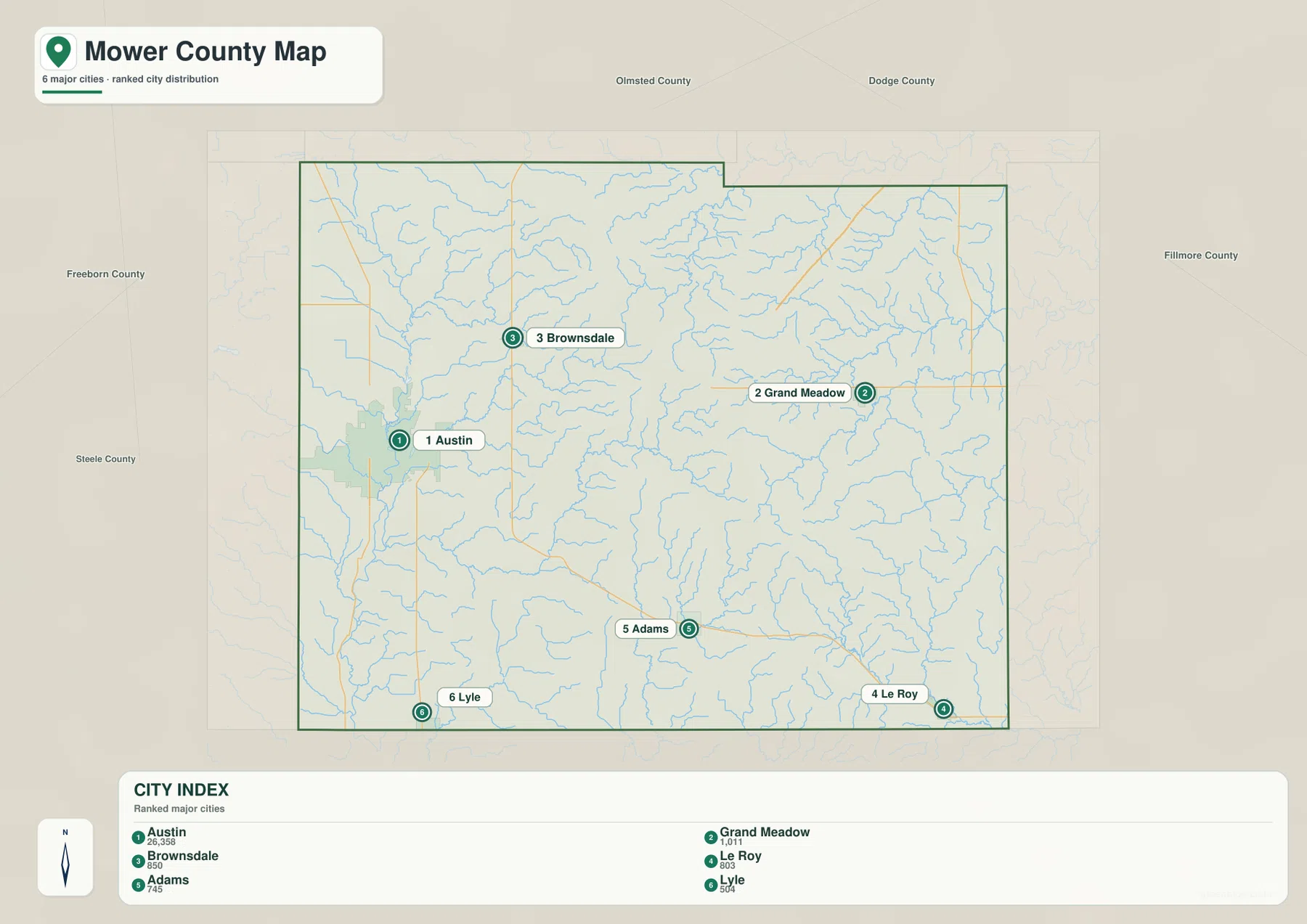
The surrounding county labels add another layer of context. Grand Meadow and Le Roy are close to the Fillmore County side, while Austin and Brownsdale occupy the western half nearer Freeborn and Steele counties. Lyle sits near the southwest corner. For route planning, the ranked city map should be paired with the county overview, where I-90, U.S. 218, Minnesota 56, and the other roads show how those communities are actually connected.
Cedar River Lowlands and the Root–Upper Iowa River Networks
The Cedar River is the strongest water reference in western Mower County. It enters from the northwest and runs south through the Austin area, with Ramsey Mill Pond marked along its course. Wolf Creek and Dobbins Creek approach the Cedar system near Austin, helping explain why the western part of the water map looks like a network feeding one main river. The river continues toward the Iowa border after leaving the city.
Farther east, the drainage becomes more varied. The Little Cedar River runs south through the central county, while the North Branch and South Branch of the Root River appear in the northeast and east. North Fork Bear Creek, South Fork Bear Creek, and Deer Creek occupy the area between those branches. These streams create a different pattern from the Cedar River side, with many narrow valleys cut into the higher eastern ground.
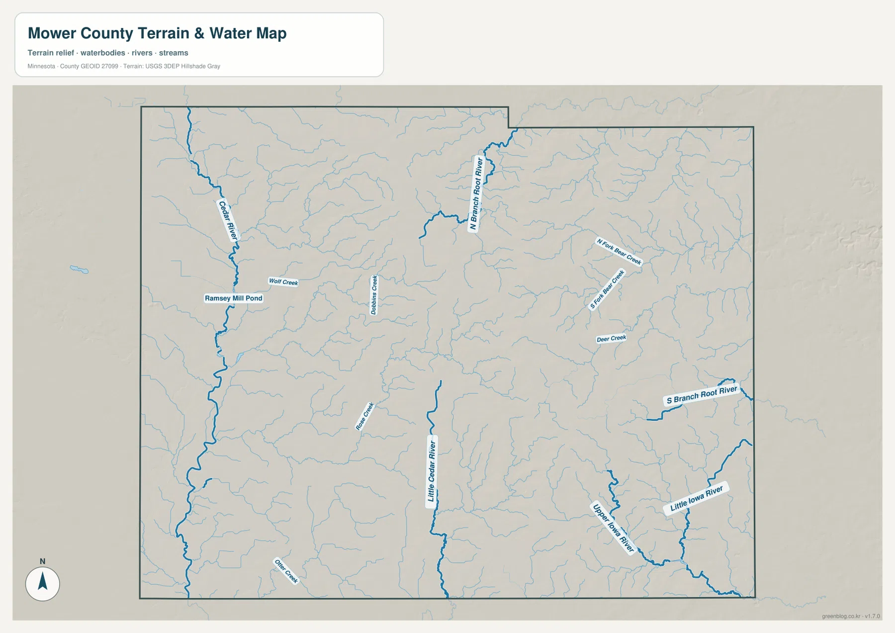
The southeastern corner is associated with the Upper Iowa River and Little Iowa River near the Le Roy side. Their courses are separate from the Cedar River system, so the county cannot be understood as one drainage basin flowing toward a single channel. Rose Creek, Otter Creek, and other smaller streams add still more local detail across the central and southern areas.
Mower County’s official visitor guide notes that the county is one of four in Minnesota without a natural lake, even though water remains important for recreation through the Cedar River and places such as Lake Louise State Park. That description fits the map, where rivers, creeks, and Ramsey Mill Pond stand out more than large natural lakes. The water map is for geographic reference only and does not establish flood risk, depth, navigability, shoreline ownership, or public access.
Lower Western Ground and Higher Ridges toward the East
The elevation map shows a strong west–east contrast. Its legend gives an actual elevation range of about 345 to 438 meters and a mean near 396 meters. Austin and much of the western half are shaded green, indicating lower terrain, while yellows, oranges, and browns become more common across the center and east. The higher ridges east of the county center are among the most obvious terrain features on the page.
Those high areas are not one continuous ridge. The north-central and eastern sections contain many narrow hills separated by lower valleys, and the river and creek channels appear as greener cuts through the relief. Around Grand Meadow and toward Le Roy, the high ground is broken by stream valleys linked to the Root River and Upper Iowa River systems. Comparing the elevation and water maps makes those relationships much clearer.
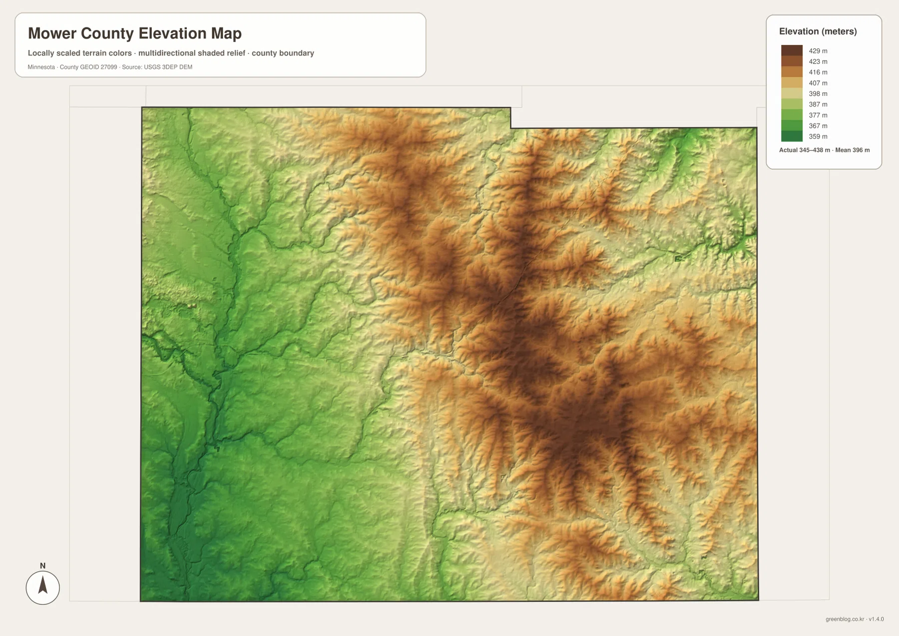
Western Mower County is gentler. The Cedar River follows a low corridor through the Austin side, and broad green areas extend across much of the southwest. Brownsdale and the northwest show some rolling ground, but the relief is less pronounced than the brown ridge country farther east. The county therefore changes from a relatively low western river landscape to a more dissected eastern upland rather than simply rising from south to north.
The colors are scaled to show differences within Mower County and should not be compared directly with the same colors on another county map. The shaded surface is also a generalized terrain visualization rather than survey-grade data. Engineering, drainage design, construction, and legal elevation work require site-specific measurements or higher-precision source data.
Choosing a Map for Roads, Towns, Waterways, or Relief
For roads and town locations, the county overview is the best place to begin. It shows how I-90 passes through Austin and Dexter, how U.S. 218 reaches Lyle, and where Grand Meadow, Adams, Le Roy, and the other communities sit relative to the county boundary. The ranked city map is more useful when the main question is the relative location and scale of the six highlighted population centers.
For rivers and terrain, begin with the Cedar River at Austin and then move east. The Little Cedar River occupies the center, the Root River branches and Bear Creek system spread across the east, and the Upper Iowa River appears near the southeastern edge. The elevation map explains the setting for those streams by showing lower ground in the west and a much more strongly ridged surface to the east.
The WebP images on the page are optimized for quick viewing. The downloadable ZIP contains the four corresponding high-resolution JPG originals, each 3638 by 2572 pixels. Those files are better for printing or zooming into smaller labels such as creek names and road numbers than a browser screenshot, especially when the map will be used in a classroom handout, local reference sheet, or personal project.
A useful way to work through all four maps is to start in Austin, follow I-90 east toward Grand Meadow, and then compare the southern towns of Adams, Le Roy, and Lyle. Next, trace the Cedar River and the eastern river branches on the water map. Finish with the elevation view to see how the low Austin side gives way to the higher, more deeply cut terrain across eastern Mower County.
Frequently Asked Questions
Which map is best for finding Austin, I-90, and U.S. 218?
Start with the county overview. It places Austin, I-90, and U.S. 218 on the same map and also shows the routes toward Dexter, Grand Meadow, and Lyle. If the main goal is comparing the six highlighted cities rather than following roads, the ranked city distribution map provides a cleaner view.
What are the main river systems shown in Mower County?
The Cedar River dominates the western side around Austin, while the Little Cedar River runs through the central county. The east contains the North and South Branches of the Root River, and the Upper Iowa River plus Little Iowa River appear in the southeast. These waterways belong to different drainage areas rather than one single river corridor.
Why is eastern Mower County darker on the elevation map?
The eastern and northeastern parts of the county are generally higher than the Austin side. The legend shows an actual range of about 345–438 meters with a mean near 396 meters. Broad green lowlands surround Austin and the Cedar River, while the east contains more orange and brown ridges cut by narrow stream valleys.
Map File Information
The ZIP contains the original high-resolution JPG versions of the Mower County overview, city distribution, water, and elevation maps.
- File Type: ZIP containing 4 JPG files
Related Maps
Sources and References
- Mower County official website – county government and local information
- Marvelous Mower County Visitor Guide – Cedar River and county recreation context
- U.S. Census Bureau TIGER/Line Shapefiles – county boundary and geographic reference data
- USGS National Hydrography – river and stream reference data
- USGS 3D Elevation Program – elevation reference data
Green Map creates custom-edited map images using open geographic data sources such as geoBoundaries, Natural Earth, OpenStreetMap, and government open data. These maps are edited visual materials, not raw data files, and are provided for education, documents, presentations, and graphic reference.