Murray County in southwestern Minnesota is shaped by two strong geographic contrasts: a high western landscape and a lake-and-stream network that becomes more prominent toward the east. Slayton is the clearest road and settlement reference, while Lake Shetek and Currie define the northeastern lake country and Fulda anchors the southeast. This page connects those places with the Redwood River, Beaver Creek, the Des Moines River system, and the county’s large elevation range. The WebP maps provide quick on-page reference, and the four matching high-resolution JPG originals can be downloaded together in a ZIP. High-resolution map files are available for download in the section below.
A useful way to orient the county is to start at Slayton and follow Minnesota 30. The highway runs west toward Hadley and Lake Wilson and east toward Currie and Dovray, while Minnesota 267 heads south from the Slayton area toward Iona. Fulda sits farther southeast near U.S. 59 and Minnesota 62. Once those road relationships are clear, the separate lake district around Lake Shetek and the higher western terrain make much more sense.
Table of Contents
Slayton Roads Linking Lake Wilson, Currie, Iona, and Fulda
The county overview places Slayton near the middle of the main road network. Minnesota 30 crosses the county through Lake Wilson, Hadley, Slayton, Currie, and the Dovray side, giving readers an easy east–west reference. Iona is south of Slayton on the Minnesota 267 corridor, while Avoca lies southeast and Fulda is farther down near U.S. 59. The communities are spread across several road branches rather than arranged in one continuous urban strip.
The northeastern part of Murray County has a different visual character because Lake Shetek and nearby water features occupy so much space. Currie sits close to the lake’s southwestern side, and the large area labeled The Lakes lies farther north. Dovray is east of Currie along the road leaving the lake area. This lake country is separated from the Slayton and Fulda side by a broad rural interior, which helps explain why the county has more than one practical geographic reference point.
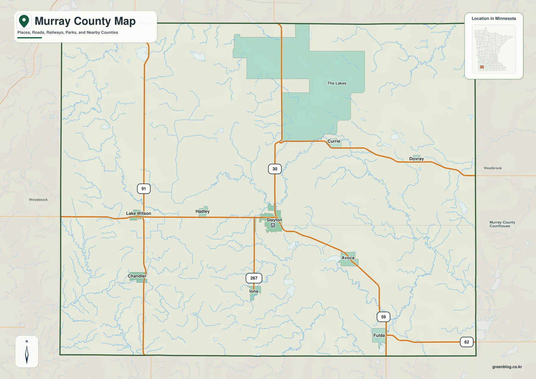
On the west, Lake Wilson and Chandler are aligned around Minnesota 91, with Hadley closer to the central route. The county boundary is mostly broad and rectangular but includes irregular northern sections around the lake district. The overview is intended for roads, towns, and general boundaries; it should not be used to determine parcels, ownership, zoning, or legal survey lines.
Six Communities Spread across the Western, Southern, and Lake Districts
The ranked city distribution map highlights six communities. Its index lists Slayton at 2,141, Fulda at 1,393, Chandler at 331, Lake Wilson at 237, Currie at 220, and Iona at 214. Slayton is the largest entry, but the six places are widely dispersed: Fulda is in the southeast, Chandler and Lake Wilson are west, Currie is northeast, and Iona is south of Slayton. The figures are best treated as the index supplied with the map rather than a substitute for the latest Census population estimates.
That spread is important when reading the county. Slayton works as the central reference for several roads, yet Fulda has its own southeastern position and Currie belongs to the Lake Shetek side of the county. Chandler and Lake Wilson form a western pair, while Iona sits alone farther south. The simplified city map removes much of the road detail, making those relative positions easier to compare at a glance.
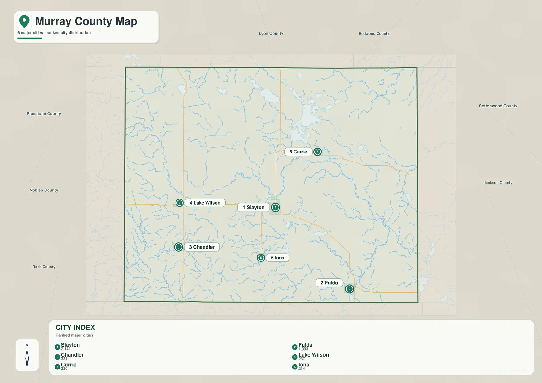
The surrounding counties add useful context. Lyon and Redwood counties lie to the north, Cottonwood and Jackson are to the east, Nobles and Rock are south and southwest, and Pipestone County is on the west. This explains why Lake Wilson and Chandler feel close to the western edge while Fulda occupies a southeastern corner position. For trip planning or road choice, the city map is most useful when paired with the full county overview.
Lake Shetek and the Rivers and Creeks Crossing Murray County
Lake Shetek is the dominant water feature in the northeastern part of Murray County. Lake Sarah, Lake Maria, Bloody Lake, and The Inlet cluster around the larger lake, creating a much denser water landscape than the southern and western parts of the county. Minnesota DNR maintains Lake Shetek State Park on the lake and provides separate information for swimming, fishing, boating, trails, and other recreation.
The rest of the county is organized more by rivers and creeks. The Redwood River appears in the northwest, while Beaver Creek crosses the central area. Farther southeast, Lime Creek and Jack Creek become important local waterways, and the Des Moines River is visible near the eastern edge. These channels help show how water moves away from the higher western terrain into the lower eastern side.
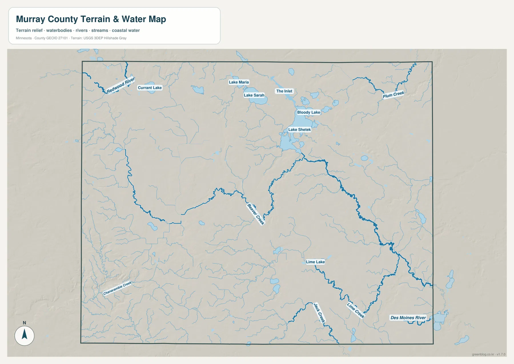
Other landmarks add to the contrast. Chanarambie Creek winds across the southwest, while Lime Lake sits in the southeast. The Lake Shetek group in the northeast is therefore not representative of the entire county; much of Murray County is better described by small streams, shallow drainage corridors, and scattered lakes. Comparing the water map with the road map makes that regional difference especially clear.
This is a geographic water-reference map, not a floodplain, depth, navigation, shoreline-ownership, or legal-access map. Anyone planning to boat, fish, or use public access at Lake Shetek or smaller waters should check current Minnesota DNR and Murray County information rather than relying on the map alone.
High Western Uplands Falling toward the Lower East
The elevation map shows an unusually strong west-to-east contrast. Its legend gives an actual range of about 378 to 586 meters and a mean near 486 meters. Browns and dark oranges dominate the west and southwest, where the county reaches its highest ground, while yellows and greens spread across the central and eastern portions. The overall pattern is clear even before individual ridges and valleys are examined.
The western edge contains long high ridges and rolling uplands, with particularly strong relief in the southwest. Moving toward the center, the surface becomes lower and more moderate, although it still contains small hills and shallow valleys. The Lake Shetek area and much of the eastern county are greener, placing them well below the highest western terrain.
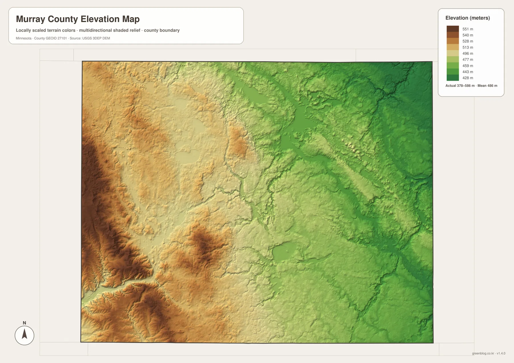
The water map helps explain the lower eastern surface. Beaver Creek, Lime Creek, and the Des Moines River occupy corridors that fit the county’s general fall toward the east and southeast. That does not mean every stream follows one simple slope, but the combination of water and elevation maps makes the large-scale relationship between high western ground and lower eastern drainage much easier to see.
The colors are scaled locally to emphasize differences inside Murray County. A brown or green shade on another county map may represent a different absolute elevation. The shaded relief is also intended for regional interpretation, not engineering, drainage design, construction, or legal surveying, all of which require more precise source data or field measurements.
Choosing the Best Map for Roads, Water, or Relief
For roads and settlements, the county overview is the best starting point. Follow Minnesota 30 across Lake Wilson, Slayton, and Currie, then use Minnesota 91 for the western pair of Lake Wilson and Chandler and U.S. 59 for the Fulda area. The ranked city map is more efficient when the goal is simply to compare the six highlighted communities without as much road detail.
For natural features, begin with Lake Shetek and the nearby lakes before following the Redwood River, Beaver Creek, Lime Creek, and the Des Moines River system. The elevation map then adds the broader setting by showing the sharp drop from the western uplands toward the lower east. Together, the maps explain why the northeastern lake district and the western high ground feel so different despite being part of the same county.
The WebP previews on the page are designed for quick viewing. The downloadable ZIP contains the corresponding high-resolution JPG originals, each 3638 by 2572 pixels, covering the county overview, city distribution, water features, and elevation. Those originals are preferable for printing or for zooming into small road labels and creek names.
A practical way to read Murray County is to begin in Slayton, move northeast to Currie and Lake Shetek, then compare the western towns of Lake Wilson and Chandler with Fulda in the southeast. Finish with the elevation view, and the county’s major geographic pattern becomes clear: high ground in the west, a broad central transition, and lower lake-and-stream country to the east.
Frequently Asked Questions
Which map is best for locating Slayton and Lake Shetek?
Start with the county overview. It places Slayton on Minnesota 30 and shows Currie northeast of it near Lake Shetek. The water map is the better second view when you want to see Lake Sarah, Lake Maria, Bloody Lake, The Inlet, and the other water features surrounding the main lake.
Where is the highest terrain in Murray County?
The elevation map shows the highest ground in the west and southwest. The legend gives an actual county range of about 378–586 meters with a mean near 486 meters. Elevation generally decreases toward the east, where the Lake Shetek and Des Moines River sides are shown in lower green tones.
How are the six highlighted cities distributed?
Slayton is near the center, Fulda is in the southeast, Chandler and Lake Wilson are to the west, Currie is northeast near Lake Shetek, and Iona is south of Slayton. The city distribution map is best for comparing those positions, while the county overview adds the roads connecting them.
Map File Information
The ZIP contains the original high-resolution JPG versions of the Murray County overview, city distribution, water, and elevation maps.
- File Type: ZIP containing 4 JPG files
Related Maps
Sources and References
- Murray County official website – county government and local information
- Minnesota DNR Lake Shetek State Park – Lake Shetek recreation and park information
- U.S. Census Bureau TIGER/Line Shapefiles – county boundary and geographic reference data
- USGS National Hydrography – river, stream, and lake reference data
- USGS 3D Elevation Program – elevation reference data
Green Map creates custom-edited map images using open geographic data sources such as geoBoundaries, Natural Earth, OpenStreetMap, and government open data. These maps are edited visual materials, not raw data files, and are provided for education, documents, presentations, and graphic reference.