Nicollet County has a distinctive shape because the Minnesota River wraps around much of its western, southern, and eastern edge. St. Peter and North Mankato sit close to that river corridor, while Nicollet, Courtland, and Lafayette are spread across the interior and western side. This guide connects the road network with Swan Lake, Seven Mile Creek, the Minnesota River valley, and the higher interior terrain. The WebP previews are designed for quick viewing, and the same four map themes are available as high-resolution JPG originals in a downloadable ZIP.
The easiest way to orient the county is to begin with St. Peter and the Minnesota River. U.S. 169 passes through St. Peter and continues south toward North Mankato, while Minnesota 99 heads west toward Nicollet. Farther inland, Minnesota 22 and Minnesota 111 provide north–south references, and U.S. 14 ties the Courtland side of the county to the New Ulm–Mankato corridor. Once the river boundary and these roads are located, the county’s irregular outline becomes much easier to understand.
Table of Contents
A County Boundary Shaped by the Minnesota River
The county overview is dominated by the winding Minnesota River boundary. The line follows the river from the western side toward Courtland and then bends along the southern edge toward North Mankato. Around St. Peter, the river valley again forms the county’s eastern side. This creates a long, tapered shape rather than a simple rectangle, with a relatively straight northern boundary contrasting sharply with the river-cut edges.
St. Peter is the strongest eastern road reference because U.S. 169 and Minnesota 99 meet there. U.S. 169 continues toward North Mankato and the broader Mankato urban area, while Minnesota 99 runs west toward Nicollet. Lafayette sits farther north near Minnesota 15, and Courtland is southwest along the U.S. 14 corridor toward New Ulm. These roads make the county easier to read as several linked settlement areas rather than one continuous urban strip.
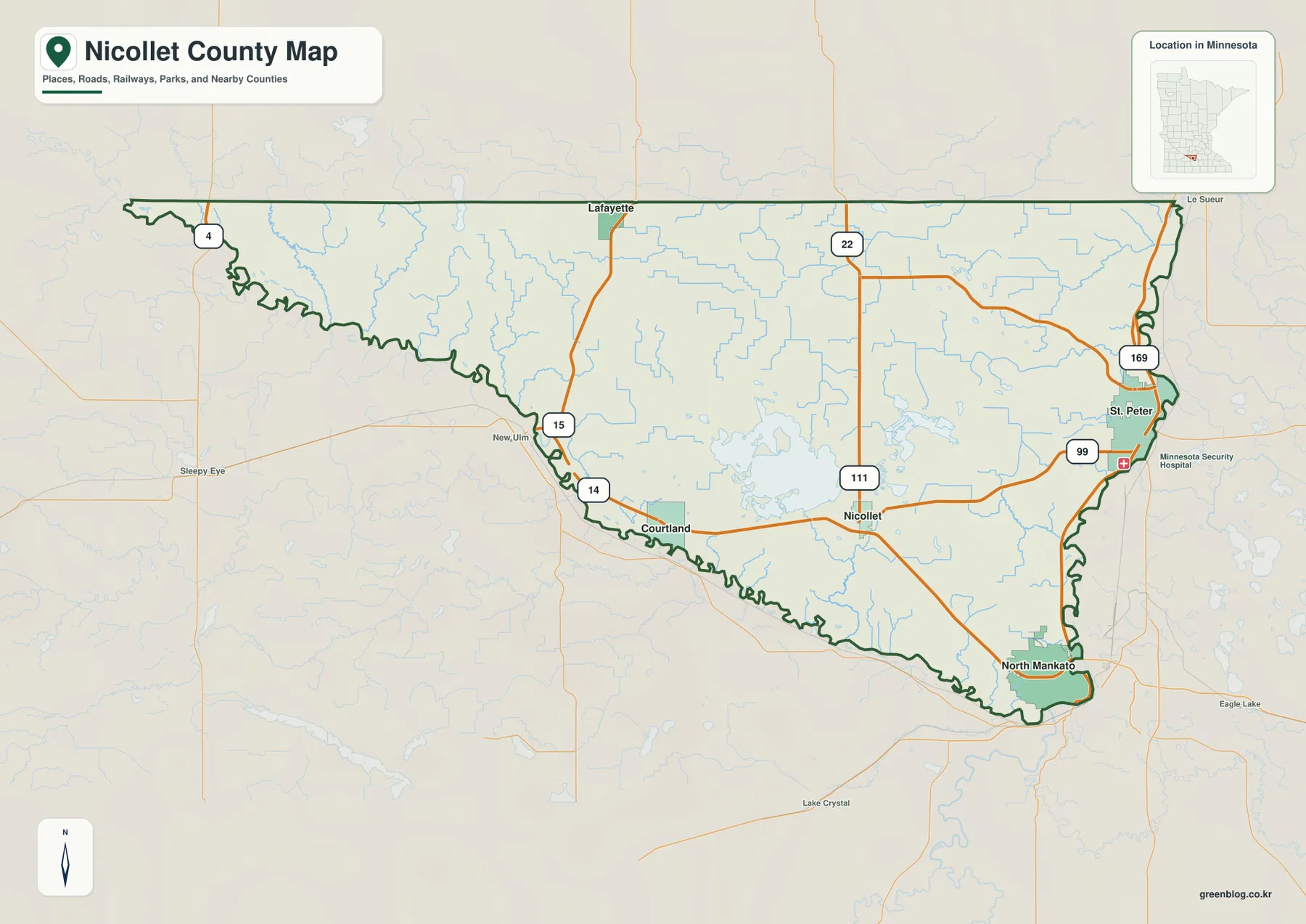
The river bends also make the boundary more complex on the west and southeast. A place can look close to the county edge in straight-line terms while the actual road connection follows a different route around the valley. The overview is useful for general orientation, but parcel ownership, zoning, and legal boundary questions should be checked with Nicollet County’s official mapping and survey resources.
Large River-Corridor Cities and Smaller Interior Communities
The ranked city map highlights five major communities. Its index lists North Mankato at 14,211, St. Peter at 12,185, Nicollet at 957, Courtland at 770, and Lafayette at 484. The two largest entries are concentrated near the river on the eastern and southeastern side, while the smaller communities are distributed across the central, western, and northern parts of the county. These numbers are the values shown on the map and should not be treated as a live population table when a current official estimate is required.
North Mankato occupies the southeastern tip where the county meets the Mankato urban area, while St. Peter is farther north along the Minnesota River. Nicollet sits inland to the west, Courtland is southwest near U.S. 14, and Lafayette is close to the northern boundary. The result is a clear split between larger river-corridor cities and smaller interior communities, something that is easier to see on the simplified city map than on the more detailed road overview.
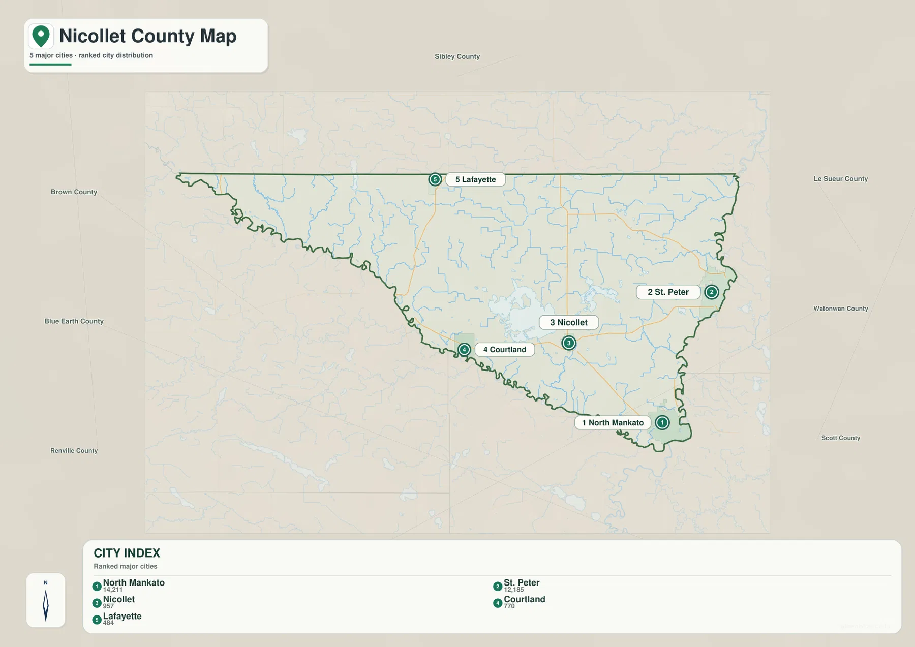
The surrounding county labels add useful context. Brown and Blue Earth counties lie to the west and southwest, Sibley County is north, and Le Sueur County is east. St. Peter and North Mankato are therefore positioned close to different external travel directions than Courtland or Lafayette. For city placement alone, this ranked map is efficient; for the actual highway connections between those places, the full county map provides the necessary road detail.
Swan Lake, Seven Mile Creek, and the Minnesota River Network
The Minnesota River is the main water feature and one of the defining boundaries of Nicollet County. It follows much of the southwest and southern edge and continues along the river valley near St. Peter and North Mankato. Swan Lake is the largest inland water body shown on the map, with South Bay labeled on its lower side. East of Swan Lake, Duck Lake, Wiwi Bay, and Middle Lake form a smaller cluster that gives the central-southern part of the county a much wetter appearance.
Several named creeks connect the interior with the river valley. Seven Mile Creek runs toward the Minnesota River south of St. Peter, while Nicollet Creek crosses the south-central area. Rogers Creek appears on the eastern side, and Little Rock Creek plus Eightmile Creek are labeled farther west. Clear Lake and Sand Lake add smaller northern water landmarks, so the county’s water features are spread across a broad area rather than confined to the main river.
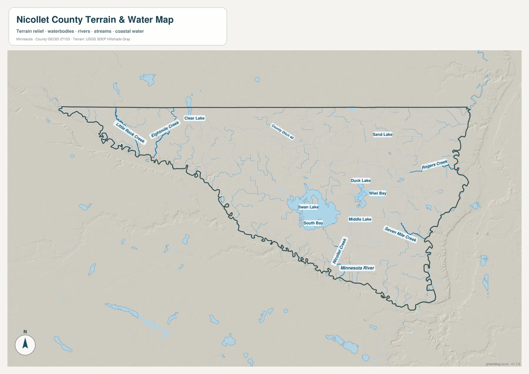
Seven Mile Creek is especially useful for connecting the water and terrain maps. Minnesota DNR identifies Seven Mile Creek County Park south of St. Peter along the Minnesota River corridor, where the creek reaches the river valley. On the supplied maps, the creek follows a lower channel cut into the higher interior surface before reaching the broad river lowland. That relationship is one of the clearest examples of local relief shaping a named waterway.
This water layer is intended for geographic reference, not flood-risk, depth, navigation, shoreline ownership, or public-access decisions. Anyone planning recreation along the Minnesota River, Swan Lake, or Seven Mile Creek should use current Minnesota DNR and local information for access, regulations, and conditions.
Low River Valleys below the Higher Interior Uplands
The elevation map shows a strong contrast between the Minnesota River valley and the county interior. Its legend gives an actual range of about 221 to 323 meters and a mean near 295 meters. Green bands trace much of the river boundary, while orange and brown tones spread across the higher interior. The northwest and central uplands stand well above the river corridor, even though the county does not contain mountainous terrain.
Along the western river bends, the low green strip is often narrow, with elevation rising quickly just inside the county. The same pattern appears around St. Peter and toward North Mankato: the immediate river corridor is low, then the land climbs onto a broader upland surface. This explains why the road map can look relatively flat while the shaded relief reveals clear valley walls and changes in local height.
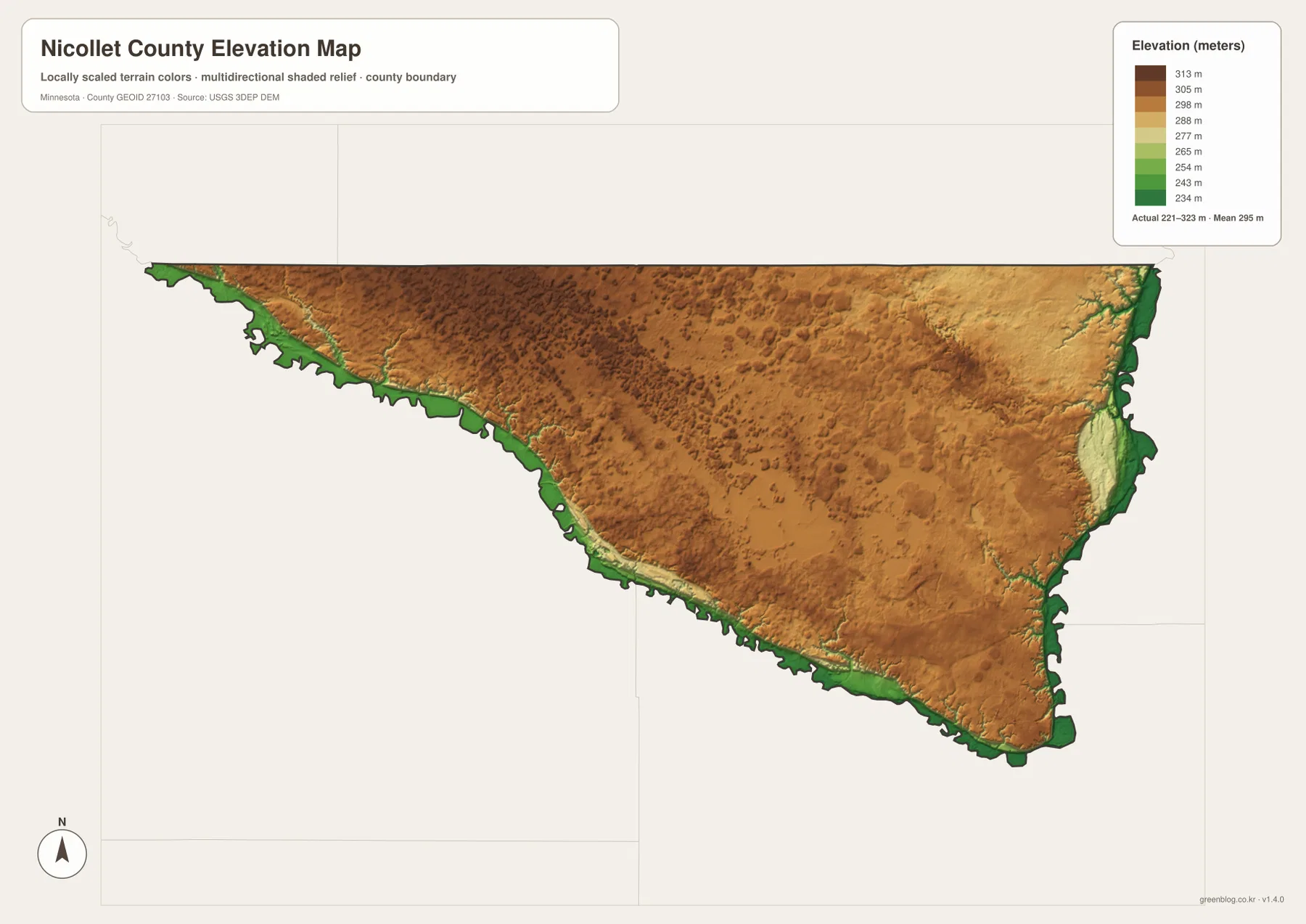
The Swan Lake area is more varied than a single flat basin. Lower wetland and lake terrain is mixed with gently higher land, while Nicollet Creek and Seven Mile Creek occupy narrow depressions leading toward the Minnesota River. Comparing the water map with the elevation map makes those drainage paths easier to understand because the named creeks follow lower routes through the uplands.
The elevation colors are locally scaled to emphasize differences within Nicollet County. A brown or green shade on another county map may represent a different absolute height. The shaded surface is also a generalized geographic product, not a survey-grade measurement, so engineering, construction, drainage design, and legal elevation work require more precise source data or field measurements.
Choosing the Best View for Roads, Water, or Relief
For roads and settlement orientation, the county overview is the best starting point. It shows U.S. 169 through St. Peter, Minnesota 99 toward Nicollet, U.S. 14 near Courtland, and the north–south routes through the interior. The ranked city map is more efficient when the main question is how North Mankato, St. Peter, Nicollet, Courtland, and Lafayette are distributed relative to one another.
For natural geography, begin with the Minnesota River and then compare Swan Lake, Seven Mile Creek, and Nicollet Creek. The elevation map adds the reason those waterways occupy particular corridors: the river is in a broad low valley, while the county interior stands higher. St. Peter is an especially useful comparison point because a major city, highway, tributary valley, and the Minnesota River all occur close together.
The on-page WebP images are optimized for quick viewing. The ZIP contains the corresponding high-resolution JPG originals for the county, city distribution, water, and elevation maps. Each file is 3638 by 2572 pixels, making the originals better for printing or zooming into small road and creek labels than a screenshot of the browser view.
A practical way to understand Nicollet County is to follow the Minnesota River from the St. Peter side toward North Mankato, then move inland to Nicollet, Courtland, and Lafayette. After that, compare Swan Lake and Seven Mile Creek on the water map and finish with the elevation view. The sequence shows how the river boundary, settlement pattern, water network, and upland relief fit together across the same county.
Frequently Asked Questions
Which map is best for locating St. Peter and North Mankato?
Start with the county overview. St. Peter is shown on the eastern side around U.S. 169 and Minnesota 99, while North Mankato is at the southeastern tip near the Minnesota River. The ranked city map is a useful second view when you want to compare both cities with Nicollet, Courtland, and Lafayette.
How does the Minnesota River shape Nicollet County?
The river follows much of the county’s western, southern, and eastern edge, creating a long irregular boundary instead of a simple rectangular outline. The elevation map also shows the river corridor as a lower green zone below the higher interior, so the administrative boundary and the physical valley are closely related.
Where are Swan Lake and Seven Mile Creek on the maps?
Swan Lake is the large inland water body in the central-southern part of the county, while Seven Mile Creek is east of it and runs toward the Minnesota River south of St. Peter. The water map shows their names most clearly, and the elevation map adds the lower channels and surrounding higher ground.
Map File Information
The ZIP contains the original high-resolution JPG versions of the Nicollet County overview, city distribution, water, and elevation maps.
- File Type: ZIP containing 4 JPG files
Related Maps
Sources and References
- Nicollet County official website – county government and local information
- Minnesota DNR Minnesota River segments and maps – river corridor and Seven Mile Creek County Park context
- U.S. Census Bureau TIGER/Line Shapefiles – county boundary and geographic reference data
- USGS National Hydrography – river, stream, and lake reference data
- USGS 3D Elevation Program – elevation reference data
Green Map creates custom-edited map images using open geographic data sources such as geoBoundaries, Natural Earth, OpenStreetMap, and government open data. These maps are edited visual materials, not raw data files, and are provided for education, documents, presentations, and graphic reference.