Kalamazoo County in southwest Michigan is easiest to understand by starting with the paired urban centers of Kalamazoo and Portage. I-94 crosses the county from west to east near the southern side of the central urban area, while US-131 runs north-south along its western edge. Beyond that core, Richland and Gull Lake mark the northeast, Galesburg and the Kalamazoo River help define the east, and Vicksburg and Schoolcraft provide clear reference points in the south. The maps on this page can also be downloaded as A3 high-resolution JPG files in one ZIP for larger viewing or printing. High-resolution map files are available for download in the section below.
The county does not read as a single continuous city. Kalamazoo and Portage occupy a broad central zone, but smaller communities and water features quickly become more useful once you move away from them. Richland sits near the Gull Lake area, Galesburg lies close to the I-94 and Kalamazoo River corridor, and the southern half contains a scattered group of lakes around Portage, Vicksburg, and more rural areas. The elevation view adds another layer by showing a lower central corridor between higher terrain on the western and eastern sides.
Table of Contents
Kalamazoo and Portage create the main urban anchor around I-94 and US-131
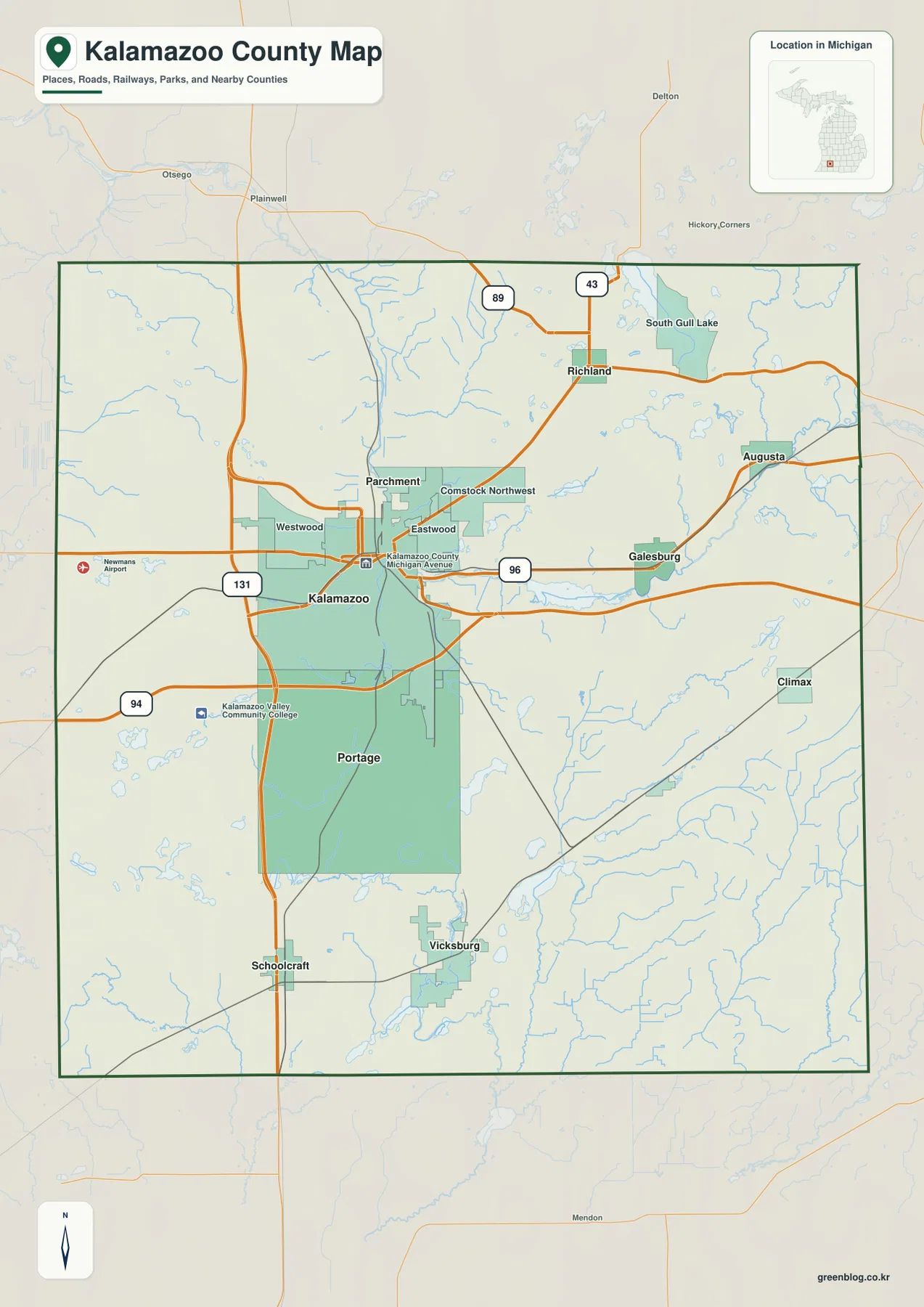
The general county map is dominated by Kalamazoo and Portage. Kalamazoo occupies the central part of the county, and Portage extends immediately south of it, creating the largest continuous built-up area on the map. Parchment is tucked just north of Kalamazoo, while Westwood, Eastwood, and Comstock Northwest sit close to the same central cluster. Starting with this urban area gives you a reliable reference before moving outward to the smaller towns and rural parts of the county.
I-94 and US-131 make that central area even easier to locate. I-94 runs east-west through the county near Kalamazoo and Portage and continues toward Galesburg, while US-131 follows a north-south path just west of the main city centers. In the northeast, state routes around Richland connect the central part of the county with the Gull Lake area. These roads are more useful as orientation lines than the many local streets because they quickly show which side of the county a community occupies.
Galesburg appears east of Kalamazoo near the I-94 corridor, with Augusta farther northeast. Richland is positioned north of the central urban area and southwest of Gull Lake, while South Gull Lake lies beside the large lake itself. In the south, Vicksburg and Schoolcraft are separated rather than forming one continuous center: Vicksburg lies southeast of Portage, and Schoolcraft is farther southwest near the US-131 side. Those relationships are useful for narrowing down a location before reading smaller roads.
The ranked city map shows how sharply the county shifts beyond Kalamazoo and Portage
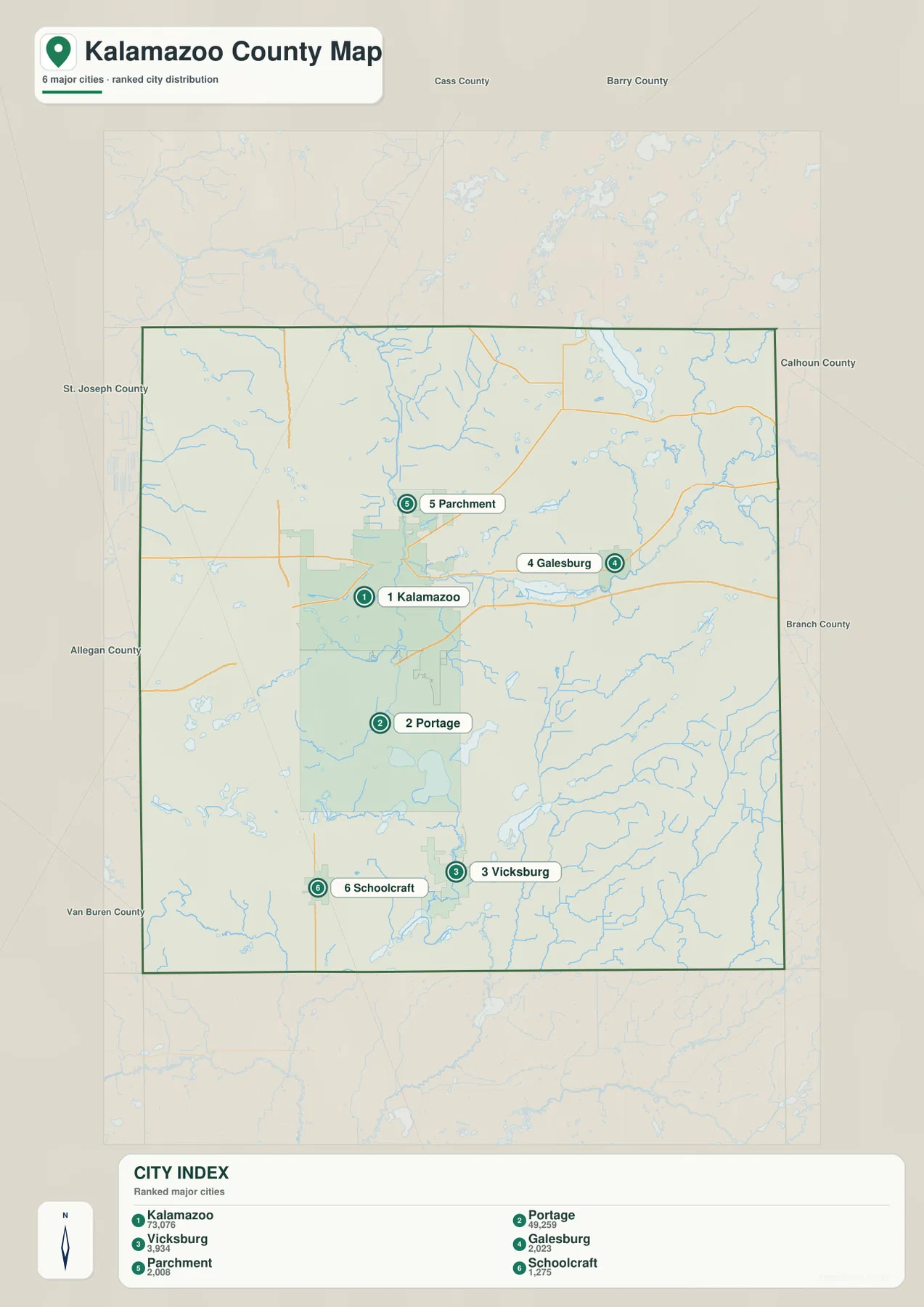
The city distribution map highlights six places: Kalamazoo, Portage, Vicksburg, Galesburg, Parchment, and Schoolcraft. The comparison figures printed on the map are 73,076 for Kalamazoo, 49,259 for Portage, 3,934 for Vicksburg, 2,023 for Galesburg, 2,008 for Parchment, and 1,275 for Schoolcraft. These values are best used as the figures behind the map’s ranking rather than as a current population table; readers who need the latest population estimates should consult an up-to-date Census source.
The more important feature is the spatial separation. Kalamazoo and Portage sit together in the center, while Parchment remains close to Kalamazoo on the north side. Galesburg is distinctly east of the main urban core, Vicksburg occupies the southeast, and Schoolcraft is in the southwest. This arrangement makes the map useful when a city name is known but a road is not, because the city itself immediately points to the correct part of the county.
No connector lines or route distances are drawn between the cities, so the city map is not a mileage or travel-time chart. Its purpose is to show relative placement and ranking. Once a city has been located, the general map provides the nearby road context: Galesburg is associated with the I-94 side of the county, Schoolcraft with the US-131 corridor, and Vicksburg with the lake-rich southeastern area. Used together, the two maps make both city position and access routes easier to understand.
Gull Lake and the Kalamazoo River divide the northeast lake country from the eastern river corridor
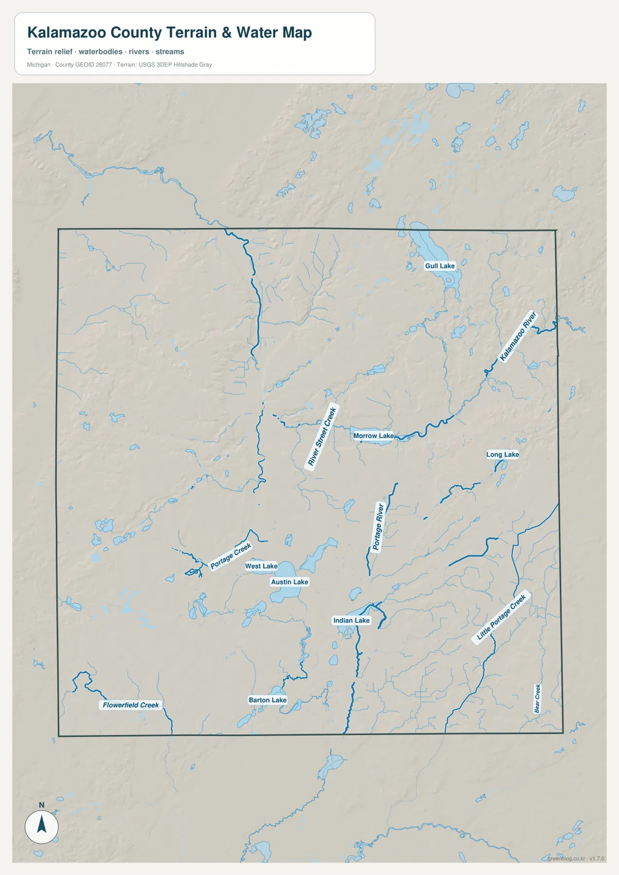
Water features provide some of the clearest landmarks outside the central cities. Gull Lake is the large, easily recognized lake in the northeast, close to the Richland and South Gull Lake area. The Kalamazoo River lies farther east and curves through the county before broadening around Morrow Lake. Because these two major features are separated, they create distinct geographic reference zones: Gull Lake for the northeast and the Kalamazoo River–Morrow Lake corridor for the east.
The eastern river landscape also includes smaller named waterways. River Street Creek appears west of Morrow Lake, and the Portage River runs through the south-central to southeastern part of the county. These channels help explain some of the lower corridors visible on the elevation map. For rural locations, a creek or river name can sometimes be more useful than a city name, especially when the nearest settlement is several miles away.
South of Portage, the map becomes a patchwork of separate lakes rather than one large water body. West Lake and Austin Lake are relatively close to each other, Indian Lake is farther south, and Barton Lake lies still farther toward the southern edge. Long Lake is positioned to the southeast. These names matter because saying that a place is in the “southern lake area” is too broad; a location near Austin Lake is in a different part of the county from one near Barton Lake or Long Lake.
Flowerfield Creek, Portage Creek, and Little Portage Creek add detail to the southern and western parts of the water map. The map is intended for geographic reference, not for flood-risk decisions, navigation, water-depth estimates, fishing regulations, or property-access questions. Those uses require current information from the appropriate agencies. For ordinary orientation, however, pairing the named water bodies with the road map is an effective way to narrow a location to a much smaller part of Kalamazoo County.
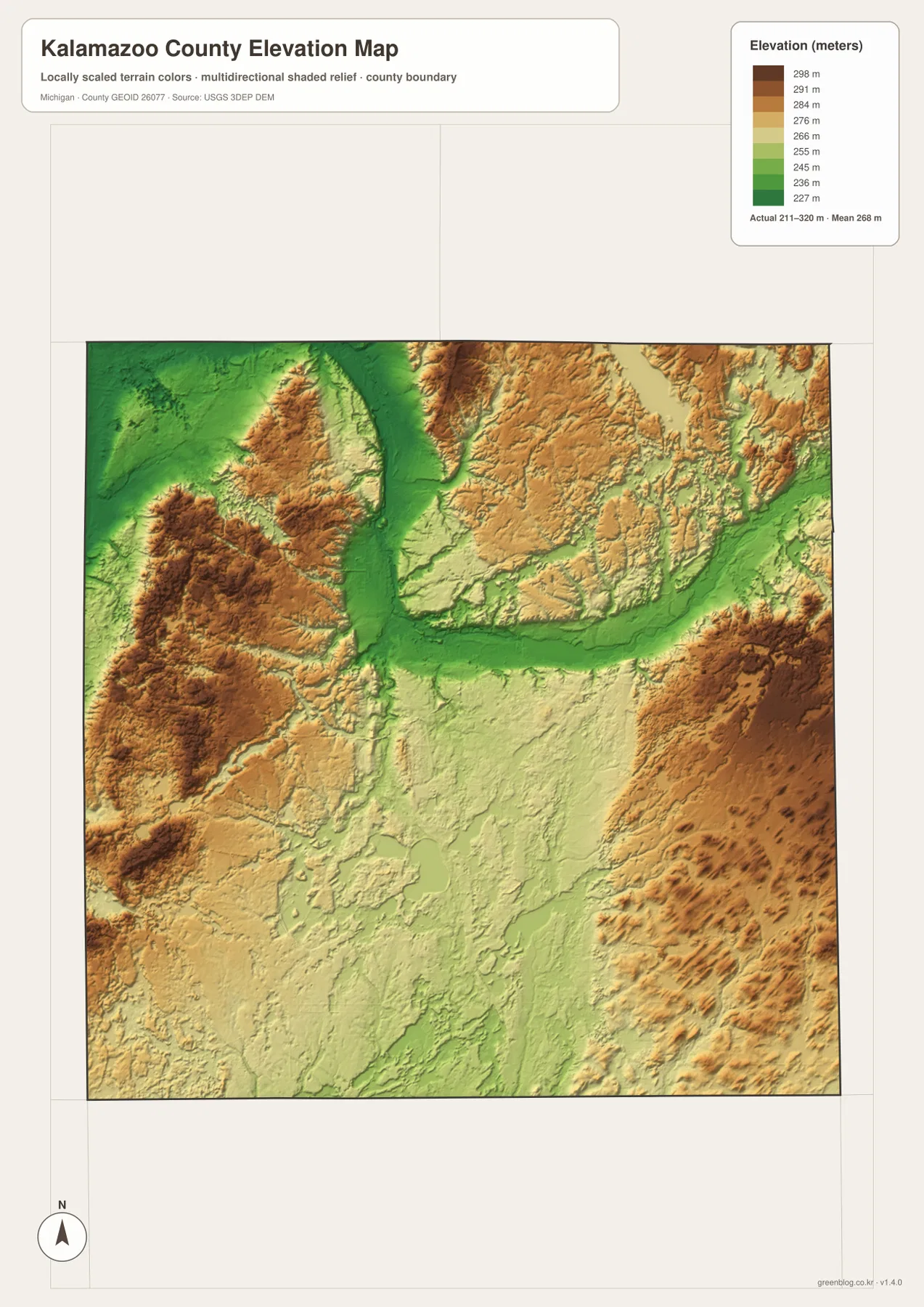
Relief from about 211 to 320 meters reveals a low central corridor between higher outer terrain
The elevation map shows an actual displayed range of about 211 to 320 meters, with a mean near 268 meters. Lower terrain is shown in green, while yellow, tan, and brown represent progressively higher ground. A broad green corridor runs through the north-central and central-eastern part of the county and connects visually with the lower Kalamazoo River area. That low corridor is one of the strongest terrain features on the map and contrasts with the higher ground on both sides.
Western Kalamazoo County contains extensive uplands, including darker brown areas in the west-central section and additional ridges toward the northwest and southwest. The eastern side also rises into broad higher terrain near the county boundary. This means the county is not simply “high in the west and low in the east.” A more accurate county-scale description is a lower central passage bordered by higher terrain toward the outer western and eastern sides.
The southern lake district contains a finer mix of low areas and gentle uplands. Around West Lake and Austin Lake, the colors shift between pale green, yellow, and tan, while narrow low corridors follow some of the streams farther south. Comparing the elevation and water maps is especially helpful here because many lakes and channels occupy the lower parts of the landscape, with modest ridges rising around them. The result is more varied than the flat appearance of a simple boundary map might suggest.
This elevation map is a generalized county-scale surface rather than a survey. The 211- and 320-meter values describe the overall displayed range, not the measured elevation of a particular building, road, or parcel corner. Construction, drainage design, precise slope calculations, and other engineering uses should rely on original USGS data or professional surveying. For general map reading, the color contrast is well suited to comparing the central lowland with the higher western and eastern ridges.
Choose the map by the clue you already have: road, city, water name, or terrain
If you already know a city or highway name, begin with the general county map. Kalamazoo and Portage provide the central anchor, I-94 gives an east-west reference, and US-131 provides a north-south reference on the western side of the urban area. From there, Richland, Galesburg, Vicksburg, and Schoolcraft quickly narrow the search to a smaller zone. The ranked city map is useful when the city name is known but the surrounding roads are not yet important.
If the clue is a lake, river, or creek, the water map is the better starting point. Gull Lake identifies the northeast, the Kalamazoo River and Morrow Lake identify the east, and the group of West Lake, Austin Lake, Indian Lake, Barton Lake, and Long Lake breaks the southern half into several distinct areas. After finding the water body, return to the road map to locate the nearest city and major route. This two-step approach works particularly well for rural addresses and recreation areas.
The elevation map is most useful after the location has already been narrowed down. It shows whether the surrounding area belongs to the central low corridor or one of the higher outer uplands. The body images are optimized for web viewing, while the ZIP download contains four A3 high-resolution JPG files: the general county map, city map, water map, and elevation map. The larger files are better for zooming in on labels or printing a reference copy.
Frequently Asked Questions
What is the easiest way to locate Kalamazoo and Portage on the county map?
Start near the center of the county with Kalamazoo, then look immediately south for Portage. I-94 crosses the southern side of the central urban area from west to east, while US-131 runs north-south along the western side. Parchment is just north of Kalamazoo, and Vicksburg and Schoolcraft are farther south.
Are Gull Lake and the Kalamazoo River in the same part of the county?
No. Gull Lake is in the northeast near Richland and South Gull Lake, while the Kalamazoo River runs through the eastern part of the county and connects with Morrow Lake. Treating them as separate reference areas makes it easier to distinguish the northeast lake country from the eastern river corridor.
How should the 211–320 meter elevation map be used?
Use it to compare broad areas of lower and higher terrain across the county. The central and central-eastern green corridor is lower, while higher tan and brown uplands appear across much of the west and near the eastern edge. It is not survey-grade data, so precise construction or engineering decisions should use authoritative elevation data or professional surveying.
Map File Information
Download the map files associated with this page for reference, printing, and compatible visual projects.
- Included Files: Use only the versions confirmed in the article and supplied images
- File Type: Use the confirmed download contents
- Intended Use: Printing, education, presentations, and map-based projects
Related Maps
Sources and references
The following official sources provide additional county information and authoritative boundary, hydrography, and elevation data. The maps on this page are designed for county-scale orientation and downloadable reference use. Legal boundaries, flood conditions, engineering elevations, and other precision decisions should always be checked against the latest source data from the responsible agency.
- Kalamazoo County, Michigan official website – county services, local information, parks, and GIS resources
- Kalamazoo County: About the County – official county overview and local-government context
- U.S. Census Bureau TIGER/Line Shapefiles – county boundary and geographic data
- USGS National Hydrography – rivers, streams, lakes, and hydrographic data
- USGS 3D Elevation Program – elevation data
Green Map creates custom-edited map images using open geographic data sources such as geoBoundaries, Natural Earth, OpenStreetMap, and government open data. These maps are edited visual materials, not raw data files, and are provided for education, documents, presentations, and graphic reference.