Alger County occupies a long stretch of Michigan’s Upper Peninsula along Lake Superior. Munising sits near the western half of the county’s shore, while Grand Marais marks the far eastern end. M-28 approaches Munising from the west, M-94 crosses the interior, and M-77 runs north toward Grand Marais; M-41 and M-67 become the main road references in the southwest. Roads alone do not define the county, because bays, inland lakes, river valleys, and higher interior ground shape nearly every part of the map.
The page includes a general county map, a ranked city-distribution map, a terrain-and-water map, and an elevation map. High-resolution JPG copies of the four supplied maps are packaged together in the downloadable ZIP. The general map keeps roads and named places together, the city graphic isolates Munising and Chatham, the water map labels the major rivers and lakes, and the elevation view separates low shoreline ground from higher inland terrain.
Munising forms the main coastal reference where M-28 and M-94 meet a deeply indented Lake Superior shoreline. Chatham lies southwest of that coastal area, and the county then extends far east toward Grand Marais through a landscape with fewer settlement labels. Comparing the water and elevation views shows why the map changes so much from one end to the other: rivers occupy lower valleys, while broad uplands rise behind many sections of the shore.
Table of Contents
M-28 at Munising and M-77 toward Grand Marais
Lake Superior dominates the northern edge of the general map. The county boundary bends around bays, projecting land, and offshore islands instead of following a single straight line, especially near Munising. That shoreline shape quickly identifies the county on the page. Munising lies close to the water near the center-west, with M-28 entering from the west and M-94 turning through the interior south and east of town.
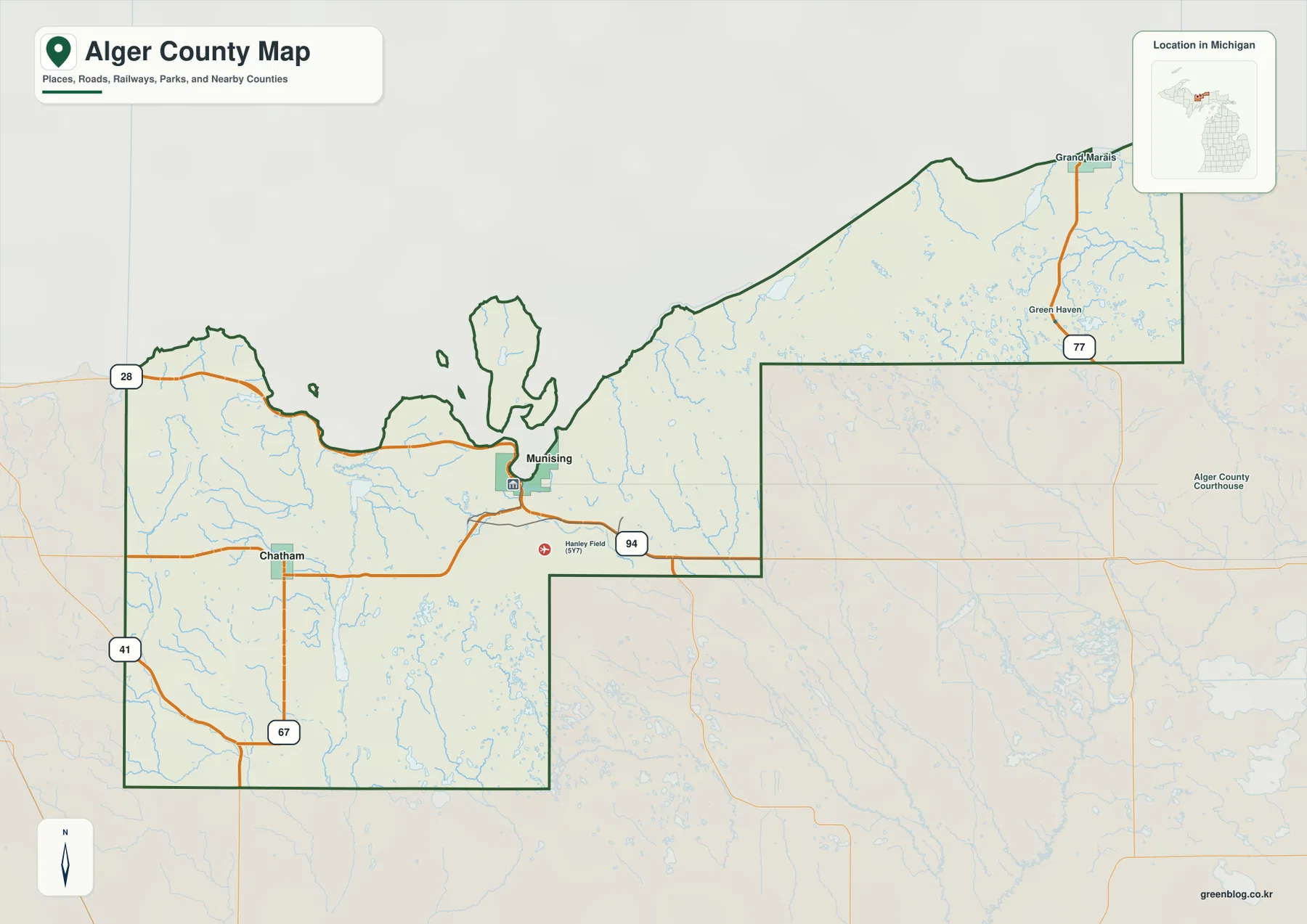
Southwest of Munising, Chatham appears where local roads meet the M-94 corridor. M-41 and M-67 become the main labeled routes toward the western and southern edges. The road network is widely spaced compared with a metropolitan county, so M-28, M-94, M-77, M-41, and M-67 provide the clearest framework for placing smaller roads and communities.
The eastern section of Alger County is long and narrow. M-77 runs north toward Grand Marais, with Green Haven labeled along the route. Grand Marais sits directly beside Lake Superior and marks the eastern end of the county’s main coastal settlement pattern. Between Munising and Grand Marais, the shoreline bends around headlands and bays while the interior rises and falls through valleys and higher ground.
Near Munising, the map also labels Hanley Field, and M-94 continues through the central interior. Those details matter because large parts of Alger County contain few prominent settlement labels. Following the state routes shows where the county remains connected across those open areas and how the eastern extension relates to the central and western sections.
Marquette, Delta, Schoolcraft, Luce, and Mackinac counties are labeled outside the Alger County boundary. Those names place Alger within the Upper Peninsula, while the darker county line separates the subject area from neighboring jurisdictions. The map is intended for general geographic reference, not parcel ownership, legal boundary determination, or live navigation; those tasks require current official records and transportation information.
The Lake Superior shore does not have the same road relationship everywhere. Around Munising, roads and place labels cluster close to a complex bay shoreline. Farther east, the gap between the coast and the main inland routes becomes more noticeable in places. The terrain-and-water and elevation maps show the reason: valleys cut into the interior and higher ground rises behind many shoreline sections, so the county is not a flat coastal strip.
Munising on the shore and Chatham in the southwest interior
The city-distribution map removes most road detail and keeps only two ranked places: Munising and Chatham. Munising is marked first beside the Lake Superior shore, and Chatham is second in the southwestern interior. With the smaller labels stripped away, the map makes the coastal-versus-inland placement of those two communities immediately visible.
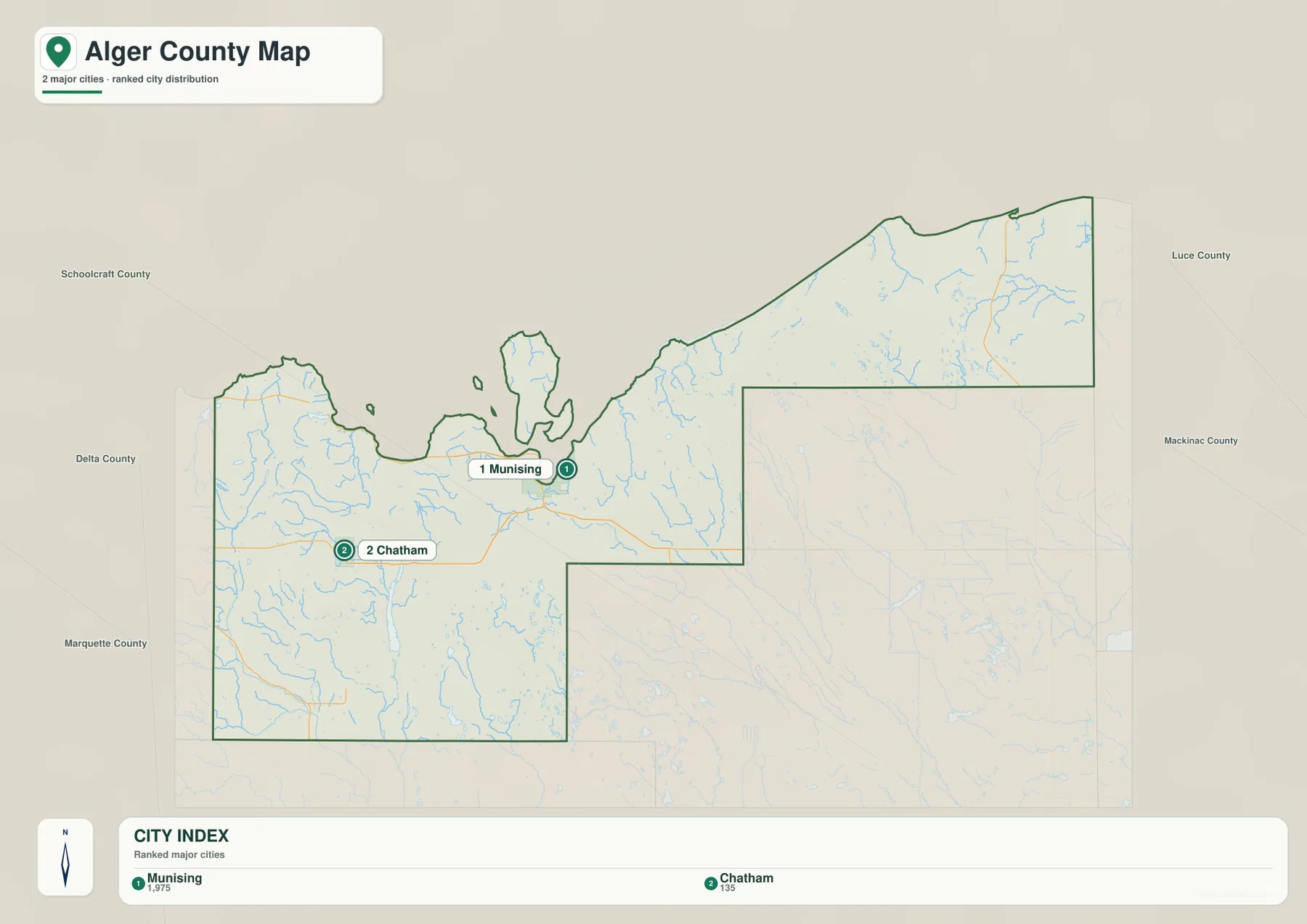
The CITY INDEX lists 1,975 for Munising and 135 for Chatham. Treat those numbers as values attached to the map’s source dataset rather than as guaranteed current population counts, because official totals and estimates change by year and method. The main point of this graphic is location: Munising and Chatham occupy distinctly different parts of the county.
Munising sits near M-28 and M-94 on the coast, whereas Chatham anchors the southwest interior. Their separation shows that Alger County is not a continuous chain of communities along Lake Superior. Roads must connect inland settlements with the shore and with neighboring counties, and the two ranked points make that contrast visible without the clutter of the full road map.
Grand Marais does not appear as one of the two ranked points even though it is shown on the general county map. The city-distribution graphic is therefore a selective summary rather than a complete list of Alger County communities. Use the general map when Grand Marais, M-77, or smaller labels matter; use the ranked city view when the comparison is limited to Munising and Chatham.
The surrounding labels—Schoolcraft, Delta, Marquette, Luce, and Mackinac—show where Alger County sits among its neighbors. The city graphic does not describe those counties in detail. A project that crosses county lines should return to the general map or use separate county maps for the adjoining areas.
Because no route distances or travel times are shown, the spacing between Munising and Chatham should not be converted directly into a driving estimate. Forests, lakes, wetlands, terrain, and the actual road network all affect travel. The city map works best as a location diagram, while current navigation tools should be used for turn-by-turn travel, closures, and seasonal road conditions.
Grand Sable Lake, Au Train River, and a dense network of inland water
The terrain-and-water map shifts attention away from highways and toward Lake Superior, inland lakes, rivers, and shaded relief. Grand Sable Lake stands out near the northeastern shore. Farther southeast are Sucker River and Nawaka Lake, while Miners River is labeled closer to the central Lake Superior coast. In the western half, Au Train River and Au Train Lake form another prominent pair. Together these features show that Alger County contains several distinct water systems rather than one dominant river basin visible at a glance.
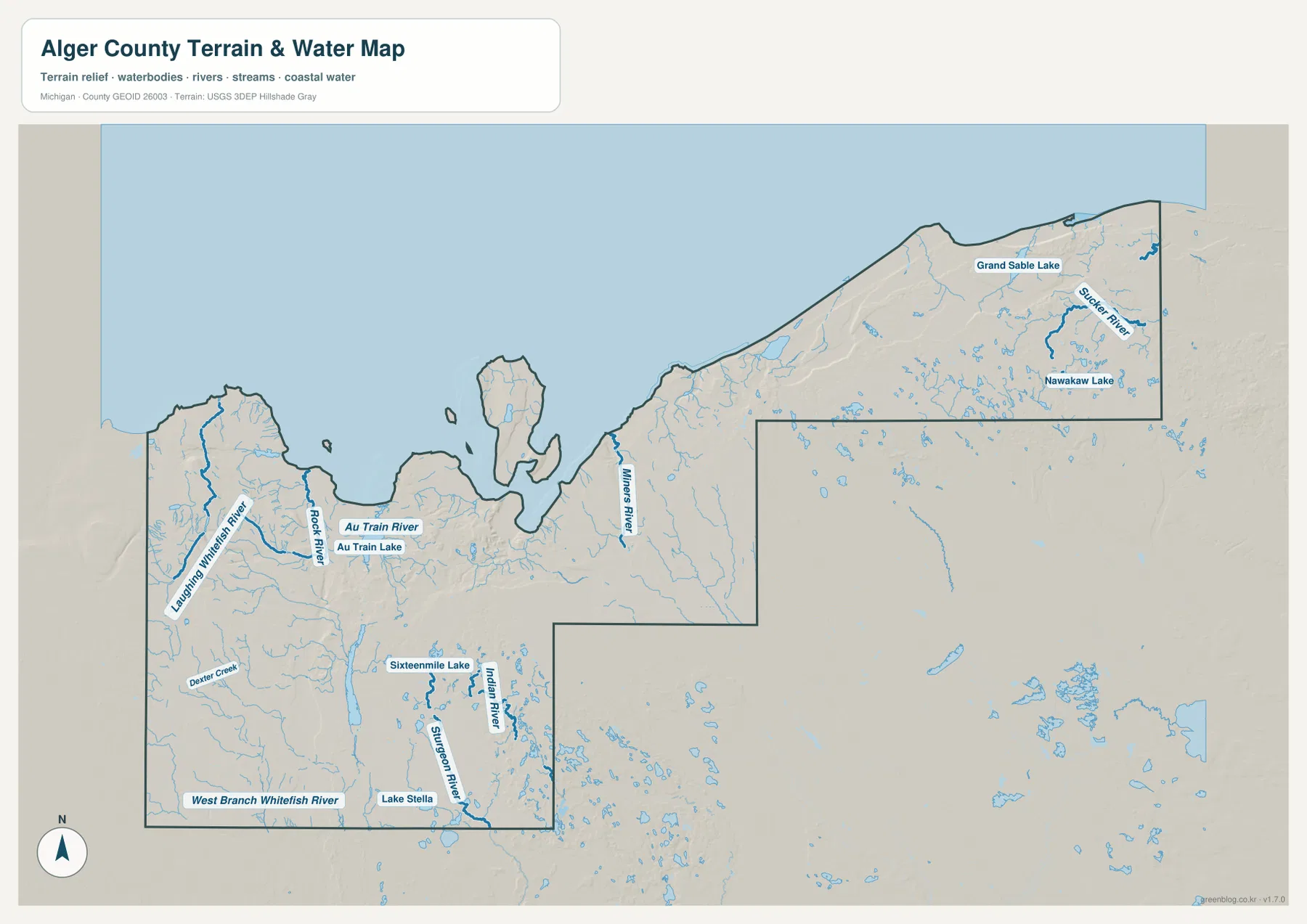
In the west, Laughing Whitefish River and Rock River are labeled with smaller tributaries branching through the surrounding terrain. Dexter Creek and West Branch Whitefish River appear farther south. Blue lines and water bodies stand out more strongly here than on the road map, and the shaded background shows many streams occupying lower ground between nearby hills.
Au Train Lake is one of the larger inland lakes in the western half of the county, with Au Train River continuing toward Lake Superior. The water map isolates that lake-river relationship from the roads and place labels that compete for attention on the general map. Relief shading around the lake also shows uneven ground rather than a broad flat plain.
The southern portion contains another concentration of named waters, including Sixteenmile Lake, Indian River, Sturgeon River, and Lake Stella. This area lies well away from the broad Lake Superior shoreline at the top of the map, so inland lakes and streams become the main geographic references. Numerous smaller blue features reinforce how water is distributed through the county’s interior.
Grand Sable Lake and Nawaka Lake mark the eastern side, while Sucker River crosses the northeastern section. Shaded relief places those waters beside visibly higher and lower ground. The map shows where the features sit, but it does not provide depth, discharge, water quality, flood zones, boating channels, or legal access information.
Lake Superior fills the broad northern side of the map and ties the entire county together geographically. Rivers from different parts of Alger County ultimately relate to that larger coastal setting, but their local courses are varied. For fishing, boating, flood preparation, or water-safety decisions, use the appropriate agency maps and regulations rather than treating this image as a navigation or hazard product.
The Munising and Grand Sable portions of the shore are associated with Pictured Rocks National Lakeshore. This county map is not a park-boundary or trail map; the National Park Service page for Pictured Rocks supplies the current park maps, notices, and visitor information needed for recreation along that Lake Superior coast.
Lake Superior lowlands against Alger County’s higher interior
The elevation map removes most labels and uses locally scaled colors and shaded relief to show height differences. Its legend states an actual data range of about 183 to 350 meters with a mean of 262 meters, while the visible color steps run roughly from 189 to 319 meters. Greens represent relatively lower ground, and yellow-to-brown tones represent higher terrain. The pattern immediately separates many Lake Superior shore and river corridors from the higher interior.
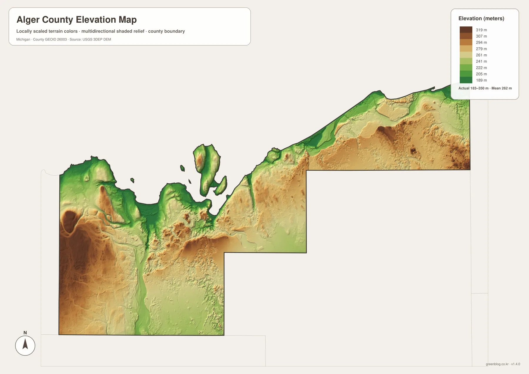
A narrow lower band appears along many parts of the Lake Superior shoreline. Around Munising and the western bays, green areas extend inland along low corridors before giving way to higher colors. That transition is important because it shows that the county’s northern side is not uniformly flat. In several places the terrain rises fairly quickly behind the shoreline, producing a strong contrast over a relatively short distance.
The southwestern interior contains a large area of higher brown and tan terrain broken by lower valleys. When compared with the general map, this is the part of the county associated with the Chatham side and the routes extending toward M-41 and M-67. The image is not detailed enough to assign an exact elevation to a specific road segment, but it clearly shows that the inland southwest has more pronounced relief than many shoreline areas.
The long eastern section also contains broad uplands. Green remains common near the coast and in some drainage corridors, while yellow and brown spread across the interior south of Lake Superior. Near Grand Sable Lake and Sucker River, lower ground beside the water gives way to higher land nearby. Placing the elevation and water maps side by side shows how lakes and river valleys occupy lower corridors within the surrounding uplands.
Many valleys appear as elongated green paths through higher colors. After locating Au Train River, Miners River, and the western river systems on the water map, the same lower corridors can be traced on the elevation view. This comparison describes broad terrain relationships; it should not be used to calculate engineering slopes, flood elevations, or precise cross sections.
The color ramp is scaled for Alger County, so the same shade on another county’s elevation map may represent a different absolute height. Cross-county comparisons should use the numerical legend or the underlying elevation data rather than color alone. For surveying, construction, drainage design, detailed hiking profiles, or other tasks that depend on exact elevations, consult USGS 3D Elevation Program data or another appropriate authoritative source.
In a classroom or presentation, the general and elevation maps can be paired in sequence. First locate Munising and Grand Marais along the shore and Chatham in the southwest, then compare those positions with the low green coastal bands and the higher inland colors. Adding the water map shows where river valleys and lakes cut through those changes in relief.
Choosing between Alger County roads, waterways, and elevation
Start with the general county map when the question involves Munising, Chatham, Grand Marais, or the main state highways. M-28, M-94, M-77, M-41, and M-67 appear with the named places in one image, so the road relationships are visible without switching between graphics. Current closures, driving times, and turn-by-turn directions still belong to live transportation or navigation sources.
The city-distribution map serves a narrower purpose: it compares Munising with Chatham without most minor labels. That stripped-down view makes the coastal location of Munising and the inland position of Chatham obvious. When Grand Marais, M-77, or smaller communities are part of the question, return to the general county map.
For Grand Sable Lake, Au Train River, Miners River, Laughing Whitefish River, Sixteenmile Lake, and the county’s smaller waters, use the terrain-and-water map. Its blue waterways are paired with shaded relief, so stream valleys and nearby hills appear together. Flood risk, water depth, navigation, and regulatory boundaries require separate agency products.
The elevation map is the right view for comparing the Lake Superior edge with the higher southwestern and eastern interior. Greens mark lower ground and many valley floors, while yellow and brown cover higher terrain. Because the image is a generalized county-scale surface rather than a survey, exact site elevations should come from the underlying official data.
WebP images appear in the article for on-screen viewing, and the downloadable ZIP contains the original high-resolution JPG files for printing or larger displays. The road, city, water, and elevation views separate different layers of Alger County so a reader can choose the image that matches the feature being discussed.
Frequently Asked Questions
Which map shows Munising, Grand Marais, and the main state highways together?
Use the general county map. It places Munising with M-28 and M-94, Grand Marais with M-77, and the southwestern routes M-41 and M-67 in the same image. For current driving directions, closures, and travel times, check an up-to-date transportation or navigation source.
Where are Grand Sable Lake and Au Train River easiest to locate?
The terrain-and-water map labels both features and also shows Miners River, Sucker River, Laughing Whitefish River, Sixteenmile Lake, and many smaller inland waters. It is not a flood, depth, water-quality, or navigation map, so specialized decisions require current agency data.
What does the 183–350 meter elevation range mean?
The elevation map states an actual data range of roughly 183 to 350 meters and a mean of 262 meters. Lower Lake Superior shore areas and river corridors generally appear in green, while higher interior hills shift toward yellow and brown. The colors show broad county-scale differences rather than precise site elevations for surveying or engineering.
Map File Information
The ZIP contains the original high-resolution JPG files for the Alger County general map, major-city distribution map, terrain-and-water map, and elevation map described on this page.
- Included Files: General county map, major-city distribution map, terrain-and-water map, elevation map
- File Type: JPG
Related Maps
Sources and References
The following official sources support the boundary, hydrography, elevation, and Pictured Rocks references used in this article.
- U.S. Census Bureau TIGER/Line Shapefiles
- USGS National Hydrography
- USGS 3D Elevation Program
- National Park Service – Pictured Rocks National Lakeshore
Green Map creates custom-edited map images using open geographic data sources such as geoBoundaries, Natural Earth, OpenStreetMap, and government open data. These maps are edited visual materials, not raw data files, and are provided for education, documents, presentations, and graphic reference.