Prince George’s County wraps around the eastern and southern sides of Washington, D.C., stretching from Laurel in the north through College Park, Greenbelt, New Carrollton, and Bowie to Upper Marlboro and a much less densely developed southern interior. Hyattsville, Bladensburg, Cheverly, District Heights, and Forest Heights sit closer to the Washington edge, while the Patuxent and Potomac river systems frame very different parts of the county. This page explains the major settlements, highways, waterways, lakes, and elevation contrasts shown on the supplied maps. Matching high-resolution JPG files are also available together in a downloadable ZIP archive.
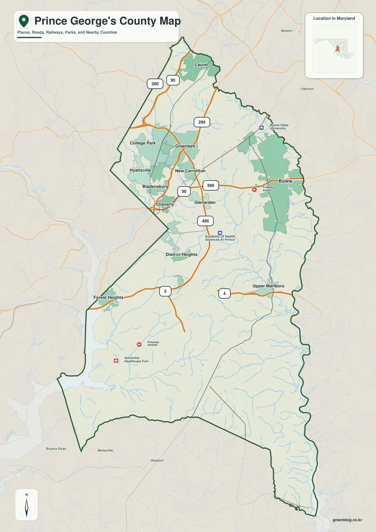
The Maryland State Archives identifies Upper Marlboro as the county seat, while Prince George’s County Government lists twenty-seven incorporated municipalities—the most of any county in Maryland. The general map shows only part of that municipal network, but it captures the major geographic contrast between the dense northern and northwestern urban belt, Bowie’s eastern position, and the broad stream-cut landscape south of Upper Marlboro.
Table of Contents
College Park, Greenbelt, and Bowie define the dense northern and central corridor
Laurel is the strongest northern anchor on the general map, close to I-95 and MD 200. Moving south, College Park and Greenbelt sit near one another along the Baltimore-Washington corridor, with MD 295 providing a major north-south reference. Roads and municipality labels are much denser here than they are in the southern half of the county.
Hyattsville and Bladensburg sit close to the Washington boundary west of College Park, while Greenbelt and New Carrollton extend eastward. Cheverly and Glenarden are useful references around U.S. 50. Because several municipalities are separated by relatively short distances, the regional highways are often more useful for orientation than any single city label.
Bowie is one of the most prominent eastern city labels. U.S. 50 crosses the Bowie side, Freeway Airport is marked nearby, and Bowie State University appears to the northwest. The city’s location also brings the Patuxent side of the county into view, making Bowie a useful transition point between the northern urban corridor and the lower-density eastern interior.
A practical way to read the north is to use I-95 around Laurel, MD 295 near College Park and Greenbelt, and U.S. 50 toward New Carrollton and Bowie. The general map is not a live traffic product, so congestion, construction, incidents, and closures should be checked with current Maryland transportation information and a navigation service.
Upper Marlboro and MD 4 reveal how quickly the landscape opens south of the Beltway
Upper Marlboro sits in the southeastern interior and serves as the county seat. MD 4 provides a strong east-west road reference nearby, while MD 5 links the southern county with the Washington side. South of the dense northern municipalities, settlement labels become much less frequent and streams occupy a larger share of the visual landscape.
District Heights lies closer to the western-central metropolitan side near I-495, while Forest Heights appears farther southwest toward the Potomac. Potomac Airfield and Adventist Healthcare Fort are marked in the southern interior. Large developed clusters are less common here, and the road pattern responds more visibly to creek valleys and rolling terrain.
The county’s eastern boundary follows the Patuxent River for a substantial distance, while the Potomac River forms a major western and southwestern boundary. Maryland State Archives material describes those rivers as key county boundaries. That helps explain the long, irregular county outline and why the east and southwest look so different from the Washington-facing northwest.
In the southern county, apparent straight-line proximity does not always translate into a short drive because creeks and low valleys interrupt direct routes. Use the static map for geographic orientation and current routing tools for exact mileage and travel time.
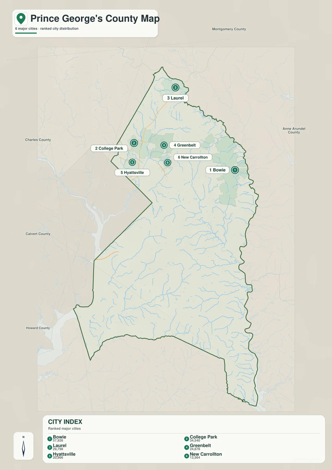
The City Index concentrates all six ranked cities in the northern half of the county
The City Index ranks Bowie, College Park, Laurel, Greenbelt, Hyattsville, and New Carrollton. It prints the values 57,926 for Bowie, 34,540 for College Park, 29,798 for Laurel, 24,678 for Greenbelt, 20,966 for Hyattsville, and 13,564 for New Carrollton. The graphic does not identify a reference year or statistical definition, so those figures should not be presented as current population counts. Current values should come from the latest U.S. Census Bureau or municipal data.
The distribution is more useful than the ranking itself. Bowie stands apart in the east, Laurel sits at the northern tip, and College Park, Greenbelt, Hyattsville, and New Carrollton cluster in the northwest and north-central area. All six are in the northern half of the county, reinforcing the much lower settlement density visible farther south on the general map.
The six ranked places are only a small part of the county’s municipal system. Prince George’s County Government lists twenty-seven incorporated municipalities, including Upper Marlboro, Bladensburg, District Heights, Forest Heights, and many others that do not appear in the City Index. The graphic is therefore a selected city-distribution view rather than a complete municipal directory.
No connector lines or mileage values are printed between the city markers. The index cannot be used to estimate driving distance from Bowie to College Park or Laurel. It works well for a quick overview of where the largest labeled cities are concentrated, with the full road map and current routing information used for actual travel.
Patuxent and Potomac rivers frame a county crossed by Piscataway and Mattawoman creeks
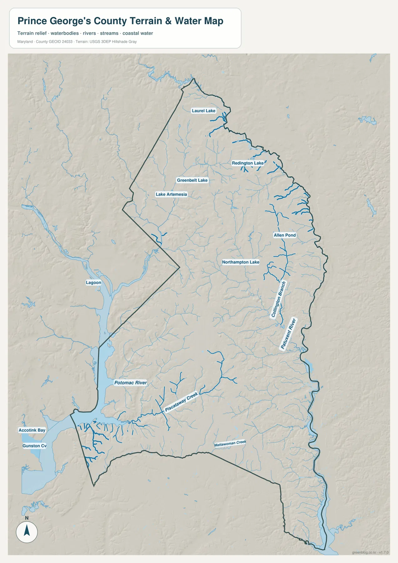
The largest boundary features on the water map are Patuxent River on the east and Potomac River on the west and southwest. Patuxent follows a long section of the county edge, while the Potomac side opens into broad water farther south. Between the two rivers, a dense network of tributaries divides the southern interior into many small valleys.
Piscataway Creek is one of the clearest southern streams and runs westward toward the Potomac system. Mattawoman Creek appears near the southern boundary. Accotink Bay and Gunston Cove are labeled beyond the county as useful regional references. The creek network makes the southern county look much more dissected than it does on the road map.
Collington Branch is labeled in the east-central county, with numerous small tributaries leading toward the Patuxent. Bowie also has recognizable local water landmarks such as Allen Pond and Northampton Lake. In the north, Laurel Lake, Redington Lake, Greenbelt Lake, and Lake Artemesia provide smaller but useful references near the urban corridor.
Patuxent River Park provides a real-world example of the eastern river landscape near Upper Marlboro. Prince George’s County Parks describes a 7,800-acre riverfront park with wetlands, trails, boat access, and other outdoor facilities. The water map here is a broad geographic reference rather than a flood map, depth chart, navigation product, or legal water-boundary source, so specialized decisions require current FEMA, USGS, Maryland, or local information.
Interior ridges stand above the low Patuxent and Potomac river corridors
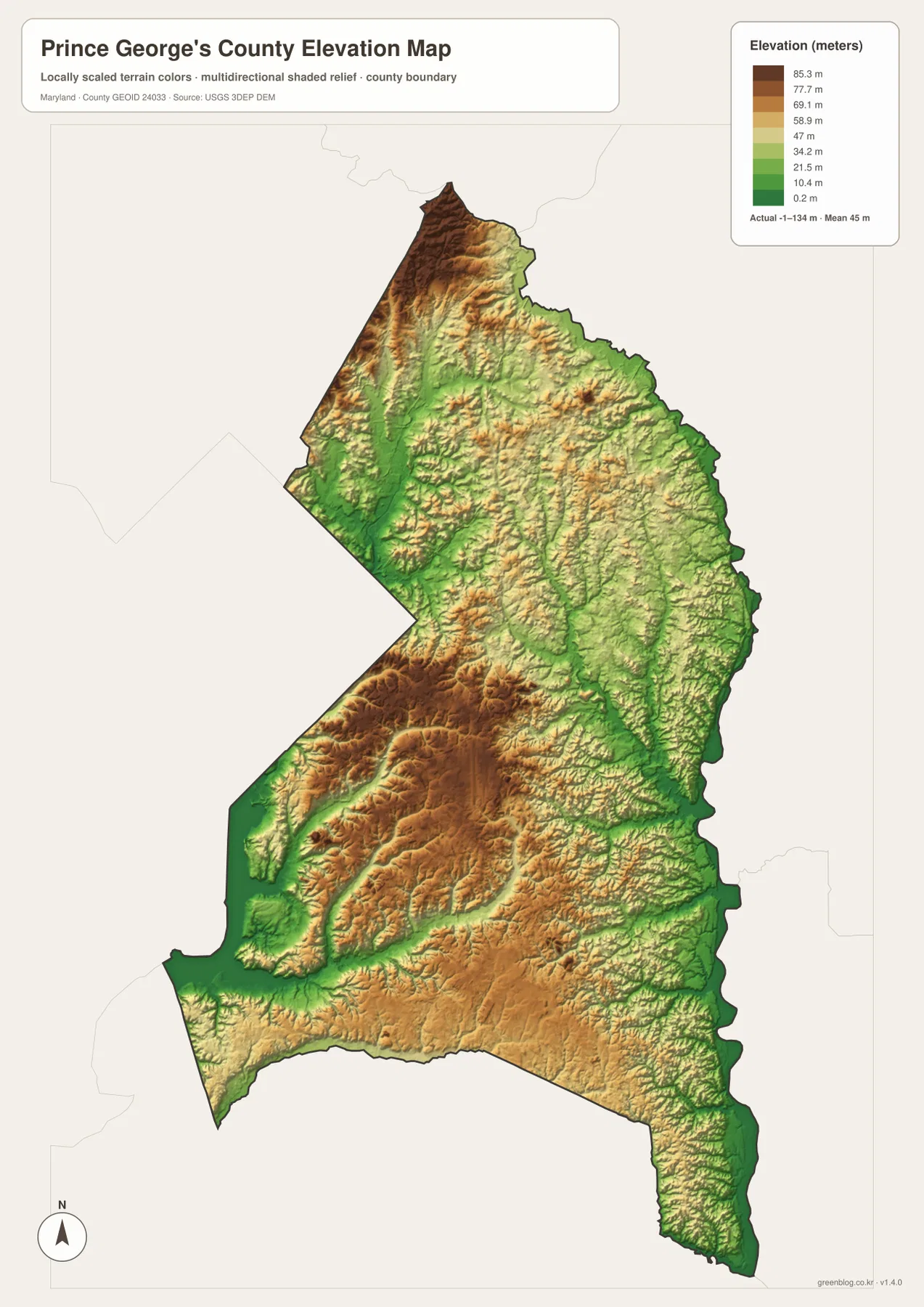
The elevation graphic reports an actual data range from -1 to 134 meters and a mean elevation of 45 meters. Those figures describe the range in the supplied elevation dataset and should not be treated as parcel-level survey elevations. Higher brown terrain is concentrated in parts of the northwest and a broad south-central interior, while green lowlands follow the major rivers and stream valleys.
Northwest of College Park and south of Laurel, repeated ridges are separated by small drainage valleys. Farther south, relatively high interior ground reappears, but creek channels carve long lower corridors through it. The county is not mountainous, yet the relief is strong enough to make the river and stream network obvious.
The Patuxent boundary is largely low, and tributaries create green corridors westward into the Bowie and Upper Marlboro sides. Low terrain also follows the Potomac and Piscataway Creek in the southwest. Comparing the elevation and water views shows that most of the strongest lowlands are tied directly to rivers and creek valleys.
The -1 to 134 meter range is not a substitute for exact road, building, or property elevation. Engineering, surveying, drainage design, and flood-risk work require authoritative USGS elevation information, professional measurements, and current FEMA or local flood products. Elevation color alone cannot determine actual flood exposure.
Choose the north for city and highway detail, and the south and east for river-valley context
The general county map is the best starting point for Laurel, College Park, Greenbelt, Bowie, Upper Marlboro, I-95, MD 295, U.S. 50, and I-495. The City Index is cleaner when the goal is simply to compare six ranked cities. For natural geography, the water map highlights the Potomac and Patuxent rivers, Piscataway Creek, Mattawoman Creek, and the urban lakes, while the elevation map explains the difference between the interior ridges and the lower river corridors.
Prince George’s County’s twenty-seven incorporated municipalities are especially dense in the northern and northwestern part of the county, although Bowie and Upper Marlboro provide important eastern references. The City Index includes only six of those municipalities, so it should be paired with the full county map and official municipality information when administrative coverage matters. Patuxent River Park adds another useful contrast by showing how extensive riverfront and wetland landscapes remain within the same county as the dense Washington-area communities.
The downloadable originals are JPG files measuring 2572 × 3638 pixels each. They work well in full-page documents and can be enlarged around College Park, Bowie, Upper Marlboro, the Patuxent River, or other areas for classroom material, presentations, and personal reference. Enlargement does not add live traffic, parcel boundaries, flood zones, water depth, or survey-grade elevation, so specialized decisions should always use current official data.
Frequently Asked Questions
What is the county seat of Prince George’s County, Maryland?
Upper Marlboro is the county seat. The Maryland State Archives identifies Upper Marlboro as the county seat, and the general map places it in the southeastern interior near MD 4 and several local roads.
Does the six-city index include every incorporated municipality in Prince George’s County?
No. The City Index shows Bowie, College Park, Laurel, Greenbelt, Hyattsville, and New Carrollton, while Prince George’s County Government lists twenty-seven incorporated municipalities. The index is therefore a simplified selected-city view rather than a complete municipal directory.
Why is Patuxent River important on the county map?
Patuxent River forms a long section of the eastern county boundary and receives many smaller tributaries from the interior. The water map is useful for geographic context, but flood, boating, depth, and regulatory decisions require dedicated current official sources.
Map File Information
The ZIP archive contains high-resolution JPG maps of Prince George's County matching the map themes described on this page.
- Included Files: county and major roads map, City Index map, terrain and water map, elevation map
- Printable Size: 2572 × 3638 pixels each
- File Type: JPG
Related Maps
Sources and References
- Prince George’s County Government – About PGC
- Maryland State Archives – Prince George’s County
- Prince George’s County Parks – Patuxent River Park
- U.S. Census Bureau – TIGER/Line Shapefiles
- USGS – National Hydrography
- USGS – 3D Elevation Program
Green Map creates custom-edited map images using open geographic data sources such as geoBoundaries, Natural Earth, OpenStreetMap, and government open data. These maps are edited visual materials, not raw data files, and are provided for education, documents, presentations, and graphic reference.