Allegany County sits in the mountainous western arm of Maryland, with Cumberland and Frostburg forming the most concentrated urban area and a narrower chain of communities extending southwest through Midland, Lonaconing, Barton, and Westernport. I-68 and U.S. 40 cross the county through a landscape of long ridges and stream valleys, while the eastern half is much less urbanized. This page compares roads and settlements, the ranked city distribution, waterways, and elevation, and the matching high-resolution JPG map files are available in one downloadable ZIP archive.
Allegany County Government identifies Cumberland as the county seat and lists seven municipalities in the county. The supplied maps make the uneven settlement pattern especially clear. Cumberland, La Vale, and Frostburg sit close to the main east-west transportation corridor; communities along Georges Creek form a separate southwestern chain; and the eastern side contains long mountain sections with fewer major place labels. That contrast between populated valleys and broad ridge country is the best starting point for understanding the county.
Table of Contents
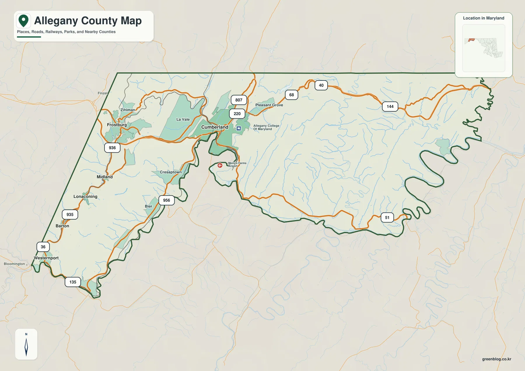
Cumberland and Frostburg sit on the county’s strongest transportation corridor
Cumberland is the easiest landmark on the general county map. La Vale lies immediately to the west, and Frostburg is farther along the same broad corridor. I-68 and U.S. 40 provide the clearest east-west references, while U.S. 220 reaches north and south from the Cumberland area. The map also labels Allegany College of Maryland and Mexico Farms Airport, giving the central part of the county a few additional landmarks beyond city names and highway numbers.
North of Cumberland, Maryland Route 807 appears near the U.S. 220 corridor. To the east, I-68 and U.S. 40 continue through the mountains, and Route 144 follows a separate line farther east. Route 51 turns toward the southeastern boundary. These roads make the elongated eastern half easier to organize because settlement names become sparse and the road network becomes the main visual guide through the ridge-and-valley terrain.
Southwest of Frostburg, the map shifts into a narrower sequence of communities. Cresaptown appears first, followed by Midland, Lonaconing, Barton, and Westernport farther down the county. Route 36 is the dominant local north-south reference, with shorter numbered routes such as 935, 936, and 956 filling in regional connections. Unlike the broad I-68 corridor, this part of Allegany County follows a more confined valley pattern.
The eastern half of the county looks much quieter on the road layer. Long stretches of I-68, U.S. 40, and Route 144 cross mountain country where small streams are more numerous than major town labels. Travel conditions can vary with construction and winter weather, so this overview should not replace current Maryland transportation information or navigation. Its strength is regional orientation: showing how the main roads thread through a long, mountainous county.
The Georges Creek corridor creates a second chain of communities southwest of Frostburg
The southwestern arm of Allegany County is noticeably narrower than the Cumberland area. From Frostburg, the settlement pattern continues through Midland and Lonaconing to Barton and Westernport, with towns arranged along the same general valley direction. That sequence is one of the most county-specific features on the map because it shows how settlement follows available low ground instead of spreading evenly across the mountains.
Route 36 follows much of this southwestern corridor and provides the easiest road reference. Route 935 appears near Lonaconing, Route 936 is labeled west of Frostburg, and Route 956 lies south of Cresaptown. They are smaller than the interstate corridor, but they help connect actual town locations to the valley geography. Westernport sits close to the southwestern end of the county, where the map approaches the West Virginia side.
Allegany County also lies close to several state and county boundaries. Garrett County is immediately west, Pennsylvania is north of the county, and West Virginia is close along the southern side. The locator inset reinforces how far west Allegany County extends within Maryland. This border setting helps explain why the county’s regional road network is oriented not only toward central Maryland but also toward neighboring Appalachian communities outside the state.
Because ridges and valleys strongly influence the route network, straight-line proximity is not always the best guide to actual movement. Cumberland, Frostburg, Westernport, and the eastern mountain section depend on different road combinations. Reading the county as three broad areas—the central-western urban corridor, the Georges Creek southwest, and the sparsely settled east—makes the transportation map much easier to understand.
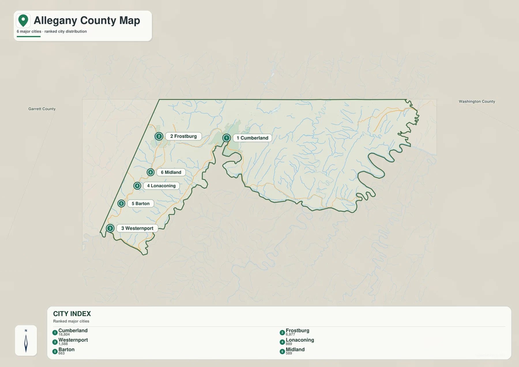
The City Index shows how strongly the ranked places cluster in the west
Six places are ranked on the City Index. Cumberland appears first with the printed value 18,804, followed by Frostburg at 6,977. Westernport is shown at 1,588, Lonaconing at 1,089, Barton at 663, and Midland at 589. The graphic does not identify a reference year or statistical definition for those values, so they should be treated as numbers printed on this particular index rather than current population counts.
The county government’s municipality page lists seven municipalities, which is a useful reminder that this six-place index is not a complete municipal inventory. Luke appears in the official list but is not ranked on the supplied City Index. The graphic is therefore best understood as a simplified ranked-city layer. For administrative completeness, the county website is the appropriate reference; for visual distribution, the City Index is much quicker to read.
The spatial pattern is unmistakable. Cumberland and Frostburg occupy the central-western portion, while Westernport, Lonaconing, Barton, and Midland are packed into the narrow southwest. No ranked marker appears across the long eastern half. That absence matches the road map, where mountain terrain and drainage lines dominate the east while the named urban places concentrate much farther west.
Unlike some city-connection graphics, this image contains no connector lines or distance labels. It should not be used to infer mileage between Cumberland, Frostburg, or Westernport. Its purpose is simpler: showing which places were ranked and where they sit within the county outline. Road questions belong on the general map, where I-68, U.S. 40, U.S. 220, and Route 36 remain visible.
Wills Creek and Georges Creek trace the valleys where settlement is concentrated
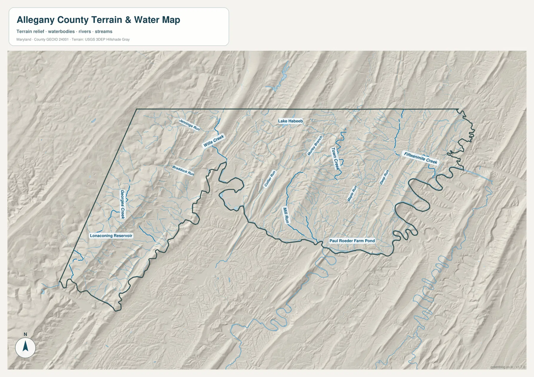
The terrain-water map helps explain why the road and city patterns look the way they do. Wills Creek is a major reference around the Cumberland side, with Jennings Run entering from the west. South and southwest of Frostburg, Braddock Run and Georges Creek follow the same general valley country where Midland, Lonaconing, Barton, and Westernport are located. The relationship between streams, low ground, roads, and settlement becomes much clearer on this layer than on the road map alone.
Georges Creek is especially useful in the southwestern arm. Lonaconing Reservoir is labeled nearby, providing another water landmark within the narrow valley. Rather than appearing randomly scattered across the mountain slopes, the southwestern communities occupy a corridor where water and transportation routes share the lower terrain. This is one of the strongest examples in the county of physical geography shaping the pattern seen on the settlement map.
Moving east introduces a different set of waterways. Collier Run, Mill Run, and Town Creek appear across the central portion, while Little Run, Deep Run, and Fifteenmile Creek are labeled farther east. Major city names largely disappear, but the drainage network becomes dense. The shaded terrain shows long parallel ridges separating these streams, so the eastern half is not an empty plateau; it is a deeply divided mountain landscape with many narrow valleys.
Lake Habeeb stands out in the north-central part of the county. Maryland DNR describes the lake at Rocky Gap State Park as a 243-acre impoundment surrounded by rugged mountains. The map places it among elongated ridges, which makes the park’s setting easy to understand even without detailed recreational information. Paul Roeder Farm Pond is labeled farther southeast, while smaller blue lines show how widely surface drainage is distributed across the county.
This is a geographic water-reference map, not a flood-risk product, legal water-boundary map, or depth chart. It does not provide real-time stream levels or flood probabilities. Anyone making safety, engineering, or regulatory decisions should use current USGS, Maryland DNR, FEMA, or other appropriate official data. Here, the water layer is most useful for connecting named streams and reservoirs with the surrounding mountain terrain.
Elevation separates the high western ridges from the Cumberland valley and eastern stream corridors
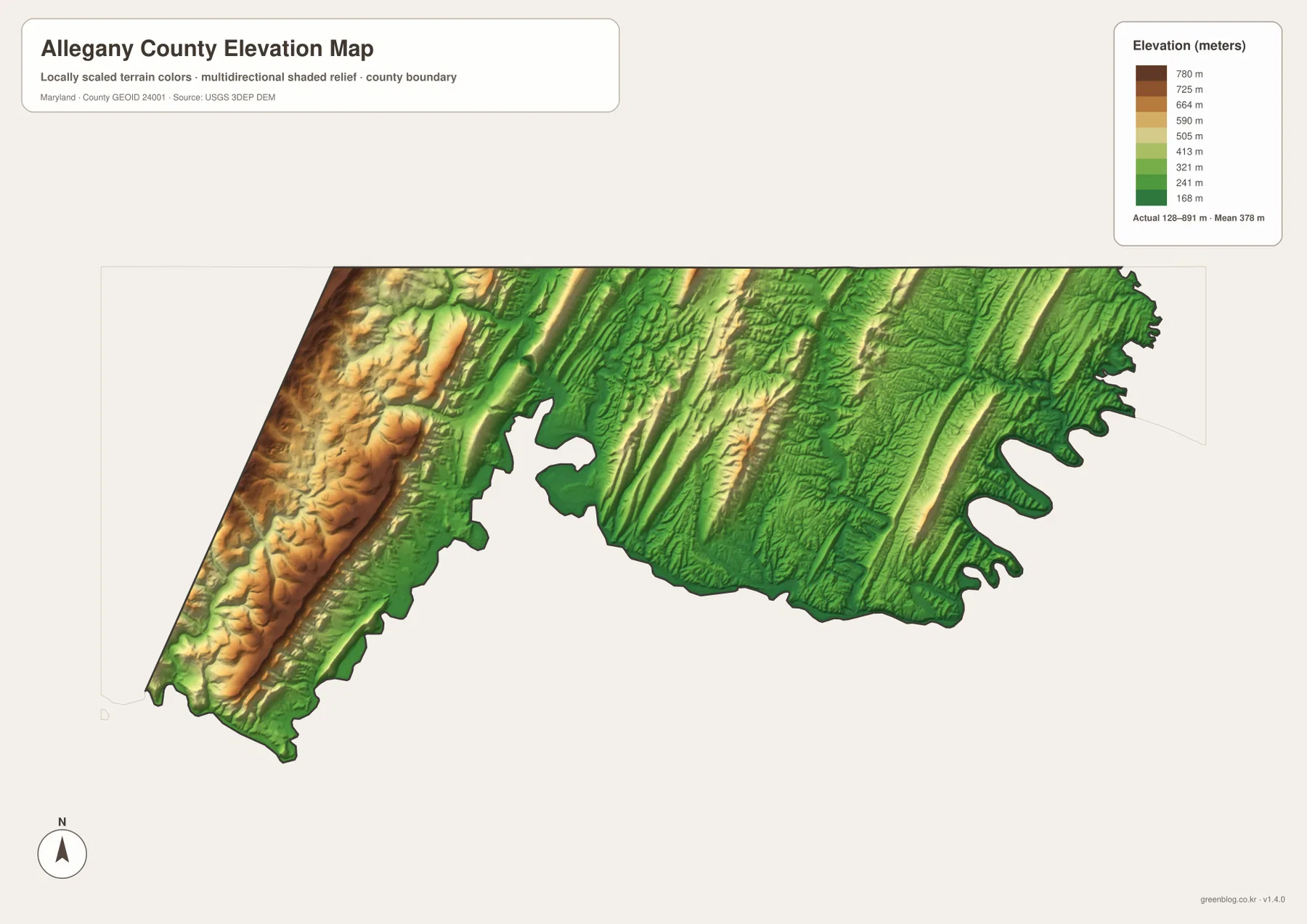
The elevation legend reports an actual county range of 128 to 891 meters and a mean elevation of 378 meters. Its colors are locally scaled to make differences inside Allegany County easier to see, so the same shade should not automatically be compared with a different county’s map. Browns and tans mark the higher terrain, while darker greens identify relatively low valleys and stream corridors.
The highest-looking band is concentrated along the western side, where warm colors form a long north-south ridge near the Garrett County side. Frostburg sits close to this higher mountain country, while the Cumberland area appears in lower green terrain. The contrast helps explain why transportation and settlement concentrate in a narrow valley even though higher ridges rise nearby.
Central and eastern Allegany County remain rugged even when they are not as high as the westernmost ridge. Narrow yellow and tan crests repeat between green valleys, producing the parallel pattern visible across much of the map. The Town Creek and Fifteenmile Creek areas occupy lower corridors between these ridges, matching the drainage arrangement shown on the terrain-water layer.
The elevation surface is designed for regional comparison, not survey or engineering measurement. The county-wide minimum, maximum, and mean are useful summary values, but a specific road, parcel, building site, or trail point requires more detailed elevation data. USGS 3D Elevation Program products or a professional survey are better sources when exact height or slope matters.
Combining roads, streams, and elevation explains why Allegany County is so unevenly settled
For road and place orientation, the general county map provides the most context. It is the best starting point for Cumberland, Frostburg, I-68, U.S. 40, U.S. 220, and the Route 36 communities. The City Index is cleaner when the goal is simply to show how the ranked places cluster in the western half. It deliberately removes most road detail, so the contrast between the populated west and the largely unmarked east becomes immediate.
The water and elevation views explain the physical setting behind that pattern. Wills Creek and Georges Creek occupy valleys used by roads and communities, while the eastern half contains many smaller streams separated by long ridges. The elevation map adds the broader height difference, especially the high western band and lower Cumberland corridor. Taken together, the maps show why a county that looks long and narrow on an outline map contains several very different local landscapes.
The downloadable originals are landscape-format JPG files measuring 3638 × 2572 pixels each. They can be placed on a full document page or enlarged around Cumberland, the Georges Creek corridor, Lake Habeeb, or the eastern ridges for classroom and presentation use. Enlarging the files does not add live traffic, legal parcel boundaries, flood hazards, or survey-grade elevation, so technical decisions still require the appropriate current source.
Allegany County is easiest to understand when the western urban corridor, the southwestern Georges Creek communities, and the long eastern mountain section are treated as distinct but connected areas. Choosing the road, city, water, or elevation view according to the question keeps the county-specific geography clear without forcing every detail into one crowded image.
Frequently Asked Questions
Which roads are the best references between Cumberland, Frostburg, and the Georges Creek communities?
I-68 and U.S. 40 are the main references between Cumberland, La Vale, and Frostburg, with U.S. 220 also meeting the Cumberland area. South of Frostburg, Route 36 becomes more useful for Midland, Lonaconing, Barton, and Westernport. Current navigation should still be used for actual routes and travel times.
Are the City Index values such as Cumberland 18,804 and Frostburg 6,977 current population figures?
They should not be treated as current population counts because the supplied graphic does not identify a reference year or statistical definition. This page treats them only as values printed on the City Index. Use the latest U.S. Census Bureau or official county data when current demographic figures are needed.
Can the 128 to 891 meter elevation range be used to determine the exact height of a property or road?
No. The range summarizes the elevation surface used for the county-wide map and helps compare high ridges with low valleys. It is not a parcel-level survey. Exact elevations and slopes should be checked with detailed USGS elevation data or professional surveying when engineering, construction, or legal accuracy is required.
Map File Information
The ZIP archive contains four high-resolution JPG maps of Allegany County matching the map themes described on this page.
- Included Files: county and major roads map, City Index map, terrain and water map, elevation map
- Printable Size: 3638 × 2572 pixels each
- File Type: JPG
Related Maps
Sources and References
- Allegany County Government – Our Municipalities
- Maryland DNR – Rocky Gap State Park
- U.S. Census Bureau – TIGER/Line Shapefiles
- USGS – National Hydrography
- USGS – 3D Elevation Program
Green Map creates custom-edited map images using open geographic data sources such as geoBoundaries, Natural Earth, OpenStreetMap, and government open data. These maps are edited visual materials, not raw data files, and are provided for education, documents, presentations, and graphic reference.