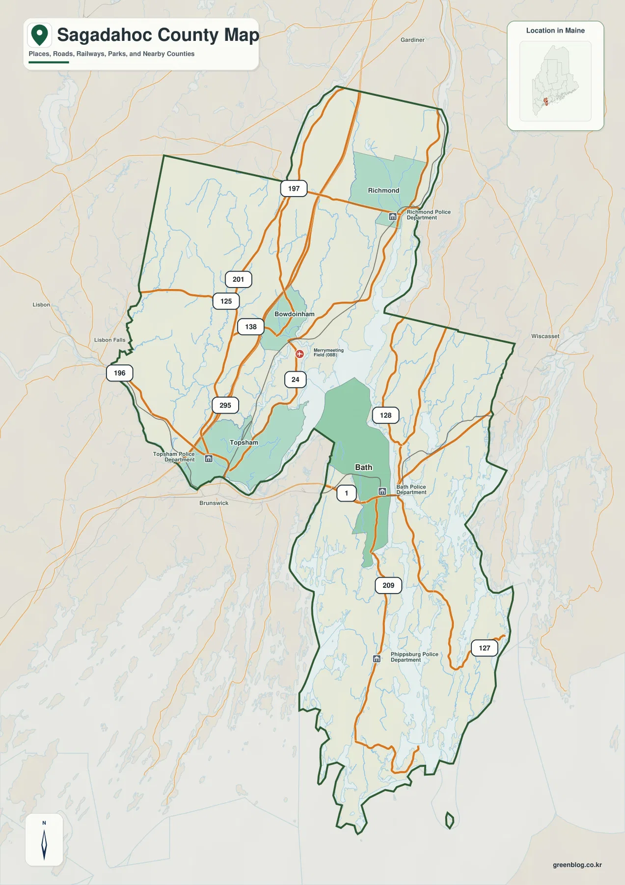
Sagadahoc County occupies a compact but geographically varied part of southern coastal Maine. Bath and Topsham anchor the busiest road-and-settlement area, Richmond and Bowdoinham extend the county northward, and long coastal peninsulas reach south toward tidal channels and the Atlantic. The Kennebec River is the easiest feature to use as a reference because it links the inland and coastal portions of the county. This page explains the places, roads, rivers, lakes, and coastal water shown on the supplied maps, and the same three map themes are available as high-resolution JPG files in a downloadable ZIP package.
The county changes quickly from north to south. Around Richmond, Bowdoinham, and Topsham, the map is dominated by inland roads and river corridors. South of Bath, the coastline becomes more intricate, with narrow landforms, inlets, islands, and tidal waterways breaking up the outline. The City Index is much simpler and marks only Bath as a ranked major city, while the main county map provides a broader view of towns and road connections. Comparing those images with the terrain-and-water map makes the county’s unusual shape much easier to understand.
Table of Contents
Roads and boundaries from Bath and Topsham north to Richmond
Bath and Topsham are the most useful starting points on the main county map. Bath sits close to the Kennebec River with U.S. 1 passing through the city, while Topsham is near the southwestern edge of the county where several roads converge. Maine’s official county information identifies Bath as the Sagadahoc County seat, which also makes it a natural administrative reference point. The map shows that the two communities are not simply points on a flat grid; rivers, bays, boundary turns, and bridges strongly influence how the southern part of the county is organized.
Moving north, Bowdoinham and Richmond provide two additional anchors. Routes 24, 125, and 138 appear around the Bowdoinham area, while Route 197 crosses the Richmond area farther north. Route 201 runs along the western side of the county map, and I-295 is visible near Topsham and Bowdoinham. MaineDOT describes I-295 as the only Interstate highway serving Sagadahoc County, so it is the clearest high-speed regional reference for connections toward Portland to the south and Augusta to the north, even though it does not directly serve every coastal town.
The road pattern changes south of Bath. Route 209 continues down the long Phippsburg peninsula, while Route 127 is shown on the narrower eastern section of the county. Route 128 appears north and east of Bath, connecting another part of the lower county with the broader road network. These roads are less grid-like than the routes farther inland because the coastline, tidal channels, and long peninsulas shape where a road can run. On the full map, the contrast between the wider northern land area and the elongated southern sections is immediately visible.
Labels outside the county add useful regional context. Brunswick appears just southwest of the boundary, Gardiner is to the north, Wiscasset is to the east, and Lisbon and Lisbon Falls are shown to the west. Those external labels help place Sagadahoc County within southern Maine without requiring a separate statewide map. The northern and western edges contain several relatively straight segments, while the eastern and southern outline becomes more irregular as water features and coastal landforms break up the border.
This road-and-boundary image should be treated as an orientation map rather than a live navigation tool. It is excellent for identifying the county shape, finding a town, and seeing which numbered route leads in a general direction. It does not show construction, seasonal closures, traffic, or current bridge conditions. For actual travel, readers should check current MaineDOT information and a live navigation service. For classroom use, presentations, and printed county overviews, however, the lack of live detail keeps the map readable.
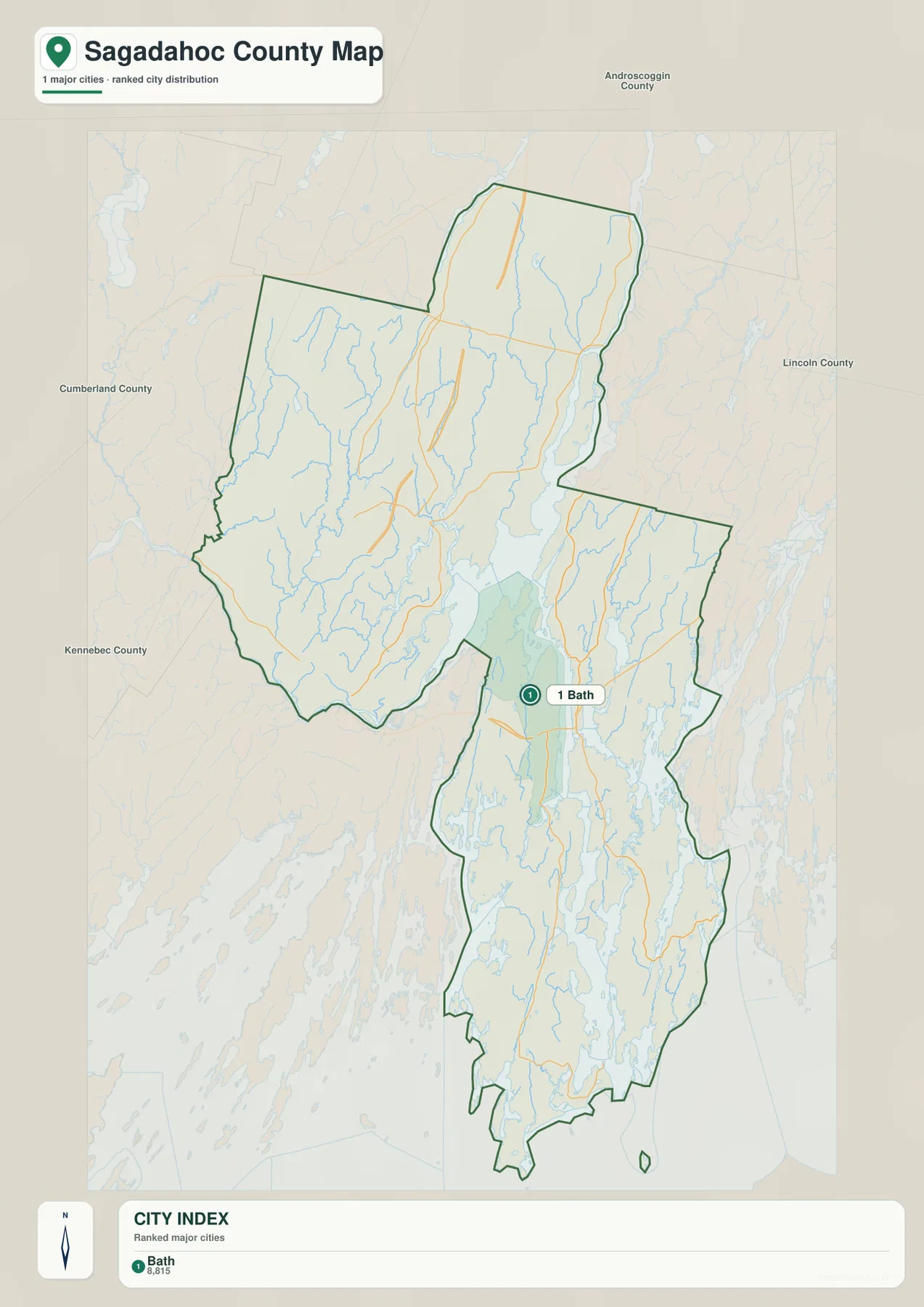
A City Index that deliberately keeps the focus on Bath
The City Index removes most of the small-place and road detail and places a single ranked marker on Bath. The index shows Bath in the number-one position with the value 8,815. Because the image itself does not provide a reference year or explain the statistical definition behind that number, it should not be cited as a current population estimate. Anyone who needs current demographic data should use a recent U.S. Census Bureau release. The stronger use of this map is to show where Bath sits within the county at a glance.
Maine’s Secretary of State county page offers helpful context for the sparse city display. It lists Bath as the county’s city and names Arrowsic, Bowdoin, Bowdoinham, Georgetown, Phippsburg, Richmond, Topsham, West Bath, and Woolwich as towns. That classification helps explain why a city-focused index can look much emptier than the main county map. It does not mean that Topsham, Richmond, Phippsburg, or the other towns are unimportant; it simply means the City Index is not intended to be a complete settlement map.
Bath is also a useful geographic pivot because the county broadens to the northwest and narrows into coastal landforms to the south. Topsham and Bowdoinham occupy the wider inland section, with Richmond at the far northern end. South of Bath, the outline extends much farther than the single city marker might suggest. If someone looked only at the City Index, the county could appear centered tightly around Bath, but the full boundary makes clear that Sagadahoc reaches well beyond the city in both directions.
The background labels Androscoggin, Cumberland, Kennebec, and Lincoln counties around Sagadahoc. These neighboring-county names are valuable when the goal is statewide orientation rather than street-level detail. They show how this small coastal county sits between several larger county areas. For a presentation slide that needs only one labeled city and surrounding county context, the simplified image can be easier to read than the road map. For town locations and route numbers, it is intentionally too sparse.
Unlike some city-connection graphics, this City Index does not draw direct-distance lines from Bath to other places. There are no mileage labels that should be interpreted as driving or straight-line distance. Readers should therefore avoid estimating travel distances from the visual spacing of the map. Use the image for relative position, then switch to the main map or a dedicated distance tool when mileage matters.
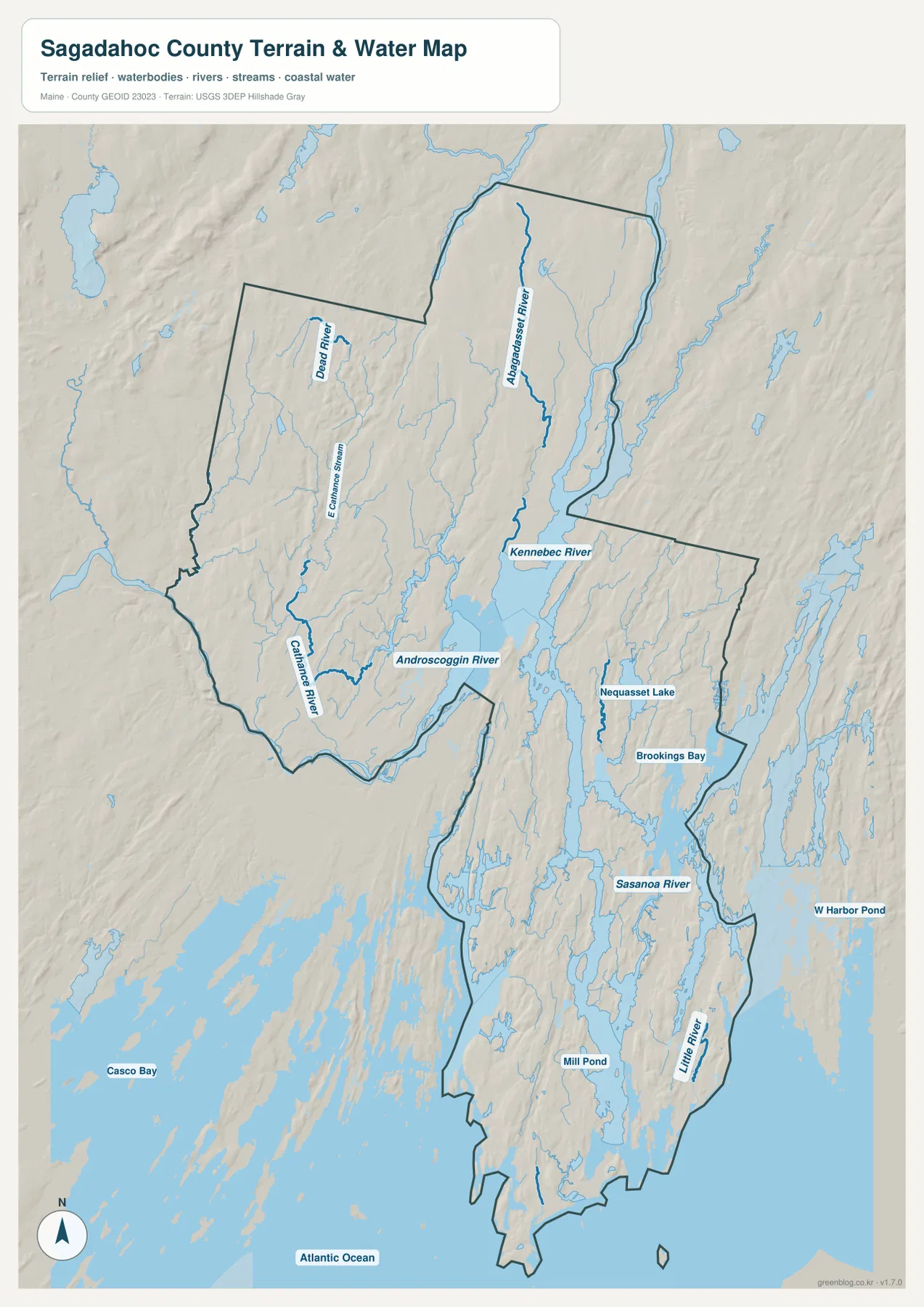
From the Kennebec and Androscoggin rivers to Sasanoa River and the Atlantic
The terrain-and-water map reveals why water is so important to Sagadahoc County’s shape. The Kennebec River enters the county from the north and continues south past the Bath area toward coastal water. To the west, the Androscoggin River reaches the county’s inland water network, while smaller features such as the Cathance River, Dead River, and Eastern Stream appear across the northwestern section. Reading the water features alongside the road map helps explain why some roads follow river valleys, narrow crossings, or longer routes around tidal water.
The western inland section includes the Androscoggin River and Cathance River, while the Kennebec provides the strongest central north-south reference. The map also labels the Abagadasset River farther north in the Kennebec-side drainage. Instead of trying to memorize every stream, it is easier to find the Kennebec first and then trace smaller waterways outward. That approach also makes it easier to compare Bowdoinham and Richmond with the more heavily dissected coast near Bath.
South of Bath, water occupies much more of the map. Sasanoa River is labeled east of the lower Kennebec, and the surrounding area contains narrow channels, coves, islands, and deeply indented shorelines. Nequasset Lake and Brookings Bay appear in the east-central portion of the county, while Mill Pond and Little River are labeled farther south. Casco Bay is shown outside the county to the southwest, and the Atlantic Ocean fills the lower edge of the map, making the inland-to-coast transition especially easy to see.
This is a reference map of water location, not a nautical chart or flood-hazard product. It does not provide water depth, channel markers, tidal predictions, current speed, legal water boundaries, or flood probabilities. Boating, fishing, flood planning, and emergency decisions require current information from agencies such as NOAA, USGS, FEMA, and relevant Maine authorities. The map’s value is the regional overview: it shows where the major rivers, lakes, bays, and coastal waters sit in relation to the county boundary.
The shaded relief should be read just as cautiously. It adds a general sense of ridges, low valleys, and drainage direction, but it is not survey-grade elevation data. Exact height, slope, construction, or engineering questions require a proper elevation dataset such as the USGS 3D Elevation Program. For ordinary map reading, the relief is useful because it keeps the rivers from looking like isolated blue lines and shows how the waterways fit into the surrounding land surface.
Together, the three images let the reader adjust the level of detail for a particular task. The main county map works best when roads, towns, and boundaries matter. The City Index is cleaner when Bath is the only location that needs to be emphasized. The terrain-and-water version is the strongest choice for explaining the Kennebec River, Sasanoa River, Nequasset Lake, bays, and the coastline. Using them as a set is especially helpful when comparing Sagadahoc’s inland northern section with its much more water-dominated southern half.
The downloadable ZIP contains three high-resolution JPG files matching the themes shown in this article, and each image measures 2572 × 3638 pixels. They can be enlarged on screen or used as references for print, lessons, presentations, and personal geographic comparison. These blog maps should not replace official legal boundary records, survey data, live traffic information, nautical charts, or flood products when those specialized uses matter.
Frequently Asked Questions
Why does the Sagadahoc County City Index show only Bath?
The supplied City Index is a simplified major-city graphic and places its only ranked marker on Bath. Maine’s official county information also identifies Bath as the county seat and the county’s city, while Topsham, Richmond, Bowdoinham, Phippsburg, and the other incorporated places are listed as towns. The single marker should not be read as a complete settlement map; use the main county map when town and road locations matter.
Which road is the easiest map reference from Bath toward Phippsburg?
Route 209 is the clearest labeled road continuing south from the Bath area into the long Phippsburg section of the county. Route 127 appears on the eastern coastal section, so the two routes help separate different parts of the lower county. For actual driving, use current navigation and MaineDOT information because a static county map does not show road work, closures, or real-time conditions.
Can the terrain-and-water map be used for flood risk or water depth?
No. It is a regional reference showing the general locations of the Kennebec, Androscoggin, and Sasanoa rivers, Nequasset Lake, bays, and coastal water. It does not include flood zones, live river levels, tides, water depth, navigation channels, or legal water boundaries. Use current USGS, FEMA, NOAA, and Maine agency data for those specialized purposes.
Map File Information
Download the three high-resolution JPG maps of Sagadahoc County discussed on this page in one ZIP archive.
- Included Files: county and road map, City Index map, terrain and water map
- Printable Size: 2572 × 3638 pixels each
- File Type: JPG
Related Maps
Sources and References
- Maine Secretary of State – Maine Counties
- MaineDOT – Connecting Maine transportation plan
- U.S. Census Bureau – TIGER/Line Shapefiles
- USGS – National Hydrography
- USGS – 3D Elevation Program
Green Map creates custom-edited map images using open geographic data sources such as geoBoundaries, Natural Earth, OpenStreetMap, and government open data. These maps are edited visual materials, not raw data files, and are provided for education, documents, presentations, and graphic reference.