West Feliciana Parish in southeastern Louisiana is defined by a striking contrast between the Mississippi River floodplain on the west and a deeply dissected upland landscape around St. Francisville and the eastern parish. U.S. 61 and LA 10 provide the clearest road references near the parish seat, while LA 66, LA 421, LA 966, and LA 967 connect smaller rural areas across the hills. The western boundary is especially unusual because large Mississippi River bends and former channels leave the parish outline twisting around the floodplain, including small sections that appear separated across the present river. Matching high-resolution JPG originals for the maps on this page can be downloaded together in a ZIP for printing, classroom use, presentations, or detailed reference. High-resolution map files are available for download in the section below.
St. Francisville is the parish seat and the only community selected as a major city on the supplied city-index map. Louisiana’s official parish profile also identifies St. Francisville as the parish seat and town. On the general map, it sits in the south-central parish where U.S. 61 and LA 10 provide a simple starting point. From there, the Mississippi River explains the irregular west, while Bayou Sara and the Thompson Creek system help organize the hillier interior and eastern boundary.
Table of Contents
St. Francisville is the road center around U.S. 61 and LA 10
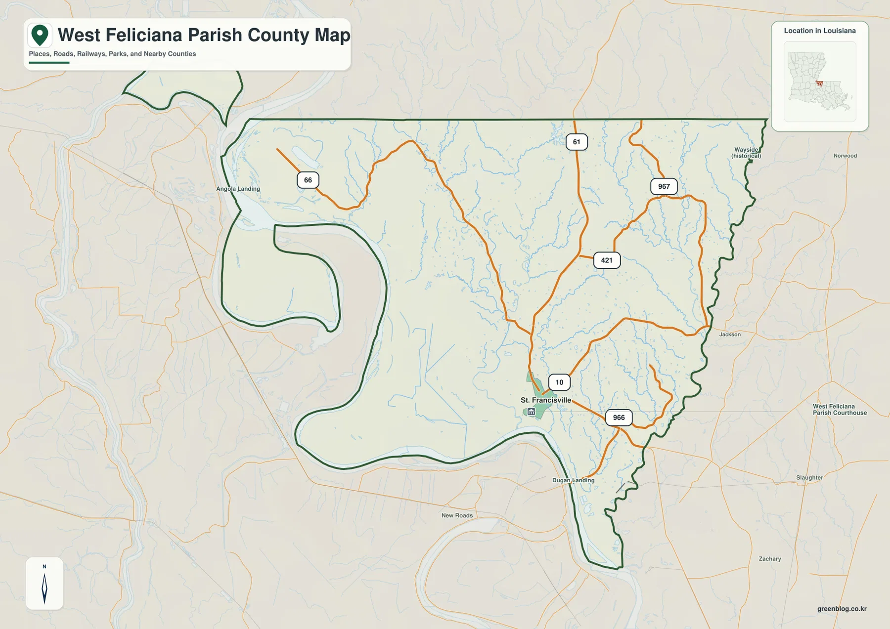
The general map places St. Francisville in the south-central part of the parish, with U.S. 61 providing the strongest north-south highway and LA 10 crossing the area east-west. LA 966 loops through the southeastern side, and LA 421 branches eastward from the U.S. 61 corridor farther north. With relatively few large settlements elsewhere in the parish, this highway cluster makes St. Francisville the clearest road reference.
Jackson appears just beyond the eastern boundary, while Dugan Landing is labeled near the river south of St. Francisville. Farther outside the parish, Slaughter, Zachary, and Norwood provide regional context. U.S. 61 remains comparatively direct, but many smaller roads bend around creek valleys and rolling ground, so road direction alone does not fully explain the local landscape.
LA 66, LA 421, and LA 967 cross the hillier northern and eastern parish
LA 66 curves through the northwestern side toward Angola Landing and the Mississippi River. U.S. 61 remains the central north-south reference, while LA 421 extends east into the interior. LA 967 runs through the eastern side close to the East Feliciana Parish boundary. These routes are especially useful because the surrounding area contains few large town labels.
The shaded relief beneath the roads shows a much more dissected surface in the north and east than along the river floodplain. Short tributaries cut narrow valleys across the uplands, and local roads often bend between them rather than forming a regular grid. Reading U.S. 61 as the center line, with LA 66 to the west and LA 967 to the east, provides a simple way to organize the broad rural half of the parish.
Old Mississippi River bends create one of Louisiana’s most unusual parish outlines
The western boundary is the most distinctive feature on the map. The Mississippi River makes broad bends around the parish, and the administrative line does not always follow the present channel exactly. West Feliciana Parish’s official hazard-mitigation material notes that the western boundary is generally formed by the Mississippi River but that small low-lying parish sections remain on the western side of the river.
Near Angola Landing and the large horseshoe-shaped western section, the relationship between present river bends and former channels becomes obvious. Raccourci Old River is particularly useful for understanding why part of the parish outline appears detached or wrapped around old meanders. This boundary pattern is far more specific to West Feliciana than a generic road description and is one of the best clues for recognizing the parish on a regional map.
The city index selects only St. Francisville as the ranked major city
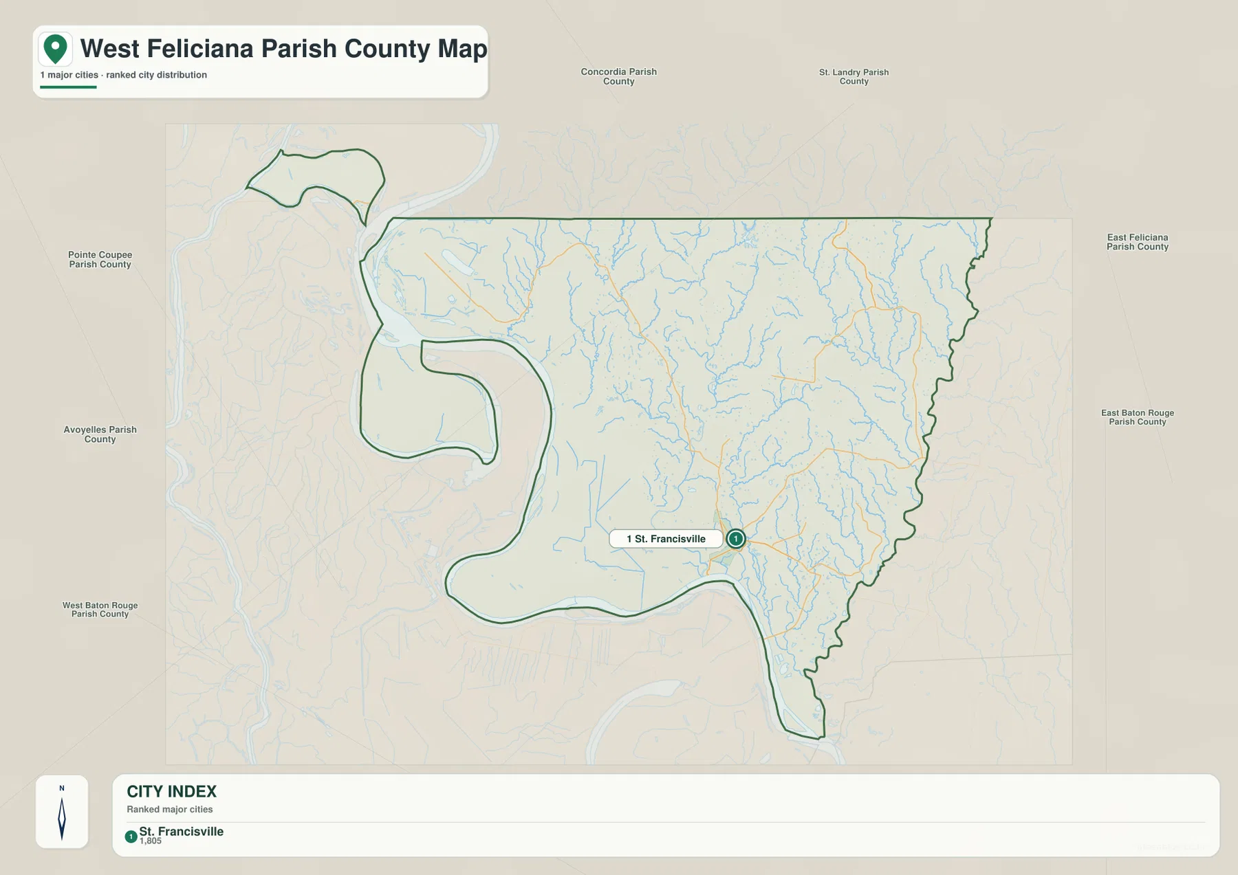
The city-index graphic contains a single selected place: St. Francisville is ranked number 1. That number is a city ranking, not a distance measurement. Jackson, Slaughter, Zachary, and Norwood appear outside the parish for context, but the index does not identify another major city within West Feliciana Parish.
The city view should therefore not be treated as a complete settlement list. Its value is to emphasize how strongly the parish is centered on St. Francisville. For the highway network, Angola Landing, the river bends, and the broad rural uplands, the detailed general map provides much more information.
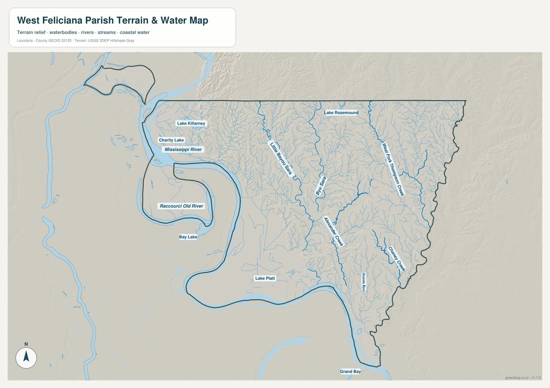
Bayou Sara and Little Bayou Sara cut through the central uplands
Bayou Sara is one of the strongest named waterways in the interior, with Little Bayou Sara running nearby to the west. Both occupy long valleys that help explain the broken, rolling relief around St. Francisville. The water map makes clear that the parish is not simply a flat river-edge landscape; much of the interior is divided by narrow stream valleys and ridges.
Lake Rosemound appears in the north, while Lake Killarney and Charity Lake lie closer to the Mississippi River side. Lake Platt is labeled farther south. These lakes are small compared with the Mississippi River, but they provide useful local references and help distinguish the low floodplain side from the more dissected uplands farther east.
Thompson Creek and Alexander Creek define the eastern and southeastern drainage
Little Fork Thompson Creek follows the eastern side, while Alexander Creek crosses the southeastern interior toward the lower parish. Camancy Creek and Gans Bay provide additional references in the same area. Official parish planning material describes Thompson Creek as a major eastern boundary waterway, and the supplied map shows how closely the creek system and parish edge are related.
The eastern landscape is more finely cut by tributaries than the Mississippi floodplain to the west. That difference is visible in the shaded terrain as well as in the stream network. The terrain-and-water map is intended for general geographic reference only; it does not provide flood-zone classifications, water depth, navigability, legal property boundaries, or current levee and drainage-system conditions.
Using St. Francisville, the river, and the creek valleys simplifies the parish
A practical first pass begins with St. Francisville and the U.S. 61–LA 10 intersection. Add LA 66 to the northwest and LA 967 to the east, then use the Mississippi River as the major western and southern boundary reference. That framework is enough to understand most of the road map before adding the smaller state highways.
For the physical landscape, Raccourci Old River, Bay Lake, and Lake Killarney help explain the old Mississippi meanders, while Bayou Sara, Little Bayou Sara, and Alexander Creek reveal the interior valleys. The general map is best for roads and the unusual parish boundary, the city index for St. Francisville’s central role, and the terrain-and-water map for river history, creek systems, and relief.
High-resolution JPG files make the irregular river boundary easier to inspect
The downloadable ZIP contains the original JPG files corresponding to the three previews on this page: the general parish map, the ranked city map, and the terrain-and-water map. Each original image is 3638 by 2572 pixels, providing more room to inspect route numbers, small tributaries, lake labels, and the winding Mississippi River boundary than the web preview. The larger format is especially useful around the old meander sections and the stream-filled hills north and east of St. Francisville.
Choose the general map when St. Francisville, the highways, and the unusual administrative boundary need to appear together. Use the city index when the parish’s single selected major city is the main subject. The water map is the better choice for the Mississippi River, Bayou Sara, Thompson Creek, Alexander Creek, and the rolling terrain. These are general reference maps rather than legal boundary, survey, flood-risk, engineering, or real-time navigation products.
Frequently Asked Questions
What is the parish seat of West Feliciana Parish?
St. Francisville is the parish seat. Louisiana’s official parish profile identifies St. Francisville as the seat, and the supplied map places it near U.S. 61 and LA 10 in the south-central parish.
Does the number 1 on the city map show distance?
No. It is a ranking that marks St. Francisville as the single selected major city, not a straight-line or driving-distance measurement. The city index is a simplified urban reference rather than a complete list of communities.
Why do parts of West Feliciana Parish appear west of the present Mississippi River?
Long-term river meandering left administrative boundaries that do not perfectly match the present channel. Features such as Raccourci Old River help explain the detached-looking sections around former Mississippi River bends. For exact legal boundaries, current official boundary data should be used.
Map File Information
The ZIP contains the original high-resolution JPG files corresponding to the general parish map, ranked city map, and terrain-and-water map shown on this page.
- Included Files: parish map JPG, ranked city map JPG, terrain-and-water map JPG
Related Maps
Sources and references
For parish-seat information, see the Louisiana.gov West Feliciana Parish Profile and West Feliciana Parish Government. Road and boundary context is available from the Louisiana DOTD West Feliciana Parish Official Map. General boundary data are documented by the U.S. Census Bureau TIGER/Line Shapefiles, and national water-feature data are documented through USGS National Hydrography.
Green Map creates custom-edited map images using open geographic data sources such as geoBoundaries, Natural Earth, OpenStreetMap, and government open data. These maps are edited visual materials, not raw data files, and are provided for education, documents, presentations, and graphic reference.