Winn Parish sits in north-central Louisiana, where Winnfield forms the clearest local center and a web of highways, smaller roads, creeks, and parish boundaries spreads outward in every direction. This page brings those elements together in three complementary maps. The high-resolution JPG files can be downloaded below, so the material works both as an on-screen reference and as a printable map set for study, planning, or local orientation. High-resolution map files are available for download in the section below.
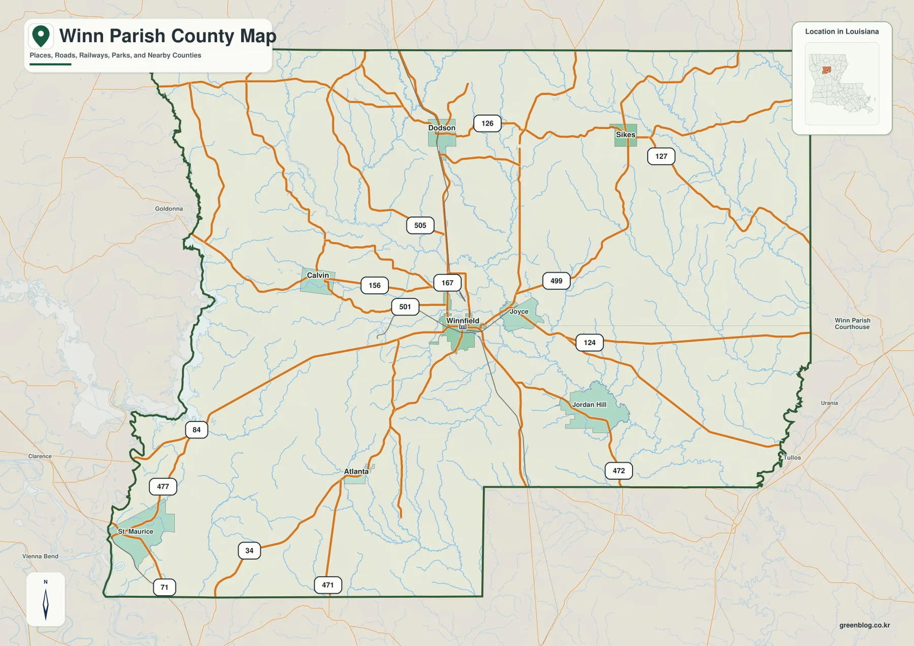
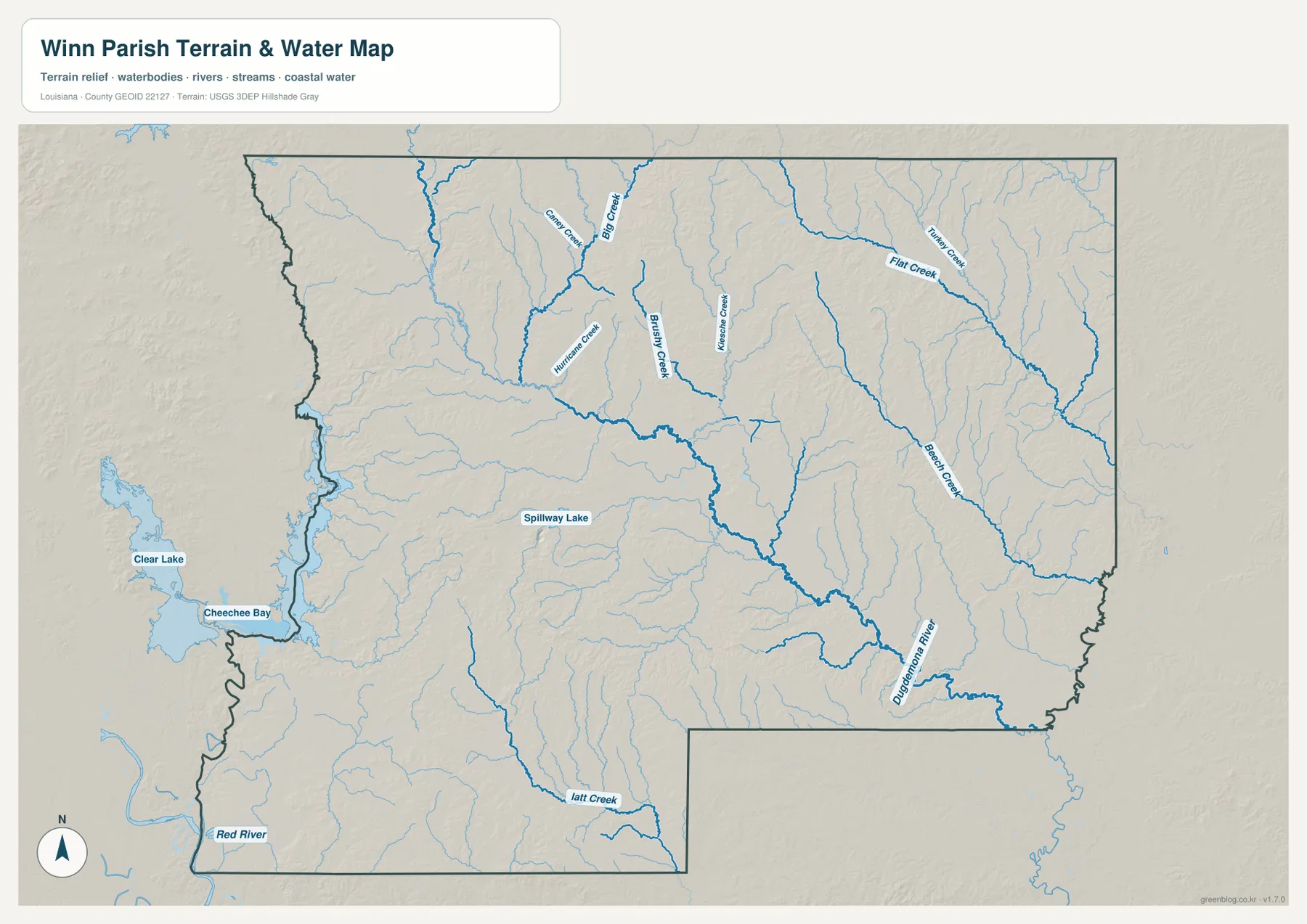
The first thing to notice is how much of the parish can be understood from Winnfield. Louisiana’s official parish profile identifies Winnfield as the parish seat, and the map shows several routes converging there before continuing toward Dodson, Sikes, Calvin, Atlanta, Joyce, Jordan Hill, and communities beyond the parish line. The terrain-and-water view adds another layer by naming the Dugdemona River, Big Creek, Hurricane Creek, Brushy Creek, Flat Creek, Beech Creek, and other waterways that cross the landscape.
Table of Contents
Winnfield at the road center of Winn Parish
On the county map, Winnfield lies close to the middle of the parish and functions as the most useful reference point for reading the road network. U.S. 84 crosses the parish from west to east through Winnfield, while U.S. 167 runs north from Winnfield toward Dodson. The two U.S. highways overlap briefly in Winnfield, which helps explain why the city stands out as the main road junction on the map. Smaller numbered routes spread toward Calvin, Sikes, Joyce, Atlanta, Jordan Hill, and the more rural edges of the parish.
The parish boundary is irregular rather than box-shaped. The western side bends around several stream corridors, the eastern side has its own changes in direction, and the southern edge steps around neighboring territory. Seeing the boundary together with the roads makes it much easier to understand when a route is inside Winn Parish and when it is approaching another parish. Goldonna appears just outside the western side, while Tullos and Urania are shown beyond the eastern boundary, giving useful regional context without turning the map into a larger state road map.
Several smaller communities help define the internal geography. Calvin is west of Winnfield, Dodson and Sikes are to the north, and Atlanta lies to the southwest. Joyce is close to Winnfield on the east side, Jordan Hill appears farther southeast, and St. Maurice sits near the southwestern edge. These places are not clustered into one continuous urban area; instead, they are separated by forested land, creeks, and rural road corridors. The map is therefore most useful when the place names are read together with the routes connecting them.
The southern and southwestern road pattern is noticeably different from the north. Route 34 and Route 471 appear around the Atlanta area, U.S. 71 reaches the parish near the southwest corner, and U.S. 84 continues across the western half toward Winnfield. To the north, U.S. 167 provides the clearest line between Winnfield and Dodson, while other state routes branch toward Sikes and the northeastern part of the parish. This combination gives Winnfield a central role even though the parish itself covers a broad rural area.
Use this map as a general location and boundary reference rather than as a parcel or legal survey. It is well suited to answering questions such as where a village sits within the parish, which major road leads toward it, or which neighboring area lies beyond a particular edge. Exact property ownership, turn-by-turn driving, and current road restrictions require more specialized and up-to-date sources.
How Dodson, Sikes, Calvin, and Atlanta relate to Winnfield
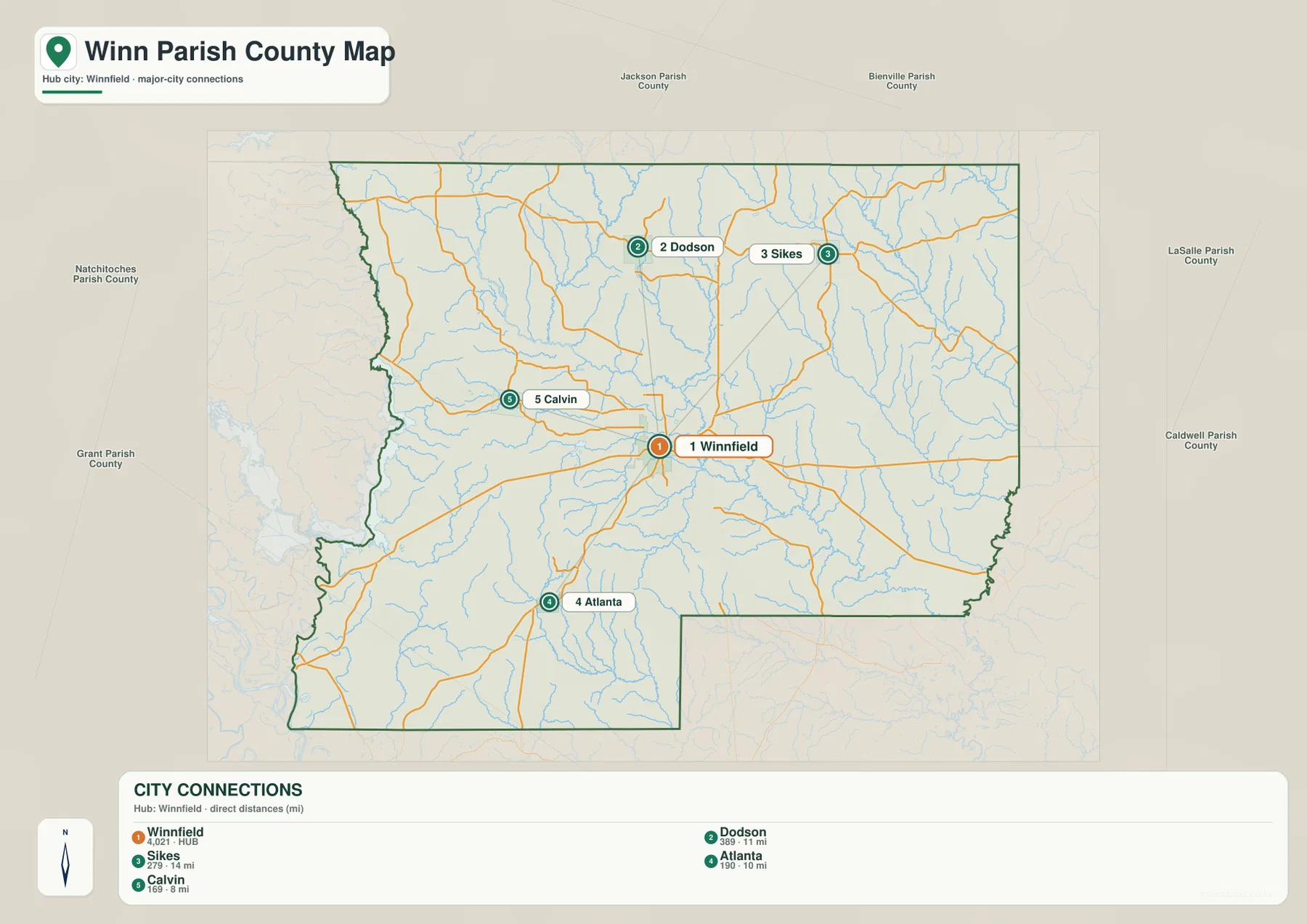
The city-connections map simplifies the parish by using Winnfield as the hub and comparing four communities around it. The connector distances are straight-line distances, not driving distances. Calvin is shown at about 8 miles from Winnfield, Atlanta at about 10 miles, Dodson at about 11 miles, and Sikes at about 14 miles. Those measurements are useful for comparing relative separation, but road travel will usually be longer because highways and local roads do not follow perfectly straight lines.
Dodson and Sikes are both north of Winnfield, yet the map makes clear that they occupy different parts of the parish. Dodson lies closer to the U.S. 167 corridor, while Sikes is farther east. Calvin is west of Winnfield and is the nearest of the four highlighted communities by straight-line distance. Atlanta lies southwest, reached through a different set of roads that also serve the southern part of Winn Parish. Looking at direction and distance together is more informative than reading either one by itself.
Winnfield’s road position also explains why it works well as the hub for this comparison. U.S. 84 provides an east-west route through town, U.S. 167 carries traffic north and south, and several additional roads leave the city toward smaller communities. That does not mean every trip naturally passes through Winnfield, but at parish scale it gives readers a simple reference point for understanding where the other places sit.
The settlement pattern is widely spaced. Between the named communities are extensive rural areas crossed by small roads and drainage lines. Joyce and Jordan Hill, visible on the broader county map, add to that picture on the east and southeast sides, while St. Maurice marks part of the far southwest. The result is a parish where location is better understood through a network of small communities than through a single continuous built-up corridor.
This map is especially useful when a reader wants a fast answer to a relative-location question: Is Sikes northeast of Winnfield? Is Atlanta farther south than Calvin? Which of the highlighted communities is closest to the parish seat? For exact travel time, current road conditions, or turn-by-turn directions, a navigation service should be used afterward. The city-connections view is a geographic overview, not a routing product.
Dugdemona River, named creeks, and the rolling terrain
The terrain-and-water map shifts attention from roads to drainage. The Dugdemona River is the most prominent named waterway in the southeastern part of the parish. Farther north and east, Big Creek, Flat Creek, and Beech Creek are labeled along larger branching channels. Hurricane Creek and Brushy Creek appear closer to the central and western portions, while Latt Creek is shown toward the south. Numerous smaller unnamed tributaries fill the spaces between them, creating a dense network of valleys across the parish.
Water features near the western side add more regional context. Clear Lake and Cheechee Bay appear beyond or near the western parish edge, while Spillway Lake is labeled inside the broader mapped area. The Red River is shown southwest of Winn Parish, making it easier to understand the parish in relation to a much larger river system. These labels are useful for geographic reference, but the map should not be read as a flood-hazard map, a navigation chart, or a source of water depth and real-time stream conditions.
The shaded terrain suggests a gently rolling landscape cut by stream valleys rather than a flat plain. Many smaller tributaries follow narrow low areas before joining larger creeks or the Dugdemona River. That pattern is particularly visible in the northern and eastern portions, where branching blue lines are closely spaced. The background relief is generalized for visual reference; it is not survey-grade elevation data and should not be used for engineering measurements.
The broader environmental setting also fits the official Forest Service description of the area. Kisatchie National Forest includes a Winn Ranger District near Winnfield and spans parts of several Louisiana parishes. That fact helps explain why forest and outdoor-land references are common in the region, although the forest boundary itself is not drawn on this map. Anyone who needs the exact national-forest unit limits should use the Forest Service’s own maps rather than infer them from the terrain shading.
Reading the water map together with the road and settlement maps gives a fuller picture of Winn Parish. Dodson and Sikes sit among a dense pattern of tributaries in the north. East and southeast of Winnfield, several channels lead toward the Dugdemona River. The Calvin side of the parish also contains many smaller creeks, while the southwest approaches larger regional waters outside the parish. Roads, communities, and waterways therefore overlap in ways that are much easier to see when the three map views are used together.
Choose the county map when you mainly need boundaries, roads, and named places. Use the city-connections map when the question is how Winnfield relates to Dodson, Sikes, Calvin, and Atlanta. The terrain-and-water map is the better choice for the Dugdemona River, named creeks, lakes, and the shape of stream-cut terrain. For printing, the ZIP below contains the original high-resolution JPG versions of all three maps.
Frequently Asked Questions
Are the Winnfield-to-Dodson, Sikes, Calvin, and Atlanta distances driving distances?
No. The city-connections map uses straight-line distances from Winnfield. It shows Calvin at about 8 miles, Atlanta at about 10 miles, Dodson at about 11 miles, and Sikes at about 14 miles. Actual road distances can be longer because highways and local roads curve around terrain, waterways, and property boundaries. Use a current navigation service when you need travel time or a precise driving route.
Can the terrain-and-water map be used for flood risk or river navigation?
No. It is a geographic reference showing named waterways, smaller tributaries, lakes, and generalized terrain relief. It does not provide flood-zone boundaries, real-time stream stages, water depth, legal parcel information, or navigation safety data. For those purposes, use current information from agencies such as USGS, FEMA, the State of Louisiana, or the relevant local authority.
Map File Information
Download the high-resolution JPG map files for Winn Parish described on this page in one ZIP archive.
- Included Files: county map, city-connections map, terrain and water map
Related Maps
Sources and references
- Louisiana.gov – Winn Parish Profile
- USDA Forest Service – Kisatchie National Forest
- U.S. Census Bureau – TIGER/Line Shapefiles
- USGS – National Hydrography
Green Map creates custom-edited map images using open geographic data sources such as geoBoundaries, Natural Earth, OpenStreetMap, and government open data. These maps are edited visual materials, not raw data files, and are provided for education, documents, presentations, and graphic reference.