Washington Parish in southeastern Louisiana is a rural parish centered on Franklinton and Bogalusa, with Varnado and Angie extending north along the eastern side. Rolling uplands, piney woods, and a dense network of small creeks occupy much of the interior rather than one continuous urban corridor. Franklinton functions as the inland administrative and road center, while Bogalusa forms the larger city close to the eastern river border. The matching high-resolution JPG files for the general, city-connections, and terrain-and-water maps can also be downloaded together in a ZIP for printing, classroom use, presentations, or close inspection. High-resolution map files are available for download in the section below.
Franklinton is the parish seat. Louisiana’s official Washington Parish profile lists Bogalusa as a city, Franklinton as a town, and Angie and Varnado as villages. Washington Parish Government describes the area as rolling hills associated with two major rivers, which matches the supplied maps: upland roads and creek valleys dominate the interior, while the eastern side follows a much larger water boundary. Locating Franklinton first and then placing Bogalusa, Varnado, and Angie to the east and northeast gives the parish a clear framework.
Table of Contents
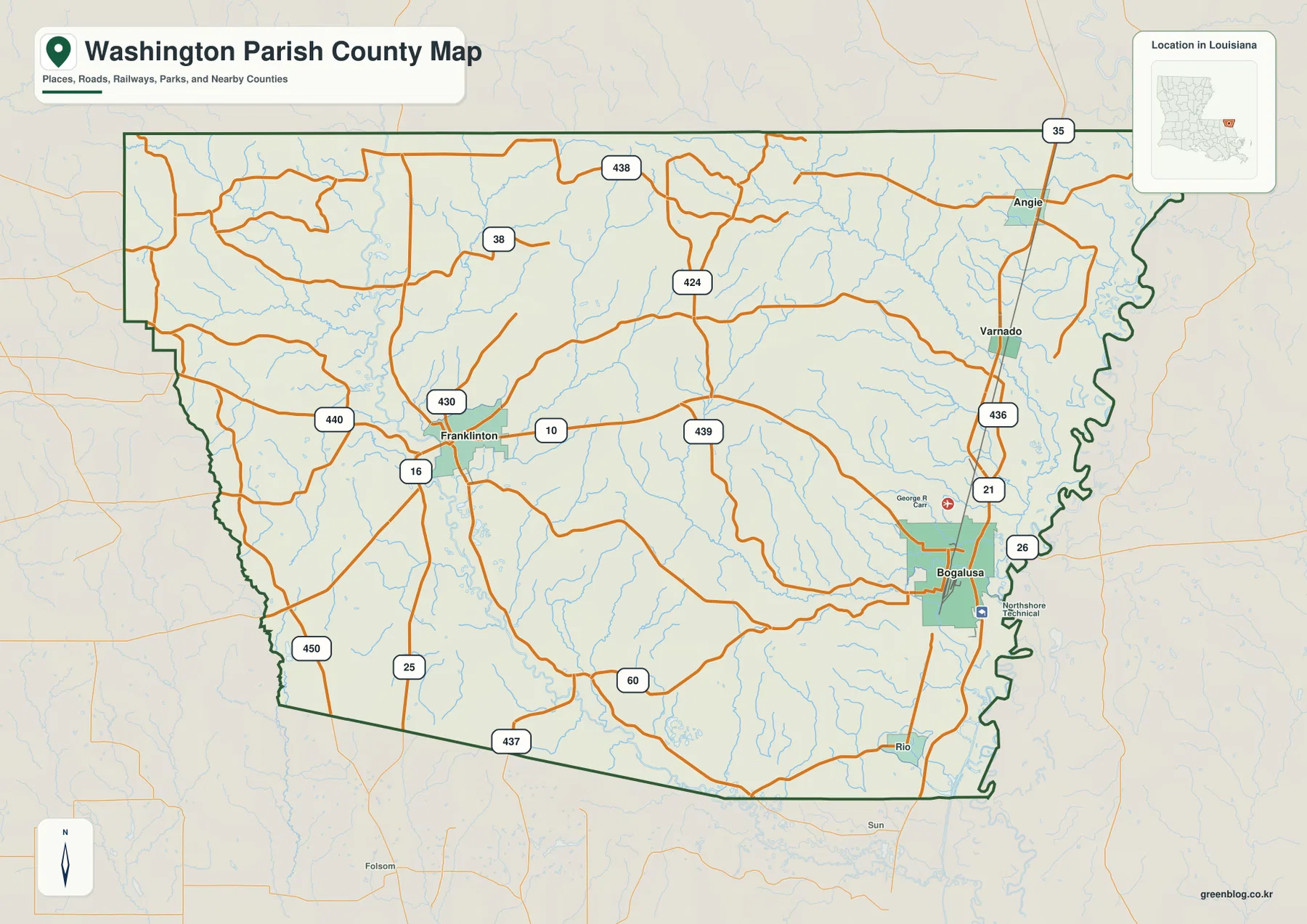
Franklinton anchors the interior where LA 10, LA 16, and LA 25 meet
The general map places Franklinton in the west-central interior where LA 10 crosses east-west and LA 16 and LA 25 provide strong north-south references. LA 430 and LA 440 add local connections around town. There is no interstate or dense metropolitan grid here, so the cluster of state highways around Franklinton is the most useful starting point for understanding the parish.
LA 10 continues east toward the Bogalusa side, while LA 25 and LA 437 head south toward St. Tammany Parish. LA 38 and LA 438 cross the broader rural north. Because the roads are widely spaced and many small streams occupy the gaps, it is easier to begin with Franklinton and add one directional route at a time rather than trying to follow every road at once.
Bogalusa is the largest urban center near LA 21, LA 26, and LA 436
Bogalusa appears as the largest developed area on the eastern side of Washington Parish. LA 21 runs north-south through the city, while LA 26 and LA 436 connect nearby areas. George R. Carr Memorial Air Field and Northshore Technical Community College are also labeled close to the city, making the Bogalusa area visually denser than Franklinton and the surrounding rural communities.
Varnado and Angie continue north of Bogalusa along the same general corridor, and Rio appears to the south. LA 21 provides the easiest road reference through the sequence, with LA 35 joining near Angie. Once these places are located, the northeastern parish reads as a long settlement strip between interior creek country and the major river boundary to the east.
The northern and western parish is a broad rural landscape of local roads and creeks
North of Franklinton, LA 38, LA 424, and LA 438 cross large areas with few major settlement labels. Small streams fill the spaces between roads, giving the area a much more dissected appearance on the water map than on the road view. The northern boundary approaches Mississippi, and local highways bend through a landscape that is more rural than urban.
On the western side, LA 450 and LA 440 lie closer to Tangipahoa Parish, while LA 437 heads south toward St. Tammany Parish. Few large place names appear here, so road numbers and creek valleys become the main orientation tools. Treating Franklinton and the western boundary as one broad rural section makes the map much easier to follow.
The city-connections map gives straight-line distances from Bogalusa
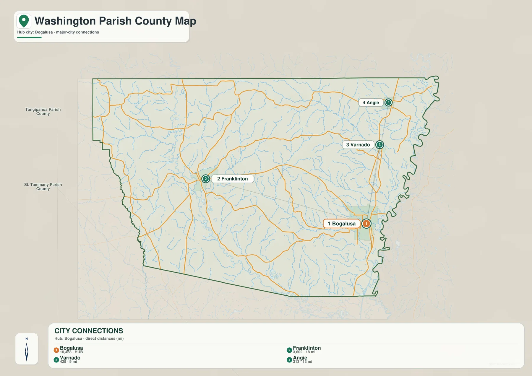
The city-connections graphic uses Bogalusa as its hub and draws direct links to Franklinton, Varnado, and Angie. The legend shows about 18 miles from Bogalusa to Franklinton, 9 miles to Varnado, and 13 miles to Angie. These are straight-line distances between the mapped points, not driving mileage, so actual road distance and travel time depend on the route selected.
The directional pattern is just as useful as the mileage. Franklinton lies west of Bogalusa, Varnado is north, and Angie is farther north along the eastern side. By removing most local roads, the graphic makes relative spacing easy to compare, while the general map remains the better choice for real route planning.
Bogue Chitto River and Tchefuncte River provide the strongest southern and western water references
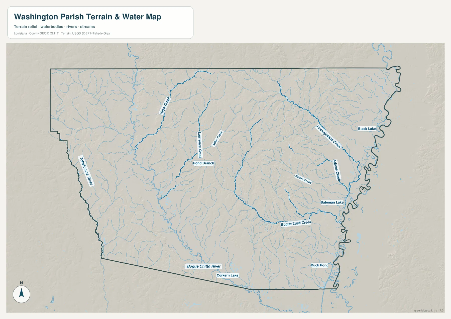
The terrain-and-water map places Bogue Chitto River along the southern side and Tchefuncte River along the west. Louisiana Department of Wildlife and Fisheries includes the Washington Parish reach of Bogue Chitto River and the Tchefuncte River watershed in its Scenic Rivers material. Starting with those larger rivers makes the many smaller interior creeks easier to organize.
Hays Creek, Lawrence Creek, and Miller Creek appear north and east of Franklinton, with Pond Branch between them. None is as dominant as the major rivers, but together they divide the rolling interior into a dense set of narrow drainages. The road map may look relatively open in this area; the water map reveals how many creek valleys actually cross it.
Pushepatapa Creek and Bogue Lusa Creek organize the eastern drainage near Bogalusa
Pushepatapa Creek runs through the northeastern and eastern parish, accompanied by Adams Creek and Peters Creek. Louisiana’s Scenic Rivers material identifies Pushepatapa Creek in Washington Parish and describes its flow toward the Pearl River system. Bogue Lusa Creek appears farther south near Bogalusa, providing a useful local water reference close to the city.
Black Lake and Bateman Lake sit near the eastern side, while Duck Pond appears farther south and Corkern Lake lies near the southern boundary. These water bodies are smaller than the main rivers, but they help distinguish low-lying sections between the creek networks. This terrain-and-water map is intended for general geographic reference only; it does not provide flood-zone status, water depth, navigability, levee condition, or legal property boundaries.
Using Franklinton and Bogalusa as paired anchors simplifies the parish
A practical first pass begins with Franklinton as the west-central anchor and Bogalusa as the eastern anchor. Around Franklinton, LA 10, LA 16, and LA 25 establish direction; around Bogalusa, LA 21, LA 26, and LA 436 do the same. Add Varnado and Angie to the north, then LA 440 and LA 450 on the west and LA 437 on the south, and the larger road pattern becomes clear.
For water features, separate Bogue Chitto River in the south, Tchefuncte River in the west, and Pushepatapa Creek and Bogue Lusa Creek in the east. The general map is best for towns and roads, the city-connections graphic for relative spacing, and the terrain-and-water map for creek valleys and small lakes. Washington Parish is easiest to understand as a rural rolling landscape where settlements are separated by broad stretches of wooded and stream-cut country.
High-resolution JPG files preserve minor roads and creek labels
The downloadable ZIP contains the original JPG files corresponding to the three previews on this page: the general parish map, the city-connections map, and the terrain-and-water map. Each original image is 3638 by 2572 pixels, providing more room to inspect route numbers, place names, creek labels, and smaller lakes than the web preview. The larger format is especially helpful around Franklinton’s local roads and the dense stream network east of Bogalusa.
Choose the general map when Bogalusa, Franklinton, and the main state highways need to appear together. Use the city-connections map when straight-line spacing between the four selected communities is the main question. The water map is the better choice for Bogue Chitto River, Tchefuncte River, Pushepatapa Creek, and the smaller lakes and tributaries. These are general reference maps rather than legal boundary, survey, flood-risk, or real-time navigation products.
Frequently Asked Questions
What is the parish seat of Washington Parish?
Franklinton is the parish seat. Louisiana’s official parish profile identifies Franklinton as the seat, and the supplied map also makes it the strongest west-central road reference around LA 10, LA 16, and LA 25. Bogalusa is the larger city to the east, with Varnado and Angie farther north.
Are the 18-, 9-, and 13-mile labels driving distances?
No. They are straight-line distances from Bogalusa: about 18 miles to Franklinton, 9 miles to Varnado, and 13 miles to Angie. Actual driving mileage depends on the roads and exact starting point, so current navigation information is better for trip planning.
Can the Bogue Chitto River and Pushepatapa Creek map be used for flood or boating decisions?
No. It is a general geographic reference showing Bogue Chitto River, Tchefuncte River, Pushepatapa Creek, Bogue Lusa Creek, and nearby lakes and tributaries. It does not provide flood-zone classifications, water depth, navigability, levee or water-control condition, or legal property boundaries.
Map File Information
The ZIP contains the original high-resolution JPG files corresponding to the general parish map, city-connections map, and terrain-and-water map shown on this page.
- Included Files: parish map JPG, city-connections map JPG, terrain-and-water map JPG
Related Maps
Sources and references
For parish-seat and municipality information, see the Louisiana.gov Washington Parish Profile and Washington Parish Government. Scenic-river information for Bogue Chitto River, Pushepatapa Creek, and the Tchefuncte watershed is available from the Louisiana Department of Wildlife and Fisheries Scenic Rivers page. General boundary data are documented by the U.S. Census Bureau TIGER/Line Shapefiles, and national water-feature data are documented through USGS National Hydrography.
Green Map creates custom-edited map images using open geographic data sources such as geoBoundaries, Natural Earth, OpenStreetMap, and government open data. These maps are edited visual materials, not raw data files, and are provided for education, documents, presentations, and graphic reference.