Tangipahoa Parish in southeastern Louisiana is a long north-south parish stretching from Kentwood near the Mississippi line to Hammond, Ponchatoula, and the Lake Maurepas lowlands. I-55 and U.S. 51 follow much of the same settlement corridor, while Tangipahoa River, Natalbany River, Ponchatoula Creek, and numerous smaller streams cross the interior. At the southern end, Lake Maurepas and Lake Pontchartrain replace the road-dominated landscape with broad water and wetlands. This page explains those visible relationships, and the matching high-resolution JPG map files can be downloaded together in a ZIP.
Amite City is the parish seat. Louisiana’s official Tangipahoa Parish profile and local government sources identify Amite City as the administrative seat, while the supplied map shows Hammond as the largest and most developed urban label farther south. Ponchatoula sits immediately below Hammond, and Kentwood marks the northern end of the main settlement chain. Locating those places first makes the parish’s unusually long shape much easier to understand.
Table of Contents
I-55 and U.S. 51 connect the main settlement chain from Kentwood to Hammond
The general map makes I-55 the clearest transportation reference. It runs down the western side of the parish through or near Kentwood, Roseland, Amite City, Independence, Hammond, and Ponchatoula. U.S. 51 follows a similar north-south pattern and provides another useful road reference through several of the same communities. Together they explain why so many populated places appear in a long vertical sequence.
LA 38 and LA 55 are visible around Kentwood, while LA 10 and LA 16 help locate the Amite City area. Farther south, LA 442 and LA 443 branch east from the central corridor. The road pattern becomes denser around Hammond, where I-12 and U.S. 190 add strong east-west connections. That shift from a simple north-south corridor to a multi-directional highway network is one of the clearest differences between northern and southern Tangipahoa Parish.
Hammond and Ponchatoula form the densest urban area in the southern parish
Hammond is the largest developed area on the supplied map and sits close to the I-55 and I-12 interchange. U.S. 190 continues east toward St. Tammany Parish, and several education-related labels appear around the city. This concentration of highways and developed streets makes Hammond the easiest place to use as a southern transportation reference.
Ponchatoula lies immediately south of Hammond along U.S. 51. LA 22 crosses the area, while U.S. 51 continues farther south toward the lowlands above Lake Maurepas. The two communities appear close enough to form a continuous southern population cluster, but the ranked city map treats them separately, allowing their relative position and prominence to be compared without the full road network.
Amite City, Roseland, and Independence create a continuous central reference
Roseland, Amite City, and Independence appear one after another along the central-western corridor. Amite City is the parish seat, but it is not the largest urban area on the map. Roseland to the north and Independence to the south make the administrative center easy to locate, while I-55 and U.S. 51 tie all three communities into the same larger transportation pattern.
Tickfaw and Natalbany continue the sequence between Independence and Hammond. LA 442 branches east near Tickfaw, and LA 443 provides another eastward connection around Natalbany. These smaller places help show that the distance from Kentwood to Hammond is not an empty gap; it is filled by a nearly continuous series of communities along the north-south road corridor.
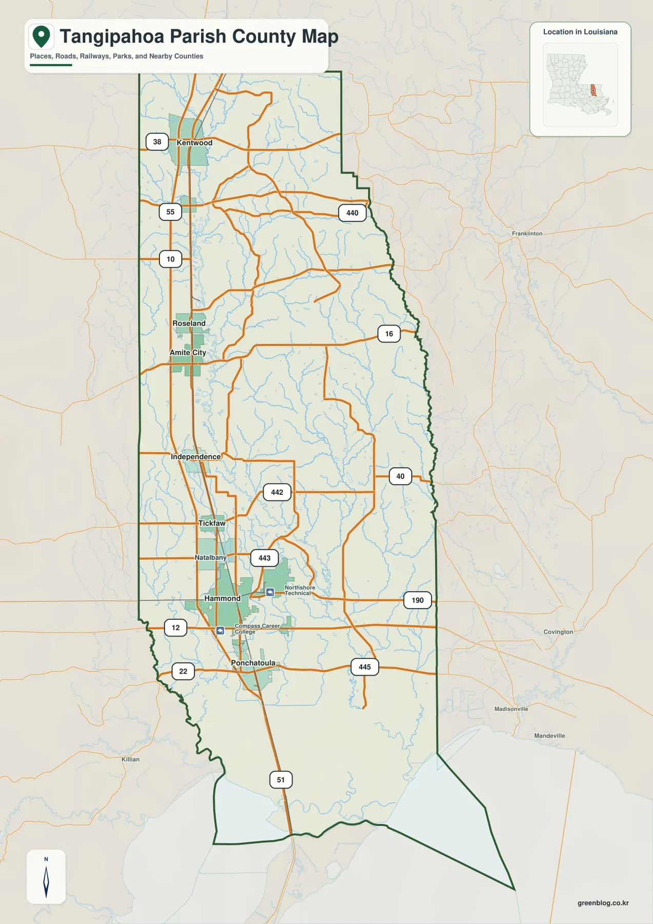
The ranked city index places Hammond first and spreads six selected communities northward
The city-index graphic ranks Hammond number 1, Ponchatoula 2, Amite City 3, Independence 4, Kentwood 5, and Roseland 6. These numbers are rankings, not straight-line or driving distances from Hammond or Amite City. The first two places are concentrated in the south, while the remaining four extend northward along the I-55 and U.S. 51 corridor.
Tickfaw and Natalbany are visible on the detailed parish map but are not included in the six-place ranking. The city graphic should therefore be used as a simplified comparison of selected major communities rather than a complete settlement list. When local roads or smaller place names matter, the general map remains the better reference.
Tangipahoa River provides the strongest northern water reference
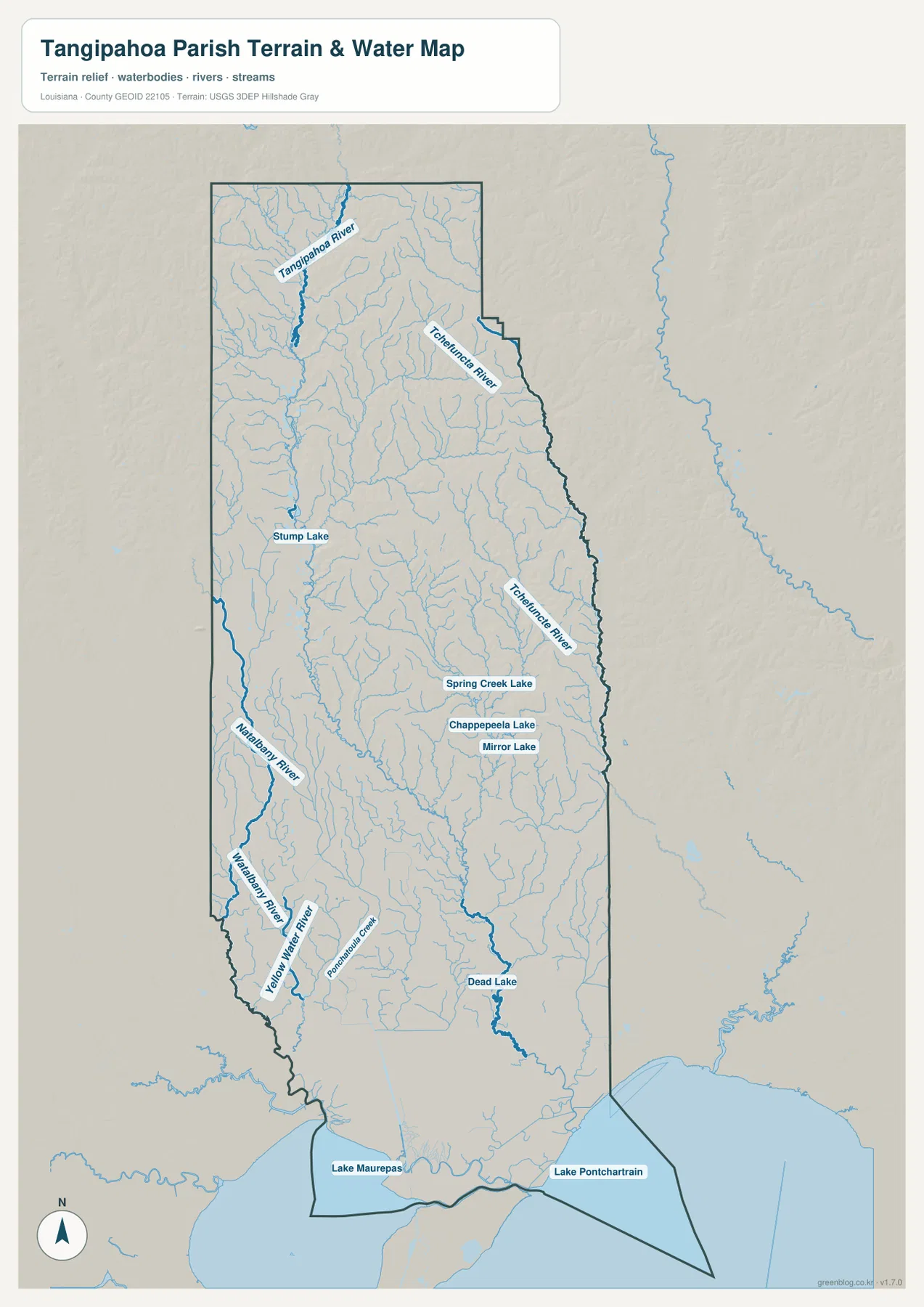
The terrain-and-water map makes Tangipahoa River the most prominent named watercourse in the north. It runs through the upper parish and continues toward the middle, with many smaller tributaries branching around it. On the road map, I-55 provides the dominant north-south reference; on the water map, Tangipahoa River plays a similar role for the natural drainage pattern.
Tchefuncte River is labeled in the northeastern and eastern interior, helping define the side of the parish closest to St. Tammany Parish. Stump Lake appears in the west-central area, while Spring Creek Lake, Chappepeela Lake, and Mirror Lake form a small group farther south and east. These features show that the central parish contains many localized water bodies rather than one large inland lake.
Natalbany River and Ponchatoula Creek lead toward the southern lake lowlands
Natalbany River becomes a major reference on the southwestern side, with Yellow Water River and Ponchatoula Creek nearby. Even though this area is not far from Hammond and Ponchatoula, the water map reveals far more channels than the road view. The southern landscape gradually becomes flatter and wetter as the streams approach the lake country.
Dead Lake is labeled in the southeastern interior, and the parish’s lowest end reaches Lake Maurepas and Lake Pontchartrain. The spaces around those lakes contain extensive wetland drainage rather than a dense street grid. This map is intended for general geographic reference only; it does not provide flood-zone ratings, water depth, navigability, levee condition, or legal property boundaries.
Using Kentwood and Hammond as end points simplifies the long parish shape
A practical first pass begins with Kentwood in the north and Hammond in the south. Place Roseland, Amite City, Independence, Tickfaw, and Natalbany between them, then connect the sequence with I-55 and U.S. 51. Add Ponchatoula and the I-12–U.S. 190 network at the southern end, and the main settlement pattern becomes much easier to remember.
For water features, separate Tangipahoa River in the north, Natalbany River in the southwest, Tchefuncte River in the east, and the Lake Maurepas–Lake Pontchartrain lowlands at the bottom. The general map is best for communities and roads, the city index for the six ranked places, and the terrain-and-water map for streams, lakes, and lowland drainage. Enlarging the original JPG is especially useful for smaller tributary names.
High-resolution JPG files preserve small road and water labels
The downloadable ZIP contains the original JPG files corresponding to the three previews on this page: the general parish map, the ranked city map, and the terrain-and-water map. Each original image is 2572 by 3638 pixels, providing more room to inspect route numbers, community names, river labels, and smaller lakes than the web preview. The larger format is especially useful when viewing the long Kentwood-to-Hammond corridor on one page.
Choose the general map when I-55, U.S. 51, and the major settlements need to appear together. Use the city index for a quick comparison of Hammond, Ponchatoula, Amite City, Independence, Kentwood, and Roseland. The water map is the better choice for Tangipahoa River, Natalbany River, Lake Maurepas, and the smaller lakes and streams. These are general reference maps rather than legal boundary, survey, flood-risk, or real-time navigation products.
Frequently Asked Questions
What is the parish seat of Tangipahoa Parish?
Amite City is the parish seat. On the supplied map it sits between Roseland and Independence along the I-55 and U.S. 51 corridor. Hammond is larger and farther south, but the parish’s administrative center remains Amite City.
Do the numbers 1 through 6 on the city map show distance from Hammond?
No. They are rankings for Hammond, Ponchatoula, Amite City, Independence, Kentwood, and Roseland, not straight-line or driving distances. Actual travel mileage and time should be checked with the general road map and current navigation information.
Can the Lake Maurepas and river map be used for flood or boating decisions?
No. It is a general geographic reference showing Tangipahoa River, Natalbany River, Ponchatoula Creek, Lake Maurepas, Lake Pontchartrain, and nearby water features. It does not provide flood-zone classifications, water depth, navigation clearance, levee status, or legal property boundaries.
Map File Information
The ZIP contains the original high-resolution JPG files corresponding to the general parish map, ranked city map, and terrain-and-water map shown on this page.
- Included Files: parish map JPG, ranked city map JPG, terrain-and-water map JPG
Related Maps
Sources and references
For parish-seat and municipality information, see the Louisiana.gov Tangipahoa Parish Profile and Tangipahoa Parish Government. Road information and maps are available from Louisiana DOTD, general boundary data from the U.S. Census Bureau TIGER/Line Shapefiles, and national water-feature data from USGS National Hydrography.
Green Map creates custom-edited map images using open geographic data sources such as geoBoundaries, Natural Earth, OpenStreetMap, and government open data. These maps are edited visual materials, not raw data files, and are provided for education, documents, presentations, and graphic reference.