Tensas Parish in northeastern Louisiana is a long Delta parish where Newellton, St. Joseph, and Waterproof are separated along a north-south line while the Mississippi River forms a deeply curved eastern edge. Away from those towns, the map is filled with smaller state roads, bayous, oxbow-like lakes, and former river channels. The contrast between the simple settlement chain and the complicated water network is the clearest feature of the parish. This page explains those visible road and water relationships, and the matching high-resolution JPG map files can be downloaded together in a ZIP.
St. Joseph is the parish seat. Louisiana’s official Tensas Parish profile identifies St. Joseph as the seat, while Newellton and Waterproof provide the other major settlement references on the supplied maps. Newellton sits in the north-central area, St. Joseph farther south near the Mississippi side, and Waterproof near the southern end. Locating those three places first makes the parish’s tall shape and its changing road-and-water pattern much easier to understand.
Table of Contents
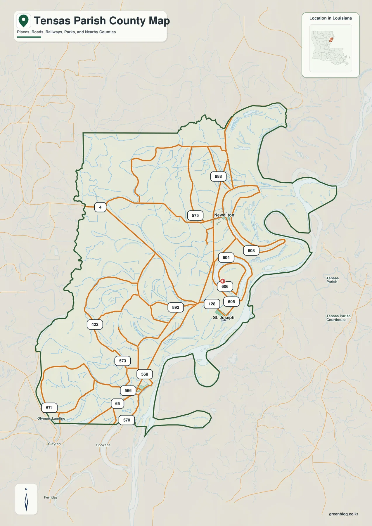
Newellton is the northern road reference among LA 4, LA 575, and LA 888
The general map places Newellton near the north-central part of the parish where several state roads converge. LA 4 enters from the west-central side, while LA 575 and LA 888 provide additional connections around town. There is no interstate or large U.S. highway dominating this section, so the parish road pattern depends on a collection of state routes that bend around drainage features and low-lying land.
East and southeast of Newellton, LA 608, LA 604, and LA 606 approach the Mississippi River side, while LA 605 helps connect the St. Joseph area. Many of these routes change direction rather than following a rigid grid, reflecting the curved water features and irregular eastern boundary. It is easier to read the map by anchoring on Newellton and St. Joseph first and then following individual route numbers through the spaces between lakes and channels.
St. Joseph and LA 128 provide the clearest reference in the central-southern parish
St. Joseph is the parish seat and a useful reference for the central-southern section. LA 128 approaches from the west, with LA 605 and LA 606 nearby and LA 892 visible farther west. The Mississippi River boundary curves dramatically east of town, so the parish outline cannot be understood from compass direction alone. Roads and water features need to be read together.
The area north and east of St. Joseph contains numerous lakes, bends, and former-channel shapes rather than one continuous developed area. That makes the parish seat a small administrative center within a much broader Delta landscape. On the map, St. Joseph is best understood as the point where local roads meet the lowlands around Lake St. Joseph, Lake Bruin, and the Mississippi River corridor.
Waterproof and LA 65 mark the narrowing southern end
Waterproof lies near the southern part of the parish close to LA 65. The boundary narrows noticeably below St. Joseph as the Mississippi River and adjacent channels shape the eastern side. LA 568, LA 566, LA 570, and LA 573 provide additional references in the southern interior, while Olympia Landing and LA 571 help locate the far southwestern edge.
LA 422 curves through the southwest, and LA 892 helps connect the area west of St. Joseph. This is a landscape with few large town blocks, so minor road numbers and named water bodies become important orientation tools. Waterproof is the main settlement reference, but the surrounding roads and Fletchers Lake help explain how the lower parish spreads toward the Mississippi.
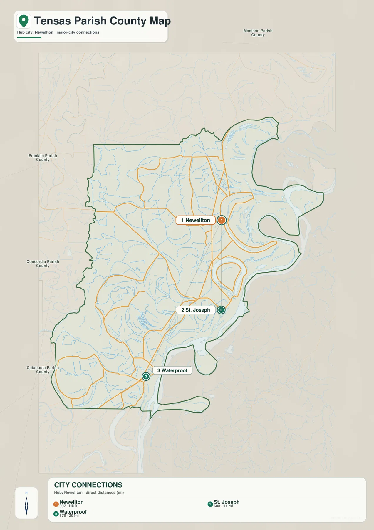
The city-connections map uses Newellton as a hub for St. Joseph and Waterproof
The city-connections graphic places Newellton at the hub and draws direct lines to St. Joseph and Waterproof. The legend shows approximately 11 miles from Newellton to St. Joseph and 20 miles from Newellton to Waterproof. These are straight-line distances between the mapped points, not driving mileage, so actual road distance and travel time will be longer or otherwise different depending on the chosen route.
The direction matters as much as the numbers. St. Joseph lies south of Newellton, and Waterproof is farther south again, so the three communities follow the parish’s long vertical shape. The simplified connection view is useful when the goal is to compare relative spacing without the many state-road labels shown on the detailed parish map.
Mississippi River bends and Lake St. Joseph–Lake Bruin define the eastern lowlands
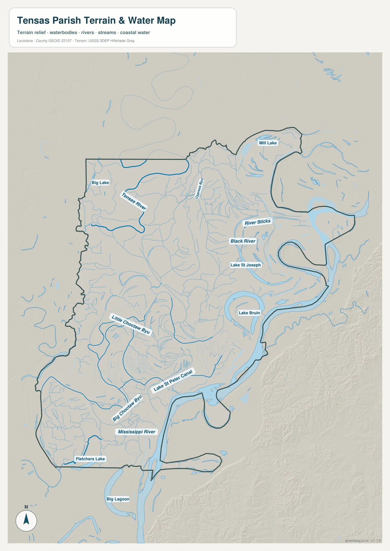
The terrain-and-water map is dominated by the Mississippi River along the eastern and southeastern boundary. The river forms a series of broad bends, and Lake St. Joseph and Lake Bruin sit inside the lowland landscape near those curves. Their shapes and positions help explain why the parish boundary looks so irregular on the road map and why several roads bend sharply instead of following a straight grid.
Black River and River Styx appear north and northeast of St. Joseph, and Mill Lake is labeled farther north. These features are much smaller than the Mississippi main stem, but together they show how many separate water bodies occupy the eastern side. In this part of Tensas Parish, the relationship between present river channels, lakes, and former bends is more important for orientation than settlement density.
Tensas River and the Choctaw bayous organize the western and southern drainage
Tensas River is the strongest named watercourse in the northwestern interior, with Big Lake nearby. Cypress Bayou runs through the north-central area and adds another useful reference between the western drainage and the Mississippi side. Numerous smaller tributaries fill the spaces around them, giving the upper parish a dense Delta drainage pattern even away from the main river.
Farther south, Little Choctaw Bayou and Big Choctaw Bayou form long named channels, while Lake St Peter Canal extends toward the Mississippi side. Fletchers Lake and Big Lagoon appear near the lower end. The water map is intended for general geographic reference only; it does not provide flood-zone status, water depth, navigability, levee condition, or legal property boundaries.
Using the three towns and the Mississippi River together simplifies the parish
A practical first pass begins with Newellton in the north, St. Joseph in the central-south, and Waterproof near the bottom. LA 4, LA 128, and LA 65 then provide broad road references, with smaller routes such as LA 575, LA 892, and LA 568 added only when a specific area matters. This keeps the many local road numbers from obscuring the parish’s simple settlement pattern.
For water features, separate the eastern Mississippi River and Lake St. Joseph–Lake Bruin area from Tensas River in the northwest and the Choctaw bayous in the southwest. The general map is best for communities and roads, the city-connections map for relative spacing, and the terrain-and-water map for oxbow-like lakes, bayous, and river bends. Enlarging the original JPG is especially useful for the smaller channel names.
High-resolution JPG files preserve river bends and minor road labels
The downloadable ZIP contains the original JPG files corresponding to the three previews on this page: the general parish map, the city-connections map, and the terrain-and-water map. Each original image is 2572 by 3638 pixels, providing more room to inspect route numbers, town names, river bends, lake labels, and smaller bayous than the web preview. The larger format is especially useful around Lake St. Joseph, Lake Bruin, and the winding southern boundary.
Choose the general map when Newellton, St. Joseph, Waterproof, and the state-road network need to appear together. Use the city-connections map when direction and straight-line distance between the three towns are the main subject. The water map is the better choice for the Mississippi River, Tensas River, Lake St. Joseph, Lake Bruin, and the Choctaw bayou system. These are general reference maps rather than legal boundary, survey, flood-risk, or real-time navigation products.
Frequently Asked Questions
What is the parish seat of Tensas Parish?
St. Joseph is the parish seat. On the supplied map it lies south of Newellton and north of Waterproof near LA 128, LA 605, and LA 606. Lake St. Joseph, Lake Bruin, and the Mississippi River also provide useful geographic references around the area.
Are the 11- and 20-mile labels driving distances?
No. They are straight-line distances from Newellton: about 11 miles to St. Joseph and about 20 miles to Waterproof. Actual road mileage depends on the route and exact starting point, so current navigation information is better for trip planning.
Can the Mississippi River and Lake Bruin map be used for flood or navigation decisions?
No. It is a general geographic reference showing the Mississippi River, Tensas River, Black River, Lake St. Joseph, Lake Bruin, and nearby bayous. It does not provide flood-zone classifications, water depth, navigability, levee condition, or legal property boundaries.
Map File Information
The ZIP contains the original high-resolution JPG files corresponding to the general parish map, city-connections map, and terrain-and-water map shown on this page.
- Included Files: parish map JPG, city-connections map JPG, terrain-and-water map JPG
Related Maps
Sources and references
For parish-seat and local information, see the Louisiana.gov Tensas Parish Profile. Road information and maps are available from Louisiana DOTD, general boundary data from the U.S. Census Bureau TIGER/Line Shapefiles, and national water-feature data from USGS National Hydrography.
Green Map creates custom-edited map images using open geographic data sources such as geoBoundaries, Natural Earth, OpenStreetMap, and government open data. These maps are edited visual materials, not raw data files, and are provided for education, documents, presentations, and graphic reference.