Calcasieu Parish occupies a broad part of southwest Louisiana, with Lake Charles forming the largest urban center and Sulphur and Westlake closely connected on the west side. Smaller communities such as Vinton, DeQuincy, and Iowa extend the parish far beyond that core. This Calcasieu Parish Map collection shows US 90, US 171, LA 27, the Calcasieu River, West Fork Calcasieu River, Lake Charles, Moss Lake, and the surrounding network of streams and bays. High-resolution map files are available for download in the section below.
The package includes three map themes only: a general parish map, a city-distribution map, and a terrain-and-water map. High-resolution JPG versions of all three can be downloaded together in one ZIP. Lake Charles and Sulphur make useful central anchors, while Vinton in the west and DeQuincy in the north reveal how much larger the parish is than the main urban area.
Table of Contents
Lake Charles, Sulphur, and Westlake form the parish’s densest road network
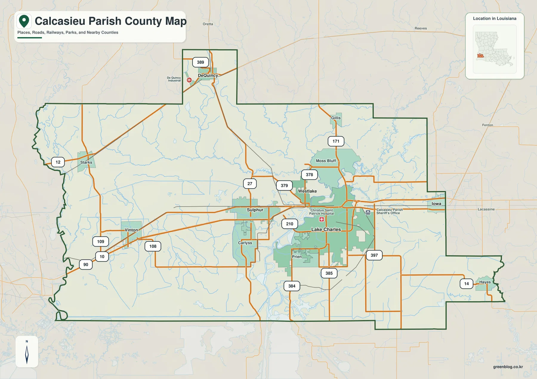
The densest network appears between Lake Charles and Sulphur. US 90 crosses the parish from the Vinton side through Sulphur and Westlake toward Lake Charles and Iowa, while US 171 runs north from Lake Charles toward Moss Bluff and Gillis. LA 378, LA 379, and LA 210 add more local connections around the same central urban area.
Prien is labeled south of Lake Charles, and Carlyss lies southwest of Sulphur. LA 384, LA 385, and LA 397 connect the southern and southeastern rural areas. Iowa sits near the eastern side along the US 90 corridor. Moving away from Lake Charles, the road pattern becomes less dense and smaller waterways become more visible between settlements.
Vinton is the clearest western reference near US 90, LA 109, and LA 108, while Starks lies farther northwest near LA 12. DeQuincy occupies the distinctive northern extension of the parish and is associated with LA 389. These outlying communities show how the parish extends well beyond the Lake Charles–Sulphur corridor.
The Calcasieu Parish Police Jury is based in Lake Charles, and the map also marks major public facilities around the city, including the sheriff’s office and a hospital. The general map is intended for geographic orientation rather than live navigation, current traffic, construction, speed limits, or private access.
Six city markers separate the Lake Charles core from Vinton and DeQuincy
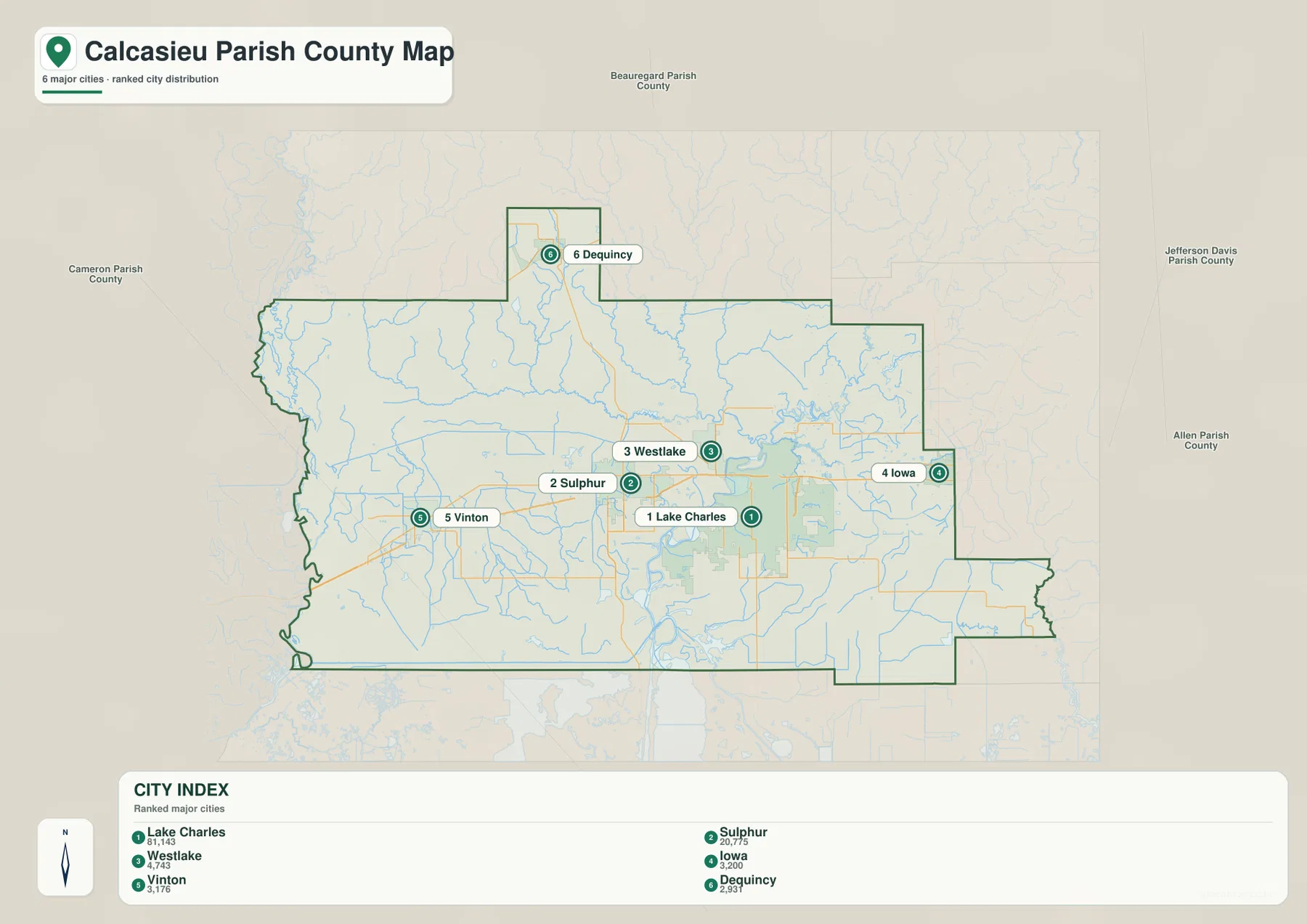
The city-distribution map makes Lake Charles the dominant settlement reference, with Sulphur and Westlake close by to the west. Iowa sits farther east, Vinton farther west, and DeQuincy much farther north. The arrangement shows a concentrated central urban cluster surrounded by smaller towns rather than one continuous built-up parish.
The map index lists six major cities: Lake Charles, Sulphur, Westlake, Iowa, Vinton, and DeQuincy. Lake Charles is substantially larger than the others in the source snapshot, while DeQuincy’s northern location is particularly distinctive. Westlake’s position directly across the river area from Lake Charles also helps explain its close relationship with the central urban core.
Beauregard Parish lies north, Jefferson Davis and Allen Parishes are east and northeast, and Cameron Parish is south and southwest. The western edge reaches the Texas side, with Vinton and Starks among the closest labeled communities. These surrounding references place Calcasieu Parish between the inland southwest-Louisiana corridor and the lower coastal lowlands.
The population figures printed in the city index belong to the source snapshot used to create the map and should not be treated as current official totals. Recent population comparisons should use the U.S. Census Bureau. The main value of this file is the relative placement of the six settlement references.
Calcasieu River, West Fork, lakes, and bays define the parish’s water geography
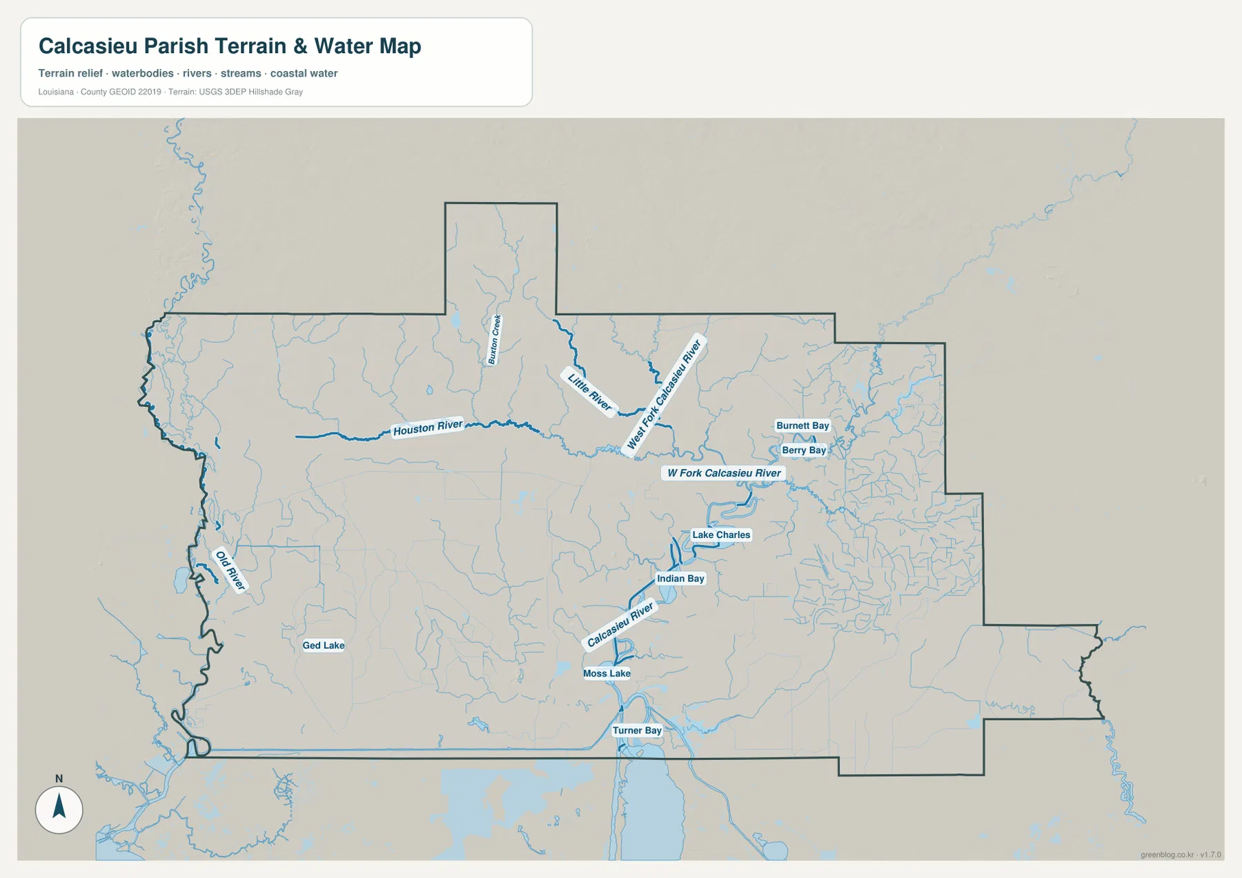
The Calcasieu River is the strongest water reference in the central and southern parish. Lake Charles itself forms a broad water body beside the city, with Indian Bay nearby, and the river continues south through Moss Lake toward Turner Bay. The water map makes the close relationship between the city and the river system much clearer than the road map alone.
North of the urban area, West Fork Calcasieu River and Little River form a major inland drainage system. Houston River approaches from the west, and Burton Creek is labeled farther north. Numerous smaller tributaries branch between them, especially around the area north of Moss Bluff, giving the interior a much denser drainage pattern than a single-channel map would suggest.
Burnett Bay and Berry Bay lie on the eastern side, while Old River and Ged Lake provide western references. These smaller features are not as dominant as Lake Charles or Moss Lake, but together they show how widely water is distributed across the parish. Turner Bay near the southern edge marks the transition toward the lower Calcasieu River and the coastal lowlands beyond.
This terrain-and-water file is a geographic reference, not a flood-insurance map, depth chart, navigation product, legal shoreline record, levee-safety document, or parcel survey. Current flood, boating, access, and property-boundary questions should be checked with FEMA, USGS, or local parish sources.
The Lake Charles core, western Vinton area, and northern DeQuincy corridor feel very different
Lake Charles, Sulphur, and Westlake combine dense roads, public facilities, and major waterways in a compact area. US 90, US 171, LA 210, LA 378, and LA 379 all provide strong orientation, while the Calcasieu River and Lake Charles water body sit immediately beside the urban core. Both the parish government and the City of Lake Charles maintain their primary civic functions here.
Vinton and Starks offer a contrasting western setting. US 90, LA 109, LA 108, and LA 12 remain useful road references, but settlements are smaller and farther apart. Waterways and the irregular western boundary become more important when moving away from the Lake Charles–Sulphur urban area.
DeQuincy is even more separated from the central core because it occupies the parish’s northern extension. LA 389 is the clearest road reference, while Houston River, Burton Creek, and Little River appear as the map moves south toward the main Calcasieu drainage system. Looking at these three parts together gives a much fuller picture of the parish than focusing on Lake Charles alone.
Choose the Calcasieu Parish file by the detail you need
The general map is the best starting point for communities, numbered roads, and the parish outline. The city map is cleaner when the six major settlement references are the main concern. The terrain-and-water map is the strongest choice for the Calcasieu River, West Fork, Houston River, Lake Charles, Moss Lake, and the smaller bays and lakes.
- General map: Use it for Lake Charles, Sulphur, Westlake, Vinton, DeQuincy, Iowa, Moss Bluff, Gillis, US 90, US 171, LA 27, LA 108, LA 109, LA 210, LA 378, LA 379, LA 384, LA 385, LA 389, and LA 397.
- City map: Use it to compare Lake Charles, Sulphur, Westlake, Iowa, Vinton, and DeQuincy and to see the directions of Beauregard, Jefferson Davis, Allen, and Cameron Parishes.
- Terrain and water map: Use it for Calcasieu River, West Fork Calcasieu River, Houston River, Little River, Lake Charles, Indian Bay, Moss Lake, Turner Bay, Burnett Bay, and Berry Bay.
Each original JPG measures 3638 × 2572 pixels in landscape orientation, preserving more small road and waterway labels than the web previews. Keeping the original aspect ratio is recommended for printing. When using all three files, start with Lake Charles and Sulphur, then compare the West Fork to the north with the lower Calcasieu River and Moss Lake to the south.
Frequently Asked Questions
Which map is best for Lake Charles, Sulphur, and US 90?
The general parish map is the best choice because it combines Lake Charles, Sulphur, Westlake, US 90, US 171, LA 27, LA 210, LA 378, and LA 379 in one view.
Where can I see the Calcasieu River and Moss Lake most clearly?
The terrain-and-water map shows Calcasieu River, West Fork Calcasieu River, Houston River, Little River, Lake Charles, Indian Bay, Moss Lake, Turner Bay, Burnett Bay, and Berry Bay. It is a geographic reference rather than a flood, depth, navigation, or legal-boundary map.
Are the six city population figures current?
No. The figures beside Lake Charles, Sulphur, Westlake, Iowa, Vinton, and DeQuincy belong to the source snapshot used for the map. Current population totals and rankings should be checked with the U.S. Census Bureau.
Map File Information
The ZIP contains high-resolution JPG versions of the Calcasieu Parish general map, city-distribution map, and terrain-and-water map. Use the previews to check Lake Charles, Sulphur, Westlake, major roads, the Calcasieu River, Moss Lake, and Houston River before opening the original files.
- Included Files: Use only the versions confirmed in the article and supplied images
- File Type: Use the confirmed download contents
- Intended Use: Printing, education, presentations, and map-based projects
Related Maps
Sources and references
The geographic discussion is based primarily on the supplied Calcasieu Parish maps, with official parish and Lake Charles pages plus federal boundary and hydrography sources used for context.
- Calcasieu Parish Police Jury — official parish government and local information.
- City of Lake Charles official website — official city information and services.
- U.S. Census Bureau TIGER/Line Shapefiles — official geographic boundary and road data.
- USGS National Hydrography — federal hydrography background for rivers, streams, lakes, and bays.
Green Map creates custom-edited map images using open geographic data sources such as geoBoundaries, Natural Earth, OpenStreetMap, and government open data. These maps are edited visual materials, not raw data files, and are provided for education, documents, presentations, and graphic reference.