Rush County lies in west-central Kansas, with La Crosse serving as the county seat and the clearest road reference. Otis, McCracken, Rush Center, Bison, and Liebenthal are spread across a broad rural landscape. US 183 runs through the central part of the county, while K-4 and K-96 provide important east–west connections. Big Timber Creek, Sand Creek, Walnut Creek, and many smaller channels cut long valleys through the uplands. High-resolution map files are available for download in the section below.
This guide follows La Crosse and the surrounding communities across the road, water, and elevation views, with terrain ranging from about 554 to 711 meters. WebP previews are available for quick viewing, and the matching high-resolution JPG files can be downloaded together in one ZIP for printing, classroom work, or offline reference.
Table of Contents
La Crosse anchors the county where central roads meet
La Crosse sits near the middle of Rush County and is the county seat according to the Kansas Historical Society. US 183 runs through the central corridor, while K-4 provides an important east–west route through the La Crosse–Otis side of the county. The city is therefore the easiest reference point for locating the smaller surrounding communities.
Rush Center lies south of La Crosse near the US 183 and K-96 corridor. Otis is farther east along K-4, McCracken is close to the western edge, and Alexander provides a small southwestern reference. Liebenthal sits in the northern rural area away from the main central crossroads.
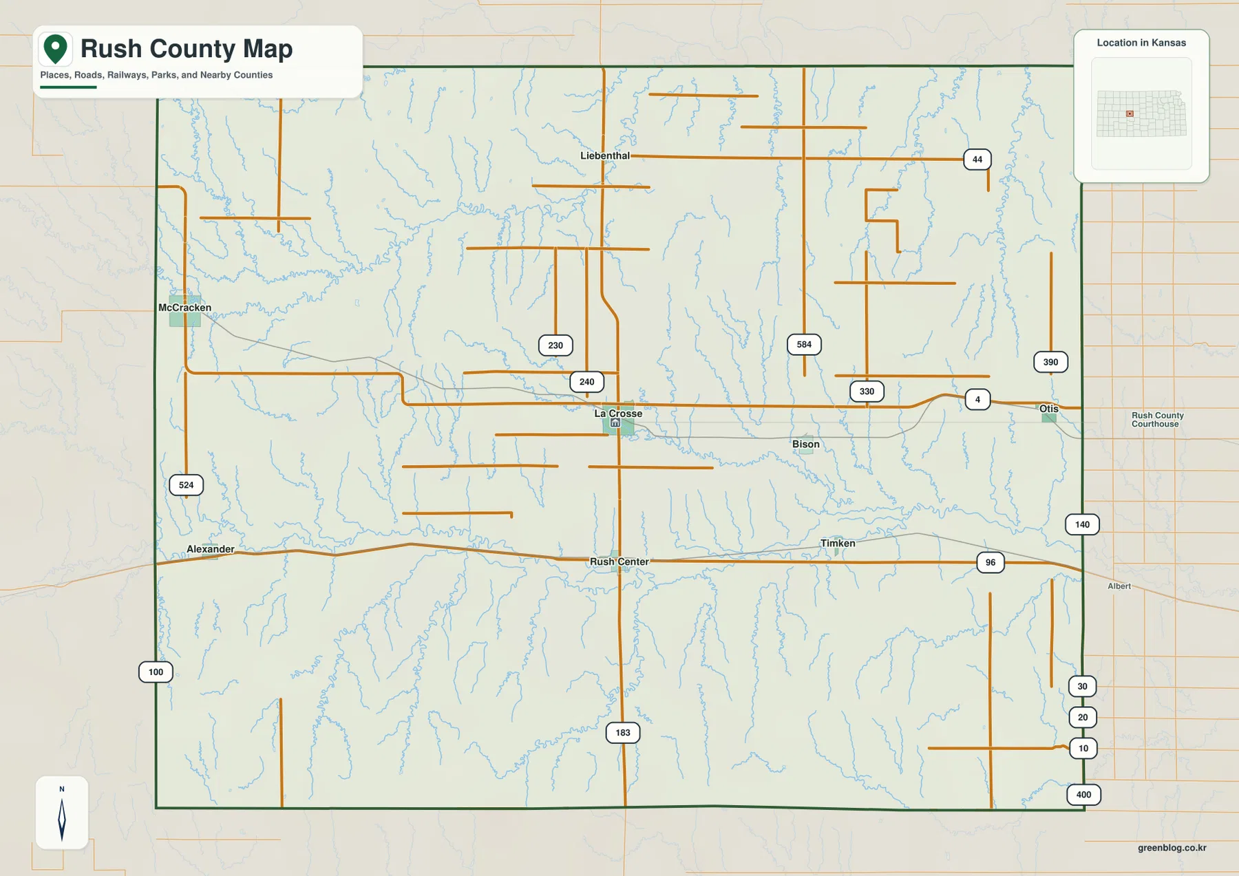
The scattered pattern matters because Rush County does not have one continuous urban corridor. Small communities occupy different road and creek settings, and the long distances between them make the main highways and county roads especially important for orientation.
La Crosse leads the city index, with Otis a distant second
The ranked city panel lists La Crosse at 1,154. Otis follows at 413, McCracken at 200, Rush Center at 179, Bison at 141, and Liebenthal at 87. These are map index values rather than current official population estimates and should not be presented as census counts.
The towns also occupy different parts of the county. McCracken marks the western side, Rush Center lies south of La Crosse, and Bison sits east of the county seat. Liebenthal is isolated in the north, while Otis occupies the eastern K-4 corridor.
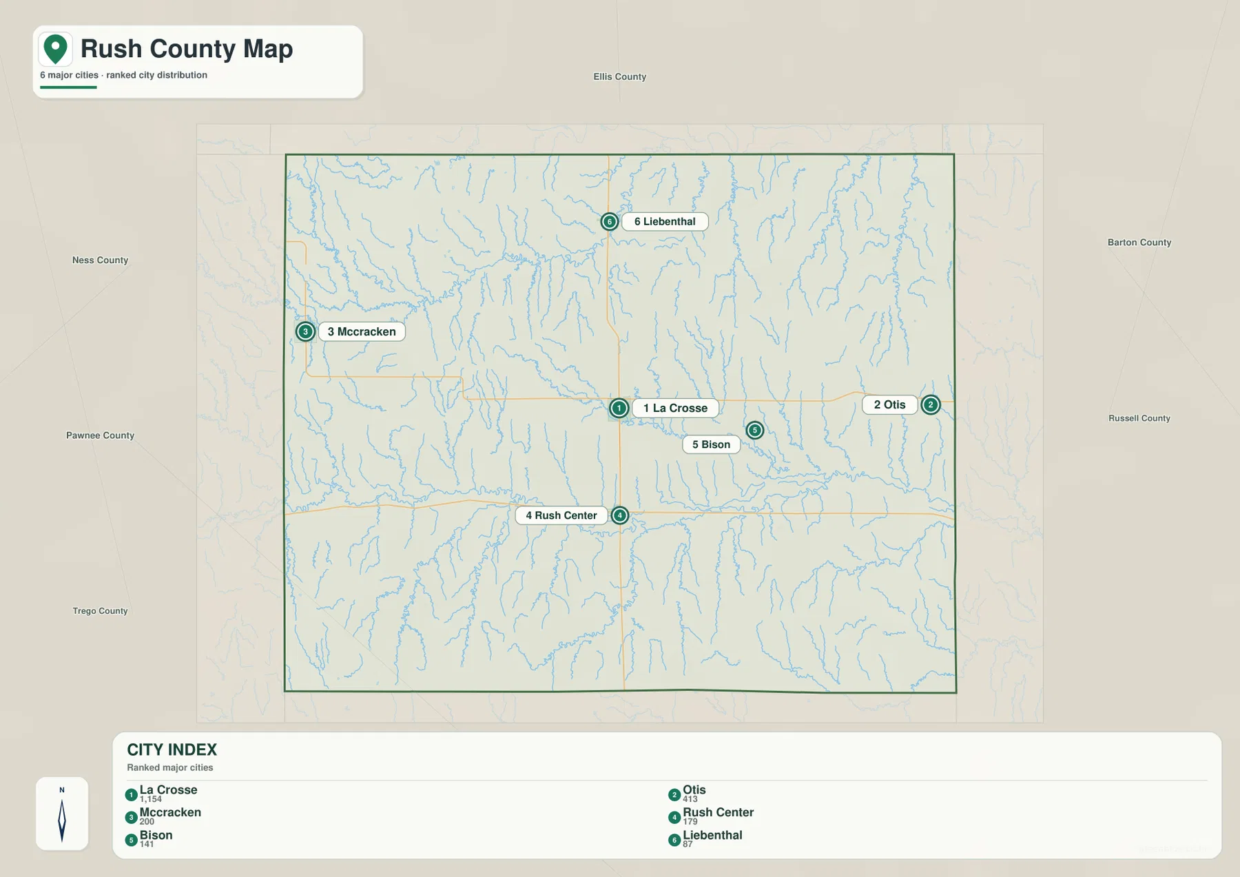
The Kansas Historical Society notes that Liebenthal was one of the communities founded by Volga German immigrants who arrived in Rush and Ellis counties during the 1870s and 1880s. Its northern rural location gives the settlement pattern an important historical dimension beyond the road network alone.
Big Timber Creek, Sand Creek, and Walnut Creek divide the uplands
Big Timber Creek is one of the strongest northern water features on the terrain map. It extends eastward from the Snake Creek side of the county and collects many short tributaries from the surrounding high ground. The result is a long, clearly defined valley through the northern uplands.
Sand Creek creates another major corridor across the central part of the county, with Mule Creek joining the drainage. Farther south, Walnut Creek forms a broad low route across much of Rush County. Old Maids Fork, Sandy Creek, and Otter Creek descend from surrounding uplands toward the central and southern drainage network.
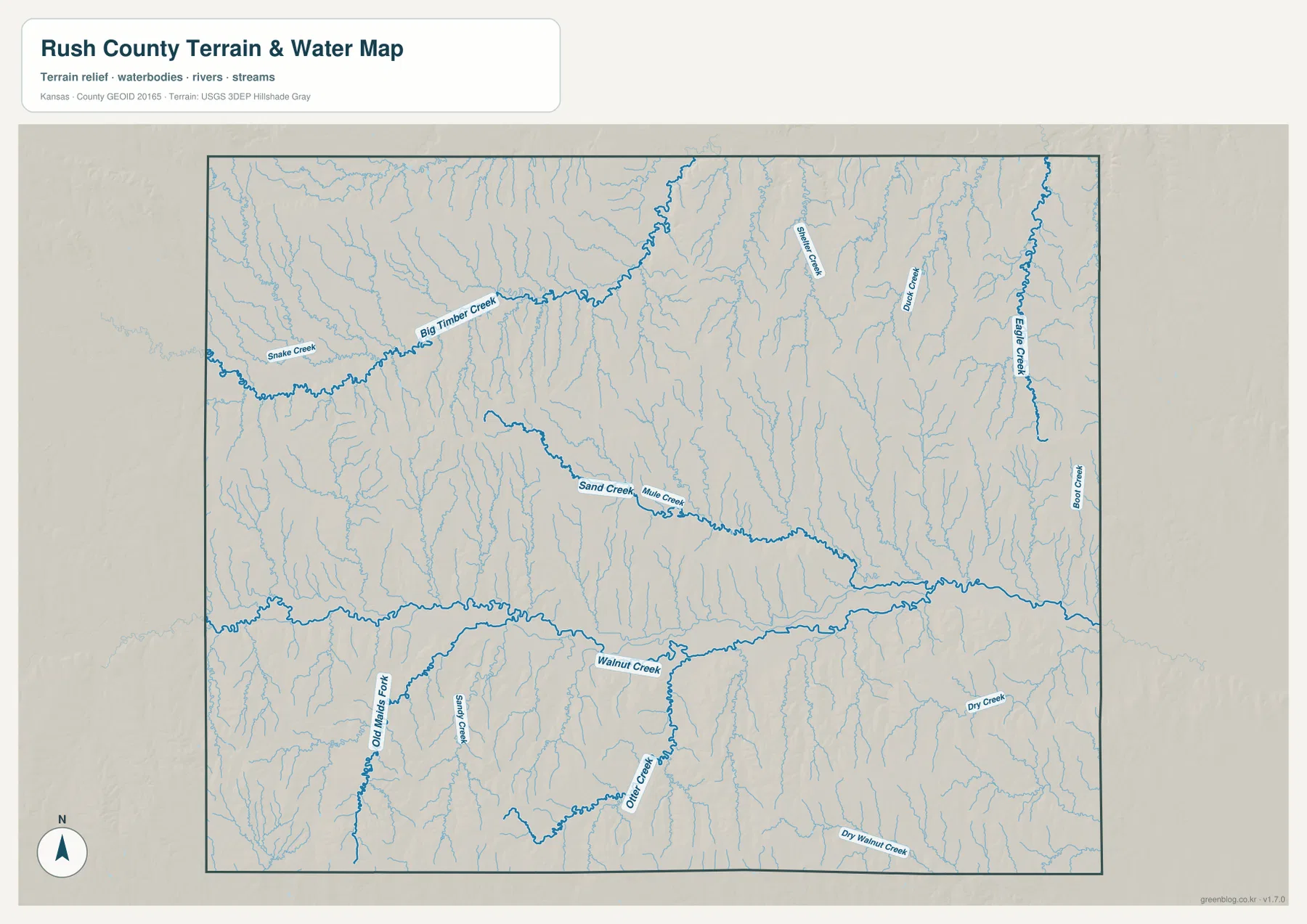
The eastern side contains Banner Creek, Duck Creek, Big Creek, and Boot Creek, while Dry Walnut Creek creates a separate lower corridor in the southeast. The county lacks one dominant large river or reservoir on this map; instead, a dense network of creek valleys provides the main structure.
This water image is intended for geographic reference rather than floodplain, navigation, water-quality, parcel, or legal-access decisions. Stream conditions can change, so current agency information should be used whenever access or safety matters.
Relief from 554 to 711 meters falls from western uplands toward eastern valleys
The elevation surface ranges from about 554 to 711 meters, with a mean near 633 meters. Brown and tan high ground dominates the west and southwest, while greener lower terrain becomes more common toward the east. The Kansas Historical Society places Rush County in the Smoky Hills and Arkansas River Lowlands physiographic setting, which helps explain the county’s mix of upland ridges and lower drainage corridors.
Big Timber Creek, Sand Creek, and Walnut Creek appear as lower bands cutting through the elevated surface. Small tributaries in the west create narrow, deeply incised valleys, while the eastern side contains broader connected low terrain around the creek network.
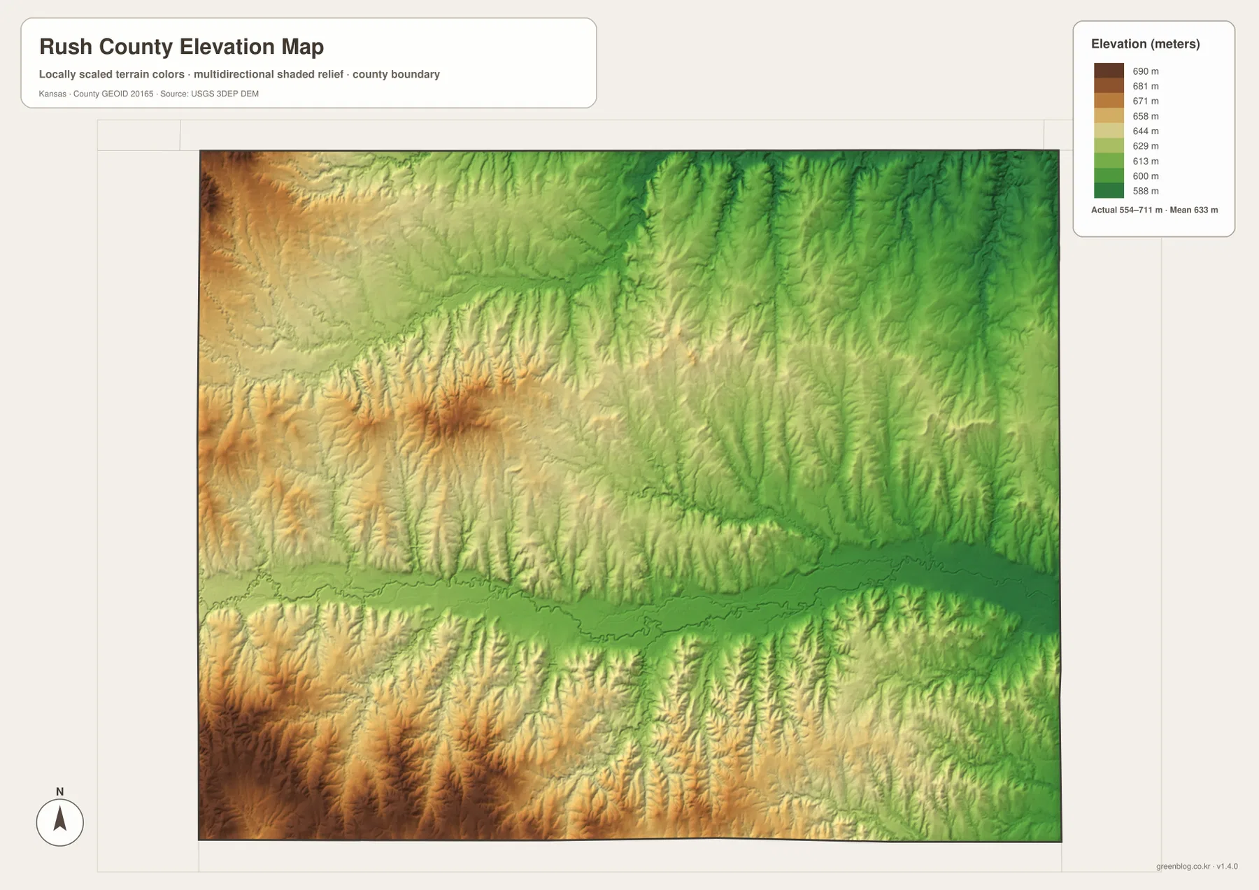
La Crosse and Bison lie closer to the lower central drainage country than McCracken and the western uplands. Rush Center is also influenced by the Walnut Creek system, although higher ground returns toward the southwestern edge. The overall west-to-east decline is one of the clearest patterns on the map.
The elevation surface is generalized for county-scale comparison. It is not survey-grade or engineering-grade measurement and should not be used for parcel elevations, construction grades, drainage design, or legal boundary work.
La Crosse and Rush Center preserve a famous county-seat rivalry
Rush County history gives La Crosse and Rush Center an unusually strong connection. The Kansas Historical Society describes a county-seat dispute that lasted roughly a decade during the 1870s and 1880s. Records moved back and forth, elections and court cases followed, and the Kansas Legislature ultimately confirmed La Crosse as the county seat in 1889.
Today the two communities are connected by the central US 183 corridor. Rush Center’s name still reflects the old contest for the county’s center, while La Crosse remains the administrative seat. That history gives the modern road relationship more meaning than a simple north–south connection.
Liebenthal adds a Volga German settlement story to the northern county
The Kansas Historical Society records an important Volga German migration into Rush and Ellis counties during the 1870s and 1880s. Liebenthal was one of the communities founded during that period and remains a distinctive place name in the northern part of Rush County.
Its location away from the main La Crosse road junction shows how settlement history and transportation did not always follow the same pattern. The northern landscape is dominated by creek-cut uplands, and Liebenthal occupies a much more rural setting than the county seat.
Historic military trails crossed the same uplands and creek country
Kansas Historical Society material notes that the Fort Hays–Fort Dodge and Fort Hays–Fort Larned trails crossed Rush County. Their exact routes should not be confused with today’s highways, but they show that the county has long occupied an important position between western Kansas military and settlement corridors.
Modern travelers use US 183, K-4, and K-96 as the main references. Earlier routes depended much more on terrain, creek crossings, and gradual changes in elevation. Comparing the water and relief maps helps explain why lower valleys and gentler ground mattered when crossing the county before the modern road network existed.
For posters, classroom prints, or presentation slides, use the original JPG files in the download archive rather than enlarging the web previews. Small road labels, creek names, community text, and the elevation legend remain clearer at the higher resolution.
Frequently Asked Questions
Which city is largest on the supplied city index?
La Crosse ranks first at 1,154. Otis is 413, McCracken 200, Rush Center 179, Bison 141, and Liebenthal 87. These are map index values rather than current official population estimates.
Why are La Crosse and Rush Center often discussed together?
The two communities were rivals in a long county-seat dispute during the late nineteenth century. After repeated elections and legal battles, La Crosse became the permanent county seat. Today the two places are connected by the central US 183 corridor.
Can the 554–711 meter elevation image be used for surveying?
No. It is a generalized county-scale terrain image for comparing higher western uplands with lower creek valleys. Parcel elevations, engineering grades, drainage design, and legal boundary work require more precise official data and, where needed, professional surveying.
Map File Information
The archive contains the Rush County, Kansas general county map, city map, terrain-and-water map, and elevation map as original high-resolution JPG files.
- Included Files: Use only the versions confirmed in the article and supplied images
- File Type: Use the confirmed download contents
- Intended Use: Printing, education, presentations, and map-based projects
Related Maps
Sources and references
- Rush County, Kansas official government website — county government and La Crosse information
- Kansas Historical Society: Rush County, Kansas — county-seat rivalry, Liebenthal, military trails, and local history
- Rush County Economic Development — county community and visitor information
- U.S. Census Bureau TIGER/Line Shapefiles — county boundary and geographic reference data
- USGS National Hydrography — creek and water reference data
- USGS 3D Elevation Program — elevation and terrain reference data
Green Map creates custom-edited map images using open geographic data sources such as geoBoundaries, Natural Earth, OpenStreetMap, and government open data. These maps are edited visual materials, not raw data files, and are provided for education, documents, presentations, and graphic reference.