Woodbury County occupies a broad section of western Iowa, with Sioux City dominating the county’s western edge and a much more dispersed group of smaller communities extending eastward. U.S. 20 gives the clearest cross-county reference, linking the Sioux City area with Lawton, Moville, and Correctionville, while Sergeant Bluff and Sloan sit farther south. The maps on this page can also be downloaded as high-resolution JPG files in a ZIP for printing, enlarged viewing, or personal reference. High-resolution map files are available for download in the section below.
The county becomes easier to understand when roads, waterways, and elevation are viewed together. Big Sioux River and Floyd River are important western landmarks, while West Fork Little Sioux River, Little Sioux River, Wolf Creek, Bacon Creek, and Maple River divide the interior into a series of valleys. The elevation map adds another layer: broad low ground appears in the southwest, while ridges and dissected uplands become much more prominent across the central, northern, and eastern parts of the county.
The county makes more sense when the same places are followed across different kinds of information instead of treating each image as a separate product. Sioux City is the best starting point, followed by the U.S. 20 corridor through Lawton and Moville, the southern route toward Sloan, and the river valleys that cut across the eastern half. Once those places are fixed, the contrast between broad western low ground and the more strongly dissected interior becomes much easier to understand.
Table of Contents
Sioux City and the U.S. 20 Corridor toward Lawton and Moville
Sioux City is the most obvious anchor on the general county map. Its built-up area fills much of the western side, with Sergeant Bluff immediately to the south. U.S. 20 heads east from the Sioux City area through Lawton and Moville before reaching Correctionville near the eastern side of the county. Iowa 140 turns north from the Moville area, while Iowa 31 provides a north-south reference through the Anthon area farther east. Along the southern edge, Iowa 141 helps connect the Sloan area with roads leading toward the interior.
This road pattern shows that Woodbury County does not have one continuous chain of towns. The largest urban concentration is packed against the western boundary, but the rest of the county is spread across a wide rural interior. Bronson sits east of Sioux City, Anthon occupies a more easterly position, and Danbury is close to the southeastern side. Sloan lies near the southern boundary, making it a useful reference for travel between the Missouri River lowlands and routes that turn east toward the Little Sioux drainage.
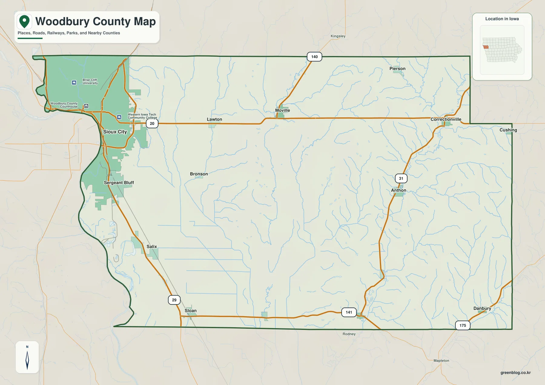
The county boundary itself is worth noticing. The western side follows an irregular river-edge shape rather than a straight north-south line, and the northwest corner includes a narrow projection. The east side is more geometric but still contains several step-like changes. Using the boundary together with the road network helps explain why Sioux City appears to sit at the county’s western gateway while towns such as Correctionville and Danbury feel much farther removed from the main urban center.
A Settlement Pattern Heavily Weighted toward the Western Edge
The ranked city map reduces the county to six major reference points: Sioux City, Sergeant Bluff, Moville, Sloan, Lawton, and Correctionville. Sioux City is by far the largest point shown on the map, with Sergeant Bluff forming a second western cluster. Moville and Lawton sit along the northern U.S. 20 corridor, Correctionville is far to the east, and Sloan stands alone near the southern boundary. The index is useful for comparing relative settlement size and position, but current population figures should be checked against recent Census data when exact numbers matter.
The contrast between Sioux City and the smaller communities is one of the county’s defining geographic features. A visitor looking only at the largest city might expect development to extend continuously eastward, yet the city map shows large gaps between the principal communities. That spacing matters for trip planning, school projects, and regional comparisons because the same road can pass through long rural stretches before reaching the next town. It also makes U.S. 20 especially useful as a visual backbone for understanding the northern half of the county.
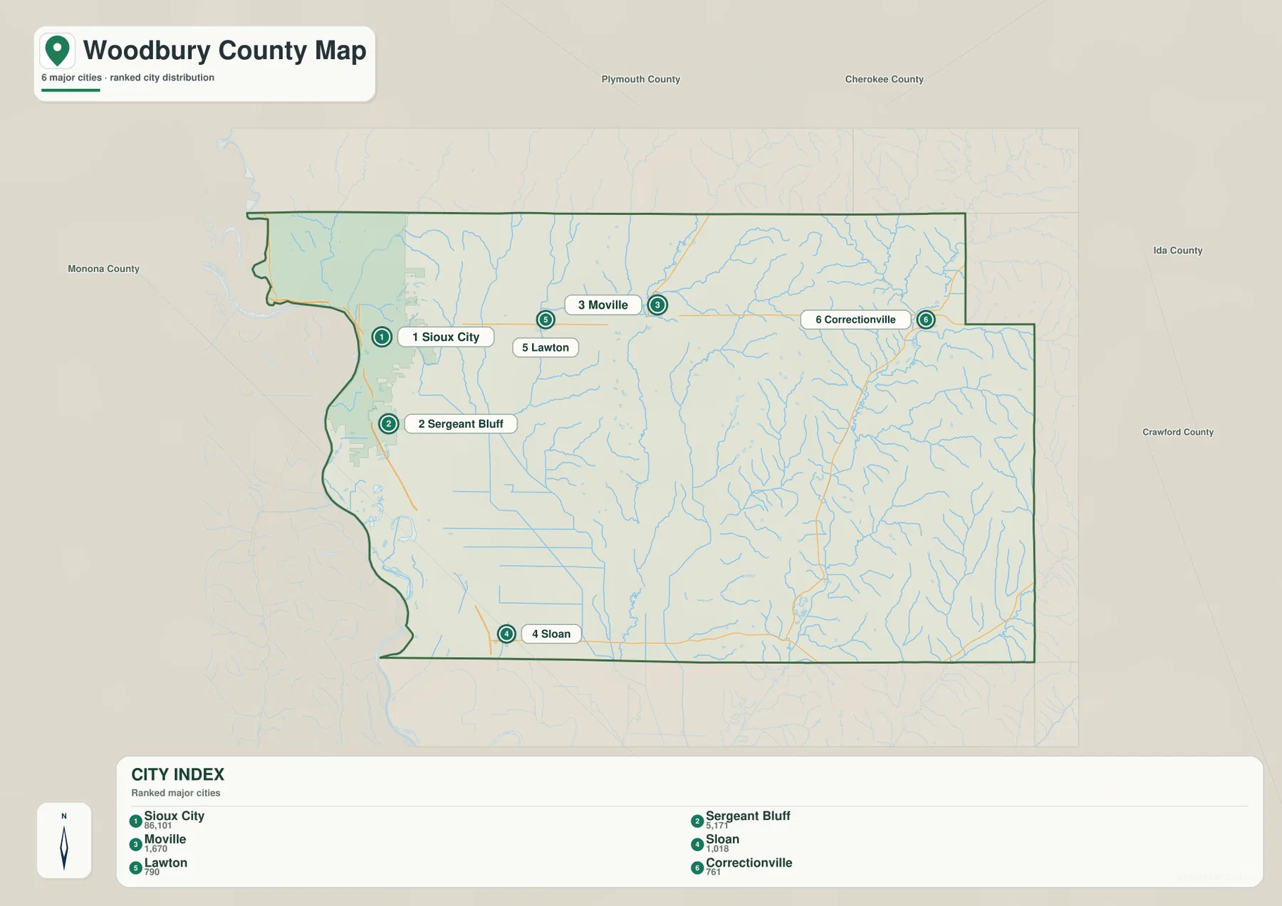
The city map is most useful for relative placement rather than turn-by-turn travel. If connector distances are displayed in this map type, they represent straight-line distance between mapped points rather than road mileage. Actual driving distance can be longer because routes bend around waterways, follow section roads, and pass through different junctions. For that reason, the city map works best as a quick comparison tool, while the general county map is better when the road network itself is important.
Big Sioux, Floyd, and Little Sioux Waterways across the County
The terrain-and-water map highlights several distinct drainage areas. Big Sioux River appears near the northwest edge, and Floyd River bends toward the Sioux City side of the county. Farther south, Browns Lake and Browers Lake stand out in the broad lowland area, with Crystal Cove marked closer to the western boundary. These features create a very different landscape from the densely branched stream valleys visible farther east.
Across the center, West Fork Little Sioux River runs generally north to south and forms one of the strongest interior valleys. Wolf Creek lies to its east, while East Fork Wolf Creek and Little Sioux River occupy the next major set of channels. Bacon Creek is prominent in the northeast, and Maple River appears near the southeastern edge. Many smaller tributaries feed these named streams, creating a repeated pattern of narrow valleys separated by higher ground.
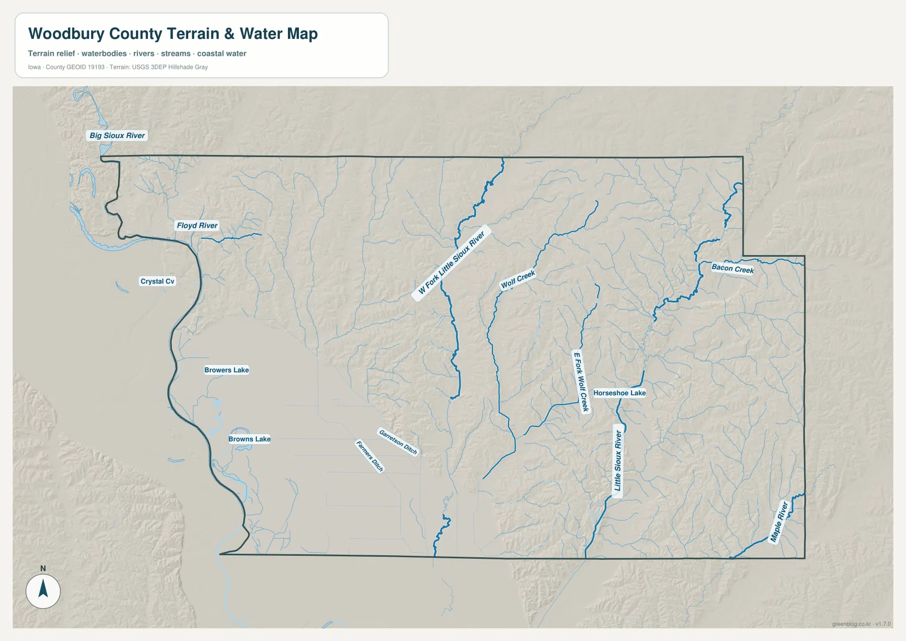
This map is a general water-reference product, not a live flood map, parcel map, legal drainage map, or navigation chart. River levels, flood warnings, access restrictions, and bridge conditions can change and should be checked through current official sources. Its main value is geographic: it shows how strongly Woodbury County is divided by stream valleys and how the broad southwestern lowland differs from the more dissected central and eastern terrain.
Elevation from 319 to 461 Meters: Low Southwest, Higher Interior Ridges
The supplied elevation map reports an actual range of about 319 to 461 meters, with a mean near 374 meters. The lowest colors spread widely across the southwest and along the largest valleys, especially south of Sioux City and toward the Sloan area. In contrast, tan and brown ridges become much more common across the north, center, and east. A difference of more than 140 meters across the county is substantial enough to make the terrain look very different from the simple road grid shown on a conventional map.
The central and eastern portions are not uniformly high. Instead, high ridges alternate with long green valleys. West Fork Little Sioux River and Little Sioux River stand out as low corridors, while nearby tributaries cut side valleys into the uplands. This repeated ridge-and-valley form is especially clear in the northeast and southeast. The result is a landscape where two locations that are fairly close on the road map may occupy noticeably different terrain settings.
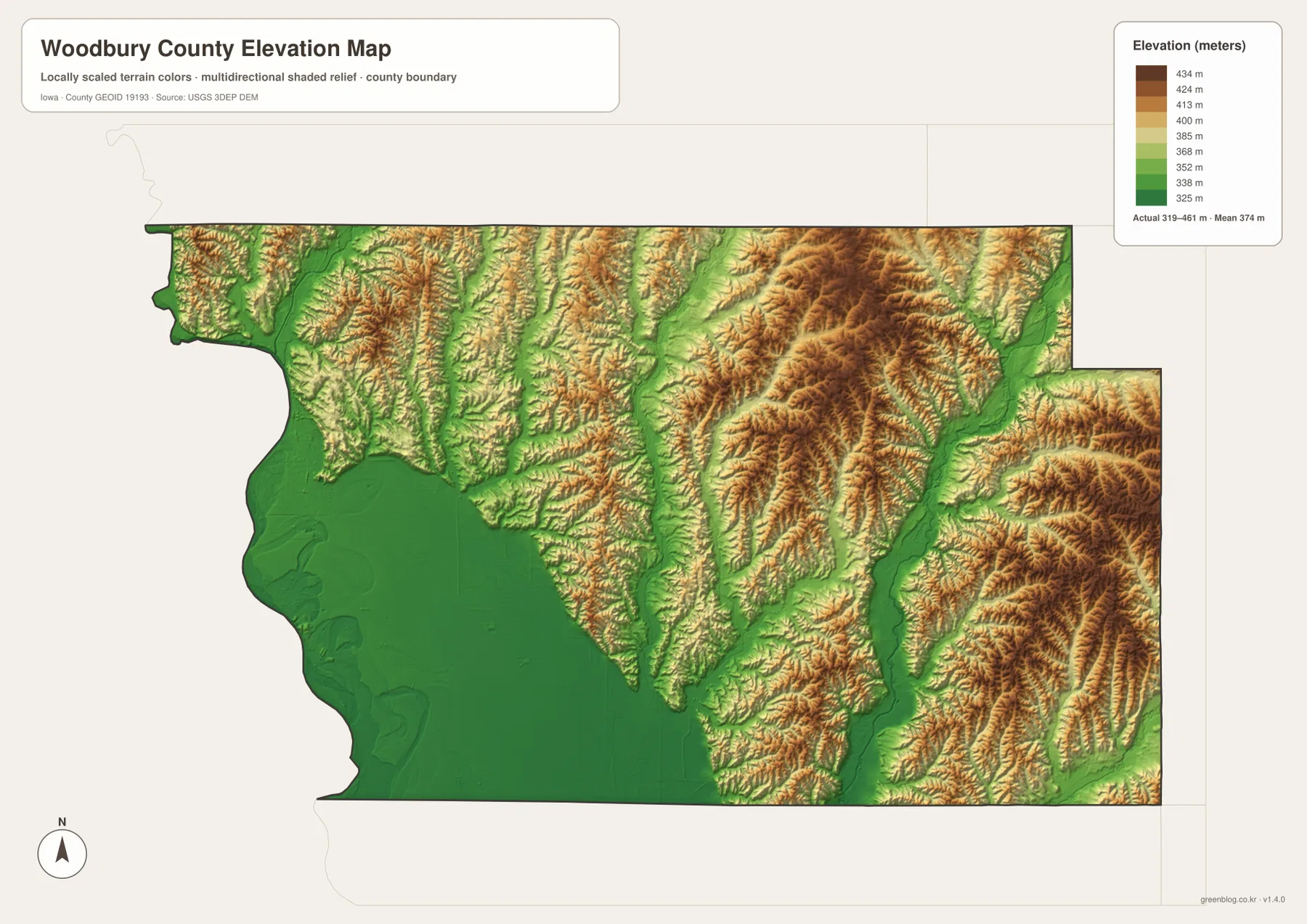
The elevation surface is intended for regional comparison rather than surveying or engineering. It can help identify broad lowlands, valleys, and higher ridges, but it should not be used to establish the exact elevation of a building site, property corner, road grade, or construction project. Pairing it with the water map is particularly useful because many of the green low areas follow the same drainage corridors that appear as named rivers and creeks.
Sioux City Lowlands and the Loess Hills on the Western Side
The western side of Woodbury County contains one of the map set’s strongest local contrasts. Broad low ground extends south of Sioux City, but hills rise quickly along parts of the northern and northwestern edge. Stone State Park, managed by the Iowa Department of Natural Resources, sits on the edge of Sioux City in the Loess Hills and provides a real-world example of this terrain change. The park’s setting helps explain why the western side should not be described simply as flat river country.
Official Woodbury County information also emphasizes that the county contains numerous separate incorporated communities rather than one single urban area. The map set reflects that structure clearly. Sioux City functions as the dominant western center, while the eastern half is defined by smaller towns, farmland, river valleys, and rolling uplands. Looking at I-29, U.S. 20, Iowa 31, Iowa 141, and the major rivers together gives a more complete picture than using any one feature by itself.
Choosing the Best Map for a Woodbury County Question
For basic orientation, begin with the view that keeps Sioux City, Sergeant Bluff, Lawton, Moville, Anthon, Correctionville, Sloan, Danbury, and the main road network together. After that, choose the detail that matches the question. A simplified settlement view is useful for comparing the six ranked communities, while river and creek information becomes more important when a route crosses the interior valleys. If the goal is to understand why the southwest looks broad and open while the east is more rolling, the elevation view adds the clearest explanation.
A cross-county trip provides a good example. If you are comparing Sioux City with Correctionville, first follow U.S. 20 eastward on the county map. Then use the water map to see how the route crosses drainage systems, and check the elevation map to understand why the landscape changes between the broad western lowland and the more rolling interior. For Sloan or Sergeant Bluff, the low southwest and I-29 are more important references; for Anthon or Danbury, Little Sioux tributaries and the eastern ridges become more relevant.
The downloadable original JPG files are useful when labels need to be enlarged or printed. The web images are sized for convenient reading in the article, while the originals preserve more detail for close inspection. For a class assignment, travel notebook, or local research project, it is often easiest to choose one town as a fixed reference and compare that same place across the four maps. That keeps road, water, and elevation information from being confused with one another.
Frequently Asked Questions
Which map is best for comparing Sioux City with the eastern communities?
Start with the general county map because it shows U.S. 20 connecting the Sioux City side with Lawton, Moville, and Correctionville. It also keeps Sergeant Bluff, Sloan, Anthon, and Danbury in the same frame. After that, the ranked city map makes the strong western concentration and the wider spacing of the smaller communities easier to compare.
Where is the lowest terrain in Woodbury County on the supplied elevation map?
The broadest low area appears in the southwest, including land south of Sioux City and toward Sloan. Other low corridors follow the major rivers and creeks through the center and east. The map reports an actual range of about 319 to 461 meters, while many of the northern and eastern ridges are shown in higher tan and brown colors.
Can the terrain-and-water map be used for current flood or property-boundary decisions?
No. It is a general geographic reference showing named rivers, creeks, lakes, and terrain. Current flood warnings, river stages, legal property boundaries, drainage rights, and navigation conditions require current information from USGS, FEMA, Woodbury County, or another responsible agency.
Map File Information
The ZIP contains the high-resolution JPG originals corresponding to the Woodbury County county, city, terrain-and-water, and elevation maps shown on this page.
- File Type: ZIP containing 4 JPG files
Related Maps
Sources and References
For boundary and base geography, see the U.S. Census Bureau TIGER/Line Shapefiles. Water features can be compared with USGS National Hydrography, and elevation context is available through the USGS 3D Elevation Program. Local government and community background is available from the official Woodbury County website, while the Iowa DNR Stone State Park page provides useful context for the Loess Hills landscape on the Sioux City edge of the county.
Green Map creates custom-edited map images using open geographic data sources such as geoBoundaries, Natural Earth, OpenStreetMap, and government open data.
These maps are edited visual materials, not raw data files, and are provided for education, documents, presentations, and graphic reference.