Kosciusko County is easy to recognize by the concentration of lakes around its northeastern towns and by Warsaw’s central position. Warsaw and Winona Lake form the main central urban pair, while Syracuse, Milford, North Webster, and Pierceton provide northern and eastern reference points. For a closer look at lake names, road numbers, and relief shading, you can download the high-resolution JPG ZIP directly from this page. This Kosciusko County Map page brings together the road network, a six-place city index, Lake Wawasee and the Tippecanoe lake system, Tippecanoe River, and a 231–310 meter elevation surface.
Warsaw is the simplest starting point. Route 15 runs down from Milford and Leesburg into Warsaw before continuing toward Claypool and Silver Lake. Route 30 crosses the Warsaw–Winona Lake area and continues east toward Pierceton. Syracuse and North Webster sit among the largest lake clusters in the northeast, while Etna Green, Mentone, Burket, and other small places are spread across the west and south.
Water is the defining visual feature of this county set. Lake Wawasee, Tippecanoe Lake, Webster Lake, Dewart Lake, Big Chapman Lake, and Winona Lake are all clearly labeled, and Tippecanoe River provides a long western-central water reference. Kosciusko County’s parks master plan says the county has more than 100 lakes and identifies Lake Wawasee as Indiana’s largest natural lake. The elevation image adds another layer: broad lower terrain lies to the west and northwest, while the east and northeast rise into a much more pronounced hill belt.
Table of Contents
Warsaw anchors the road map between Route 15 and the east–west Route 30 corridor
Warsaw has the largest developed footprint on the general map and provides the clearest county-wide reference. Route 15 approaches from Milford and Leesburg, passes the Warsaw area, and continues south toward Claypool and Silver Lake. Route 30 crosses the central area near Winona Lake and heads east toward Pierceton. Those two routes create a practical cross-shaped framework for finding the rest of the county.
North of Warsaw, Leesburg sits close to Route 15 and Milford is farther toward the county line. Syracuse lies in the northeast near the Lake Wawasee area, and North Webster is south of Syracuse inside another dense lake district. The road map is easier to remember if the lakes are used as landmarks rather than trying to follow every local road by number.
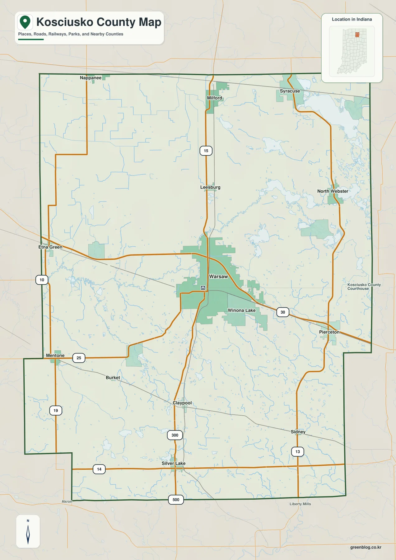
The western side has fewer large developed areas. Etna Green lies near the west-central boundary, Mentone is farther south near Route 25, and Burket is between the Mentone and Claypool areas. Nappanee appears just beyond the upper western boundary. Routes 10 and 19 help organize the west, where settlement labels are farther apart than around Warsaw and the northeastern lakes.
South of Warsaw, Claypool and Silver Lake are close to the Route 15 corridor, while Sidney sits farther east. Route 14 crosses the southern part of the county, and additional numbered roads provide north-south references near the southeast. The stepped southwestern county boundary becomes particularly useful when switching to the water or elevation views, where most settlement names disappear.
The city index separates Warsaw from five lake-country towns to the north and east
The supplied city index highlights six places. Warsaw is printed at 16,768, Winona Lake at 5,080, Syracuse at 3,233, Milford at 1,661, Pierceton at 1,451, and North Webster at 866. Those figures belong to this map edition and should not be treated as live population statistics. What matters most here is the layout: Warsaw is the dominant central place, while the other five entries spread into the north, northeast, east, and immediate southeast.
| Rank | Place | Value printed on map | Position |
|---|---|---|---|
| 1 | Warsaw | 16,768 | Central |
| 2 | Winona Lake | 5,080 | Immediately southeast of Warsaw |
| 3 | Syracuse | 3,233 | Northeast |
| 4 | Milford | 1,661 | North-central |
| 5 | Pierceton | 1,451 | East-central |
| 6 | North Webster | 866 | Northeast-central |
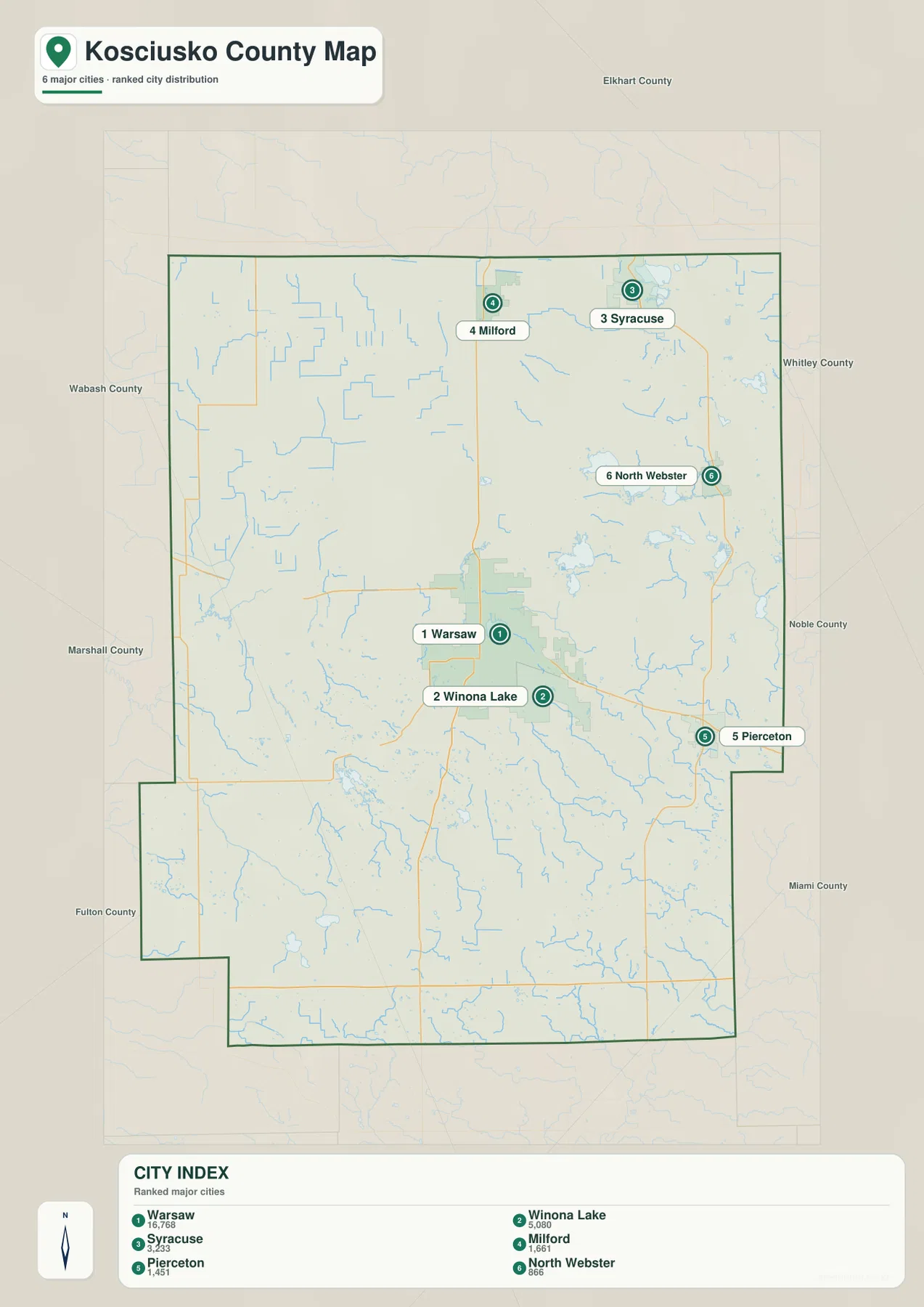
Warsaw and Winona Lake are close together geographically but appear as separate highlighted places. Syracuse and North Webster both belong to the northeastern lake district, yet they are tied to different lake groups and road approaches. Milford sits farther west on the Route 15 side, while Pierceton gives the eastern half its clearest town reference outside the lake cluster.
Several names visible on the general map do not appear in this simplified index, including Leesburg, Etna Green, Mentone, Burket, Claypool, Sidney, and Silver Lake. Use the general map when those smaller places or route connections matter. Use the city index when the task is simply to compare the six highlighted centers and understand how strongly Warsaw dominates the county’s settlement pattern.
Lake Wawasee, Tippecanoe Lake, and Webster Lake define the northeastern water landscape
The terrain-and-water map is unusually lake-rich. Lake Wawasee is the largest visible water body in the northeast. Tippecanoe Lake and Webster Lake sit farther south in another dense lake cluster, Dewart Lake lies to the northwest of those two, Big Chapman Lake is closer to the Warsaw side, and Winona Lake sits just southeast of Warsaw. Because the lake shapes are so distinctive, they can be used as location markers even when road names are absent.
Kosciusko County’s 2023–2027 parks master plan says the county contains more than 100 lakes. It identifies Lake Wawasee as Indiana’s largest natural lake and also names Tippecanoe Lake, Webster Lake, Winona Lake, and Dewart Lake among the county’s notable waters. Those official observations match the supplied map’s strongest visual pattern: the northeast and east-central parts of Kosciusko County are organized as much by lakes as by roads and towns.
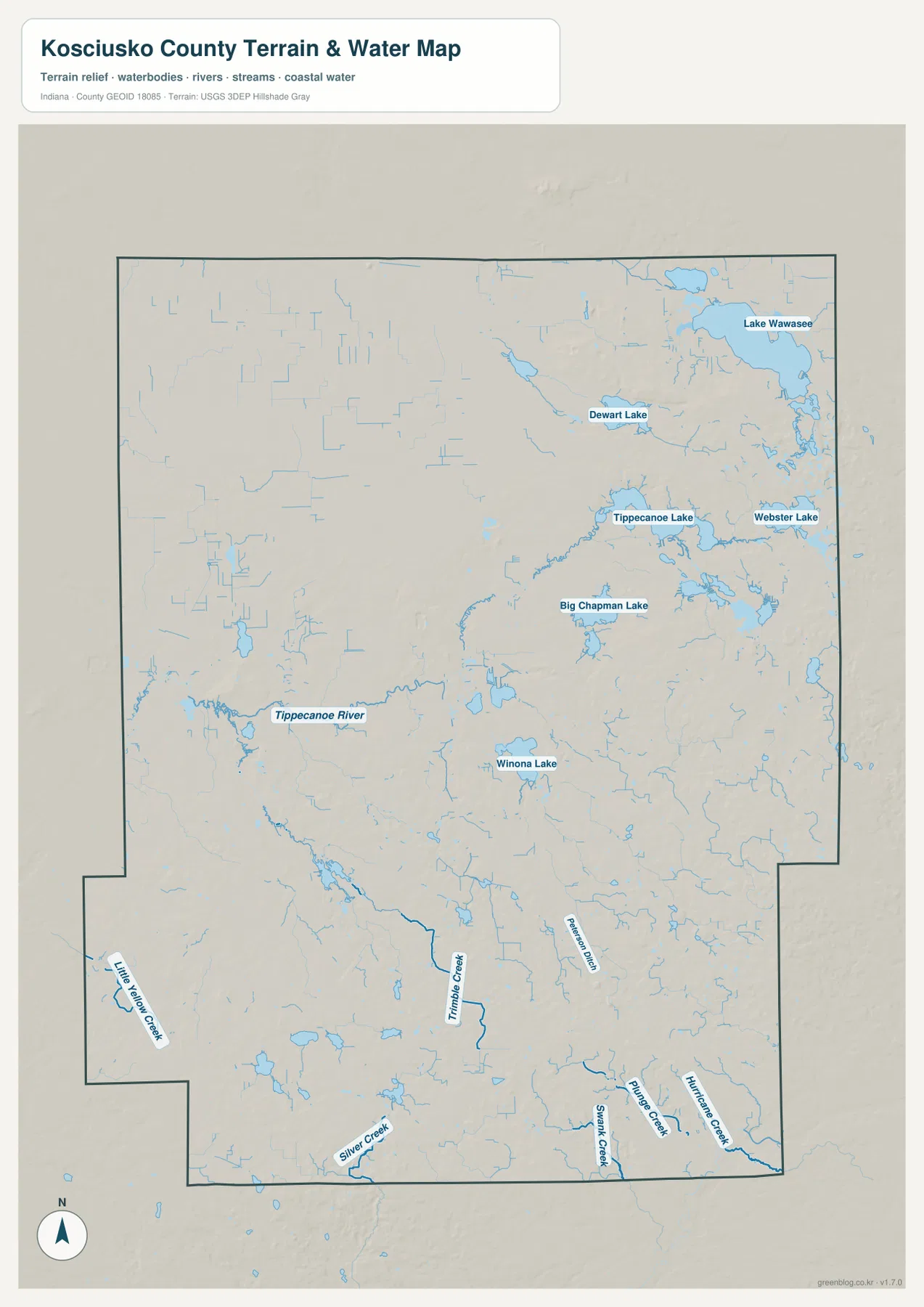
Tippecanoe River provides a different kind of landmark. It bends through the central-western part of the county and is surrounded by numerous smaller channels and wet low areas. Unlike the northeast, where large lake polygons define the map, the Tippecanoe River side is recognized by a winding linear corridor. This makes it useful for distinguishing the western half from the lake-dense east.
South of the major lakes, several smaller named streams become more important. Little Yellow Creek appears near the southwestern extension, Trimble Creek occupies the south-central area, and Silver Creek crosses the lower part of the county. Shank Creek and other channels mark the southeast. These streams help orient the southern half, where the large lake shapes no longer dominate the map.
This map is intended to show where lakes, rivers, and creeks are located. It does not establish flood zones, parcel boundaries, legal water limits, navigation rights, current lake levels, or water-quality conditions. Those questions need current information from the agencies responsible for the specific lake, river, or property.
The 231–310 m elevation surface contrasts western low ground with higher eastern lake country
The elevation legend gives an actual county range of about 231 to 310 meters and a mean of 262 meters. Greens mark lower terrain; tan and brown show progressively higher ground. The broadest low areas occupy the west and northwest. The east, northeast, and southeast contain much more high relief, including several dark-brown ridge groups around and beyond the major lake basins.
The northeastern lake country is not a flat sheet of water surrounded by level land. Lake Wawasee and the Tippecanoe Lake group occupy lower basins, while higher ridges rise around and between them. Short drainage cuts and smaller depressions interrupt the uplands. Comparing the water and elevation views therefore shows why shoreline areas and the terrain between neighboring lakes can differ noticeably in height.
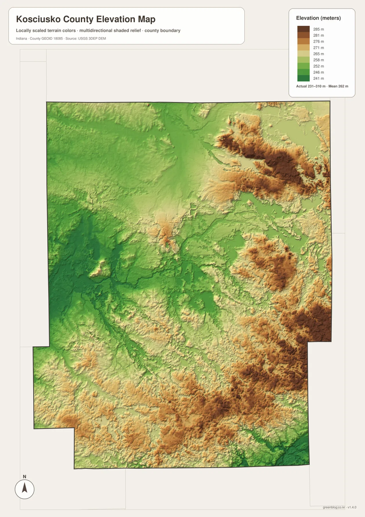
West of Warsaw, the surface is much greener and lower overall. Moving east from the Warsaw–Winona Lake area, the terrain becomes more varied and then rises into the stronger hill groups around the eastern half. Big Chapman Lake and Winona Lake occupy lower basins within this transition. The road map can look fairly simple across the same area, but the elevation view shows repeated changes in local relief.
The south is also varied. Higher ridges appear east of the Claypool–Silver Lake side and become stronger toward the southeastern boundary, while creek valleys remain lower. A useful county-scale reading is to think in terms of three broad elements: western low ground, central lake-and-stream basins, and higher eastern ridges. Individual lake basins and creek valleys then add finer detail inside that larger pattern.
The 231–310 meter values summarize a generalized county elevation surface. They are suitable for comparing broad terrain zones, not for deciding the exact elevation of a parcel, foundation, road grade, or drainage feature. Survey-grade work requires source elevation data such as the USGS 3D Elevation Program or measurements from a qualified survey.
Start in Warsaw, then use the lake shapes to navigate the northeastern half
For roads and settlements, begin with Warsaw and Winona Lake. Follow Route 15 north toward Leesburg and Milford and south toward Claypool and Silver Lake, then use Route 30 to move east toward Pierceton. Syracuse and North Webster are easier to place after the large northeastern lakes have been recognized.
The city index is useful when the goal is to reduce the county to six major highlighted centers. Warsaw dominates the printed values, Winona Lake sits immediately beside it, and the remaining places create northern and eastern reference points. For current population figures, a current official statistical source should be used instead of treating the index as a live demographic table.
For the county’s physical geography, identify Lake Wawasee, Tippecanoe Lake, Webster Lake, and Winona Lake before tracing Tippecanoe River across the central-western side. Then switch to the elevation map and compare the low lake basins with the higher ridges to the east and northeast. That sequence turns the dense collection of blue shapes into a much clearer picture of how water and terrain fit together.
The WebP images on the page are reduced previews. The download archive contains four 2572×3638-pixel JPG originals—the general county map, city index, terrain-and-water map, and elevation map. Those larger files are the better choice for inspecting small lake names, road shields, creek labels, or relief shading at print size.
A practical way to compare the set is to keep Warsaw fixed as the reference point. Locate Warsaw and Winona Lake on the general map, compare their scale on the city index, move to the water map to identify Winona Lake and the larger northeastern lakes, and finish on the elevation view by tracing the lower basins and surrounding ridges. The same method works around Syracuse or North Webster if your interest is focused on lake country rather than the county center.
Frequently Asked Questions
Which lakes are most prominent on the supplied map?
Lake Wawasee is the largest visible lake in the northeast. Tippecanoe Lake and Webster Lake form another major cluster to the south, while Dewart Lake, Big Chapman Lake, and Winona Lake provide additional strong landmarks. The county parks master plan says Kosciusko County contains more than 100 lakes.
Which places lead the supplied city index?
Warsaw is printed at 16,768, followed by Winona Lake at 5,080, Syracuse at 3,233, Milford at 1,661, Pierceton at 1,451, and North Webster at 866. These numbers belong to the supplied map edition rather than a live statistical feed, so current demographic work should use an up-to-date official source.
Can the 231–310 m elevation range be used for exact site elevations?
No. The elevation image gives a county-wide terrain range with a mean of 262 meters and is designed for broad comparison of western lowlands, lake basins, and eastern ridges. Exact parcel, construction, drainage, or engineering elevations require source elevation data or professional survey measurements.
Map File Information
The Kosciusko County ZIP combines the road-and-place map, six-place city index, lake-and-water terrain map, and elevation map as full-resolution JPG originals.
- File Type: ZIP containing four 2572×3638px JPG files
Related Maps
Sources and References
The article is based primarily on the supplied Kosciusko County map set and asset manifest. The following official sources provide county, parks-and-lakes, boundary, hydrography, and elevation context.
- Kosciusko County Government – official county information
- Kosciusko County Parks Master Plan 2023–2027 – official parks, lake, and natural-resource context
- U.S. Census Bureau TIGER/Line Shapefiles – boundary and geographic reference data
- USGS National Hydrography – river, creek, and lake reference data
- USGS 3D Elevation Program – source elevation data
Green Map creates custom-edited map images using open geographic data sources such as geoBoundaries, Natural Earth, OpenStreetMap, and government open data.
These maps are edited visual materials, not raw data files, and are provided for education, documents, presentations, and graphic reference.