Delaware County sits in east-central Indiana, and the map is easiest to understand by starting with Muncie. The county’s largest built-up area spreads across the south-central part of the map, with State Road 32 running west through Yorktown and east toward Selma. State Road 3 heads north from the Muncie area toward Royerton and Eaton, while Albany forms a separate northeastern center and Daleville sits near the southwestern edge. This page explains those road and settlement patterns together with the county’s rivers, reservoirs, and terrain. The four map files shown here are also available as original high-resolution JPGs in a downloadable ZIP.
The county does not form one compact urban cluster. Yorktown lies close to Muncie on the west, but Albany is much farther northeast and Daleville is isolated along the southwestern border. Eaton occupies a northern position along State Road 3, while Selma follows the State Road 32 corridor east of Muncie. That uneven spacing matters when reading the maps because the central city dominates the page visually. Once the road network is reduced to a few major reference lines, the smaller communities define distinct northern, eastern, and southwestern areas.
Water and elevation add a second layer to the county’s geography. The Mississinewa River appears near the northern edge, whereas the White River and West Fork White River occupy the southwestern part of the county. Prairie Creek Reservoir forms a prominent body of water in the southeast. The elevation surface ranges from about 230 to 335 meters, with a mean near 287 meters. Broad western and northwestern areas are lower, while the southeast rises into noticeably higher ground, so the water and elevation maps together reveal a stronger west-to-southeast terrain contrast than the road map alone suggests.
Table of Contents
Muncie organizes the main road pattern without sitting at the county center
On the general county map, Muncie is the clearest place to begin. State Road 32 passes directly through the city and continues toward Yorktown on the west and Selma on the east. State Road 3 runs north from the Muncie area toward Royerton and Eaton, creating a strong north–south reference line. Ball State University is marked in the western part of Muncie, while Ivy Tech Community College appears farther southeast. Those labels are useful orientation points inside a built-up area that would otherwise be difficult to divide into recognizable parts at this scale.
West of Muncie, Yorktown occupies a broad developed area and appears visually close to the city. The road pattern changes farther southwest, where Daleville sits near the county line and the map shows I-69 and State Road 67 nearby. Gaston lies to the northwest rather than along the Yorktown–Daleville direction, so the western half of the county is better understood as several separate branches from Muncie than as a single chain of towns. This distinction is useful when moving between the general map and the simpler city-index map.
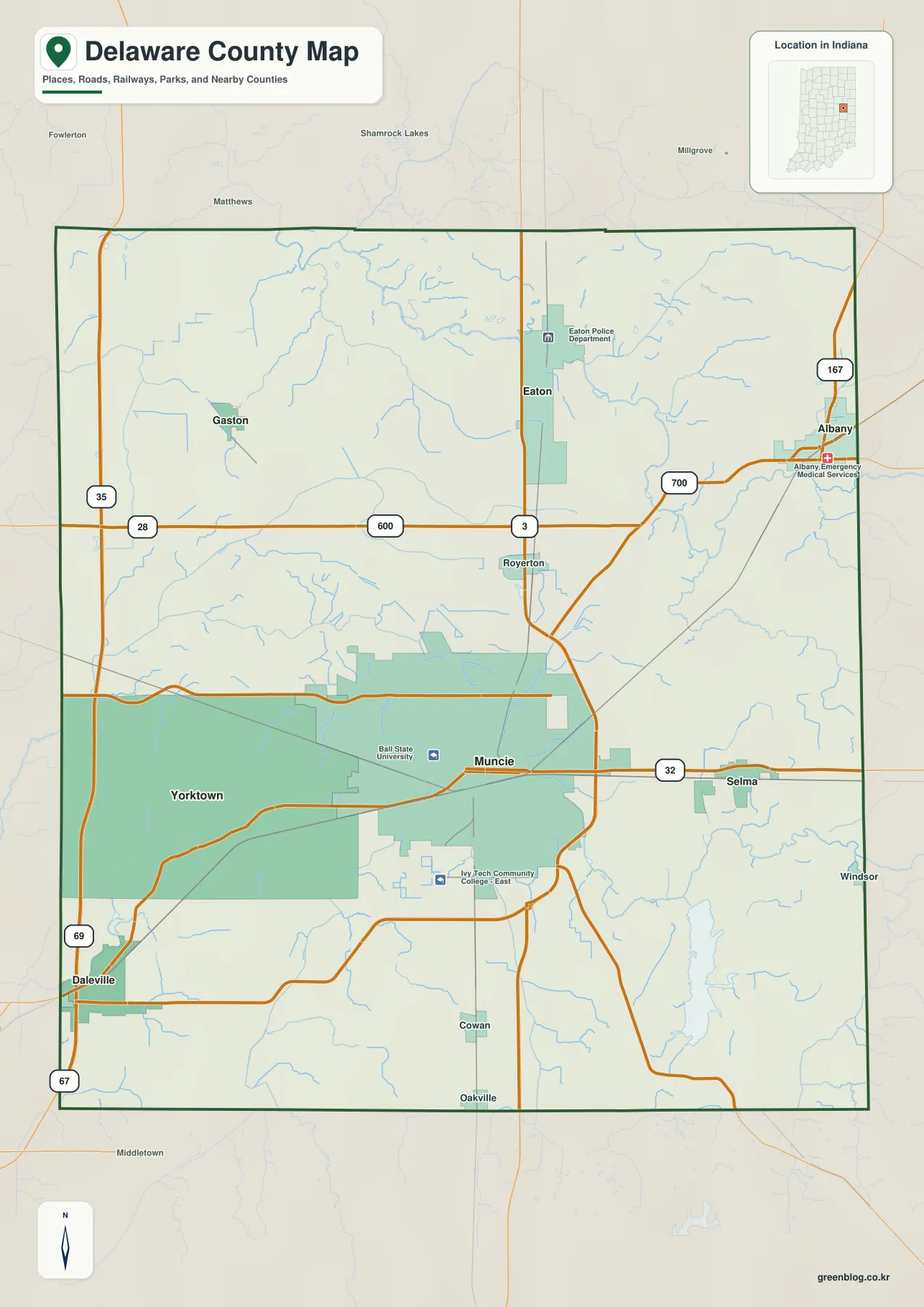
The northeastern corner works differently. Albany is a distinct town near the edge of the county rather than an extension of Muncie, and State Road 67 helps identify its position. Eaton lies west of Albany and closer to the State Road 3 corridor. The northern half contains fewer large built-up areas but many small streams and local roads, so road numbers and nearby place names become more important than continuous development when locating a specific part of the county.
This map is designed for orientation, not turn-by-turn navigation. It does not show live traffic, construction closures, lane restrictions, or reliable travel times. The county outline and shaded built-up areas also should not be used as parcel or legal-boundary evidence. For a trip, address search, or property question, use the map to establish the overall direction first and then confirm the details with current road, address, or county GIS information.
The six-city index stretches from Daleville to Albany around a dominant Muncie
The city-index map removes much of the road detail and highlights six major settlements. Muncie is marked as number 1, followed by Yorktown, Albany, Eaton, Daleville, and Selma. Those numbers are best treated as the map’s city index rather than a complete hierarchy of every incorporated or unincorporated place in Delaware County. The value of the map is the spacing: it makes it easy to see where the main centers sit relative to one another without the visual competition of minor roads and waterways.
Muncie lies slightly south of the county’s middle. Yorktown sits close to it on the west and Selma on the east, producing a compact central east–west group. Daleville breaks that pattern by sitting at the southwestern border. Eaton occupies a northern position, and Albany is farther northeast near the county edge. The result is an asymmetrical settlement pattern in which the largest urban area is south-central while the smaller towns extend toward three different corners of the county.
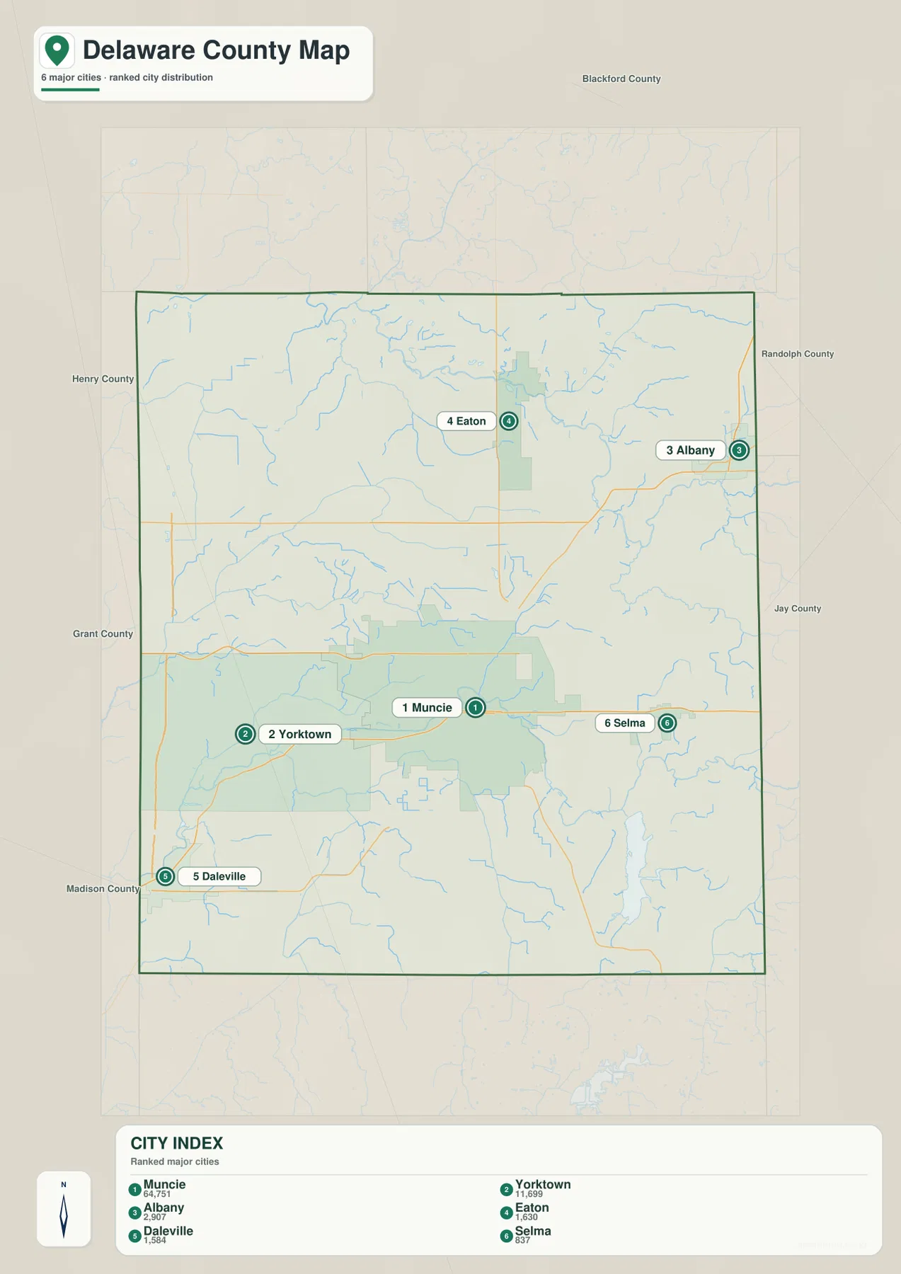
Several names visible on the general map, including Gaston, Royerton, and Cowan, do not appear in the six-place index. That difference is intentional and shows why the two maps serve different jobs. The city map is useful for broad spacing, while the general map restores smaller settlements and roads. After learning the six-city pattern, returning to the general map makes it easier to place those smaller communities within the county rather than treating the index as a complete list.
Northern Mississinewa water and southern White River drainage create two distinct zones
The terrain-and-water map gives northern Delaware County its own identity. The Mississinewa River runs close to the northern boundary, accompanied by a network of smaller channels. Pipe Creek is labeled farther west, while Jackson Lake and Emerald Lake provide additional location markers in the northwestern half. These features sit well away from Muncie’s White River corridor and show that the county’s drainage cannot be summarized by a single river system visible near the largest city.
In the southwest, the White River and West Fork White River occupy broad lowland corridors. Pleasant Run Creek approaches from the west, and the central-southern area includes No Name Creek and Little No Name Creek. Their positions help explain why the terrain west and south of Muncie looks different from the higher southeastern part of the county. Even on a simplified reference map, the streams form long, connected low routes rather than isolated blue lines.
The eastern half adds another set of features. Wilson Creek and Mud Creek are labeled in separate drainage areas, and Prairie Creek Reservoir is the largest obvious water body in the southeast. Burlington Lake lies northwest of the reservoir, with Lake 1 closer to the county’s center. Prairie Creek Reservoir is especially useful as an orientation landmark because its irregular shoreline stands out immediately and can be matched with the higher southeastern terrain on the elevation map.
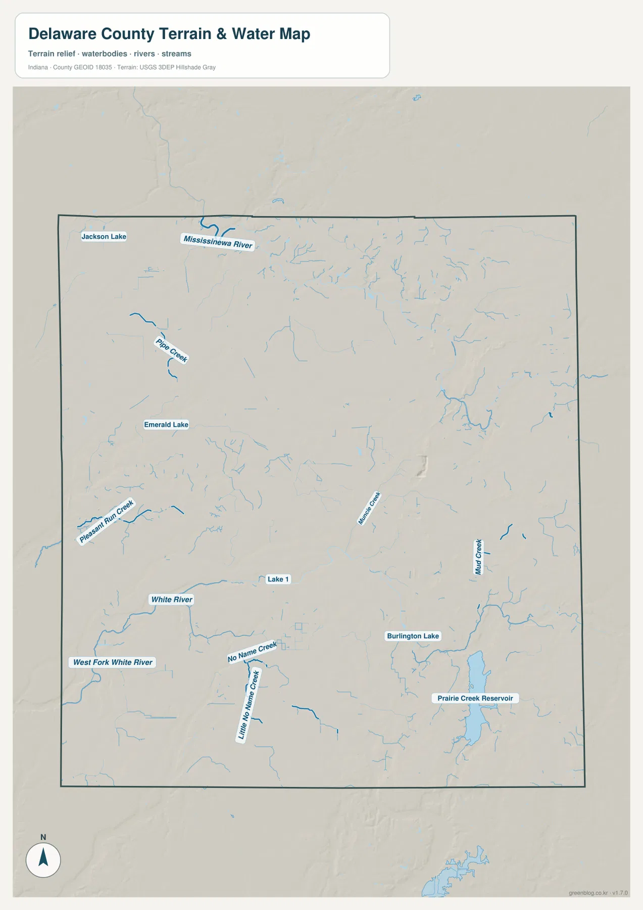
The blue features are reference symbols for water locations, not flood or navigation information. A thicker or more visible line does not establish discharge, depth, water quality, or flood probability. Parcel drainage, flood-insurance zones, boating rules, and current water conditions require dedicated official sources. For this page, the map is most useful for comparing where the Mississinewa River, White River system, eastern creeks, and Prairie Creek Reservoir sit within the county.
Southeastern high ground rises above the broad western lowlands
The elevation map shows an actual range of roughly 230 to 335 meters, with a mean near 287 meters. The western and northwestern parts of Delaware County are dominated by darker green tones, indicating lower ground. Moving east, the colors shift through lighter green and yellow. The strongest orange and brown tones appear in the southeast, where the surface rises well above the broad low areas on the opposite side of the county.
The transition is not a clean diagonal line. Low corridors follow the Mississinewa River in the north and the White River system in the southwest, while narrow stream valleys cut into higher land farther east. In the southeast, the higher surface is broken by small drainage routes around the Prairie Creek area. This combination makes the terrain more useful to read as a set of ridges and shallow valleys than as a simple statement that one half of the county is uniformly higher than the other.
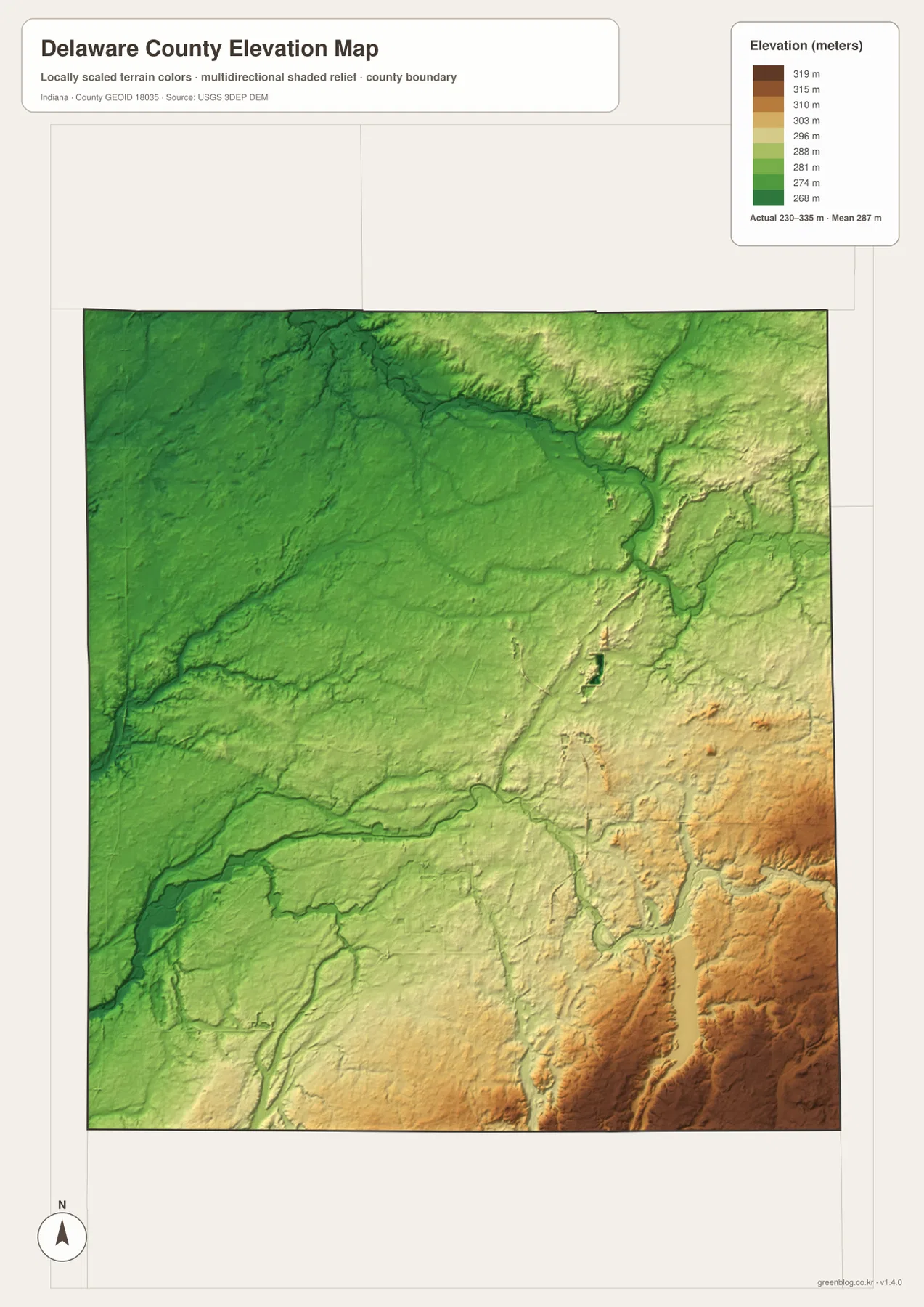
This elevation surface is appropriate for county-scale comparison, not survey work. A single color band covers a range of heights, and small embankments, drainage ditches, or construction grading may not be visible. Building design, engineering, parcel drainage, and exact site elevations require current survey-grade or official elevation data. Here the map’s purpose is to show the county-wide contrast and how the main river valleys relate to lower terrain.
Choosing between the four maps depends on the question you need to answer
For a first look at Delaware County, the general map is the strongest starting point because it combines cities, major roads, waterways, and the county boundary. Find Muncie first, then follow State Road 32 to Yorktown and Selma. From there, State Road 3 leads toward Eaton, while Albany and Daleville define two more distant edges of the settlement pattern. Once that framework is familiar, the city-index map gives a faster, cleaner comparison of the six highlighted centers.
For natural features, the water and elevation maps work best as a pair. Locate the White River or Mississinewa River on the water map, then check the same corridor on the elevation surface to see the lower valley. Prairie Creek Reservoir provides an especially useful southeastern landmark because it sits in a part of the county where the surrounding terrain is generally higher than the west. Matching those features between maps produces a clearer picture than reading either map in isolation.
The WebP images in the article are optimized for quick viewing on the page. If you need to zoom into small road labels, creek names, or terrain shading, the original high-resolution JPGs are more practical. The ZIP below contains the general county map, city-index map, terrain-and-water map, and elevation map, each at 2572 × 3638 pixels. They work well for printing, classroom reference, or offline study, but they do not replace legal boundary, flood, navigation, or engineering documents.
County records confirm Muncie’s role as the administrative center
A 2025 Delaware County government planning document describes the county as part of east-central Indiana and identifies Muncie as the county seat. It also names communities including Albany, Daleville, Eaton, Gaston, Selma, and Yorktown. That official context matches the broad pattern visible on the maps: Muncie is the largest and most central urban reference point, while the smaller communities occupy distinct northern, eastern, western, and southwestern positions.
The county also maintains an official GIS site for more detailed geographic and property information. That resource serves a different purpose from the maps on this page. Use the county GIS when you need precise parcel, address, or administrative information. These four overview maps are better suited to understanding the county’s road structure, settlement spacing, major waterways, and terrain before moving to more specialized data.
Frequently Asked Questions
Which map is best for comparing Muncie, Yorktown, and Selma?
The city-index map is the quickest way to compare their relative positions because it removes most secondary detail. Muncie sits between Yorktown to the west and Selma to the east. After that pattern is clear, switch to the general map to see State Road 32 linking the three areas and to place them within the wider county road network.
How do the northern and southern water features differ in Delaware County?
The Mississinewa River is the dominant named river near the northern edge, while the White River and West Fork White River occupy the southwestern part of the county. In the southeast, Prairie Creek Reservoir forms a major standing-water landmark. Reading the water map with those three zones in mind makes the drainage pattern much easier to follow.
What files are included in the Delaware County map download?
The ZIP contains high-resolution JPG versions of the general county map, city distribution map, terrain-and-water map, and elevation map. Each image is 2572 × 3638 pixels. The files are suitable for close viewing and printing, but they are not legal boundary surveys, flood determinations, navigation charts, or engineering plans.
Map File Information
Download the general county, city distribution, terrain-and-water, and elevation maps of Delaware County as high-resolution JPG files for zooming, printing, and offline reference.
- File Type: JPG
Related Maps
Sources and References
- Delaware County Government, Indiana — county government and local administrative information
- Delaware County Indiana GIS — official county GIS and location tools
- Delaware County ADA Self-Evaluation and Transition Plan 2025 — county location, seat, and community context
- U.S. Census Bureau TIGER/Line Shapefiles — county boundaries, roads, and place data
- USGS National Hydrography — rivers, streams, lakes, and other water features
- USGS 3D Elevation Program — elevation and terrain data
Green Map creates custom-edited map images using open geographic data sources such as geoBoundaries, Natural Earth, OpenStreetMap, and government open data.
These maps are edited visual materials, not raw data files, and are provided for education, documents, presentations, and graphic reference.