Download the Sussex County Delaware Map as a ZIP of high-resolution A3 JPG files, then use the on-page maps to compare the county before choosing which file you need. The clearest way to understand Sussex County is to start near Georgetown and look in two directions: west toward Seaford, Laurel, and the Nanticoke River, and east toward Lewes, Rehoboth Bay, Indian River Bay, Delaware Bay, and the Atlantic coast. The maps on this page separate roads and settlements, major cities, waterways, and elevation so those relationships are easier to follow.
Sussex County covers the southern part of Delaware and has a much broader inland-to-coast span than a quick glance at the state might suggest. Milford and Milton sit toward the north, Georgetown provides a central reference, Seaford and Laurel lie to the west, and Millsboro, Dagsboro, Ocean View, Selbyville, and Lewes lead the eye toward the eastern and southern sides. Because the county is low and crossed by many streams, the water and elevation maps add useful context that the road map alone cannot show.
Table of Contents
Use Georgetown as the pivot between the western towns and the coast
Georgetown is the most convenient place to begin on the general county map. It sits near the middle of Sussex County, where several important roads meet, so the surrounding towns can be understood by direction rather than by memorizing a long list of names. Bridgeville, Seaford, and Laurel lie to the west and southwest. Millsboro and Dagsboro are southeast of Georgetown, with Selbyville farther south. Milton and Lewes are toward the northeast, while Milford appears near the northern edge of the county.
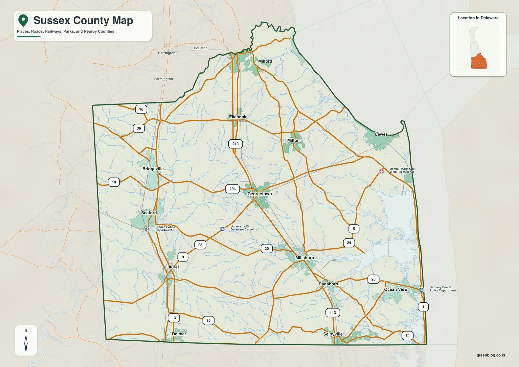
The road pattern reinforces that layout. US 13 serves the western side around Seaford and Laurel, while US 113 runs through Georgetown and continues south toward Millsboro and the lower part of the county. DE 1 becomes the obvious north-south reference near the Atlantic side. Routes 404, 24, 26, and 54 connect the middle of the county with the coast and the southern communities. These lines are useful for understanding regional direction, but the map is best treated as an overview rather than as a substitute for live turn-by-turn navigation.
The county outline also helps explain why Sussex has several different geographic identities within one boundary. Kent County is to the north, Maryland borders the county on the west and south, and the eastern edge opens to Delaware Bay and the Atlantic Ocean. That combination puts inland agricultural and river country, central towns, bay shore, and ocean-side communities within the same county. For a report or classroom handout, the general map is the best single page for introducing all of those relationships at once.
The city map makes the spacing between Milford, Seaford, Georgetown, and Millsboro easier to see
The city map removes most of the highway detail and concentrates on six major places shown in the map index: Milford, Seaford, Georgetown, Millsboro, Laurel, and Milton. The result is a cleaner view of where the county’s larger communities sit in relation to one another. Milford is farthest north among the six, Milton is in the north-central to northeastern area, Georgetown is near the middle, Seaford and Laurel form the western pair, and Millsboro lies southeast of Georgetown.
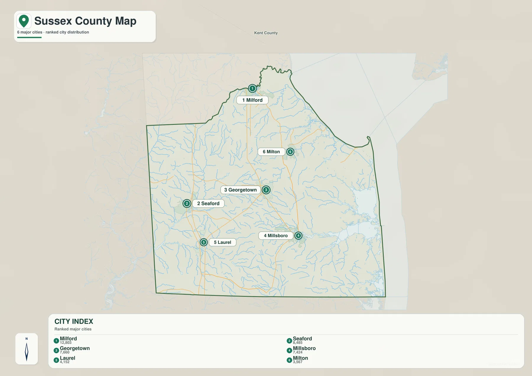
This simplified arrangement is especially useful before moving to the water or elevation maps. Once Georgetown is fixed in the center and Seaford and Laurel are recognized on the western side, the Nanticoke River on the water map is much easier to place. The same is true in the east: Millsboro provides an inland reference before the map reaches Indian River Bay and the Atlantic side. The city view therefore works well as a short orientation step rather than as a replacement for the more detailed county map.
The city index also shows that the major places are not concentrated in a single urban cluster. Instead, the labeled communities are spread across a large county, with meaningful distance between the northern, western, central, and southeastern groups. That distribution helps explain why a Sussex County overview benefits from more than one map: roads answer one set of questions, while water and terrain explain why the eastern and western parts look and function differently.
Nanticoke River on the west and the coastal bays on the east give Sussex two strong water references
The water map shows a county whose drainage is not organized around a single river. On the western side, the Nanticoke River is the strongest named feature and gives Seaford-area geography a clear reference. On the eastern side, the pattern changes completely. Delaware Bay and the Atlantic Ocean form the outer edge, while Rehoboth Bay and Indian River Bay create broad sheltered waters inside the coast. Seeing these features together makes the width of Sussex County much easier to grasp.
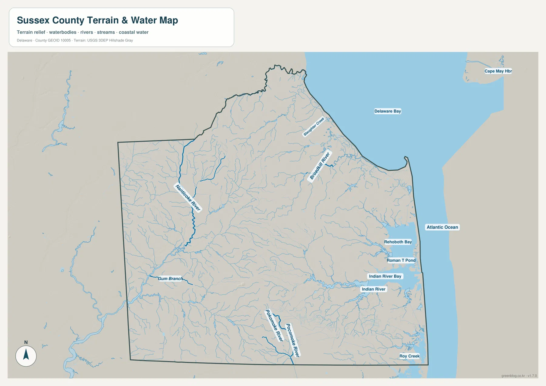
Broadkill River is visible in the northeast as it approaches Delaware Bay, and Indian River runs toward Indian River Bay farther south. Rehoboth Bay lies north of Indian River Bay, close to the Atlantic side, while the Pocomoke River appears near the southern part of the county. Numerous smaller streams branch through the interior. The map therefore explains why the eastern edge is not a simple straight coastline and why inland parts of the county are still closely tied to rivers and drainage channels.
This map is appropriate for locating rivers, bays, and their general relationships, but it should not be treated as a flood-risk, wetland-boundary, or navigation-depth map. Someone checking whether a particular property is in a flood zone needs a dedicated official flood source. For general geography, however, the water map is the quickest way to show the difference between western Sussex County’s river reference and the eastern side’s bay-and-ocean setting.
The elevation map shows a low coastal plain rather than dramatic hills
Sussex County’s elevation map is most useful for relative comparison. The map reports an actual range of roughly -1 to 59 meters with a mean near 9 meters, which immediately shows how low the county is overall. The color ramp stretches those small differences so the pattern is easy to see. Green areas represent the lower parts of the local range, while tan and brown areas mark land that is somewhat higher within the county.
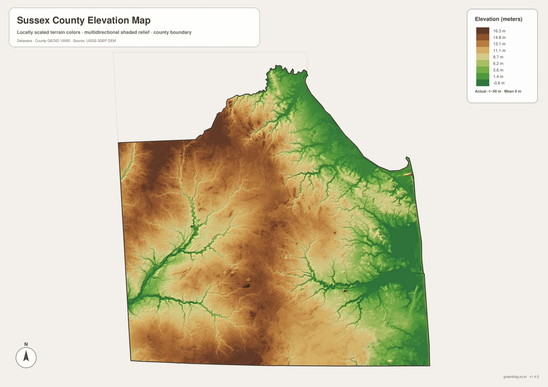
The lowest colors spread widely along Delaware Bay, Rehoboth Bay, Indian River Bay, and the Atlantic side, and narrow lower corridors also follow streams into the interior. Farther west, especially away from the major waterways, tan and brown colors occupy more of the map. The contrast is real but gentle. Sussex County should not be read as a mountainous landscape; the map is showing modest changes across a coastal plain, not steep relief.
Pairing the elevation map with the general map makes the pattern more useful. A route from Georgetown toward the eastern coast can be followed on the road map, then checked against the elevation colors to see the broad transition toward lower ground. The same comparison works around Seaford and Laurel on the western side. Exact elevations for a building, road segment, or parcel require more detailed official data, but the county-wide map is well suited to explaining the big picture.
Choose the map by the question, then use the A3 files for printing or closer comparison
For a first look at Sussex County, start with the general map because it combines Georgetown, the county boundary, major communities, and the road network. Use the city map when the main question is simply where the larger towns sit. Switch to the water map when the Nanticoke River, Rehoboth Bay, Indian River Bay, Delaware Bay, or the Atlantic coast is the subject. The elevation map is the best companion when the discussion turns to low coastal terrain and the slightly higher interior.
The four views are most useful when they are compared rather than treated as interchangeable. A classroom lesson can begin with Georgetown and the main towns, move to the waterways, and then show how low land follows the bays and stream corridors. A report can use the general map for location and add only the water or elevation page that supports the topic. This keeps the final material clear without forcing every label onto a single image.
The WebP images on the page are convenient for quick screen viewing. For printing, worksheets, reports, presentation slides, or offline reference, download the ZIP below. It contains the same Sussex County subjects as high-resolution A3 JPG files, so you can use one map by itself or place several side by side to compare settlements, waterways, roads, and terrain.
Frequently Asked Questions
Which map should I use first to compare Georgetown with Lewes or Ocean View?
Begin with the general county map because it keeps Georgetown, major roads, and eastern communities in the same view. If the explanation needs to show why the coastal side looks different, add the water map for Rehoboth Bay, Indian River Bay, Delaware Bay, and the Atlantic shoreline.
Where are the Nanticoke River and Rehoboth Bay in relation to each other?
The Nanticoke River is on the western side of Sussex County, while Rehoboth Bay is near the eastern Atlantic coast. Their separation across the county is one of the clearest ways to understand how Sussex stretches from inland river country to a very different bay-and-ocean landscape.
Does the elevation map mean western Sussex County is mountainous?
No. The elevation map emphasizes small local differences across a low coastal plain. Much of the western and central interior is somewhat higher than the bay and ocean side, but the map’s stated county-wide range is only about -1 to 59 meters. It is best used for relative terrain comparison, not for identifying mountains or steep slopes.
Map File Information
Download the Sussex County map set as high-resolution A3 JPG files for printing, lessons, reports, presentations, or side-by-side geographic comparison.
- Included Files: general county map, city map, water map, elevation map
Related Maps
Sources and Reference Data
- Sussex County official website
- Delaware DNREC nature preserves
- U.S. Census Bureau TIGER/Line boundary data
- USGS National Hydrography water data
- USGS 3D Elevation Program
Green Map creates custom-edited map images using open geographic data sources such as geoBoundaries, Natural Earth, OpenStreetMap, and government open data.
These maps are edited visual materials, not raw data files, and are provided for education, documents, presentations, and graphic reference.