Download four high-resolution JPG maps of Ogle County, Illinois, in one ZIP from this page, then use the article views to compare Oregon, Rochelle, Byron, Davis Junction, the Rock River, western hills, and elevation. Oregon sits near the center of the county in the Rock River valley, while Rochelle occupies the southeastern corner beside the I‑39 and I‑88 corridors. Byron and Davis Junction extend the settlement pattern north and northeast, while Mount Morris and Polo provide western and southwestern reference points.
The physical landscape changes sharply across the county. High, deeply cut terrain covers much of the west and northwest, but the Rock River creates a long low corridor through Byron and Oregon before continuing south. Leaf River, South Fork Leaf River, Pine Creek, Stillman Creek, Kyte River, and other tributaries cut additional valleys through the uplands. The elevation map reports an actual range of about 194 to 311 meters and a mean near 248 meters.
Table of Contents
Oregon links the Rock River corridor with Rochelle and the western towns
Oregon is the easiest place to begin on the county map. Route 2 follows the Rock River corridor toward Dixon to the south, while Route 64 crosses Oregon and continues east. Byron lies north along the same river system, and Davis Junction is farther east near the Route 72 corridor. Reading the roads together with the river makes the central and northern half of Ogle County much easier to orient.
West of Oregon, Mount Morris occupies the central-western interior, with Leaf River and Forreston farther north and northwest. Polo lies in the southwest near Routes 26 and 52. Rochelle is the opposite case: the southeastern city is tied to I‑39, US 51, I‑88, Route 38, and several local roads, so its transportation pattern is much denser than the western hill country.
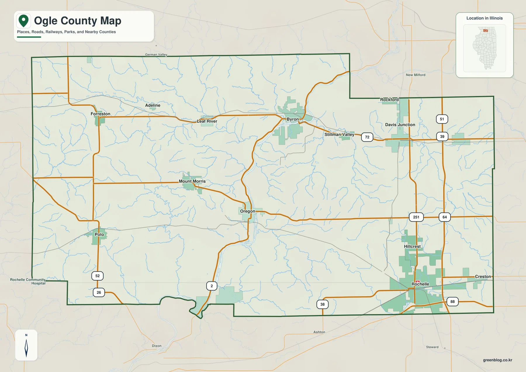
Davis Junction sits near Route 72 and the north-south I‑39/US 51 corridor, while the county boundary steps inward north of that area before widening again to the east. That irregular northeastern shape separates Byron’s river setting from the Rochelle-Davis Junction transportation corridor even though all three are in the eastern half of the county. This map is intended for geographic orientation rather than live navigation, so current traffic and driving times should still be checked with a dedicated road service.
Rochelle leads a six-city ranking split between river, western, and southeastern settings
The ranked city map lists Rochelle at 9,529, Oregon at 3,851, Byron at 3,743, Davis Junction at 2,757, Mount Morris at 2,726, and Polo at 2,495. Rochelle is clearly the largest highlighted place. Oregon and Byron form a second tier of similar size, while the other three communities remain in the mid-2,000 range.
The locations tell a more interesting story than the ranking alone. Rochelle is in the southeast, Oregon near the center, and Byron north of Oregon along the Rock River. Davis Junction lies farther east, Mount Morris west of Oregon, and Polo well to the southwest. The six places therefore represent several different parts of the county rather than one continuous urban strip.
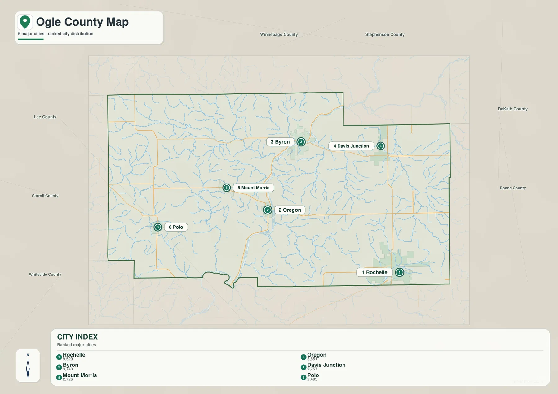
Use the county map after locating the six cities here. It adds Leaf River, Forreston, Adeline, Stillman Valley, Hillcrest, and the road network that explains how the larger places are connected. Rochelle’s interstate access, Oregon’s river-road setting, and the more open western road pattern become much clearer when the two maps are read together.
Rock River carves the central valley while Leaf River drains the northwest
The terrain and water map is dominated by the Rock River. It enters the northern half near Byron, bends south through Oregon, and continues toward the lower county boundary. Illinois DNR places Lowden State Park just north of Oregon along this river and notes that the Rock River flows through about 34 miles of Ogle County. That long river corridor is the best natural reference for connecting the water, settlement, and elevation maps.
Northwest of the Rock River, Leaf River and South Fork Leaf River form a separate network, joined by streams such as Mud Creek and Mill Creek. Lake Louise sits in the north-central area between the Leaf River country and the Rock River valley. Elkhorn Creek appears farther west, while Pine Creek cuts a long valley through the west-central and southern interior.
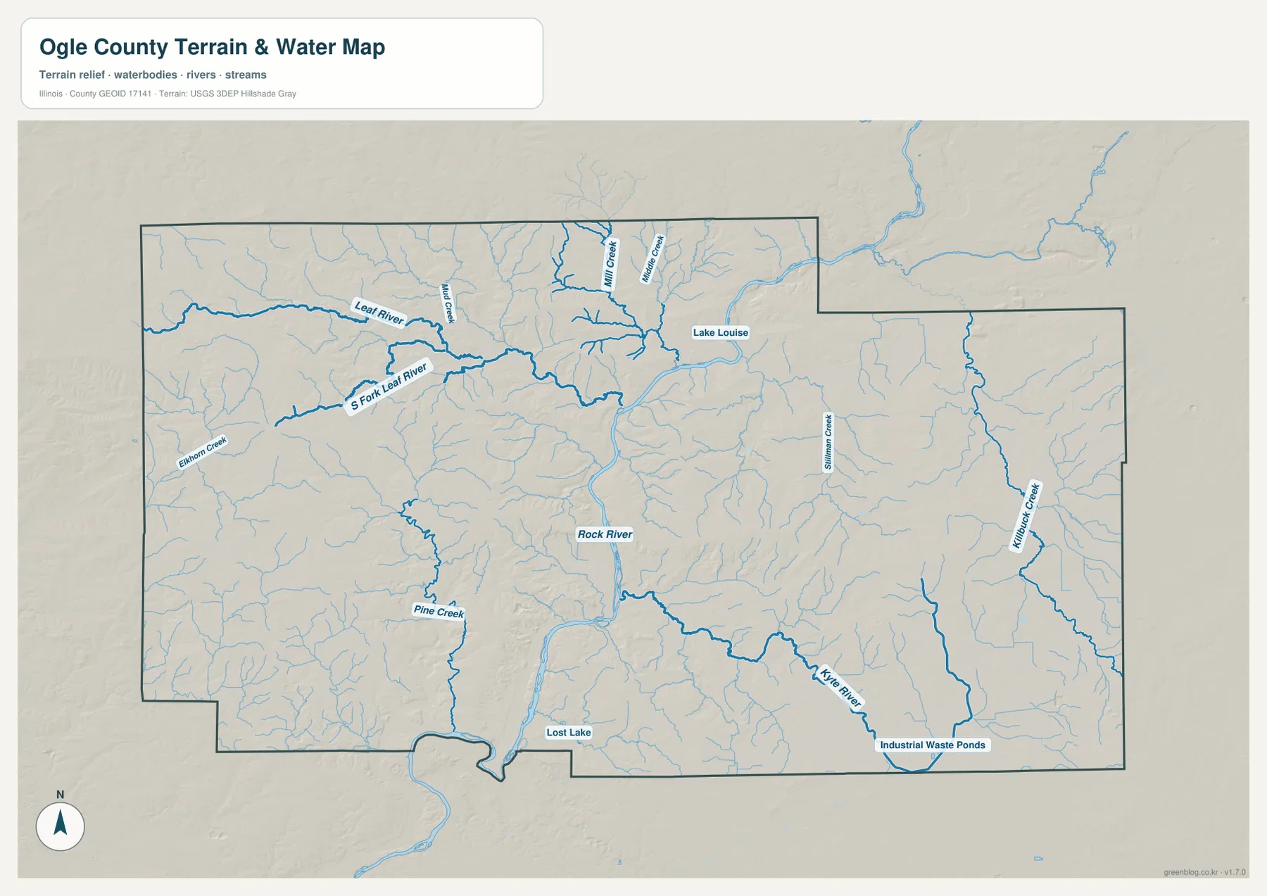
Eastern Ogle County has its own drainage pattern. Stillman Creek and Kilbuck Creek run through long north-south valleys, while Kyte River crosses the southeast. Lost Lake is labeled near the southern edge. These water features line up with lower corridors on the elevation map, but this product is a general geographic reference rather than a flood-risk map, legal water-boundary document, navigation chart, or drainage-engineering map.
From 194 m Rock River lowlands to 311 m western uplands
The elevation map reports an actual range of about 194 to 311 meters and a mean near 248 meters. The highest dark-brown terrain covers much of the west and northwest, where closely spaced tributary valleys carve a rugged surface around the Forreston, Polo, and western county areas. These uplands are not one flat high plateau; repeated ridges and creek cuts create strong local relief.
The Rock River corridor is the clearest low feature. Green terrain runs from the Byron area through Oregon and continues south, with narrow tributary valleys branching into the surrounding hills. Eastern Ogle County is generally lower and smoother than the western uplands, although east-central ridges and higher ground near the southeastern edge interrupt that broad pattern.
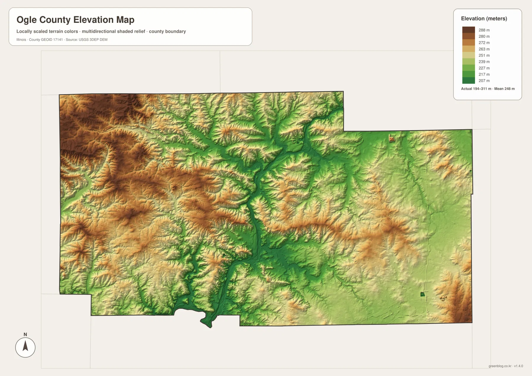
The elevation surface is generalized for county-scale comparison and should not be treated as survey-grade height, parcel elevation, or engineering data. For ordinary map reading, however, it explains the water network well. Rock River, Leaf River, Pine Creek, and the eastern creeks follow lower green corridors, while the broad tan and brown areas between them represent higher rolling ground.
Use Oregon to connect Rochelle, Byron, water, and relief across the maps
Use the county map when roads, the full boundary, and smaller settlements matter most. The ranked city map is better for comparing Rochelle, Oregon, Byron, Davis Junction, Mount Morris, and Polo without extra road detail. The terrain and water map is the clearest source for Rock River, Leaf River, Lake Louise, and the named creeks, while the elevation map explains the strong contrast between the western uplands and the central river valley.
Oregon is a useful place to follow across all four views. The road map shows Routes 2 and 64 meeting near the Rock River, the city map places Oregon second among the highlighted communities, the water map shows the river passing directly through the central area, and the elevation view marks the same corridor as a deep green lowland. Rochelle provides the southeastern highway contrast, while Byron offers another Rock River example farther north.
Frequently Asked Questions
Why does the Oregon area look so low on the elevation map?
Oregon sits in the Rock River valley, which cuts a long low corridor through the center of Ogle County. The elevation map shows this route in green from the Byron area through Oregon and southward, while the western and northwestern uplands rise much higher in tan and brown. The water and elevation maps line up closely along this valley.
Which map is best for comparing Rochelle, Oregon, and Byron?
The ranked city map is the quickest comparison. Rochelle is in the southeast, Oregon near the center, and Byron to the north. Davis Junction lies east of Byron, Mount Morris west of Oregon, and Polo in the southwest. Switch to the county map when you also want I‑39, I‑88, Routes 2, 64, 72, and the smaller communities between them.
What files are included in the downloadable ZIP?
The ZIP contains four high-resolution JPG files: the county and road map, ranked city map, terrain and water map, and elevation map. Each image is 3638 × 2572 pixels. Smaller WebP versions are used in the article for faster viewing, while the JPG files are better for close inspection and print. The water and elevation maps are general geographic references rather than flood, legal-boundary, survey, or engineering products.
Map File Information
Download the Ogle County county map, ranked city map, terrain and water map, and elevation map together as high-resolution JPG files.
- Included Files: Use only the versions confirmed in the article and supplied images
- File Type: Use the confirmed download contents
- Intended Use: Printing, education, presentations, and map-based projects
Related Maps
Sources and references
- U.S. Census Bureau TIGER/Line Shapefiles – county boundaries, roads, and place reference
- USGS National Hydrography – Rock River, Leaf River, streams, lakes, and other hydrography reference
- USGS 3D Elevation Program – elevation and terrain reference
- Illinois DNR – Lowden State Park – official information about the Rock River valley just north of Oregon
- Ogle County Yearbook – official county history and administrative reference
Green Map creates custom-edited map images using open geographic data sources such as geoBoundaries, Natural Earth, OpenStreetMap, and government open data.
These maps are edited visual materials, not raw data files, and are provided for education, documents, presentations, and graphic reference.