Coles County in east-central Illinois is easiest to learn by placing Charleston and Mattoon side by side first. Route 16 connects the two largest mapped urban areas across the south-central part of the county. Oakland reaches into the northeast, Ashmore sits east of Charleston, Humboldt is well northwest of the central pair, and Lerna lies to the south. Those outer places make the county’s shape easier to remember before the many small streams are added.
The county becomes much more varied when water and relief are brought into the picture. Embarras River and Little Embarras River cut the eastern side, Kaskaskia River touches the northwest, and Little Wabash River appears at the southwest edge. Lake Charleston and Kickapoo Creek sit below the main Charleston-Mattoon corridor, where the elevation map shows steeply dissected ridges beside low stream valleys. The high-resolution JPG originals used on this page are bundled in one ZIP download for printing, enlargement, classroom work, or presentation graphics.
Coles County’s official website lists 1830 as the year of foundation, and the Illinois State Archives records Charleston as the county seat from 1831 to the present. The county courthouse remains in Charleston. That administrative role helps distinguish Charleston from nearby Mattoon, even though the two cities are almost equally prominent on the supplied city map. Together they form the most useful central reference for the county’s roads, streams, and changing terrain.
Table of Contents
Route 16 ties Charleston and Mattoon together
The detailed overview puts Mattoon on the west and Charleston on the east, with Route 16 running directly between them. East of Charleston, the same corridor continues toward Ashmore. Mattoon is crossed by U.S. 45, and I-57 runs close to the city’s western side. Those lines make the Charleston-Mattoon area the easiest part of the map to orient before moving toward the smaller towns.
South of Mattoon, the map labels U.S. 45 and 121. Route 130 runs south from the Charleston side, while 133 reaches the Oakland area in the northeast and 49 follows the far eastern side. Humboldt is separated from the central cities in the northwest, and Lerna provides a useful southern reference. The road pattern gives the county several clear directions without hiding the extensive network of blue tributaries between them.
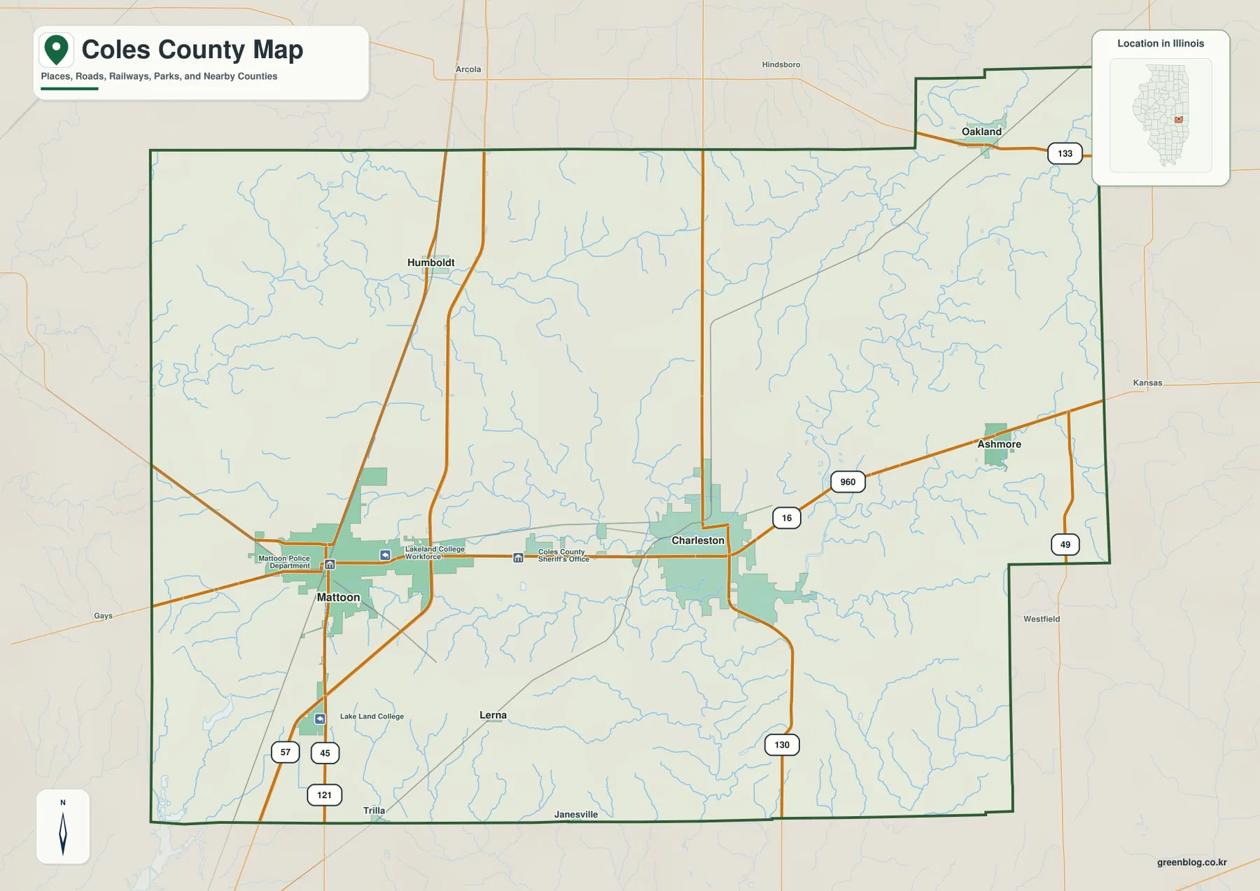
Several local labels make the central corridor more concrete, including the Coles County Sheriff’s Office, Mattoon Police Department, and Lake Land College. North of the two cities, small drainage lines spread across broad open ground. East and south of Charleston, the creek network becomes more deeply cut. Reading roads and streams together shows that the county’s transportation pattern is relatively direct even where the underlying land is divided by many winding valleys.
Charleston is the county seat
The Illinois State Archives dates the creation of Coles County to December 25, 1830 and lists Charleston as the county seat from 1831 onward. The current courthouse is also located in Charleston at 651 Jackson Avenue. That distinction matters because Mattoon is nearly as large on the city graphic; the two are neighboring population centers, but Charleston holds the county-seat role.
Charleston and Mattoon nearly share the top of the city index
The simplified city graphic ranks Charleston first and Mattoon second, with markers that are much larger than the other four places. Oakland is third, Ashmore fourth, Humboldt fifth, and Lerna sixth. The printed CITY INDEX gives 17,062 for Charleston, 16,586 for Mattoon, 862 for Oakland, 721 for Ashmore, 329 for Humboldt, and 226 for Lerna.
No census year or statistical reference date appears beside those numbers, so they are not presented here as current population counts. They are treated only as values printed on the supplied image. The location pattern itself is clear: Charleston and Mattoon form the south-central pair, Oakland fills the northeastern projection, Ashmore lies east, Humboldt northwest, and Lerna south.
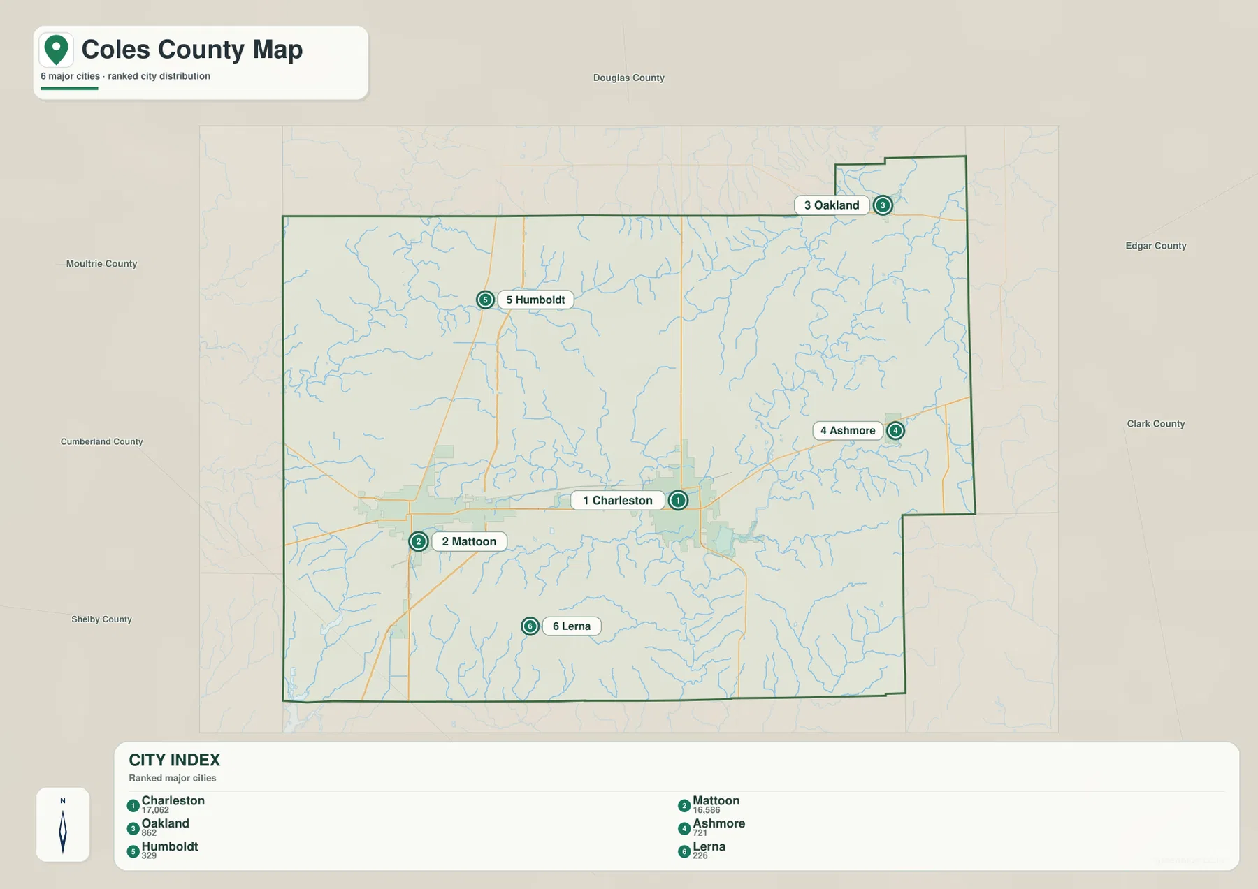
The stripped-down layout makes the county’s shape memorable. Oakland is close to the narrow northeastern extension, while Ashmore sits along the road east of Charleston. Humboldt is much farther north than Mattoon, and Lerna is well south of the central cities. Those positions give the reader a simple framework for returning to the more detailed road, water, and elevation sheets.
Use dated data for current population
A current population table should come from a source with a stated reference year, such as the U.S. Census Bureau or an official Coles County directory. The CITY INDEX on the supplied image does not identify its date. On this page, the figures are used only to describe the ranking and scale shown by the map itself.
Three river basins meet around the Embarras country
The terrain-and-water map gives the eastern county to the Embarras system. Little Embarras River descends from the Lake Oakland side, while Embarras River bends through the east-central area and continues south. Greasy Creek approaches from the northeast, and Polecat Creek with Rattlesnake Creek drains the country southeast of Charleston. These channels occupy visibly lower corridors within the shaded relief.
South of Charleston, Lake Charleston sits near Kickapoo Creek, with Riley Creek extending westward through the central-southern county. The northwest belongs to a different drainage direction, where Kaskaskia River reaches the county edge. At the southwest corner, Lake Paradise and Little Wabash River mark another basin. The map therefore shows Coles County divided among more than one river system rather than draining toward a single major channel.
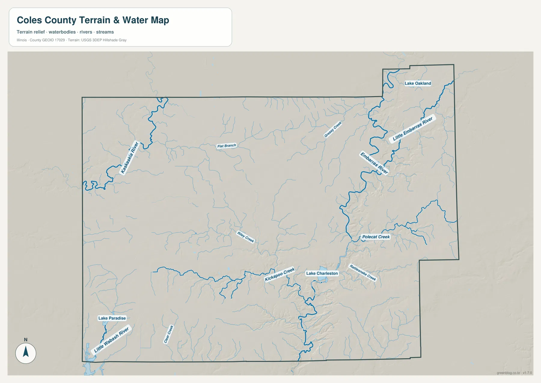
Fox Ridge State Park provides a strong local example of the terrain south of Charleston. The Illinois Department of Natural Resources describes the park as a 2,064-acre area along the wooded bluffs of Embarras River, with steep ridges, broad valleys, and rugged trails that contrast with the flatter prairie country nearby. The Embarras River Land and Water Reserve within the same area protects river, floodplain forest, and upland forest. That official description fits the tight ridge-and-valley pattern visible on the supplied terrain map.
Water location is not live flood information
The water sheet is designed to show where rivers, creeks, and lakes sit relative to the county terrain. It does not report current Embarras River stage, flood-hazard boundaries, depth, canoe conditions, or access rights. Current USGS, Illinois DNR, and local information should be used when the question depends on present water conditions or safety.
Southern ridges rise above the Embarras valleys
The elevation map reveals a strong belt of higher ground across the southern part of Coles County. Orange and brown ridges extend from the southwest toward the southeast, but green tributary valleys cut through them repeatedly. Around Charleston’s southern side and the Embarras corridor, low green channels sit immediately beside much higher ground, producing the most rugged-looking part of the county.
The map reports an actual countywide elevation range of about 162 to 239 meters and a mean near 207 meters. The legend uses color bands beginning around 182 meters and reaching into the low 230s, while the separate “Actual” line records the broader dataset extremes. Those values describe Coles County as a whole; they are not exact elevations for Charleston, Mattoon, Lerna, or any particular property.
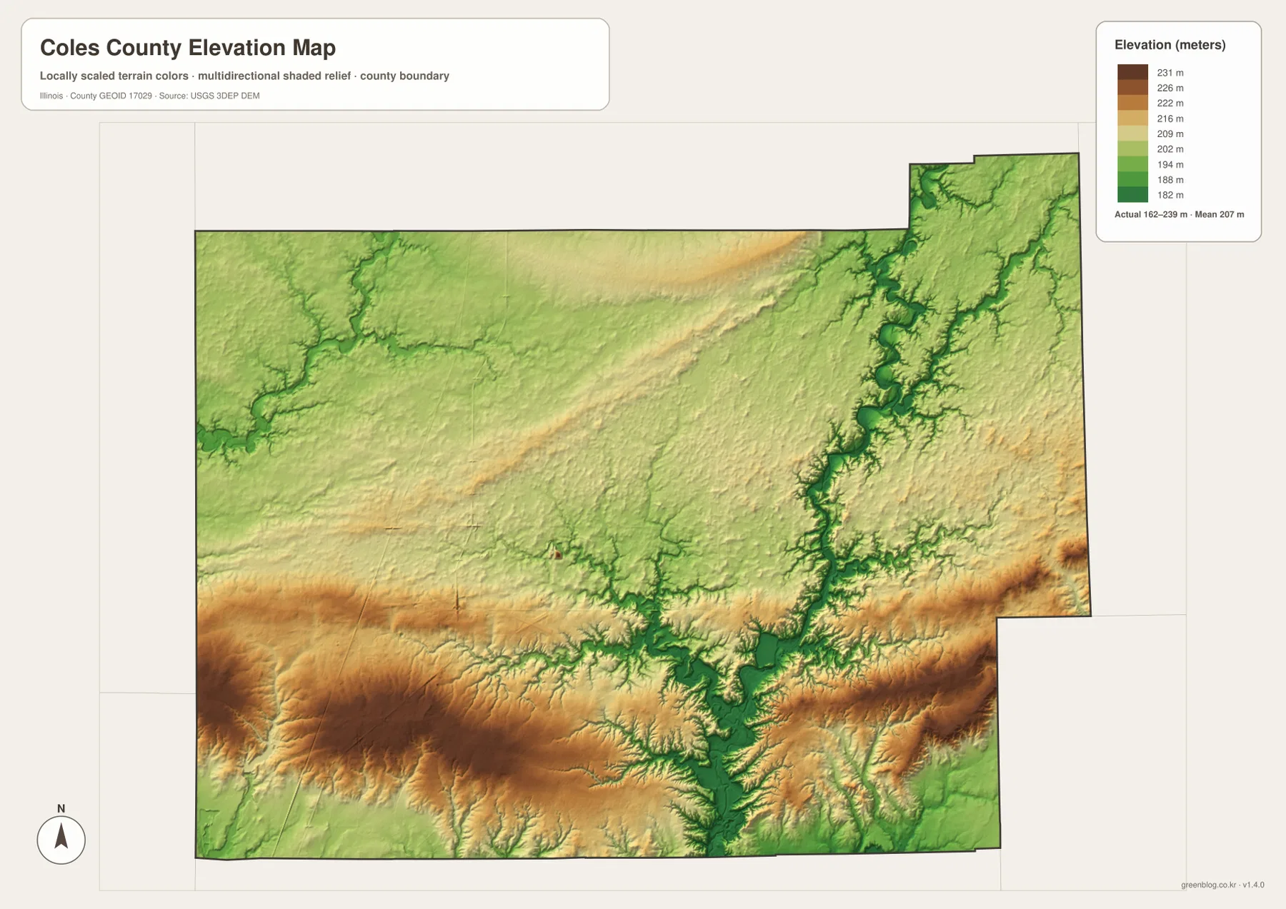
Matching the elevation and water sheets makes the green corridors easier to interpret. Embarras River, Kickapoo Creek, and Kaskaskia River occupy lower channels, while the terrain south of Charleston rises sharply into higher ridges. IDNR’s description of Fox Ridge as wooded bluffs and ravines along the Embarras provides a real local counterpart to the relief shown here. North-central Coles County is comparatively smoother, making the southern belt stand out even more clearly.
Countywide elevation is not a site survey
A road grade, building site, drainage design, bridge, or parcel needs point-specific elevation data or a professional survey. The 162–239 meter range is useful for comparing the southern uplands with the river valleys, but neither endpoint should be assigned to a named town or street address.
Keep Charleston and Mattoon fixed while changing map layers
A practical way to use the set is to hold the Charleston-Mattoon pair in mind as each layer changes. Begin on Route 16 and locate Oakland, Ashmore, Humboldt, and Lerna around the two central cities. The city graphic then simplifies those relationships. On the water map, Charleston becomes the reference for Embarras River, Lake Charleston, and Kickapoo Creek, while the northwest and southwest corners reveal the Kaskaskia and Little Wabash drainage directions.
The elevation image completes the geographic picture. The country south of Charleston is much more broken and elevated than the road map initially suggests, with low green valleys cutting through orange and brown ridges. Farther north, broader areas of gentler relief surround the outer towns. Looking at roads, settlement spacing, water, and relief together gives a more accurate sense of Coles County than any one sheet can provide.
Use current transportation data for driving conditions, dated Census or county material for population, water agencies for river stage or flood questions, and point-level elevation data for site work. Within those limits, the files are well suited to printed references, lessons, presentations, and advance orientation across Coles County.
Frequently Asked Questions
What is the county seat of Coles County, Illinois?
Charleston is the county seat. The Illinois State Archives records Charleston in that role from 1831 to the present, and the current Coles County Courthouse is in Charleston. Mattoon is nearly as prominent on the city map, but it does not hold the county-seat role.
Why does the terrain south of Charleston look more rugged?
The Embarras River and its tributaries cut low valleys next to higher ridges in that part of the county. Illinois DNR describes nearby Fox Ridge State Park as steep wooded ridges and broad valleys along the Embarras River, which matches the strong relief visible on the elevation map south of Charleston.
Does 162 to 239 meters give Charleston’s elevation?
No. The elevation image identifies 162–239 m as the actual range across the Coles County dataset and gives a mean of about 207 m. Exact elevation for Charleston or any specific road, property, or structure requires point-specific elevation or survey data.
Sources and Reference Material
The article uses the supplied Coles County maps together with the official references below. For current road conditions, Embarras River levels, park rules, legal boundaries, or exact point elevations, consult the responsible agency’s latest material rather than relying on a static county reference map.
- Coles County Official Website – county overview, Charleston and Mattoon context, and courthouse information
- Illinois State Archives – Coles County – county establishment, name origin, and Charleston county-seat history
- Illinois DNR – Fox Ridge State Park – Embarras River bluffs, ridges, and valleys south of Charleston
- USGS National Hydrography – river, stream, and lake reference data
- USGS 3D Elevation Program – elevation and terrain data
Map File Information
The ZIP file contains the high-resolution JPG originals for the Coles County overview, city map, terrain-and-water map, and elevation map. Each landscape image measures 3,638 × 2,572 pixels, keeping Route 16 town labels, smaller creek names, and the southern relief colors clearer when enlarged or printed.
- Included Files: 4 high-resolution JPG maps
- Printable Size: 3,638 × 2,572 pixels each
Related Maps
Green Map creates custom-edited map images using open geographic data sources such as geoBoundaries, Natural Earth, OpenStreetMap, and government open data.
These maps are edited visual materials, not raw data files, and are provided for education, documents, presentations, and graphic reference.