Download the high-resolution JPG originals for this Capitol Planning Region Map in the ZIP below. The page covers Hartford, New Britain, surrounding urban and suburban communities, the major highway network, and waterways ranging from the Connecticut and Farmington rivers to the Willimantic and Fenton rivers farther east. The WebP maps are convenient for quick browsing, while the full-size JPG files are better for printing, detailed inspection, and offline reference.
Capitol Planning Region is not simply another traditional Connecticut county name. Connecticut uses nine planning regions as geographic frameworks for municipalities to coordinate regional interests, and the U.S. Census Bureau lists Capitol Planning Region in its Connecticut county-equivalent geography. That makes the name appear in county datasets even though the region is better understood as a planning area centered on Hartford and extending across a large mix of urban, suburban, and rural municipalities.
Table of Contents
Hartford, New Britain, and the region’s main highway web
The boundary map is densest around Hartford. West Hartford sits immediately to the west, East Hartford lies across the river, and Wethersfield and Newington extend the built-up area to the south. New Britain forms another major center farther southwest, with Kensington nearby. North of Hartford, Windsor Locks and Broad Brook appear along the central-northern corridor, while Manchester anchors a major eastern suburban area.
The road network reinforces that urban concentration. I-84 and I-91 meet in the Hartford area, I-291 provides a northeastern connection, and I-384 extends toward Manchester and the eastern side of the metro area. Routes 2, 9, and 72 plus I-691 help connect the southern and southwestern parts of the region. These roads are far more tightly packed around Hartford and New Britain than in the northeastern part of the planning region, where town labels are farther apart and the map shows more streams and open green areas between communities.
The broader map also includes places such as Storrs, Crystal Lake, and Stafford Springs toward the east and northeast, showing that Capitol Planning Region extends well beyond the Hartford urban core. Nearby outside labels such as Bristol, Middletown, Portland, and Norwich help establish the region’s position in central Connecticut. Taken together, the settlement and road patterns show one planning region containing a dense capital-city core and a much more dispersed inland fringe.
A ranked city map with Hartford first and New Britain second
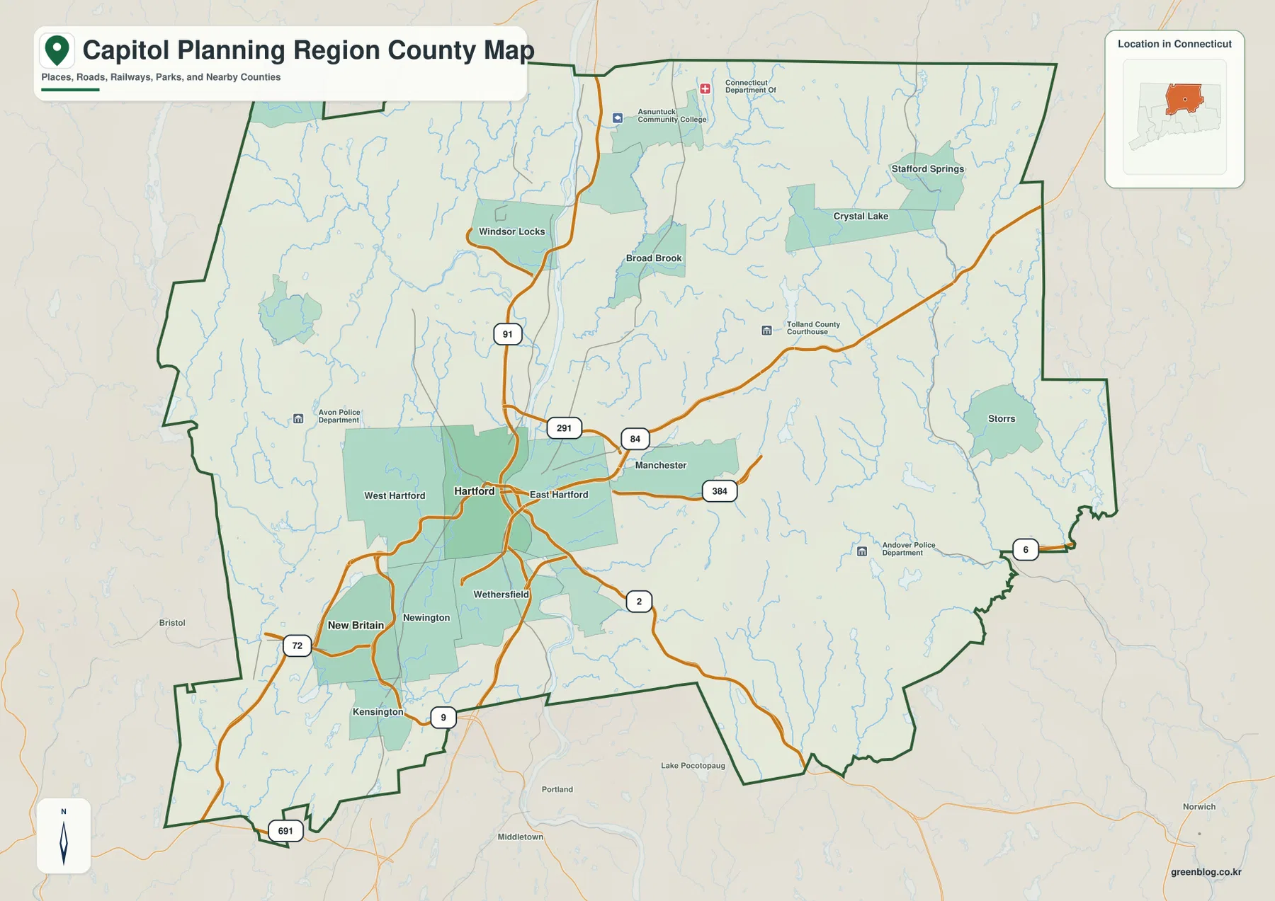
The city layer is a ranked distribution map rather than a connector-distance map. Its CITY INDEX places Hartford first and New Britain second. No straight-line mileage or driving distance is drawn between them, so the map is most useful for seeing where the two largest city centers sit inside the much broader planning-region boundary.
Hartford occupies the west-central portion of the region, while New Britain lies to the southwest. Their positions reinforce the concentration visible on the road map: the principal ranked cities sit in the western half, where the transportation network is also densest. The eastern and northeastern sections have a large geographic footprint but no second tier of ranked cities on this layer, leaving streams, local roads, and smaller town centers as the main map features.
Labels outside the boundary identify neighboring planning regions, including Northwest Hills, Lower Connecticut River Valley, Naugatuck Valley, South Central Connecticut, Southeastern Connecticut, and Northeastern Connecticut. Those labels are useful because Connecticut’s planning-region system creates a modern regional geography that does not follow the old county pattern exactly. The city map therefore works as both a settlement overview and a quick reference for how Capitol Planning Region fits among the state’s other planning regions.
Connecticut River, Farmington River, and a web of eastern tributaries
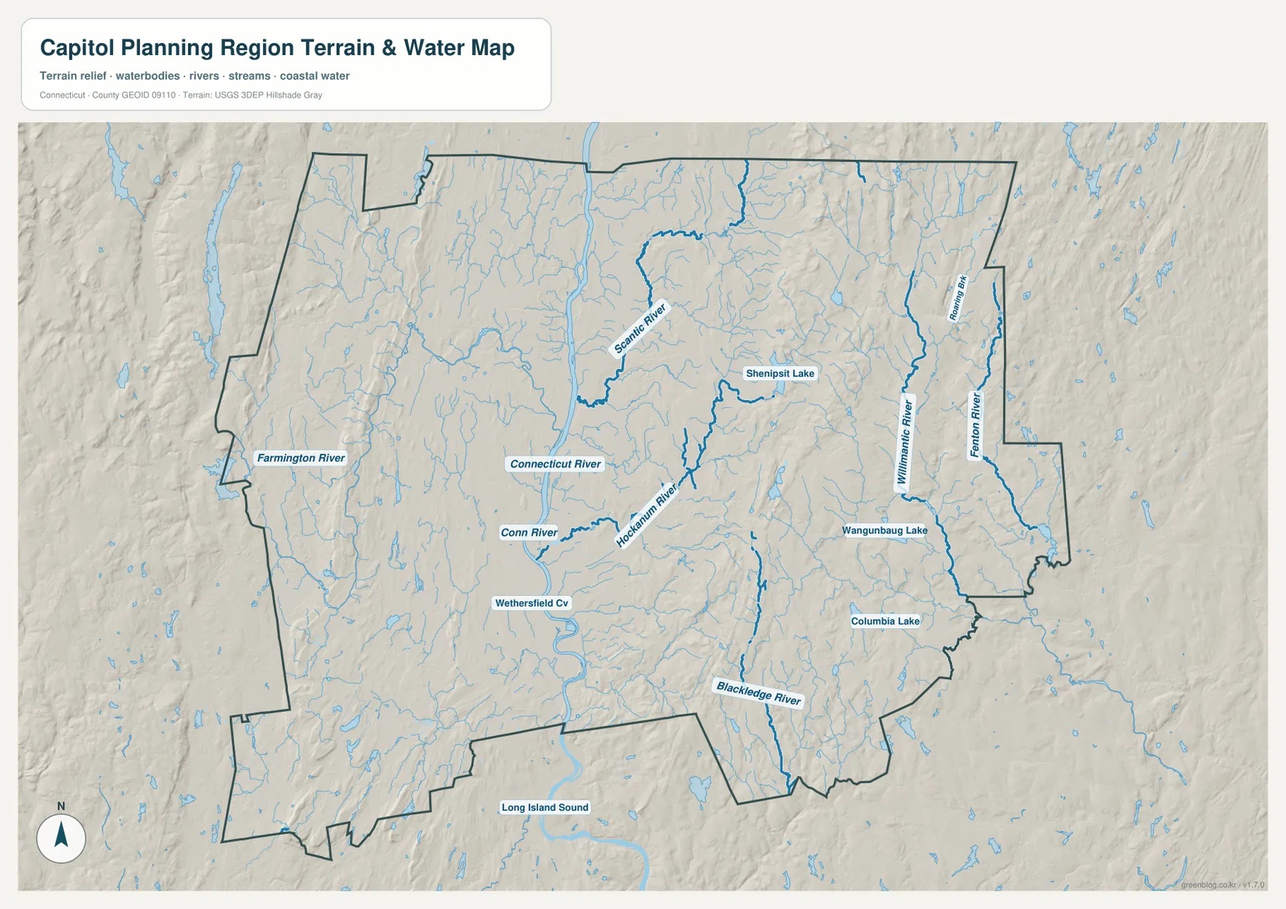
The Connecticut River is the strongest water reference on the terrain map, running through the central-western part of the region and directly through the Hartford metropolitan area. The Farmington River approaches from the west and provides another major reference for the western portion of the planning region. Wethersfield Cove is labeled just south of Hartford, adding a smaller but useful water landmark near the main river corridor.
North and northeast of Hartford, Scantic River follows a more winding route through the interior. Hockanum River is important on the eastern side of the Hartford urban area, linking the Manchester side of the region with the Connecticut River corridor. These rivers show why the metropolitan portion of the map is not only a highway landscape; significant river valleys pass directly through and around the largest communities.
The eastern half has a different water pattern. Willimantic River and Fenton River are prominent in the northeast and east, Blackledge River runs through the southeastern part of the region, and Roaring Brook is labeled near the northeastern side. Numerous smaller unnamed tributaries fill the terrain between them. This dense network makes the large eastern area look much more detailed on the water map than on the ranked city map.
Several lakes provide useful landmarks away from the Hartford core. Shenipsit Lake is near the northeastern-central portion of the region, while Wangumbaug Lake and Columbia Lake appear farther southeast. These water bodies help distinguish the inland eastern landscape from the Connecticut River metro corridor. The layer is intended for general geographic reference and should not be used as a flood-hazard map, water-rights document, legal channel boundary, or navigation chart.
Why this boundary is a planning region rather than an old county
Connecticut’s state government describes nine planning regions that give municipalities a geographic framework for coordinating regional interests and state programs. Each region has a regional council of governments created by its member municipalities. The Capitol Region Council of Governments serves the Hartford-centered region and describes its membership as 38 municipalities spanning urban, suburban, and rural communities.
The Census Bureau also publishes Capitol Planning Region in its Connecticut county geography, with GEOID 09110. In other words, users may encounter this boundary in county-level Census files even though the public-facing regional name remains Capitol Planning Region. That distinction matters for a map-download page because it explains why the file behaves like a county geography in federal data while the region itself is organized around regional planning and municipal cooperation.
Comparing the Hartford core with the northeastern interior
A useful way to read the maps is to compare Hartford with the Storrs–Stafford side of the region. Around Hartford, West Hartford, East Hartford, Wethersfield, Newington, and Manchester create a continuous cluster of place names and highways. The Connecticut River, Hockanum River, and Wethersfield Cove also sit close to that dense transportation network, so urban geography and water geography overlap strongly.
Farther northeast, the pattern changes. Crystal Lake, Stafford Springs, and Storrs are separated by larger areas of streams and open terrain, while Willimantic River, Fenton River, Scantic River, and Roaring Brook become more prominent map references. The contrast shows why Capitol Planning Region should not be reduced to downtown Hartford: the boundary includes a major urban core as well as a much more dispersed interior landscape.
Choosing the right map for the question you have
Use the boundary and road map first when you need Hartford, New Britain, West Hartford, East Hartford, Manchester, Storrs, major highways, and the region outline in one view. The ranked city map is the quickest way to see that Hartford and New Britain are the two highlighted city centers, but it does not provide mileage. Use the water and terrain map for the Connecticut, Farmington, Scantic, Hockanum, Willimantic, Fenton, and Blackledge rivers as well as the named lakes.
For example, compare the road and water maps to understand how I-84, I-91, Hartford, and the Connecticut River occupy the same metro corridor. Use the city map to compare Hartford and New Britain’s positions without inventing a distance that is not shown. For Stafford Springs or Storrs, the boundary map identifies the communities and the water layer adds the surrounding inland drainage network. Because this package contains three maps and no elevation map, the article stays focused on the boundary, city distribution, roads, and water features actually provided.
Frequently Asked Questions
Is Capitol Planning Region the same thing as a traditional Connecticut county?
Not exactly. Connecticut uses nine planning regions for regional coordination, and the Census Bureau also treats those planning regions as county-equivalent geography in federal county datasets. The correct regional name for this boundary is Capitol Planning Region.
Does the city map show the distance between Hartford and New Britain?
No. The ranked city layer places Hartford first and New Britain second but does not include connector lines, straight-line mileage, or driving distance. Use it to compare location and rank rather than travel distance.
Which map is best for the Connecticut and Farmington rivers?
The water and terrain map is the best choice. It shows the Connecticut and Farmington rivers along with Scantic, Hockanum, Willimantic, Fenton, and Blackledge rivers, plus named lakes including Shenipsit Lake, Wangumbaug Lake, and Columbia Lake.
Map File Information
The ZIP contains the original high-resolution JPG versions of the boundary/road, ranked city, and water/terrain maps shown on this page. Use the larger files for printing, detailed viewing, or offline reference.
- Included Files: Use only the versions confirmed in the article and supplied images
- File Type: Use the confirmed download contents
- Intended Use: Printing, education, presentations, and map-based projects
Related Maps
Sources and references
- State of Connecticut – Regional Councils of Governments – Connecticut’s nine planning regions and regional council structure
- Capitol Region Council of Governments – Unified Planning Work Program – Hartford-centered region and 38 member municipalities
- U.S. Census Bureau TIGER/Line Shapefiles – planning-region boundary, roads, and place reference
- USGS National Hydrography – rivers, streams, and lakes
Green Map creates custom-edited map images using open geographic data sources such as geoBoundaries, Natural Earth, OpenStreetMap, and government open data.
These maps are edited visual materials, not raw data files, and are provided for education, documents, presentations, and graphic reference.