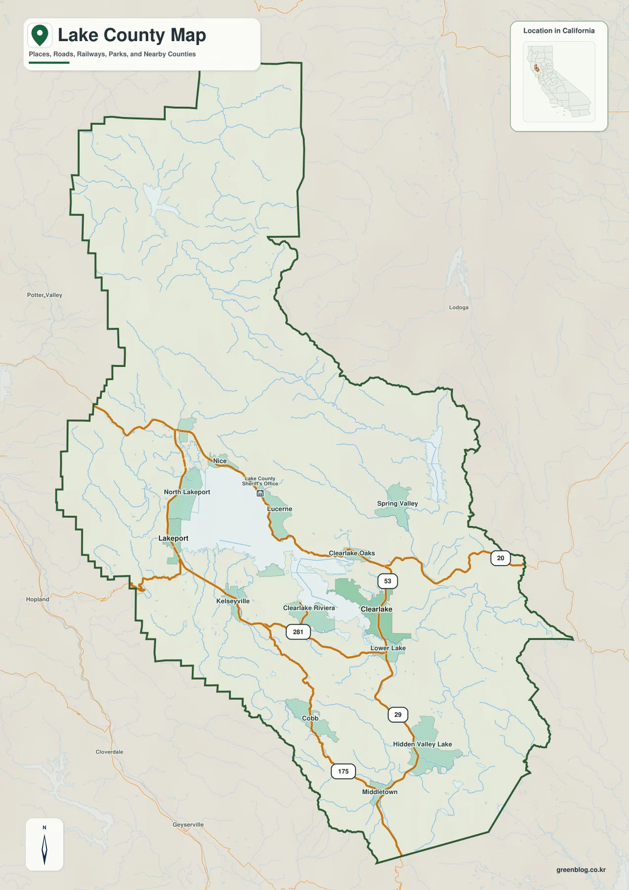
Lake County in Northern California is organized around water and mountain terrain more clearly than many neighboring counties. Clear Lake fills the center of the county, with Lakeport on the western shore and Clearlake on the southeastern side. Nice, Lucerne, Clearlake Oaks, Kelseyville, Lower Lake, and several other communities form a loose ring around the lake. Farther north, the landscape changes into rugged mountain country around Lake Pillsbury and the Eel River, while the southern county breaks into smaller valleys around Middletown and Hidden Valley Lake.
Download the original high-resolution A3 JPG files from this Lake County California Map page in one ZIP. The package contains a county reference map, a ranked city-distribution map, and a terrain-and-water map. There is no separate elevation map in the supplied bundle, so descriptions of lower shore areas and surrounding mountains stay with the visible relief shading and verified Lake County geographic information.
Table of Contents
Lakeport is the county seat on the western shore of Clear Lake
Lakeport is the county seat of Lake County. The county’s current hazard-mitigation plan identifies Lakeport as the seat of government, and the reference map places it on the western shore of Clear Lake. North Lakeport lies immediately to the north, while State Route 29 passes along the western side and continues south toward Kelseyville.
Using Lakeport as a starting point makes the lake-shore geography easy to organize. Nice appears on the northern shore, Lucerne and Clearlake Oaks line the east, and Kelseyville and the Clearlake Riviera area lie farther south. Because Clear Lake is so large, communities that look close across the water can require much longer road trips around the shoreline.
Lake County’s 2025 Multi-Jurisdictional Hazard Mitigation Plan distinguishes Lakeport and Clearlake as the county’s two incorporated cities and identifies Lakeport as the county seat. Communities such as Nice, Lucerne, Clearlake Oaks, Kelseyville, and Lower Lake do not appear in the ranked city panel, but they are essential to understanding how settlement actually wraps around Clear Lake.
Clearlake anchors the southeastern shore around Routes 53 and 20
Clearlake is the larger of the two incorporated cities and occupies the southeastern side of Clear Lake. State Route 53 runs along the eastern side of the city and provides a direct north–south reference between the Clearlake Oaks area and Lower Lake. State Route 20 continues east from Clearlake Oaks toward Colusa County and also serves the northern and eastern shore region.
West of Clearlake, the Clearlake Riviera and Kelseyville areas occupy the southern lake side. Route 281 provides another local connection across this section. Farther south, Highway 29 leads from Lower Lake toward Hidden Valley Lake and Middletown, where the map leaves the immediate Clear Lake basin and enters a more broken landscape of smaller valleys and hills.
Route 175 is useful for the southwestern mountain side around Cobb and the approaches toward Middletown. Cobb lies in hill country south of Kelseyville, well away from the broad lake shore. This road pattern shows why Lake County should not be read only as a ring around Clear Lake: the southern county has its own communities and mountain corridors.
Clearlake is larger on the city map, but Lakeport remains the administrative center
The supplied city-distribution graphic ranks two incorporated cities. Clearlake is shown first at 16,659 and Lakeport second at 5,113. These are comparison values printed on the supplied map rather than the newest Census estimates, so current demographic work should use an official statistical source.
The two cities also occupy different sides of the lake. Lakeport sits on the western shore and Clearlake on the southeastern shore. The Lake County Sheriff’s Office policy manual identifies the City of Lakeport and the City of Clearlake as the county’s two incorporated cities, which explains why only two ranked municipal points appear in this graphic.
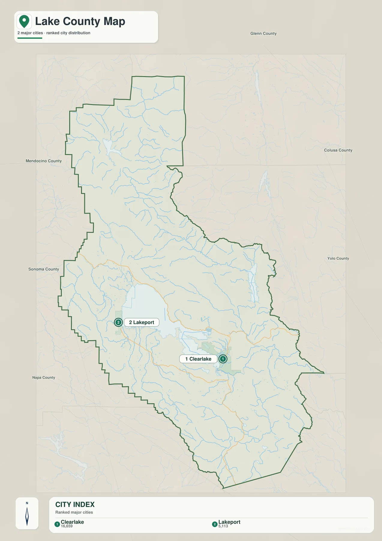
The ranked city view intentionally leaves out many important local communities. Nice, Lucerne, Clearlake Oaks, Kelseyville, Lower Lake, Middletown, and Cobb remain visible on the broader reference map. Use the city graphic for municipal comparison and return to the county map for the full settlement pattern.
Clear Lake dominates the center and pulls many communities toward its shoreline
Clear Lake is the largest feature on the terrain-and-water map. Lake County Water Resources describes it as the largest natural freshwater lake entirely within California. Its size explains much of the local geography: Lakeport, Nice, Lucerne, Clearlake Oaks, Clearlake, Kelseyville, and other communities are positioned around the lake rather than across one continuous valley floor.
Several mountain streams feed the lake. Scotts Creek descends from the western uplands toward the northwestern side, while Kelsey Creek approaches from the southwest. Cole Creek is also labeled in the southern lake basin. Lake County’s hydrologic-monitoring page lists Scotts Creek, Kelsey Creek, Middle Creek, and other tributaries as active monitoring locations, confirming their importance in the Clear Lake watershed.
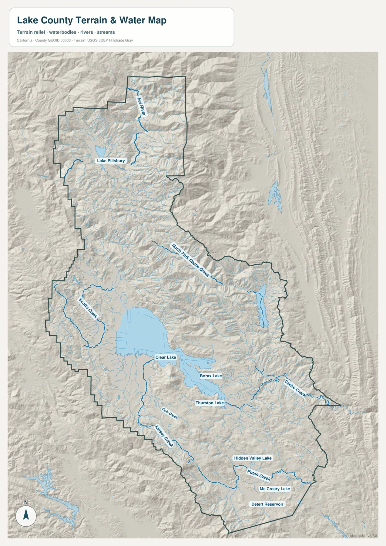
Borax Lake and Thurston Lake appear southeast of Clear Lake, while Hidden Valley Lake, McCreary Lake, and Detert Reservoir provide smaller landmarks farther south. These water bodies are tiny beside Clear Lake but useful for orienting the southern county. They also show how the landscape changes from one dominant central lake to several smaller basins and creeks.
Cache Creek is the natural outlet from Clear Lake toward the east
Clear Lake’s natural outlet is Cache Creek. California State Parks explains that the lake ultimately found an outlet through Cache Creek toward the Sacramento River system after ancient drainage changes in the basin. On the supplied terrain map, Cache Creek leaves the southeastern side of the lake and winds east through mountain terrain toward the county boundary.
Lake County’s Cache Creek Dam information emphasizes that Cache Creek is the lake’s natural drainage path and that the narrow channel can limit how quickly water leaves Clear Lake during prolonged storms. The county-scale map does not show real-time stage, flood risk, or dam operations, but it clearly shows the basic connection between the lake and its downstream outlet.
North Fork Cache Creek is labeled separately farther east and northeast. It should not be mistaken for the direct Clear Lake outlet. Lake County maintains separate hydrologic monitoring for North Fork Cache Creek, which is a useful reminder that the eastern part of the county contains more than one major drainage branch.
Lake Pillsbury and the Eel River form a separate northern watershed
The northern end of Lake County belongs to a very different water system. Lake Pillsbury is prominently labeled in the mountain interior, with the Eel River and tributaries nearby. Lake County’s 2023 Hazard Mitigation Plan describes Lake Pillsbury as a major reservoir in the Eel River drainage in the northwestern part of the county.
The county’s Lake Pillsbury page explains that the reservoir was created by Scott Dam and is tied to the upper Eel River system. On the terrain map, mountain relief is much stronger around the reservoir than around the settled Clear Lake shore. Large community labels are scarce, and rivers, ridges, and reservoir shape become better orientation tools than city streets.
This difference is important because Lake Pillsbury is not simply another arm of Clear Lake. The two water bodies belong to separate drainage settings. Clear Lake drains through Cache Creek, while Lake Pillsbury lies in the Eel River watershed. Seeing both on one map makes the county’s watershed diversity especially clear.
Putah Creek and the southern lakes mark another set of valleys below Clear Lake
South of the main lake, Putah Creek becomes a useful geographic reference. It is labeled near Hidden Valley Lake and continues toward the southeastern county boundary. McCreary Lake and Detert Reservoir appear nearby. These features sit in smaller mountain valleys rather than in the broad basin occupied by Clear Lake.
The reference map places Middletown and Hidden Valley Lake along Highway 29, with Cobb in the hills to the west. Lake County’s official district descriptions group Middletown, Hidden Valley, Cobb, and Lower Lake within the South County area. The map supports that distinction: the southern communities are separated from the main lake shore by hills, creeks, and winding roads.
This southern section also explains why a simple “lake-shore county” description is incomplete. Clear Lake is the dominant landmark, but large parts of Lake County extend into upland valleys where smaller creeks and local reservoirs matter more for orientation than the central lake itself.
Mountain terrain surrounds the lake and narrows many road corridors
There is no separate elevation map in this package, but the relief shading makes the county’s mountain setting obvious. Lake County background material describes the county as surrounded by mountainous terrain, with Clear Lake creating a major division between shore communities. Lower land is concentrated around the lake and in several valleys, while ridges rise quickly around much of the basin.
The strongest relief appears around Lake Pillsbury in the north, North Fork Cache Creek in the east, and the Cobb–Middletown side in the south and southwest. Lakeport, Kelseyville, and Clearlake occupy relatively broader lowland or gently rolling areas. Precise elevation work requires dedicated USGS elevation data; the supplied terrain image is intended for broad comparison rather than measurement.
Clear Lake State Park provides a useful real-world reference on the southeastern side of the lake near Kelseyville. California State Parks places the park on the Clear Lake shore and describes it as a major destination for boating, fishing, swimming, and wildlife viewing. Its location shows how recreation areas, communities, and the large natural lake are tightly connected in the central county.
Start with Clear Lake, then separate the Lake Pillsbury north from the Middletown south
A practical first pass is to locate Clear Lake and move around the shoreline. Find Lakeport on the west, Nice on the north, Lucerne and Clearlake Oaks on the east, and Clearlake on the southeast. Routes 20, 29, and 53 then provide a simple road framework for these communities.
Next, move north to Lake Pillsbury and the Eel River to see the separate mountain watershed. On the eastern side, distinguish North Fork Cache Creek from Cache Creek, the outlet from Clear Lake. Finally, move south to Hidden Valley Lake, Putah Creek, and Middletown. Dividing the county into central lake shore, northern mountain watershed, eastern Cache Creek country, and southern valleys makes the map much easier to read.
Choose the map according to whether you need shore communities, roads, or watershed detail
The county reference map is the best starting point for Lakeport, Clearlake, Nice, Lucerne, Kelseyville, Middletown, state highways, and the county boundary. The city-distribution graphic gives a clean comparison of the two incorporated cities. The terrain-and-water map is the strongest choice for Clear Lake, Lake Pillsbury, the Eel River, Cache Creek, North Fork Cache Creek, and the smaller southern water bodies.
For teaching or regional explanation, the reference and terrain maps work especially well together. Lakeport and Clearlake can be placed on opposite parts of Clear Lake, Lake Pillsbury can illustrate the separate Eel River mountain watershed, and Middletown–Hidden Valley Lake can show how the county changes into smaller southern valleys away from the central lake.
Each downloadable JPG measures 2572 × 3638 pixels and is suitable for A3 portrait printing, enlarging small place and creek labels, or placing a map in a report or classroom handout. Keep the original aspect ratio when resizing so roads, lakes, streams, and the county outline are not distorted. Printer margins vary, so checking one test page before a larger print run is useful.
Frequently Asked Questions
Is Clearlake or Lakeport the county seat of Lake County, California?
Lakeport is the county seat. Clearlake is larger on the supplied city-ranking map, but county government is centered in Lakeport. The two incorporated cities occupy different parts of the Clear Lake shore.
Where does water leave Clear Lake?
Cache Creek is the natural outlet from Clear Lake. It leaves the southeastern side of the lake and continues east toward the Sacramento River system. North Fork Cache Creek is a separate tributary in the eastern mountain drainage and should not be confused with the lake’s direct outlet.
Does this download include a separate elevation map?
No. This Lake County package contains the county reference map, city-distribution map, and terrain-and-water map. Relief shading shows the contrast between the Clear Lake basin and surrounding mountains, but no separate numeric elevation map is included.
Map File Information
The ZIP contains the original Lake County reference, city-distribution, and terrain-and-water maps as high-resolution JPG files.
- Included Files: County reference map, city-distribution map, terrain-and-water map
- Printable Size: 2572 × 3638 pixels each
- File Type: Three high-resolution JPG files in one ZIP archive
Related Maps
Sources and References
- 2025 Lake County Multi-Jurisdictional Hazard Mitigation Plan – Official county information on Lakeport as county seat, Clearlake and Lakeport as incorporated cities, and regional geography.
- Lake County – Clear Lake – Official county information on Clear Lake, its size, wildlife, and importance to the basin.
- Lake County – Hydrologic Information – Official monitoring information for Clear Lake, Cache Creek, North Fork Cache Creek, Scotts Creek, Kelsey Creek, and other waterways.
- Lake County – Lake Pillsbury – Official information on Lake Pillsbury and its relationship to the upper Eel River watershed.
- California State Parks – Clear Lake State Park – Official information on the Clear Lake shore, Cache Creek outlet history, and the park near Kelseyville.
Green Map creates custom-edited map images using open geographic data sources such as geoBoundaries, Natural Earth, OpenStreetMap, and government open data.
These maps are edited visual materials, not raw data files, and are provided for education, documents, presentations, and graphic reference.