Humboldt County occupies a large section of California’s North Coast, combining the urban communities around Humboldt Bay with extensive redwood forests, rugged coastal mountains, and several major river valleys. Eureka, the county seat, and Arcata form the most prominent coastal city pair. Fortuna and Rio Dell lie farther south in the Eel River country, while Willow Creek and Hoopa are far inland where winding highways follow deep mountain drainages. Much of the county is easier to understand through rivers and roads than through city names alone.
Download the original high-resolution A3 JPG files from this Humboldt County California Map page in one ZIP near the end of the article. The package contains a county reference map, ranked city-distribution map, and terrain-and-water map. There is no separate elevation map in the supplied package, so terrain descriptions stay with the visible hill shading, river valleys, and verified Humboldt County geography.
Table of Contents
Eureka and Arcata concentrate the largest urban area around Humboldt Bay
Humboldt County’s official overview identifies Eureka as the county seat. On the reference map, Eureka is the largest developed area along the western coast, with Arcata immediately to the north. The two cities sit around the Humboldt Bay–Arcata Bay area, where roads, schools, medical facilities, and settlement labels are much denser than they are across the inland mountains.
McKinleyville extends the coastal settlement pattern north of Arcata along U.S. 101. South of Eureka, Pine Hills and the College of the Redwoods provide additional map references before the highway continues toward Fortuna. Using U.S. 101 as the first guide makes Humboldt County’s western population pattern easy to follow because many of the best-known communities sit close to this north–south route.
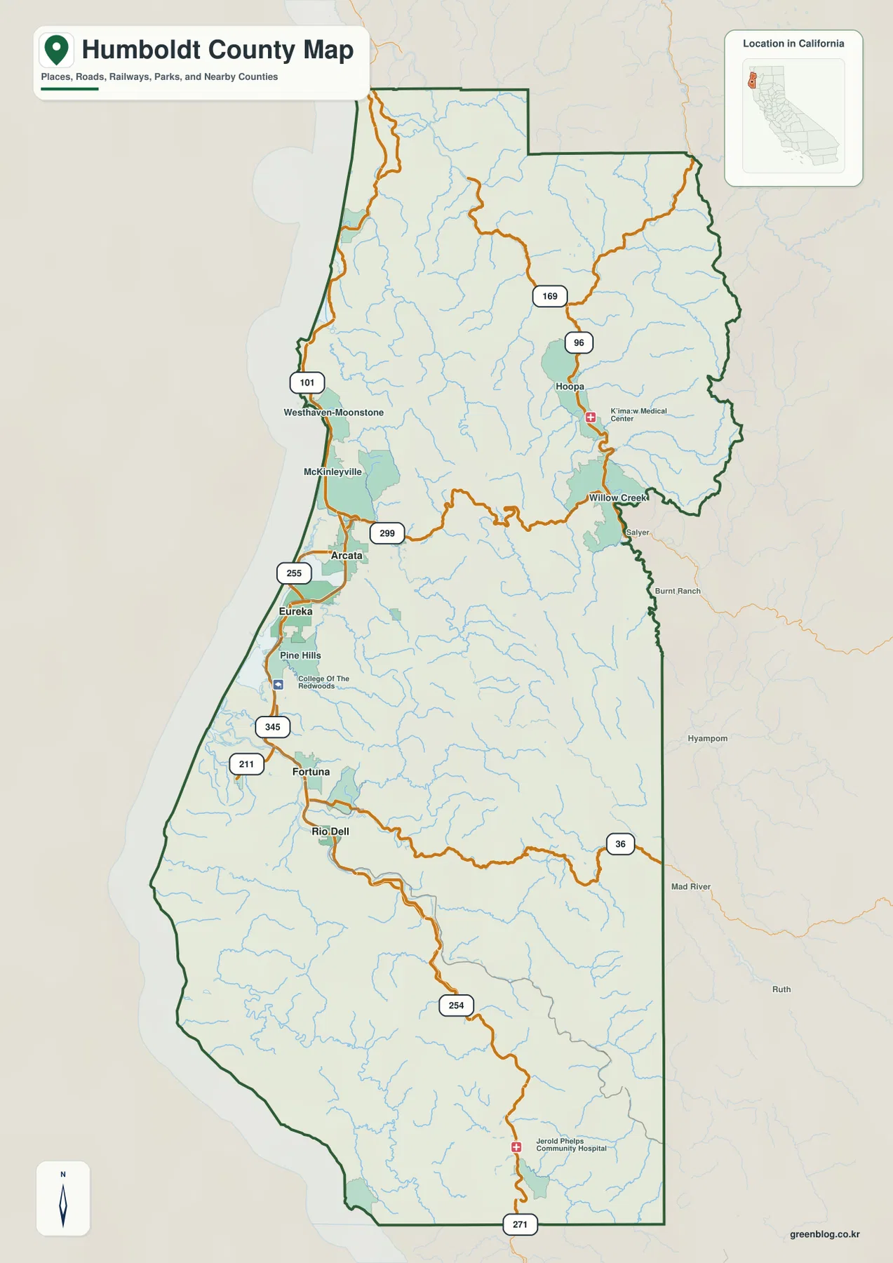
The county’s current overview says population is concentrated primarily around Humboldt Bay communities including Eureka, Arcata, and McKinleyville. The supplied map reflects that pattern clearly. Large areas to the north, east, and south contain few major developed zones even though the county boundary encloses a vast network of roads, streams, forests, and mountain terrain.
Fortuna and Rio Dell follow the Eel River corridor into southern redwood country
Following U.S. 101 south from Eureka brings Fortuna into view, with Rio Dell farther south where the valley narrows. Fortuna is the largest southern city shown on the reference map, while Rio Dell sits closer to the Eel River mountain corridor. Together they provide a second major settlement reference outside the Humboldt Bay area.
Route 211 leads west from the Fortuna side toward Ferndale, and Route 254 appears farther south along the Eel River corridor. That road is associated with the Avenue of the Giants. California State Parks places Humboldt Redwoods State Park about 45 miles south of Eureka and highlights the 32-mile Avenue of the Giants through its old-growth redwood forest.
The southern map becomes progressively more river-centered. U.S. 101 and Route 254 stay within the broader Eel River setting while tributaries and shaded ridges become more prominent. Once Fortuna and Rio Dell are located, the relationship between road corridors, redwood forest, and the main river valley is much easier to see.
Route 299 leaves Arcata for Willow Creek and the interior mountain valleys
State Route 299 provides the clearest east–west route from the coast into the interior. It leaves the Arcata side and crosses a long stretch of rugged terrain before reaching Willow Creek. Settlement labels become less frequent as the road moves inland, while streams and ridges become much more important on the map.
Willow Creek serves as a strong eastern reference point. From there, Route 96 leads north toward Hoopa and the Klamath–Trinity river country. Hoopa is shown as a significant inland community, and the reference map labels the K’ima:w Medical Center nearby. These features make the Willow Creek–Hoopa corridor easy to distinguish from the coastal U.S. 101 communities.
The road geometry also changes. U.S. 101 follows a relatively direct coastal route, while 299 and 96 bend repeatedly through mountain valleys. The contrast is useful because it shows how Humboldt County’s transportation pattern responds to terrain: the easiest east–west and inland routes are shaped by river valleys rather than straight lines.
Eureka and Arcata lead the ranked city view, followed by Fortuna
The supplied city-distribution graphic ranks six major cities. Eureka is shown first at 26,010, Arcata second at 18,607, and Fortuna third at 12,326. Rio Dell follows at 3,349, Ferndale at 1,552, and Blue Lake at 982. These are comparison values printed on the supplied image rather than the newest Census estimates, so current demographic work should use an official statistical source.
The distribution is more revealing than the ranking alone. Eureka and Arcata sit close together around Humboldt Bay. Fortuna, Rio Dell, and Ferndale occupy the southern half near the Eel River and coastal lowlands. Blue Lake lies inland east of Arcata. None of the six ranked cities occupies the broad eastern mountain interior.
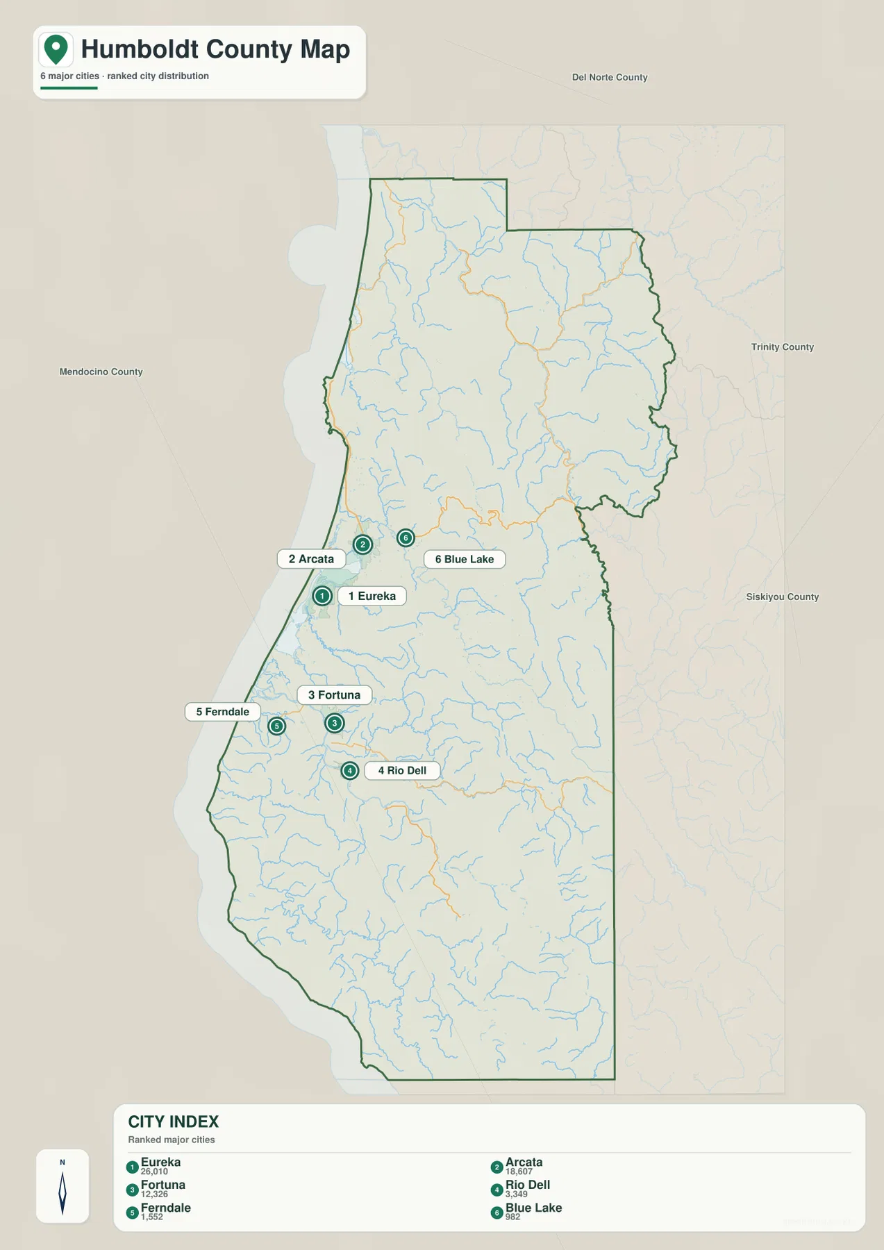
Humboldt County’s official resources identify seven incorporated cities: Arcata, Blue Lake, Eureka, Ferndale, Fortuna, Rio Dell, and Trinidad. The ranked graphic shows six of the larger cities and does not include Trinidad. Important unincorporated communities such as McKinleyville, Hoopa, and Willow Creek also appear only on the broader reference map, so the city graphic should not be treated as a complete settlement inventory.
The Klamath and Trinity rivers organize the northern and eastern mountains
The Klamath River is the strongest water feature across northern Humboldt County. It cuts westward through rugged terrain, while the Trinity River approaches from the east and joins the larger Klamath system within the northern interior. Locating these two rivers makes the Hoopa–Willow Creek side of the county much easier to understand.
The Trinity River follows a long, winding mountain valley. Humboldt County maintains a dedicated Trinity River water-management page, reflecting the river’s importance to the county. On the supplied terrain map, the river is surrounded by closely spaced ridges and numerous tributaries, a setting very different from the wider coastal lowlands around Eureka and Arcata.
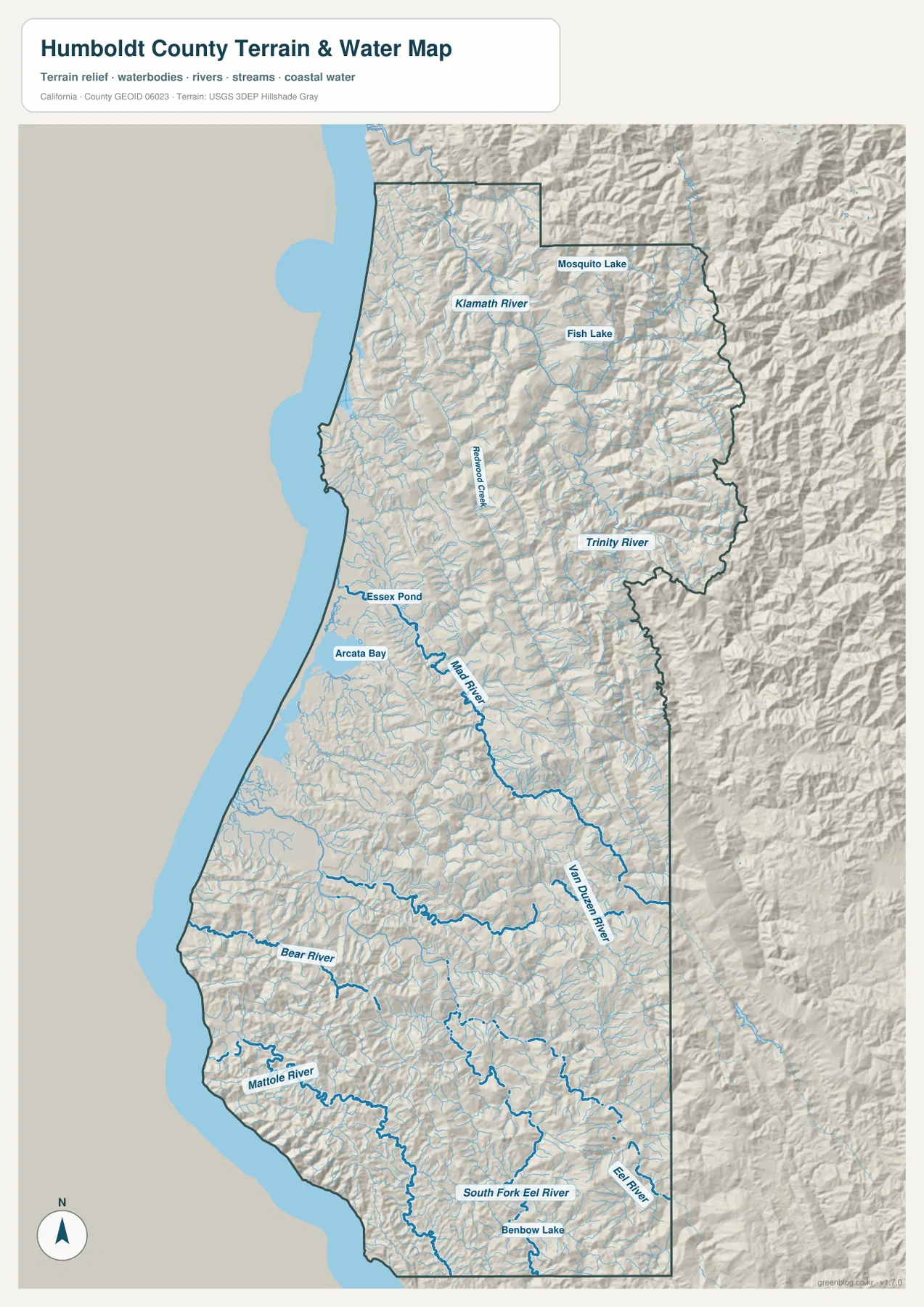
Fish Lake and Mosquito Lake provide smaller landmarks in the northern mountain region, while Redwood Creek is labeled closer to the coast. The National Park Service describes Redwood National and State Parks as protecting old-growth coast redwood forests together with streams, prairies, seashore, and woodlands. That combination fits the northern Humboldt landscape shown here, where forested relief and river drainage occupy far more space than developed areas.
Mad River and Humboldt Bay explain the coastal concentration around Arcata and Eureka
The central coast has a very different water pattern from the northern mountains. Mad River descends from inland hills toward the coast north of the main Humboldt Bay area, while Arcata Bay is labeled directly on the terrain map. Eureka and Arcata sit beside the broadest coastal water and lowland area shown in the county.
Humboldt County’s current overview calls Humboldt Bay California’s second-largest natural bay and the only deep-water port between San Francisco and Coos Bay, Oregon. That official context helps explain why the bay area stands out as the county’s primary urban concentration. The map shows that major roads and communities gather around this lower coastal setting before the terrain rises quickly inland.
The relationship between Arcata, McKinleyville, Route 299, U.S. 101, and Mad River is especially useful for orientation. The road map provides the settlement pattern, while the terrain map shows the underlying lowland and drainage setting. Humboldt County GIS also makes official road, stream, coastal-zone, and topographic layers available but warns that its GIS data should not be treated as legal boundary or project-design information.
The Eel and Van Duzen rivers define much of the southern interior
The Eel River is the dominant river system in southern Humboldt County. On the terrain map, the Eel River and South Fork Eel River occupy long mountain valleys, while the Van Duzen River approaches from the east through another major drainage corridor. These rivers are more useful than towns for understanding much of the southern interior.
State Route 36 runs east from the Rio Dell side into the Van Duzen country. U.S. 101 and Route 254 are more closely associated with the north–south Eel River corridor. The roads do not exactly duplicate the rivers, but both transportation and drainage are strongly shaped by the same valleys and ridges, which is clear when the reference and terrain maps are compared.
Humboldt Redwoods State Park provides a well-known local example along the South Fork Eel River. California State Parks emphasizes the Avenue of the Giants and the park’s vast old-growth redwood forest. On the county map, this southern area contains fewer large city labels but a dense combination of river channels, tributaries, and forested mountain relief. Benbow Lake appears near the southern end as a useful small water reference.
The Mattole and Bear rivers mark a remote southwestern coastal landscape
Southwestern Humboldt County is much less urban than the Humboldt Bay or Fortuna areas. The Mattole River follows a long, curving route through coastal mountains before reaching the Pacific, while Bear River occupies a separate drainage farther north. The terrain around both rivers is strongly shaded and cut by many smaller tributaries.
The reference map contains very few large settlement labels in this southwestern section. Roads are sparse and winding, and the county’s Pacific boundary runs beside rugged coastal hills for a long distance. Humboldt County’s overview notes approximately 110 miles of coastline and describes more than 80 percent of the county as forestland, protected redwoods, and recreational areas, which provides useful context for the large undeveloped regions visible on the map.
No separate elevation map is included in this package, but the terrain shading clearly shows the difference between lower coastal and river-bottom areas and the surrounding mountains. Exact elevations or slopes should be checked with dedicated USGS elevation data rather than inferred from this generalized county-scale relief image.
Use U.S. 101 and the three major river regions to organize the county
A practical first pass is to follow U.S. 101 through McKinleyville, Arcata, Eureka, Fortuna, and Rio Dell. This establishes the coast and southern settlement corridor. Next, follow Route 299 from Arcata to Willow Creek and Route 96 toward Hoopa to understand how the map reaches into the eastern mountain interior.
On the terrain map, divide the county into three broad river regions: Klamath–Trinity in the north and east, Mad River–Humboldt Bay around the central coast, and Eel–Van Duzen in the south. The Mattole River then adds the remote southwestern coastal drainage. This method ties place names to real valleys and makes the large county easier to read without memorizing every small road or stream.
Choose the file according to whether you need settlements, roads, or river-and-redwood terrain
The county reference map is the best starting point for Eureka, Arcata, Fortuna, Rio Dell, Willow Creek, Hoopa, highways, and the county boundary. The ranked city map is useful when the relative size and location of the six largest mapped cities are the main questions. The terrain-and-water image provides the strongest view of the Klamath, Trinity, Mad, Eel, Van Duzen, and Mattole rivers, Arcata Bay, mountain valleys, and the long Pacific coast.
For teaching or regional explanation, the reference and terrain maps work especially well together. Eureka and Arcata can be placed around Humboldt Bay, Willow Creek and Hoopa can be connected with the Trinity River mountains, and Fortuna–Rio Dell can be shown within the Eel River corridor. Farther south, the same comparison explains why the Avenue of the Giants and redwood country follow a river-and-valley landscape rather than a broad urban plain.
Each downloadable JPG measures 2572 × 3638 pixels and is suitable for A3 portrait printing, enlarging small place labels, or placing a map in a report or classroom handout. Keep the original aspect ratio when resizing so roads, rivers, and the county outline are not distorted. Printer margins vary, so checking one test page before a larger print run is useful.
Frequently Asked Questions
What is the county seat of Humboldt County, California?
Eureka is the county seat. Humboldt County’s official overview identifies Eureka as the seat of government, and the reference map shows it as the largest developed coastal area just south of Arcata around Humboldt Bay.
How do the Trinity and Klamath rivers relate on the map?
The Trinity River travels through the eastern mountain interior and joins the larger Klamath River system in northern Humboldt County. Hoopa and Willow Creek provide useful nearby settlement references for following these deep river valleys on the terrain map.
Does this download include a separate elevation map?
No. This Humboldt County package contains the county reference map, city-distribution map, and terrain-and-water map. Relief shading shows the difference between coastal lowlands and inland mountains, but no separate numeric elevation map is included.
Map File Information
The ZIP contains the original Humboldt County reference, city-distribution, and terrain-and-water maps as high-resolution JPG files.
- Included Files: County reference map, city-distribution map, terrain-and-water map
- Printable Size: 2572 × 3638 pixels each
- File Type: Three high-resolution JPG files in one ZIP archive
Related Maps
Sources and References
- Humboldt County – County Overview – Official county information on Eureka, Humboldt Bay, major communities, coastline, forests, and regional geography.
- Humboldt County Web GIS – Official mapping resources for roads, streams, coastal areas, topography, and jurisdiction boundaries.
- Humboldt County – Trinity River – Official county information on Trinity River water management and regional importance.
- California State Parks – Humboldt Redwoods State Park – Official information on the Avenue of the Giants, old-growth redwoods, and South Fork Eel River country.
- National Park Service – Redwood National and State Parks – Official background on North Coast redwood forests, streams, prairies, seashore, and woodlands.
Green Map creates custom-edited map images using open geographic data sources such as geoBoundaries, Natural Earth, OpenStreetMap, and government open data.
These maps are edited visual materials, not raw data files, and are provided for education, documents, presentations, and graphic reference.