Kings County lies in the southern San Joaquin Valley, where an extremely flat agricultural basin covers most of the county and low western hills rise near Avenal and the Monterey County side. Hanford, the county seat, and Lemoore form the main northern urban pair. Corcoran lies farther south in the Tulare Lake Basin, while Avenal occupies the southwestern edge where the terrain begins to climb. The Kings River enters near the northeast, and a dense network of river branches, ditches, canals, and flood channels spreads across the valley floor.
Download the original high-resolution A3 JPG files from this Kings County California Map page in one ZIP. The package contains a county reference map, ranked city-distribution map, and terrain-and-water map. There is no separate elevation map in the supplied bundle, so descriptions of the Tulare Lake lowland and western hills rely on the visible relief shading and on verified Kings County geographic information.
Table of Contents
Hanford is the county seat and Highway 198 links it directly with Lemoore
Kings County’s official About Us page identifies Hanford as the county seat. On the reference map, Hanford is the largest developed area in the north-central part of the county, with Lemoore a short distance to the west. State Route 198 runs directly between them, making the road the easiest first reference for the county’s two largest urban centers.
Highway 43 passes east of Hanford and continues south toward the Corcoran side, while Highway 41 crosses the Lemoore area from north to south. Grangeville and Hardwick appear north and west of Hanford as smaller community references. The surrounding valley is remarkably flat, so roads and irrigation channels follow long, straight lines that look very different from the southwestern hill country.
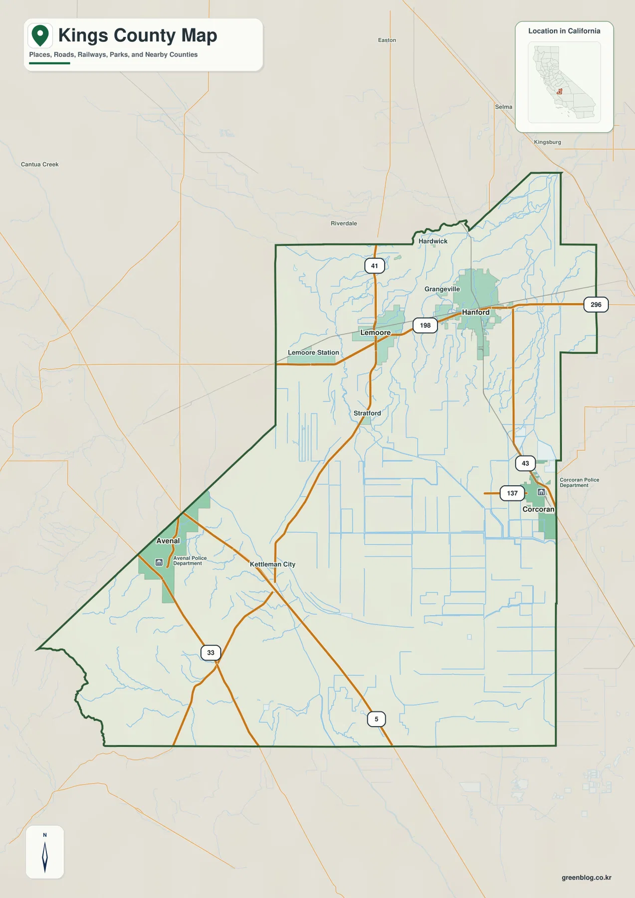
The county’s official general-information page lists Interstate 5 and Highways 41, 43, 33, and 198 among the major roads. Each serves a distinct part of the map. Highway 198 is the clearest Hanford–Lemoore route, Highway 43 leads toward Corcoran, and Highways 33 and 41 help organize the Avenal–Kettleman City side. Interstate 5 forms the principal long-distance corridor through the southwestern county.
Lemoore and Lemoore Station form a separate Highway 198 center west of Hanford
Lemoore is the second-largest city on the supplied city graphic, and Lemoore Station is labeled separately on the reference map to the west. The U.S. Navy’s official Naval Air Station Lemoore page places the installation on Highway 198, about nineteen miles east of Interstate 5 and thirty miles west of Highway 99. This gives the Lemoore Station label a clear county-specific meaning rather than treating it as just another rural place name.
Highway 198 continues east from the air-station side through Lemoore toward Hanford. Stratford lies south of Lemoore within a landscape filled with narrow canals and farm roads. The map outside the city limits is overwhelmingly agricultural, which matches the Navy’s description of NAS Lemoore as an installation surrounded by sparsely populated farming land.
This part of the county is also a good example of why the reference map matters beyond municipal boundaries. Hanford and Lemoore provide the obvious city names, but Lemoore Station, Stratford, Grangeville, and Hardwick add important local context that a ranked city graphic cannot show.
Hanford leads the city ranking, followed by Lemoore, Corcoran, and Avenal
The supplied city-distribution graphic shows all four incorporated cities in Kings County. Hanford is ranked first at 59,754, Lemoore second at 27,102, Corcoran third at 22,491, and Avenal fourth at 13,608. These are comparison values printed on the supplied image rather than the newest Census estimates, so current demographic work should use an official statistical source.
The geographic pattern is more revealing than the ranking alone. Hanford and Lemoore sit close together in the northern valley, Corcoran is well to the southeast, and Avenal is isolated along the southwestern edge near hillier terrain. The city map therefore separates the county into a northern urban pair and two much more widely spaced southern cities.
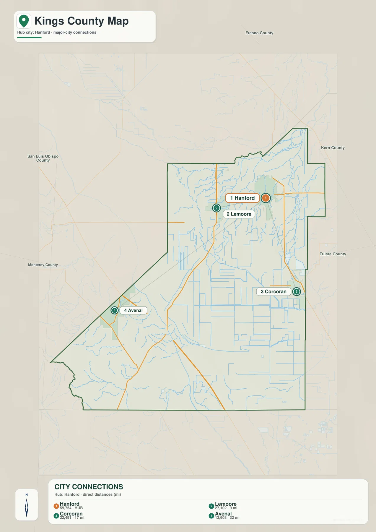
Kings County General Plan material identifies the same four cities—Avenal, Corcoran, Hanford, and Lemoore—and also lists unincorporated community areas such as Kettleman City and Stratford. The city graphic is therefore complete for incorporated municipalities but intentionally incomplete for local settlement geography. The reference map should be used when those smaller communities matter.
The Kings River and South Fork spread water across the northeastern valley
The Kings River gives the county its name and is one of the strongest features on the terrain-and-water map. Kings County planning material says the river runs along the northern edge and then flows south toward the county interior; historically, its water continued toward Tulare Lake. On the supplied map, the Kings River appears near the northeast edge and the South Fork Kings River bends west and south across the valley.
A dense group of irrigation features branches around the South Fork. Riverside Ditch, Last Chance Ditch, East Branch People’s Ditch, People’s Ditch, Wige Canal, and several smaller channels are labeled in the northern and eastern valley. The result is not a simple river corridor but a broad agricultural water-distribution landscape surrounding the Hanford and Lemoore side of the county.
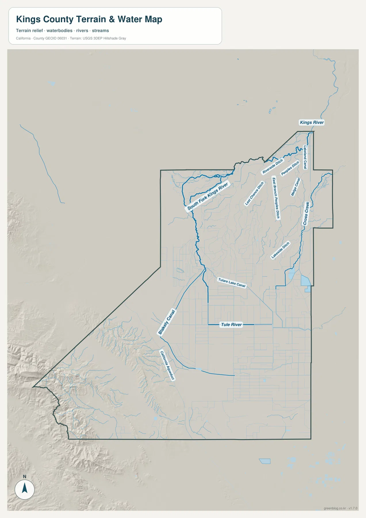
Kings County’s general-information page lists the Kings, Tule, Kaweah, and Kern rivers and the California Aqueduct among county water sources. The current preview directly labels the Kings River and Tule River together with many canals and ditches. Staying with features that actually appear on the supplied image keeps the article useful without turning the water section into a list of sources that cannot be seen on the map.
Cross Creek and the Tule River drain toward the historic Tulare Lake Basin
Cross Creek is labeled along the eastern side of the terrain map, while the Tule River crosses the southern valley. Kings County’s Resource Conservation Element explains that the historic Tulare Lake Basin once received drainage from the upper Kings River watershed as well as Cross Creek, the Tule River, and the Kern River. The supplied map reflects that low-basin geometry, with several channels trending toward the broad southern interior.
The Tulare Lake Canal and Blakely Canal are particularly useful landmarks in the southern half. Their straighter shapes stand out against the more natural curves of river channels, and they cross a very smooth agricultural landscape. Corcoran Reservoir is also labeled near the southeastern city area, reinforcing the importance of managed water infrastructure in this part of the county.
The historic lake bed should not be described simply as a vanished lake. Kings County’s 2023 Hazard Mitigation Plan notes that the Tulare Lake Basin remains a major flood-prone area and can serve as an emergency overflow basin during extreme high-water years. Much of the land is used for agriculture, but the low topography still matters whenever unusually large volumes of water reach the valley.
Corcoran sits inside the dense canal network of the southern lowland
Corcoran lies in the southeastern part of Kings County near Highways 43 and 137. On the reference map, the city is surrounded by an unusually dense network of straight waterways and agricultural lines. Relief shading is minimal, which is consistent with the city’s location on the flat Tulare Lake Basin side of the county.
Cross Creek lies to the east, while the Tule River, Tulare Lake Canal, Blakely Canal, and Corcoran Reservoir provide additional southern water references. The city is far enough from Hanford and Lemoore that it reads as a separate southern center rather than an extension of the northern urban pair.
The terrain map should not be used as a flood-hazard or levee-condition map. Kings County planning and hazard documents make clear that the Tulare Lake Basin and major channels such as Cross Creek remain important for flood management. Current road, property, or safety decisions should therefore use up-to-date county, FEMA, and California water-agency information.
Avenal and Kettleman City mark the transition from valley floor to western hills
The southwestern corner looks different from nearly every other part of Kings County. Avenal sits near the western boundary, while Kettleman City lies farther northeast near Highway 41, Highway 33, and Interstate 5. The terrain map shows stronger relief west and southwest of these places, marking the transition from the flat Tulare Lake Basin toward the Kettleman Hills and the Monterey County side.
Kings County’s official About Us page gives an elevation range from about 175 feet near Tulare Lake to roughly 3,500 feet at the Kings–Monterey county boundary. Those figures come from county information rather than a missing elevation layer. The supplied relief map is best used to see the broad contrast: central and southeastern Kings County are extremely flat, while the far southwest rises into much rougher ground.
Interstate 5 crosses this southwestern region as a long-distance highway, while Highway 33 helps connect Avenal and Kettleman City. This road pattern differs from the Hanford–Corcoran side, where local agricultural roads and canals dominate. The contrast makes Avenal especially useful when explaining that Kings County is not entirely featureless valley floor.
Use Hanford as the anchor, then separate the Tulare Lake Basin from the western uplands
A practical first pass is to locate Hanford and follow Highway 198 west to Lemoore. Highway 43 then provides a simple route south toward Corcoran. For the southwest, Avenal and Kettleman City can be organized around Highways 33 and 41 and Interstate 5. This road-based approach establishes the county’s four city areas before adding the much denser water network.
On the terrain map, begin with the Kings River in the northeast and follow the South Fork into the agricultural valley. Then locate Cross Creek and the Tule River farther south, followed by Tulare Lake Canal and Blakely Canal in the basin. Finally, compare those flat channels with the stronger relief near Avenal. This sequence explains the county far more clearly than memorizing a long list of canals.
Choose the map according to whether you need communities, highways, or basin waterways
The county reference map is the best starting point for Hanford, Lemoore, Corcoran, Avenal, Kettleman City, Stratford, highways, and the county boundary. The city-distribution graphic gives a clean comparison of all four incorporated cities. The terrain-and-water map is the strongest choice for the Kings River, South Fork Kings River, Cross Creek, Tule River, Tulare Lake canals, Corcoran Reservoir, and the western hill transition.
For teaching or regional explanation, the reference and terrain maps work especially well together. Hanford and Lemoore can be connected with Highway 198 and the northern irrigation network, while Corcoran can be placed inside the historic Tulare Lake Basin. Avenal and Kettleman City then provide a clear southwestern contrast where flat agricultural land begins to rise toward the hills.
Each downloadable JPG measures 2572 × 3638 pixels and is suitable for A3 portrait printing, enlarging small place and canal labels, or placing a map in a report or classroom handout. Keep the original aspect ratio when resizing so roads, rivers, canals, and the county outline are not distorted. Printer margins vary, so checking one test page before a larger print run is useful.
Frequently Asked Questions
What is the county seat of Kings County, California?
Hanford is the county seat. Kings County’s official About Us page identifies Hanford as the seat of government. On the reference map, it is the largest city in the north-central valley, east of Lemoore and north of Corcoran.
How does the Kings River relate to the Tulare Lake Basin?
Kings County planning documents explain that the Kings River historically drained toward Tulare Lake, together with channels such as Cross Creek and the Tule River. The modern map shows the Kings River and South Fork in the north and a large canal-and-drainage network extending toward the low Tulare Lake Basin.
Does this download include a separate elevation map?
No. This Kings County package contains the county reference map, city-distribution map, and terrain-and-water map. Relief shading shows the contrast between the flat Tulare Lake Basin and the southwestern hills near Avenal, but no separate numeric elevation map is included.
Map File Information
The ZIP contains the original Kings County reference, city-distribution, and terrain-and-water maps as high-resolution JPG files.
- Included Files: County reference map, city-distribution map, terrain-and-water map
- Printable Size: 2572 × 3638 pixels each
- File Type: Three high-resolution JPG files in one ZIP archive
Related Maps
Sources and References
- Kings County – About Us – Official county information on Hanford as the county seat, major roads, agriculture, land area, and elevation.
- Kings County General Plan – Introduction – Official context for the Kings River, Tulare Lake Basin, four incorporated cities, and county geography.
- Kings County General Plan – Resource Conservation Element – Official discussion of the Kings River, Cross Creek, Tule River, Tulare Lake Basin, and floodwater conveyance.
- U.S. Navy – Naval Air Station Lemoore – Official information on NAS Lemoore and its Highway 198 location west of Lemoore.
- Kings County GIS – Official county GIS resources for boundaries, communities, streets, and mapping layers.
Green Map creates custom-edited map images using open geographic data sources such as geoBoundaries, Natural Earth, OpenStreetMap, and government open data.
These maps are edited visual materials, not raw data files, and are provided for education, documents, presentations, and graphic reference.