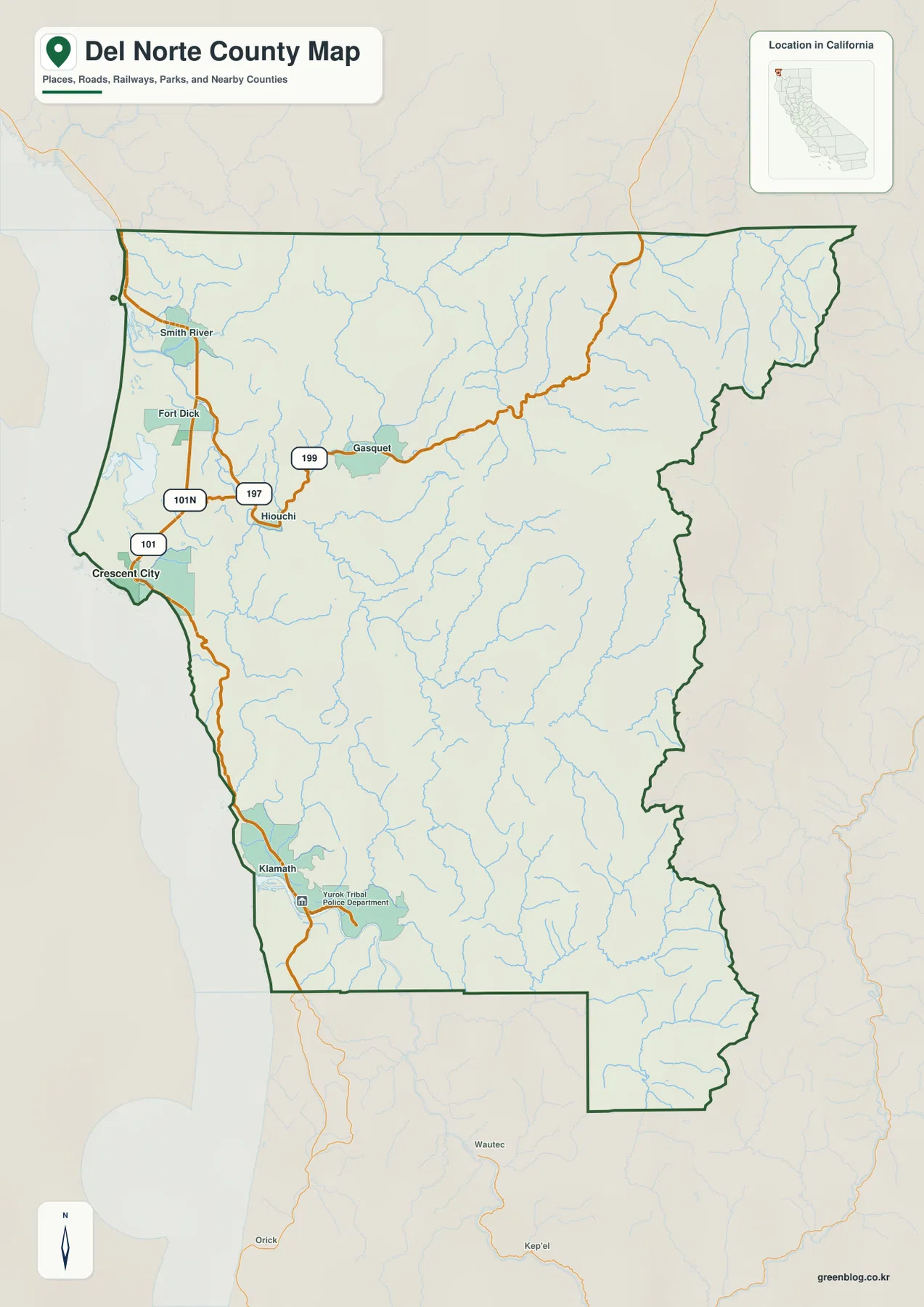
Del Norte County occupies California’s far northwestern corner, where a narrow Pacific coastal plain meets the rugged Klamath Mountains. Crescent City is the county seat and the main population center on the coast. Smith River and Fort Dick lie to the north, Hiouchi and Gasquet follow the inland Smith River corridor, and Klamath sits along U.S. 101 in the southern coastal section. Much of the county away from the coast is mountainous, deeply cut by streams, and sparsely settled.
You can download the original high-resolution A3 JPG files from this Del Norte County Map page in one ZIP. The package contains a county reference map, city-distribution map, and terrain-and-water map. There is no separate elevation map in this package, so descriptions of higher and lower ground rely on the visible relief shading and verified county geography rather than an unsupported elevation layer.
Table of Contents
Crescent City anchors the coast and U.S. 101 organizes north–south travel
Crescent City is the county seat and the only incorporated city in Del Norte County, according to the county’s official website. On the reference map it is the largest developed area on the Pacific coast. Fort Dick and Smith River lie to the north, while U.S. 101 continues south toward Klamath. Starting with Crescent City makes the county’s narrow coastal settlement pattern easy to understand.
U.S. 101 is the clearest road reference along the western side. It passes Crescent City, continues north toward the Smith River area, and runs south along the coast toward Klamath and Humboldt County. Much of the developed land is close to this corridor, while mountainous terrain rises quickly to the east. The result is a county where a major highway and the Pacific shoreline occupy a relatively narrow strip beside a much larger rugged interior.
The northwestern corner around Fort Dick and Smith River contains one of the broader lowland areas visible on the map. Del Norte County’s 2024 Community Health Assessment describes the county as California’s far northwestern corner and identifies Crescent City as its largest population center. East of the coastal settlements, the terrain becomes noticeably more broken and road density drops quickly.
U.S. 199 follows the Smith River corridor through Hiouchi and Gasquet
The main inland route in northern Del Norte County is U.S. 199. From the coastal side it approaches Hiouchi, continues through Gasquet, and then climbs deeper into mountain country toward the northeastern edge. Route 197 provides another connection between the coastal road system and the Smith River corridor. The reference map shows these roads bending with the valleys rather than crossing the mountains in straight lines.
Hiouchi sits close to the Smith River and serves as a recognizable midpoint between Crescent City and Gasquet. The National Park Service places the Jedediah Smith Visitor Center in Hiouchi near the river, reinforcing the area’s role as a gateway to the redwood and river landscape. Gasquet lies farther east where streams and steep ridges become much more prominent.
Beyond Gasquet, major settlement labels nearly disappear. The road and stream network continues through rugged terrain toward the county’s northeastern boundary. In this part of Del Norte County, rivers and mountain valleys are more useful for orientation than towns, a pattern that becomes even clearer on the terrain-and-water map.
The city map contains one ranked municipality: Crescent City
The supplied city-distribution graphic is unusually simple. It shows Crescent City as the single ranked major city, with a printed value of 6,046. That number is best treated as a comparison figure used in the supplied image rather than the newest population estimate. Current demographic work should use the Census or another official statistical source.
The simple graphic reflects the county’s municipal structure. Del Norte County’s official links page states that Crescent City is the only incorporated city in the county. Smith River, Fort Dick, Hiouchi, Gasquet, and Klamath are important local communities on the reference map, but they do not appear as incorporated cities in the ranked view.
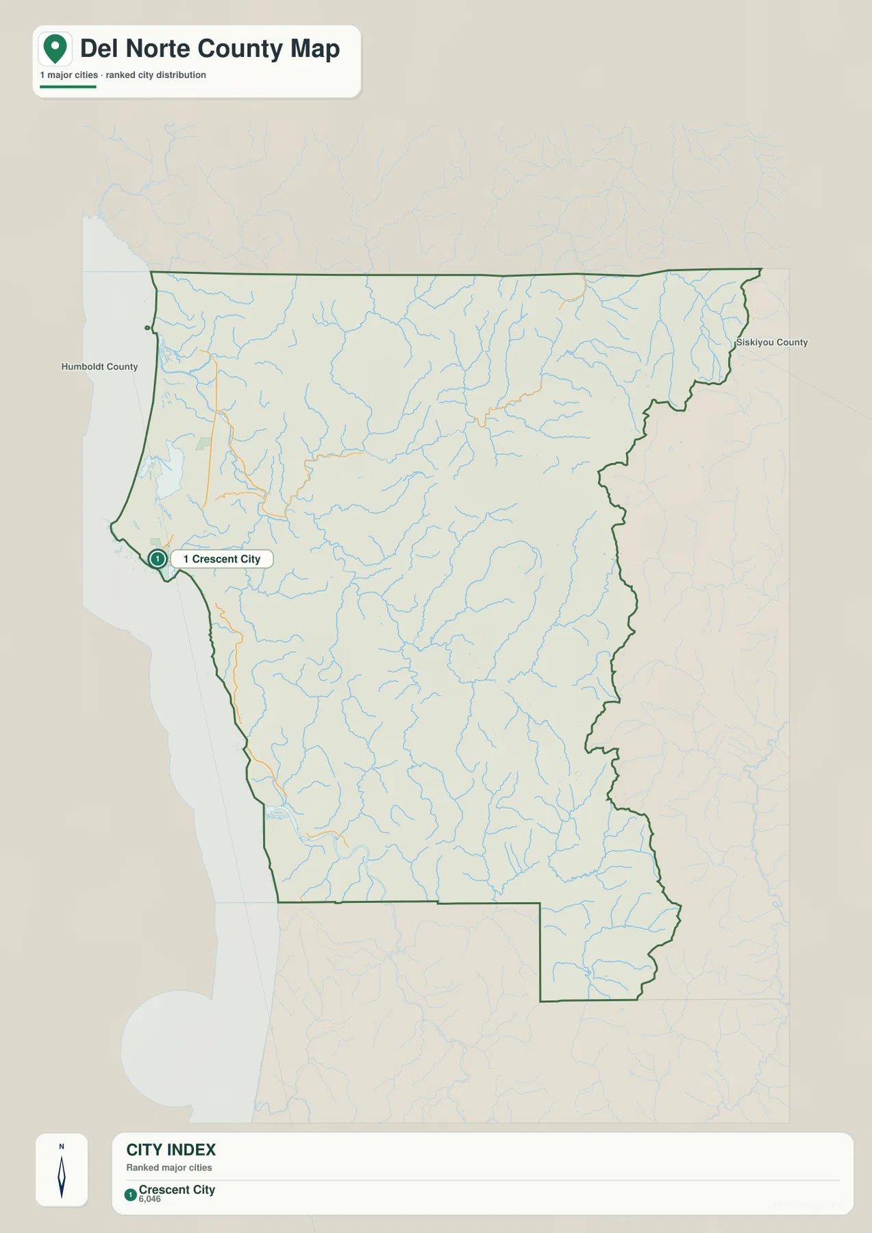
For that reason, the city graphic should be used for one narrow question: where the incorporated urban center is located. The county reference map is much more important for understanding actual travel and local geography because most of Del Norte County’s named communities are outside an incorporated municipality.
The Smith River and its forks divide the northern mountains into major valleys
The Smith River is the dominant water feature in northern Del Norte County. Near the coast, the main river reaches the Pacific, while farther inland the terrain map labels the North Fork, Middle Fork, and South Fork Smith River. Each branch occupies a separate mountain valley, creating a large branching drainage network across the northern half of the county.
The North Fork descends through the northern interior. The Middle Fork runs westward through the Gasquet side, while the South Fork follows a much longer route through the central-southern mountains before turning toward the main river system. The branches do not form a simple straight pattern; they curve around ridges and occupy deep valleys, which also helps explain the winding path of U.S. 199.
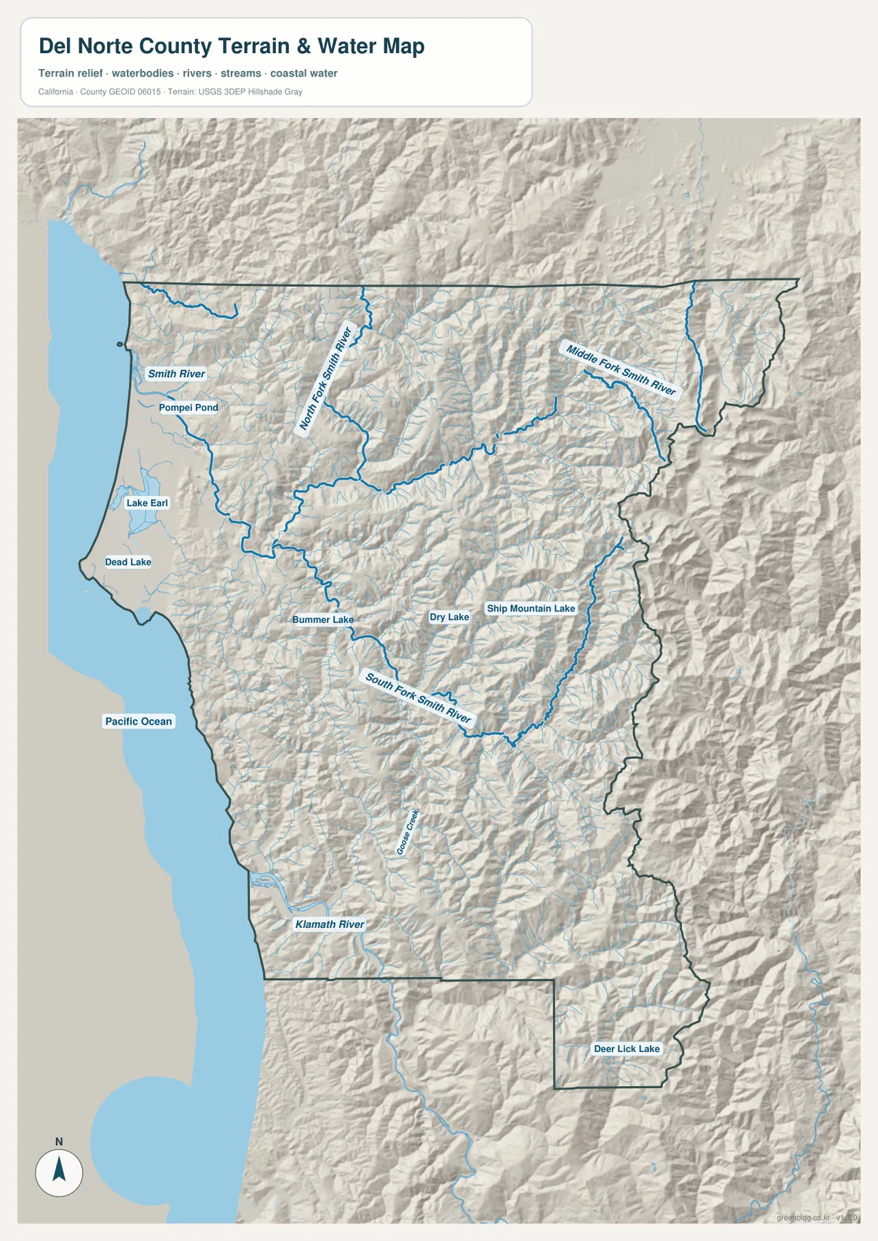
The U.S. Forest Service’s Smith River National Recreation Area material provides useful context for this northern watershed and the Gasquet area. It treats the Smith River corridor as a major mountain and river landscape within Six Rivers National Forest. The supplied map shows the same broad pattern: few large settlements, many tributaries, and relief that is much rougher than the coastal lowland around Crescent City.
The Klamath River reaches the Pacific through the southern coastal mountains
Southern Del Norte County is organized around the Klamath River. Klamath is labeled along U.S. 101 near the coast, and the terrain map shows the river emerging from the interior before reaching the Pacific. The surrounding relief is steep, so the river valley forms a major opening through otherwise rugged coastal mountains.
The National Park Service describes Redwood National and State Parks as extending for roughly 50 miles along the northern California coast from Crescent City toward the Redwood Creek watershed south of Orick. The park system includes major rivers and about 37 miles of coastline. Del Norte County’s southern Klamath and redwood landscape fits directly into that larger North Coast setting.
California State Parks describes Del Norte Coast Redwoods State Park, just south of Crescent City, as a steep coastal landscape where redwood forest meets eight miles of wild coastline. That setting is easy to recognize on the terrain map: ridges rise close to the Pacific, and there is no broad continuous coastal plain extending through the entire county.
Lake Earl and small mountain lakes show how the coastal lowlands differ from the interior
Several smaller water bodies provide useful landmarks beyond the major rivers. Lake Earl and Dead Lake are labeled near the coastal lowlands north of Crescent City, while Pompei Pond appears closer to the Smith River side. These waters sit in a much gentler setting than the steep interior drainages farther east.
In the mountains, Bummer Lake, Dry Lake, and Ship Mountain Lake appear as isolated inland water bodies, with Deer Lick Lake farther southeast. Because settlement labels are sparse in those areas, the lakes can help with orientation on a county-scale map. They should not, however, be treated as evidence of public access, road conditions, or recreation availability.
This terrain-and-water image is a geographic reference, not a flood-hazard, parcel, navigation, or water-quality map. Del Norte County GIS similarly warns that its online mapping data are not legal documents and may change over time. Use the map to understand the relative position of rivers, lakes, roads, and terrain, and consult the responsible agency for current safety or property decisions.
A narrow coastal plain gives way quickly to the Klamath Mountains
There is no separate elevation map in this package, but the relief shading makes the county’s height difference unmistakable. Crescent City, Fort Dick, and the Smith River coastal area occupy relatively small patches of lower ground. East of them, ridges become closely spaced and river valleys cut deeply through the Klamath Mountains.
Official Del Norte County material describes mountainous terrain associated with the Coast Range and Klamath Mountains as the dominant physical setting. The same county source reports elevations from sea level to more than 6,400 feet, with flatter land limited mainly to coastal areas and isolated mountain valleys. Those numbers come from the county document rather than from a missing elevation layer in this map package.
California State Parks provides another local example south of Crescent City. Del Norte Coast Redwoods State Park rises steeply from sea level to about 1,277 feet, with cliffs close to the Pacific. That park-scale description reinforces what the county terrain map shows across a much larger area: coastline, forested slopes, and mountain relief are tightly packed together.
Start with Crescent City and the Smith River corridor before reading the mountain interior
A practical first pass is to begin at Crescent City and use U.S. 101 to establish the coast. Smith River and Fort Dick lie to the north, while Klamath is to the south. Once those coastal references are clear, U.S. 199 can be followed east through Hiouchi and Gasquet to show how quickly the county moves from low coastal ground into mountain valleys.
On the terrain map, locate the Smith River main stem and then trace the North, Middle, and South Forks into the interior. Farther south, the Klamath River provides another strong landmark. Lake Earl and Dead Lake help identify the coastal lowland. Because Del Norte County has few large towns, combining rivers and highways is much more useful than relying on settlement names alone.
Choose the file according to whether you need communities, roads, or river-and-mountain detail
The county reference map is the best starting point for Crescent City, Smith River, Fort Dick, Hiouchi, Gasquet, Klamath, highways, and the county boundary. The city-distribution graphic is useful for showing the county’s single incorporated city. The terrain-and-water image provides the strongest view of the Smith River forks, Klamath River, coastal lakes, Pacific shoreline, and deeply dissected interior mountains.
For teaching or regional explanation, the reference and terrain maps work especially well together. Crescent City and Fort Dick can be placed on the narrow coastal lowland, while Hiouchi and Gasquet show the transition into the Smith River mountains. Around Klamath, the road and water views make it easy to connect U.S. 101 with the river mouth and steep coastal terrain.
Each downloadable JPG measures 2572 × 3638 pixels and is suitable for A3 portrait printing, enlarging small place labels, or placing a map in a report or classroom handout. Keep the original aspect ratio when resizing so roads, rivers, and the county outline are not distorted. Printer margins vary, so checking one test page before a larger print run is useful.
Frequently Asked Questions
What is the county seat of Del Norte County?
Crescent City is the county seat and the county’s only incorporated city. On the reference map it is the main coastal center between the Smith River–Fort Dick area to the north and Klamath to the south.
How should I follow the Smith River on the map?
Start with the main Smith River near the coast, then trace the North Fork, Middle Fork, and South Fork into the mountain interior. The branching river system is one of the best guides to the northern half of Del Norte County.
Does this download include a separate elevation map?
No. This Del Norte County package contains the county reference map, city-distribution map, and terrain-and-water map. Relief shading shows the contrast between the coastal lowlands and Klamath Mountains, but no separate numeric elevation map is included.
Map File Information
The ZIP contains the original Del Norte County reference, city-distribution, and terrain-and-water maps as high-resolution JPG files.
- Included Files: County reference map, city-distribution map, terrain-and-water map
- Printable Size: 2572 × 3638 pixels each
- File Type: Three high-resolution JPG files in one ZIP archive
Related Maps
Sources and References
- Del Norte County – Website Links – Official county page identifying Crescent City as the county’s only incorporated city.
- Del Norte County GIS – Official county mapping resources and data-use disclaimer.
- National Park Service – Redwood National and State Parks – Official information on the North Coast redwood landscape, major rivers, and coastline near Crescent City.
- California State Parks – Del Norte Coast Redwoods State Park – Official information on the steep redwood-covered coastline south of Crescent City.
- U.S. Forest Service – Smith River National Recreation Area Map & Guide – Official map and guide for the Smith River watershed and Gasquet mountain region.
Green Map creates custom-edited map images using open geographic data sources such as geoBoundaries, Natural Earth, OpenStreetMap, and government open data.
These maps are edited visual materials, not raw data files, and are provided for education, documents, presentations, and graphic reference.