White County spans a major terrain transition in north-central Arkansas. Searcy sits near the middle of the county, where the higher western landscape begins to give way to broad lowlands toward the White River. Judsonia and Bald Knob extend the main settlement pattern to the northeast, while Beebe is a large southern reference point along the highway corridor. The Little Red River passes through the Searcy area and continues east across progressively flatter ground before joining the White River.
Download the original high-resolution A3 JPG files from this White County Arkansas Map set in one ZIP near the end of the page. The maps let you compare Searcy and the main road network with the Little Red River, smaller creeks and lakes, and the strong elevation difference between the western uplands and the eastern alluvial plain. The county is especially useful for seeing how settlement, transportation, and rivers change across that transition.
Table of Contents
Searcy anchors the main settlement corridor through central White County
Searcy is the county seat and the largest place shown on the reference map. Harding University is labeled near the city, and several major routes converge through the surrounding developed area. The Encyclopedia of Arkansas describes Searcy as the county’s largest population and industrial center, which matches the much denser concentration of streets and facilities visible on the map.
North of Searcy, Judsonia appears along the same general transportation corridor, with Bald Knob farther northeast. Kensett and Higginson lie close to Searcy and Judsonia on the southeastern side of the central cluster. These communities form a relatively compact sequence compared with the much more sparsely labeled uplands in the western half of the county.
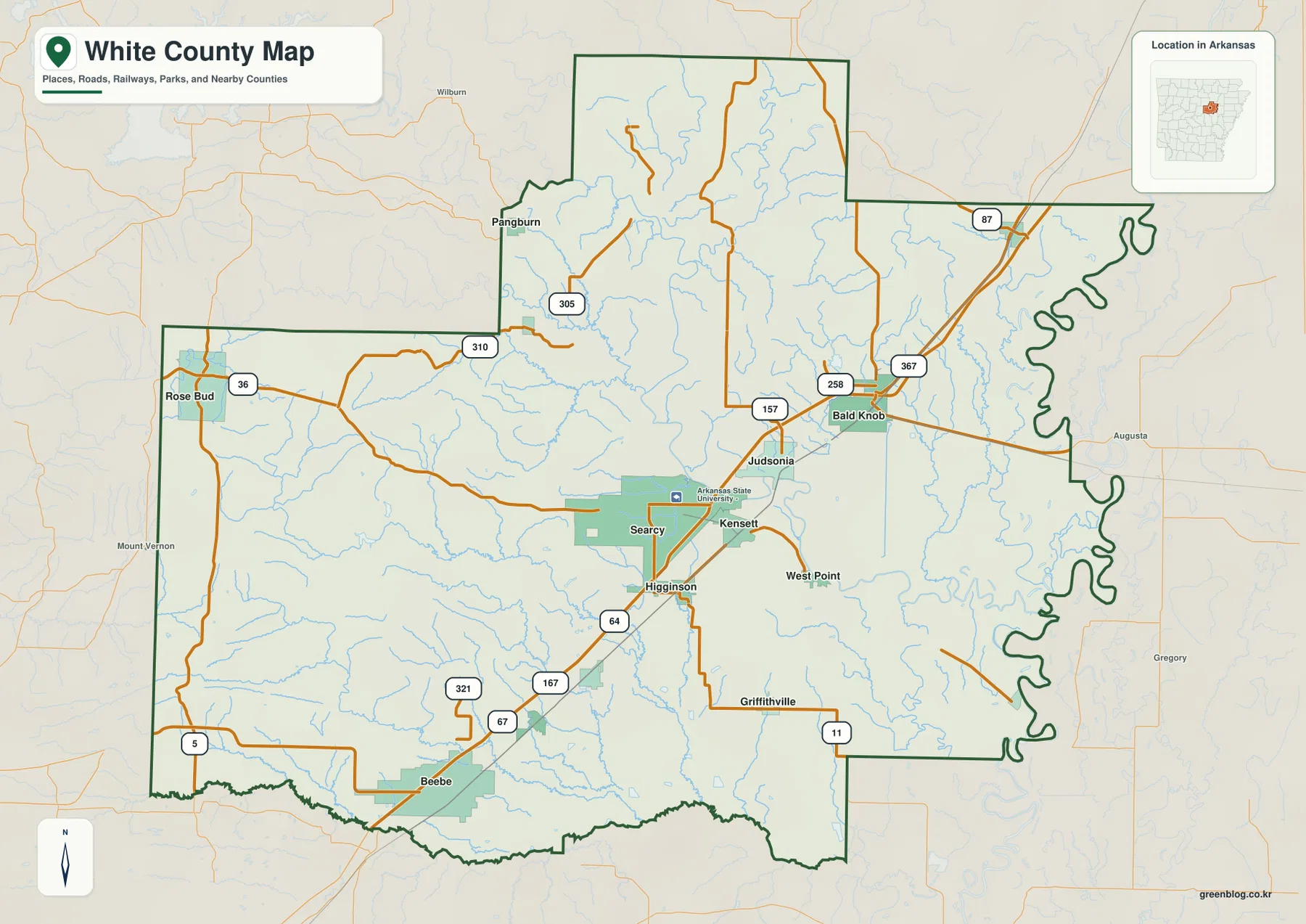
Beebe creates a second major orientation point in the southwest. U.S. 67 and U.S. 167 connect the Beebe area toward Searcy, passing the Higginson and Kensett side of the county. Rose Bud lies well to the west, while Pangburn is farther northwest. Their positions show that White County is not simply a highway strip: large rural areas, smaller roads, and broken upland terrain occupy much of the west.
The eastern boundary looks very different from the straighter western and southern edges. It follows a strongly meandering river corridor, with Augusta labeled on the opposite side in the surrounding map context. That winding edge is an important clue when deciding whether a road, lake, or small stream lies inside White County or just beyond it.
The city view separates Searcy and Beebe from the smaller northeastern towns
The ranked city graphic removes much of the road detail and makes the relative size and spacing of the major communities easier to compare. Searcy is listed first, followed by Beebe. Bald Knob, Judsonia, Kensett, and Higginson complete the six-place view. The map immediately shows Searcy as the central anchor and Beebe as a large but more distant city to the southwest.
Bald Knob and Judsonia are positioned northeast of Searcy, while Kensett and Higginson sit much closer to the county seat. This creates a recognizable central-to-northeast chain of places. Beebe is separated from that cluster by a much longer stretch of road and rural land, which is easier to see on this simplified graphic than on the more detailed reference map.
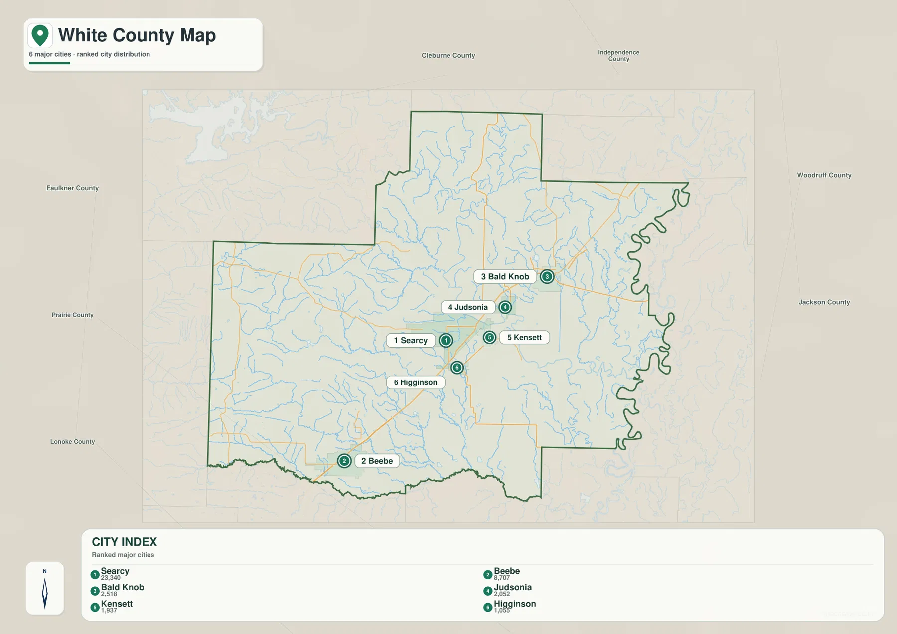
The population values printed in the supplied graphic are best treated as comparison figures within the image rather than current Census estimates. The map is most useful for showing the relative prominence and location of the communities. For current population or demographic data, use an official statistical source rather than relying on a static map label.
The Little Red River crosses the Searcy area on its way to the White River
The Little Red River is one of White County’s defining waterways. The Encyclopedia of Arkansas describes the river as flowing through north-central Arkansas, passing Searcy, and joining the White River near Georgetown in White County. USGS also maintains monitoring locations on the Little Red River around Searcy and Judsonia, confirming its importance in the central and eastern part of the county.
On the terrain-and-water map, the Little Red River enters from the higher northwestern side and turns through the central portion of the county before continuing toward the low eastern plain. Bayou Des Arc is a strong western water feature, while Cane Creek crosses the central-western area and Bull Creek follows a lower southern corridor. Numerous unnamed tributaries descend from the broken western terrain toward these larger channels.
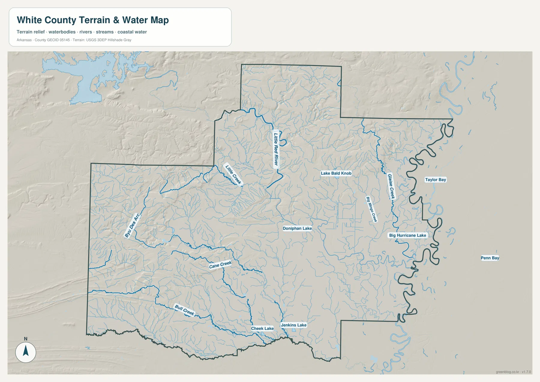
Several named lakes and creeks help organize the flatter eastern half. Doniphan Lake lies near the middle of the county, and Lake Bald Knob is farther northeast. Big Mingo Creek and Glase Creek run through the eastern interior, with Big Hurricane Lake close to the meandering county boundary. Taylor Bay and Penn Bay appear outside the boundary in the surrounding lowland context.
This is a county-scale geographic water reference. It does not replace flood-hazard maps, parcel surveys, water-quality information, or navigation guidance. If a decision depends on current risk, legal boundaries, or safe water access, consult the responsible agency’s specialized and up-to-date data.
The western uplands stand well above the White River lowlands
The elevation map shows an actual White County range of about 27 to 269 meters, with a mean near 103 meters. The strongest brown and tan relief is concentrated in the west and northwest, with another high area extending through the northern projection. Moving east from Searcy, the colors become progressively greener and broader low surfaces dominate the landscape.
The Encyclopedia of Arkansas describes White County as a small-scale version of Arkansas’s larger geographic contrast: the eastern half is alluvial land, while the western half is rocky higher ground. The supplied elevation map makes that difference easy to see. Rose Bud and the western uplands are close to some of the county’s highest relief, while the eastern side near the White River is broad and low.
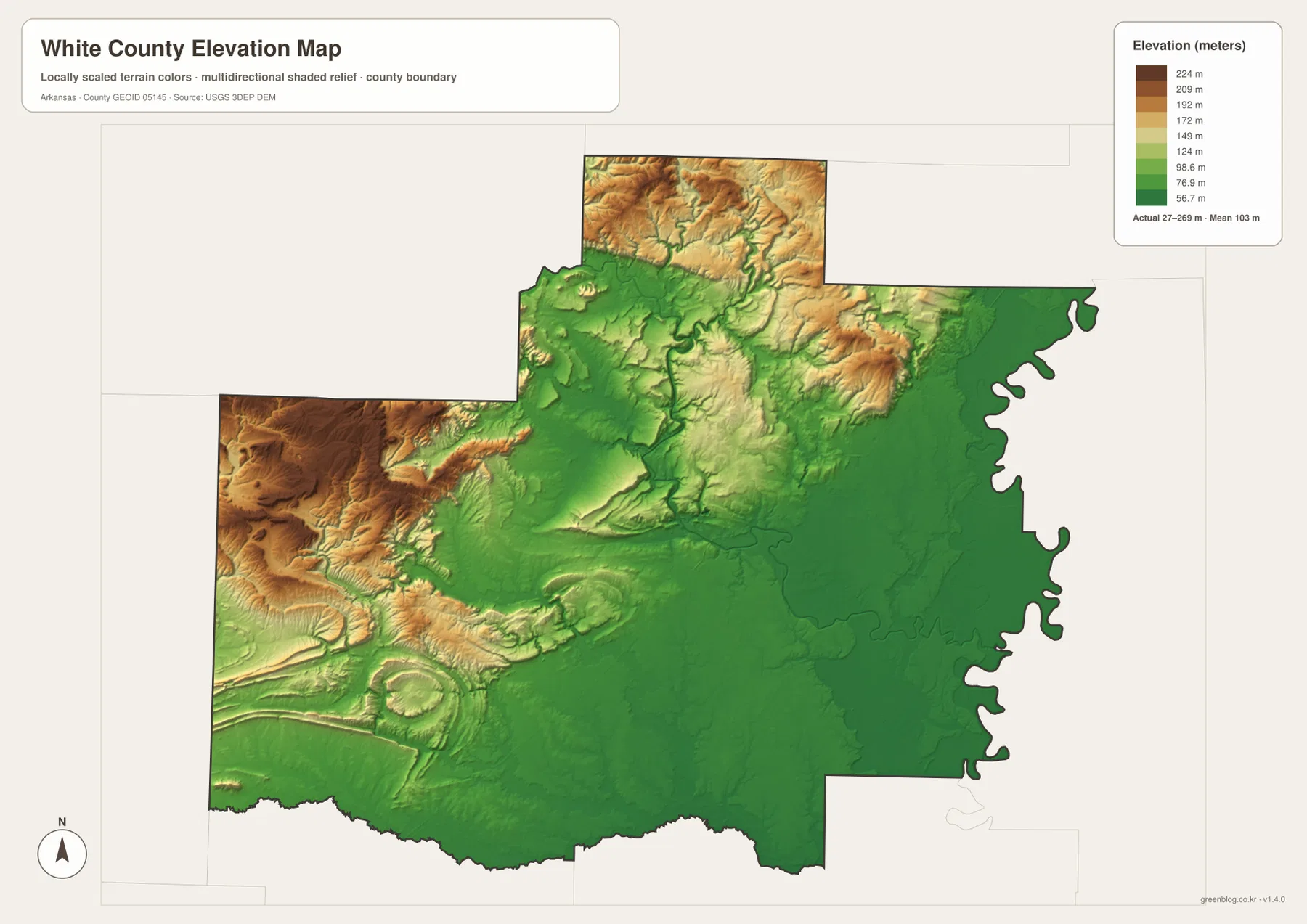
Bald Knob stands out as a separate area of higher relief within the generally low eastern half. The Little Red River corridor also appears as a lower green route through central and eastern White County. A USGS study of the lower Little Red River describes the downstream area near Judsonia and eastward toward the White River as flat terrain, which is consistent with the elevation pattern visible here.
The elevation colors are intended for broad terrain comparison, not property-level measurements. They are useful for understanding where White County is higher or lower, but should not be used for construction, drainage design, parcel elevations, or exact slope calculations. Detailed USGS 3D Elevation Program data or professional measurements are appropriate when precision is required.
Searcy and the Little Red River make the east–west transition easy to follow
A practical way to read the county is to locate Searcy first, then follow the settlement pattern north toward Judsonia and Bald Knob. These communities sit near the major central-to-northeast transportation corridor. Moving southwest from Searcy brings Beebe into view, while Rose Bud and Pangburn lead toward the less densely settled western uplands.
Next, switch to the water map and trace the Little Red River through the Searcy area toward the east. The elevation map shows the same path dropping into broad low terrain. West of the river corridor, short streams and ridges become more pronounced; east of Searcy, the surface becomes flatter and the meandering White River boundary dominates the edge of the county.
Neighboring county labels provide additional context. Faulkner and Lonoke counties are to the southwest and south, Prairie County is west of the lower county, Cleburne County is north, Independence and Jackson counties are toward the northeast and east, and Woodruff County appears beyond the eastern side in the supplied map context. Use the dark White County boundary to distinguish these outside labels from places inside the county.
Choose the file according to whether you need places, water, or terrain
The county reference map is the best starting point for Searcy, roads, railways, nearby counties, and smaller communities. The ranked city view is cleaner when you only need to compare Searcy, Beebe, Bald Knob, Judsonia, Kensett, and Higginson. The terrain-and-water map is better for the Little Red River and the many creeks and lakes, while the elevation map clearly shows the transition from western uplands to the eastern river plain.
Two maps together can make the county’s geography much easier to explain. Pair the reference and water views for Searcy and Judsonia to show their relationship with the Little Red River. Pair the reference and elevation views for Rose Bud and the western county to show how quickly relief increases. Bald Knob is another useful example because it appears as a local high point within the otherwise lower eastern half.
Each downloadable JPG measures 3638 × 2572 pixels and is suitable for A3 landscape printing, zooming into labels, or placing a map in a report or classroom handout. Keep the original aspect ratio when resizing so roads, streams, and the county outline are not stretched. Printer margins vary, so a test print is useful before producing multiple copies.
Frequently Asked Questions
What is the county seat of White County, Arkansas?
Searcy is the county seat. It is the largest city shown on the reference map and the strongest road and service center in the county. Judsonia, Bald Knob, Kensett, Higginson, and Beebe can all be oriented from Searcy.
Where does the Little Red River go after passing Searcy?
The Little Red River continues east through White County and joins the White River near Georgetown. The terrain and elevation maps show the river moving from higher inland country into the broad low eastern plain.
Why is western White County higher than the eastern side?
The western half contains rocky uplands and rolling relief, while the eastern half is largely alluvial lowland associated with the White River and lower Little Red River. The supplied elevation map shows an overall range of about 27 to 269 meters and a strong drop toward the east.
Map File Information
The ZIP contains the original White County reference, city, terrain-and-water, and elevation maps as high-resolution JPG files.
- Included Files: County reference map, city map, terrain-and-water map, elevation map
- Printable Size: 3638 × 2572 pixels each
- File Type: Four high-resolution JPG files in one ZIP archive
Related Maps
Sources and References
- Encyclopedia of Arkansas – White County – County-specific background on Searcy and the contrast between eastern alluvial land and western higher ground.
- Encyclopedia of Arkansas – Little Red River – Background on the river’s course through Searcy and its confluence with the White River near Georgetown.
- USGS – Little Red River at Judsonia – Official White County monitoring-location information for the Little Red River.
- USGS 3D Elevation Program – Official elevation and terrain data information.
Green Map creates custom-edited map images using open geographic data sources such as geoBoundaries, Natural Earth, OpenStreetMap, and government open data.
These maps are edited visual materials, not raw data files, and are provided for education, documents, presentations, and graphic reference.