Cross County sits in eastern Arkansas where a narrow belt of hills rises above broad lowlands on both sides. Wynne, the county seat, is the easiest place to use as an anchor when reading the county: Parkin lies to the east, Cherry Valley to the north, and Hickory Ridge to the northwest. The maps on this page show those communities together with roads, waterways, county boundaries, and elevation. After reviewing them on screen, you can use the map file box below to download the same map set as high-resolution JPG files.
The feature that gives the county its strongest geographic identity is Crowley’s Ridge. It runs generally north to south through the middle of the county and stands above the flatter land to the east and west. That higher strip helps explain why the water map looks divided: the western side drains toward the L’Anguille River, while the eastern side is tied more closely to the St. Francis River system. Looking at the road, water, and elevation maps together makes that contrast much clearer than any one layer can show on its own.
Table of Contents
Start with Wynne and the county’s main road pattern
Cross County covers about 616 square miles, and the 2020 Census counted 16,833 residents. Most of the map is rural, so the named communities provide useful reference points. Wynne is near the south-central part of the county, Parkin is well to the east, Cherry Valley is in the northern part, and Hickory Ridge is near the northwest side. The base map also labels Vanndale and Fair Oaks, helping fill in the large spaces between the incorporated cities.
Roads converge most noticeably around Wynne. Route 64 runs east toward Parkin, while Route 1 extends north from Wynne toward Vanndale. In the northern part of the county, Route 42 links the general area of Hickory Ridge and Cherry Valley. Other numbered routes, including 163, 184, 306, 75, 284, 350, 193, 259, and 364, show how smaller communities and rural areas connect to the larger east-west and north-south lines.
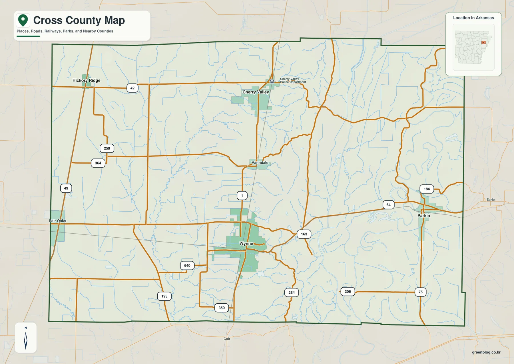
This map is most useful for orientation rather than turn-by-turn travel. It shows where a road crosses the county and which towns it serves, but it is not a live traffic or navigation product. If you are trying to understand why Parkin feels separated from the western part of the county, or how Cherry Valley relates to Wynne, begin with the road layout and then compare it with the elevation and water maps below.
Wynne as a hub: where Parkin, Cherry Valley, and Hickory Ridge sit
The city-connections map simplifies the county by using Wynne as the hub and marking three other incorporated cities. It places Parkin about 13 miles from Wynne, Cherry Valley about 11 miles away, and Hickory Ridge about 17 miles away. Those figures are direct straight-line distances, not driving distances. A road route can be longer because it follows the available highway network rather than a straight line across the map.
Direction is more informative than the numbers alone. Parkin is east of Wynne near the St. Francis River side of the county. Cherry Valley is north of Wynne and close to the higher Crowley’s Ridge belt, while Hickory Ridge is northwest in flatter country. Seeing those three directions at once makes it easier to understand why Wynne functions as the central reference point on the map even though it is not located at the geometric center of the county.
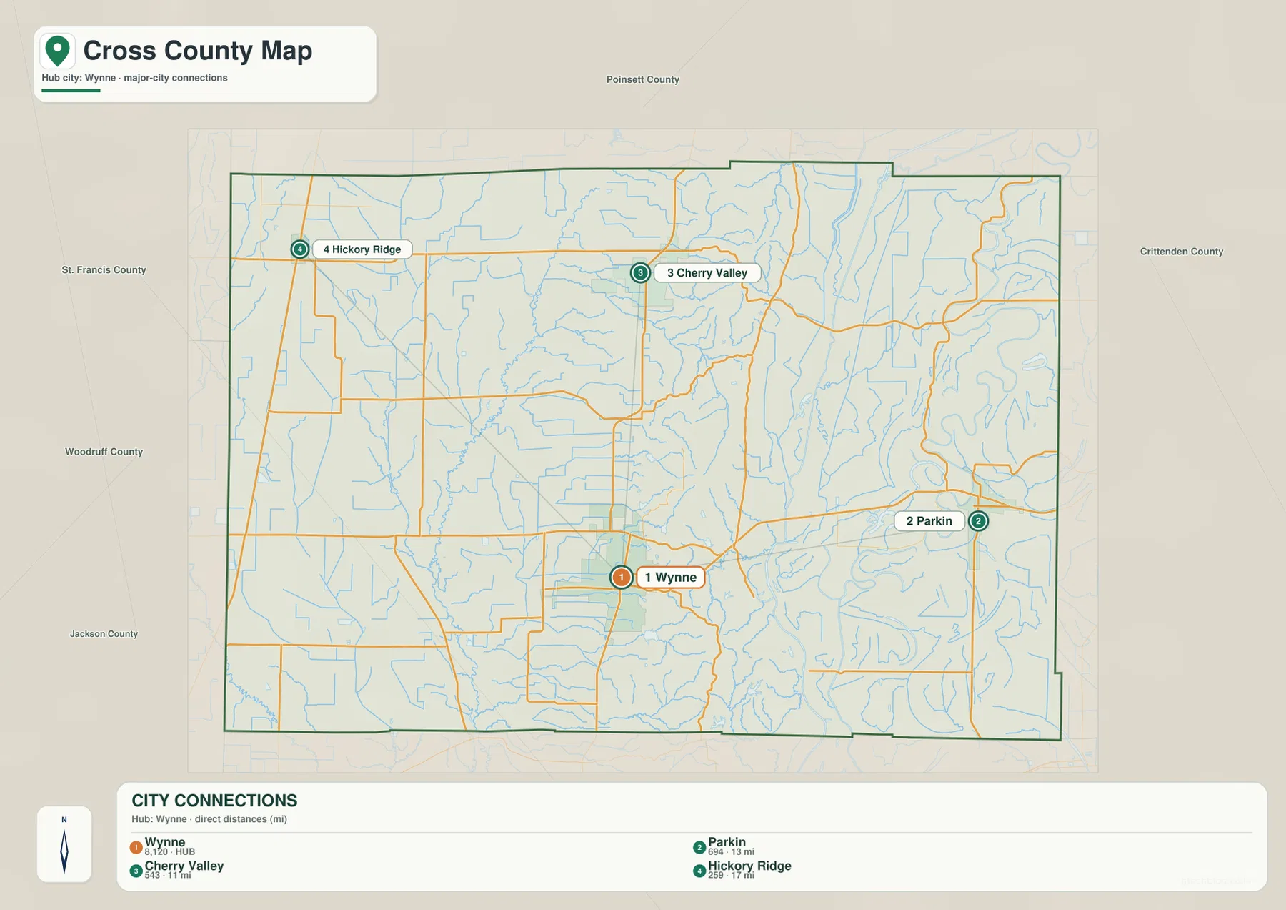
The official county website identifies Wynne as both the county seat and the largest town, with Cherry Valley, Hickory Ridge, and Parkin as the other incorporated cities. That makes the hub format a practical way to read the county without turning the article into a long list of small places. Vanndale and Fair Oaks still matter on the detailed map, but the four incorporated cities give a clear framework for understanding the settlement pattern.
A narrow high belt breaks up an otherwise low landscape
The elevation map changes the way Cross County looks. Instead of a mostly rectangular county filled with roads and streams, it reveals a long, irregular band of higher ground extending from north to south. This is Crowley’s Ridge. The local elevation scale on the map reports an actual range of roughly 52 to 142 meters, with a mean near 72 meters. The darkest browns follow the higher ridge areas, while much of the land to either side remains green at lower elevations.
The ridge is not a smooth wall. It widens and narrows, and many short valleys cut into its sides. In the north and south, finger-like spurs make the high ground look especially broken. The lowlands to the west are much more even, while the east side drops toward the St. Francis River floodplain. That sharp change over a relatively short distance is one of the most important visual clues for understanding the county.
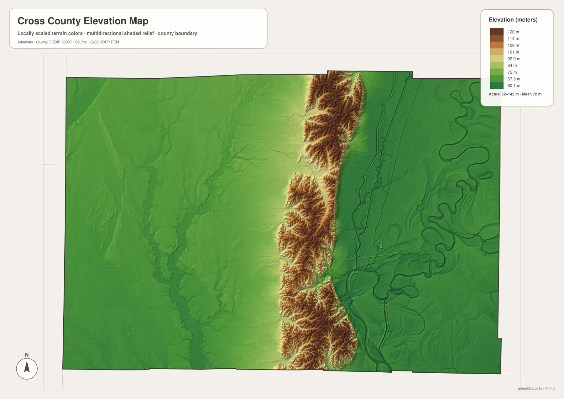
Regional sources describe Crowley’s Ridge as running through the county and rising above the alluvial plains on both sides. Wynne is closely associated with this higher ground, while Parkin lies in the lower eastern part of the county. The elevation map is therefore useful for comparing places, but it should not be treated as survey-grade data. It is a generalized terrain surface intended to show county-scale relief, not the exact elevation of a building lot, bridge, levee, or engineering site.
Waterways split toward the L’Anguille and St. Francis systems
The water and terrain map makes the ridge’s role even easier to see. On the western side, the L’Anguille River forms the strongest north-south water line, joined by features such as the Black Fork L’Anguille River, Prairie Creek, Morgan Creek, and Lick Creek. On the eastern side, the St. Francis River and Saint Francis Bay dominate the lowland drainage, with the Tyronza River, Old River, Rainbow Lake, and Grassy Lake Cutoff also labeled.
These are not two identical river landscapes. The L’Anguille side shows a comparatively clear southward trunk river with smaller channels feeding it. The eastern side contains broader, more sinuous channels and old river features associated with the St. Francis lowland. Between them, the ridge carries many short streams off its slopes but keeps the two main drainage directions visually distinct.
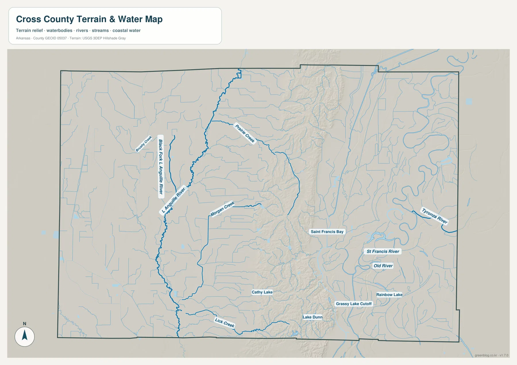
Several smaller water bodies are useful landmarks as well. Cathy Lake and Lake Dunn appear in the southern half, while Rainbow Lake is labeled farther east. These labels help with geographic context, but the map is not a flood-risk map, navigation chart, parcel map, or legal water-boundary product. For current water levels, flood conditions, or boating information, consult the appropriate federal or state service.
Why Wynne developed at a useful crossing point
The present road map reflects a much older transportation story. The Encyclopedia of Arkansas notes that railroad development was central to Wynne’s growth in the late nineteenth century. A north-south railroad reached the area first, followed by an east-west line that used a natural gap in Crowley’s Ridge near Wynne. The town became an important junction and later, in 1903, the county seat.
You do not need the historical rail lines to use the maps, but the background explains why Wynne became the logical hub for this page. The county’s central high ground could be an obstacle to east-west movement, yet a lower passage through the ridge offered a workable crossing. When the base map and elevation map are viewed side by side, the concentration of routes around Wynne makes more geographic sense.
Parkin marks the low eastern side beside the St. Francis River
Parkin provides a strong contrast with Wynne and the ridge. It lies near the eastern edge of the county along the Route 64 corridor and close to the St. Francis River system. On the elevation map, this side is mostly low and green rather than brown and dissected. On the water map, large winding channels are much more prominent. The city-connections map places Parkin about 13 straight-line miles east of Wynne, making it a convenient reference point for the county’s east-west change in terrain.
The town also has a direct connection to the river’s history. Parkin Archeological State Park preserves a Mississippian-period Native American village site on the St. Francis River. The park is a National Historic Landmark and includes evidence from centuries of occupation. The maps here are not visitor maps for the park, but knowing that this important site sits beside the river helps explain why the Parkin area is more than simply the eastern endpoint of a road line.
Cherry Valley and Hickory Ridge show two different northern settings
Cherry Valley and Hickory Ridge are both north of Wynne, yet they occupy different parts of the county’s terrain. Cherry Valley is much closer to the northern section of Crowley’s Ridge. Small streams cut through the nearby higher ground, and the elevation map shows a broken belt of hills in that part of the county. Hickory Ridge, farther northwest, sits in a lower and more even landscape away from the main ridge.
Route 42 gives the northern part of the base map a clear east-west reference, while the city map shows Cherry Valley about 11 straight-line miles from Wynne and Hickory Ridge about 17 miles away. The contrast is useful when describing Cross County because it prevents the whole northern area from being treated as one uniform landscape. One community is closely tied to the ridge, while the other is more closely associated with the flatter western side.
How to choose the most useful Cross County map for your task
Use the base map first when you need names, boundaries, and roads in the same view. It is the best choice for locating Wynne, Parkin, Cherry Valley, Hickory Ridge, Vanndale, and Fair Oaks before moving to a more specialized layer. The city-connections map is better when the question is simply where the incorporated cities sit in relation to Wynne and how far apart they are in a direct line.
For physical geography, compare the water and elevation maps. The water map shows why the western L’Anguille system and eastern St. Francis system feel like separate sides of the county. The elevation map supplies the missing reason: Crowley’s Ridge rises between them. Reading those two together is especially useful for students, local-history readers, and anyone trying to understand the county beyond its highway network.
The on-page WebP images are sized for convenient viewing, while the downloadable JPG files are 3638 by 2572 pixels each. That higher resolution is helpful for printing, presentations, classroom material, or a larger computer display. For legal boundaries, engineering, flood decisions, property work, or current navigation, use the relevant government source instead of relying on these reference maps alone.
Frequently Asked Questions
Are the distances from Wynne to Parkin, Cherry Valley, and Hickory Ridge driving distances?
No. The city-connections map uses direct straight-line distances. It shows Parkin at about 13 miles, Cherry Valley at about 11 miles, and Hickory Ridge at about 17 miles from Wynne. Actual driving mileage can be longer because roads do not follow a perfectly straight line.
Where is Crowley’s Ridge most obvious on the Cross County maps?
The elevation map shows it most clearly as the brown and tan high ground running north to south through the county. Compare that band with the lower green plains toward the L’Anguille River on the west and the St. Francis River on the east. The base map then helps place Wynne and Cherry Valley in relation to the ridge.
Can the water map be used for flood risk or navigation?
No. It is a geographic reference showing rivers, creeks, lakes, and related water features. It does not provide live water levels, flood-zone boundaries, navigation depths, or legal property information. Check current USGS, weather, emergency-management, or state sources for those purposes.
Map File Information
The download includes the Cross County base map, city-connections map, terrain and water map, and elevation map as high-resolution JPG files. Review the WebP maps on the page first, then save the ZIP when you need the larger originals.
- Included Files: Use only the versions confirmed in the article and supplied images
- File Type: Use the confirmed download contents
- Intended Use: Printing, education, presentations, and map-based projects
Related Maps
Sources and references
- Cross County, Arkansas official website – county seat, incorporated cities, and local overview
- Encyclopedia of Arkansas – Cross County – Crowley’s Ridge, drainage, history, and county background
- U.S. Census Bureau TIGER/Line Shapefiles – boundary, road, and geographic reference data
- USGS National Hydrography – rivers, streams, and water features
- USGS 3D Elevation Program – elevation and terrain data
- Arkansas State Parks – Parkin Archeological State Park – county-specific history beside the St. Francis River
Green Map creates custom-edited map images using open geographic data sources such as geoBoundaries, Natural Earth, OpenStreetMap, and government open data.
These maps are edited visual materials, not raw data files, and are provided for education, documents, presentations, and graphic reference.