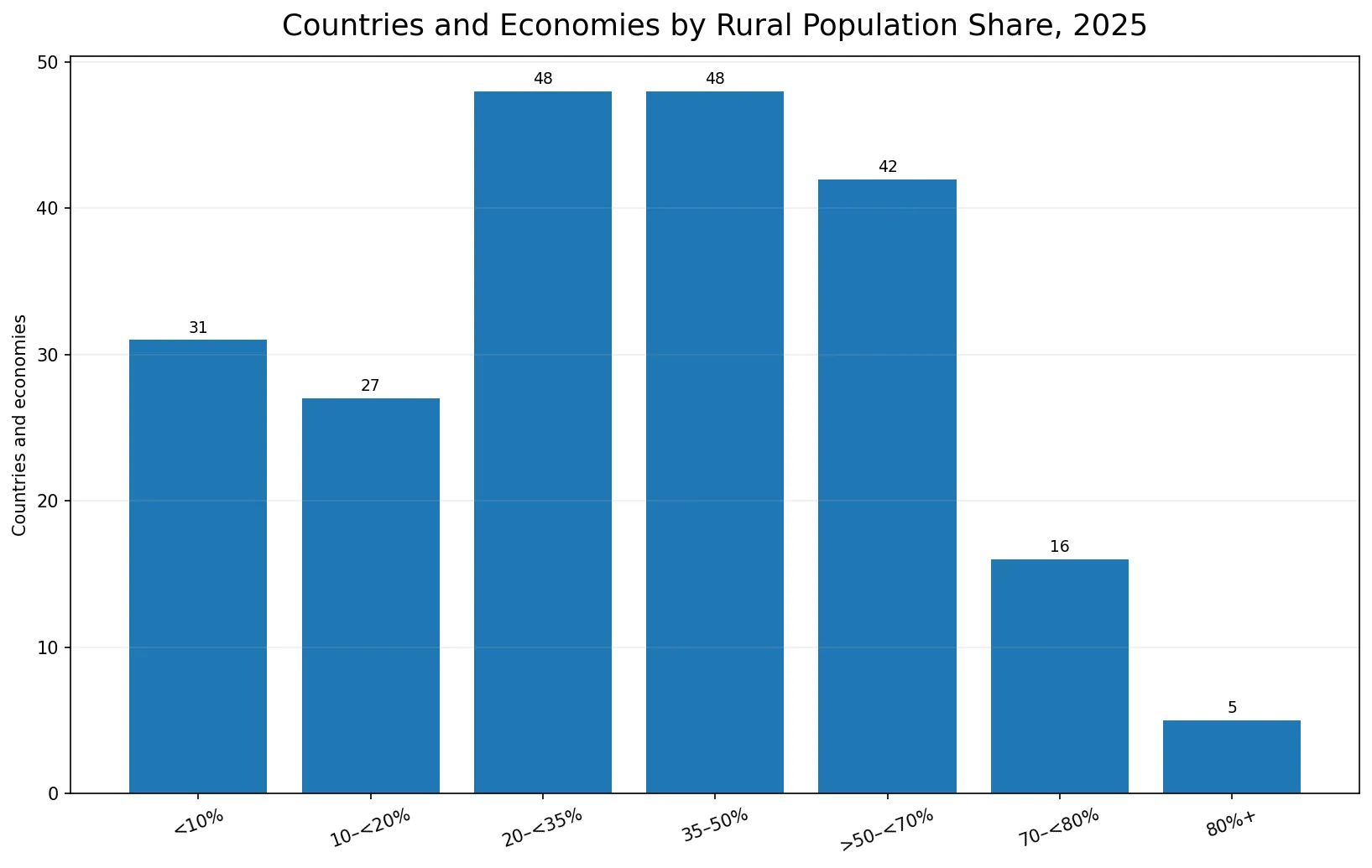
In 63 of the 217 reported 2025 country and economy observations, more than half of the population is classified as rural. 21 observations are at 70% or above and 5 reach 80% or more. At the other end, 58 observations are below 20% rural.
The World Bank indicator is SP.RUR.TOTL.ZS, formally titled Rural population (% of total population). It measures the share of people living in areas classified as rural by national statistical offices. The World Bank methodology calculates the rural share as 100 minus the urban population share.
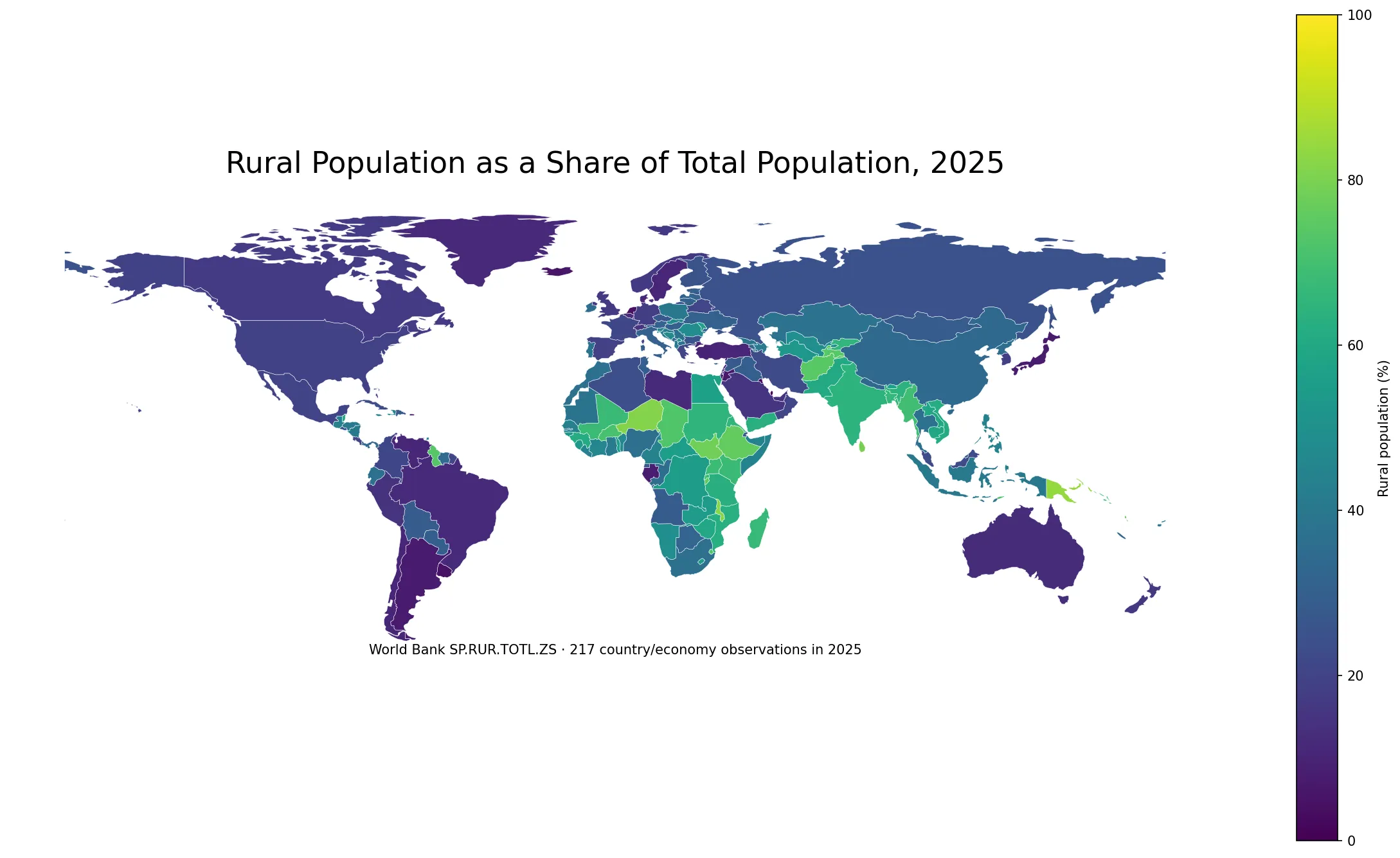
Table of Contents
Rural residents outnumber urban residents in 63 observations
The median rural share is 35.8% and the unweighted mean is 36.9%. The middle half of the observations lies roughly between 19.5% and 55.5%. These are distribution statistics across country/economy rows, not a population-weighted global rural share.
Liechtenstein, Papua New Guinea, Samoa, Malawi and Niger exceed 80%
Liechtenstein is highest at 85.4%, followed by Papua New Guinea at 84.2%, Samoa at 82.5%, Malawi at 82.4%, and Niger at 81.6%. Sri Lanka, Tonga, South Sudan, Vanuatu and the Federated States of Micronesia are also close to or above the upper 70s.
| Country or economy | Rural population share, 2025 |
|---|---|
| Liechtenstein | 85.4% |
| Papua New Guinea | 84.2% |
| Samoa | 82.5% |
| Malawi | 82.4% |
| Niger | 81.6% |
| Sri Lanka | 79.5% |
| Tonga | 78.8% |
| South Sudan | 78.3% |
| Vanuatu | 77.7% |
| Micronesia, Fed. Sts. | 77.5% |
This ranking should not be renamed a ranking of agricultural economies, rural land area or settlement density. The indicator classifies people, using national urban-rural definitions, rather than measuring the physical area of rural land.
31 observations are below 10%, including 12 at 0%
Bermuda, Bahrain, the Cayman Islands, Hong Kong SAR, Kuwait, Macao SAR, Monaco and Singapore are among the observations recorded at 0% rural population in 2025. A zero does not mean every square kilometer is built-up land; it means the population is classified as entirely urban for this statistical indicator.
| Rural population share | Countries/economies | Share of 217 |
|---|---|---|
| <10% | 31 | 14.3% |
| 10–<20% | 27 | 12.4% |
| 20–<35% | 48 | 22.1% |
| 35–50% | 48 | 22.1% |
| >50–<70% | 42 | 19.4% |
| 70–<80% | 16 | 7.4% |
| 80%+ | 5 | 2.3% |
India, Bangladesh and Pakistan remain majority-rural, while China and Indonesia do not
Among large-population countries, Ethiopia is at 75.9%, Afghanistan 74.1%, Bangladesh 66.8%, India 64.3%, and Pakistan 60.5%. Indonesia is 40.6%, Nigeria 36.2%, and China 33.7%.
| Country | Rural population share, 2025 |
|---|---|
| Ethiopia | 75.9% |
| Afghanistan | 74.1% |
| Bangladesh | 66.8% |
| India | 64.3% |
| Pakistan | 60.5% |
| Indonesia | 40.6% |
| Nigeria | 36.2% |
| China | 33.7% |
| France | 21.2% |
| Mexico | 20.0% |
| United States | 19.8% |
| Korea, Rep. | 18.8% |
| Canada | 17.1% |
| Germany | 17.9% |
| Brazil | 11.8% |
| Australia | 12.3% |
| Japan | 7.7% |
Korea is at 18.8%, the United States 19.8%, Mexico 20.0%, Canada 17.1%, and Germany 17.9%. Brazil is 11.8%, Australia 12.3%, and Japan 7.7%. Similar percentages do not imply similar settlement systems or rural geography.
This indicator is the exact complement of the urban population share
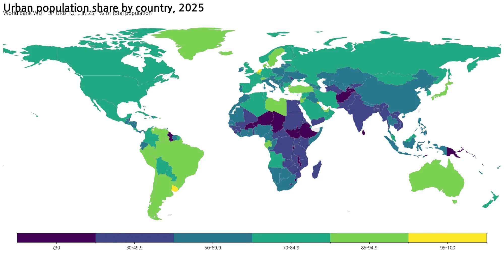
The World Bank metadata states that the rural percentage is calculated as 100 minus the urban population percentage. SP.RUR.TOTL.ZS and SP.URB.TOTL.IN.ZS therefore describe the same classification from opposite sides. They should not be treated as two independent variables.
The purpose of this article is therefore not to reproduce the urbanization ranking in reverse. It focuses on the threshold question of where rural residents still form the majority and on how the level indicator differs from rural population growth.
Rural population share and rural population growth answer different questions
A high rural share does not mean the rural population is currently growing quickly. The share measures how much of the total population is rural at one point in time, while the rural population growth rate measures annual change in the rural population itself. A country can have a high rural share and a declining rural population, or a low rural share and a growing rural population.
Total population growth is another separate measure. Births, deaths and international migration change the national total, while migration and statistical classification can also affect the urban-rural distribution. Those mechanisms require additional indicators rather than inference from the rural share alone.
National definitions limit precise cross-country ranking
The World Bank notes that countries do not use one universal definition of urban and rural areas. Definitions can depend on settlement size or characteristics, infrastructure and services, or administrative designation. That makes broad differences more informative than very small rank gaps.
The map is therefore strongest for identifying large contrasts, such as below 20% versus above 70%, and for seeing where the rural population still exceeds half of the national total. It is not a universal score of how rural a country’s physical landscape looks.
Data source and mapping method
The statistical source is World Bank WDI SP.RUR.TOTL.ZS. All 217 retained observations are dated 2025 after aggregate regional and income-group rows are excluded. The median (35.81%), simple mean (36.87%), quartiles and threshold counts are calculated directly from those rows.
ISO-3 codes are joined to a simplified world boundary layer for the map. The statistical sample contains 217 observations, while 171 low-resolution polygons are directly matched to values. Small islands and separately reported territories can remain in the statistics without a distinct visible polygon at world scale.
Frequently Asked Questions
What does rural population share measure?
It is the percentage of the total population living in areas classified as rural under national statistical definitions. The World Bank indicator code is SP.RUR.TOTL.ZS.
How many 2025 observations are majority-rural?
Among the 217 same-year observations, 63 have rural population shares above 50%.
Is rural population share independent from the urbanization rate?
No. The World Bank calculates the rural share as 100 minus the urban population share, so the two indicators are complements of the same classification.
Does a high rural share mean the rural population is growing?
Not necessarily. Rural share is a one-year population composition measure, while rural population growth measures annual change in the rural population itself.
Related Articles
These related articles separate the rural share from rural population change, urban share and total population growth.
- Global Rural Population Growth Map – Country Changes in 2025
- Global Urbanization Rate Map – Urban Population by Country in 2025
- Global Population Growth Map – Country Patterns in 2025
Green Map creates custom-edited map images using open geographic data sources such as geoBoundaries, Natural Earth, OpenStreetMap, and government open data.
These maps are edited visual materials, not raw data files, and are provided for education, documents, presentations, and graphic reference.