Dallas County sits in southern Arkansas, where small towns are spread across a broad rural landscape rather than clustered around one central urban area. Fordyce, the county seat, lies close to the southeastern edge, while Princeton is near the middle of the county, Sparkman is to the west, and Carthage is farther north. The maps on this page show those places together with major roads, county boundaries, creeks, lakes, and elevation. High-resolution JPG versions of the same maps are also available in the download box near the end of the page.
The county becomes much easier to understand when the road map, water map, and elevation map are viewed together. Northern and north-central Dallas County contain long ridges and broken uplands, while lower ground spreads across much of the southwest and along creek valleys. Cypress Creek is prominent on the western side, and the Tulip Creek system crosses the central part of the county. Fordyce occupies a different setting near the southeast, where several highways meet and the terrain is generally lower than the strongest ridges to the north.
Table of Contents
Dallas County from Fordyce to the northern boundary
Dallas County covers about 667 square miles according to the 2020 Census figures summarized by the Encyclopedia of Arkansas. Grant and Hot Spring counties are to the north, Cleveland County is to the east, Calhoun County borders the south, and Ouachita and Clark counties lie to the west and northwest. The county outline is not a simple rectangle. Its western and eastern sides include several bends and irregular sections, which makes the boundary useful as a visual reference when comparing the positions of the towns.
Fordyce is the present county seat and the largest city shown on the map. It is positioned near the southeastern edge instead of near the geographic center. Highways 79 and 167 meet there, a location also noted in the Encyclopedia of Arkansas entry for Fordyce. Other numbered routes visible around the city include 8, 229, 273, and 205. The concentration of roads makes Fordyce stand out immediately, while the rest of the county has longer stretches of road between smaller communities.
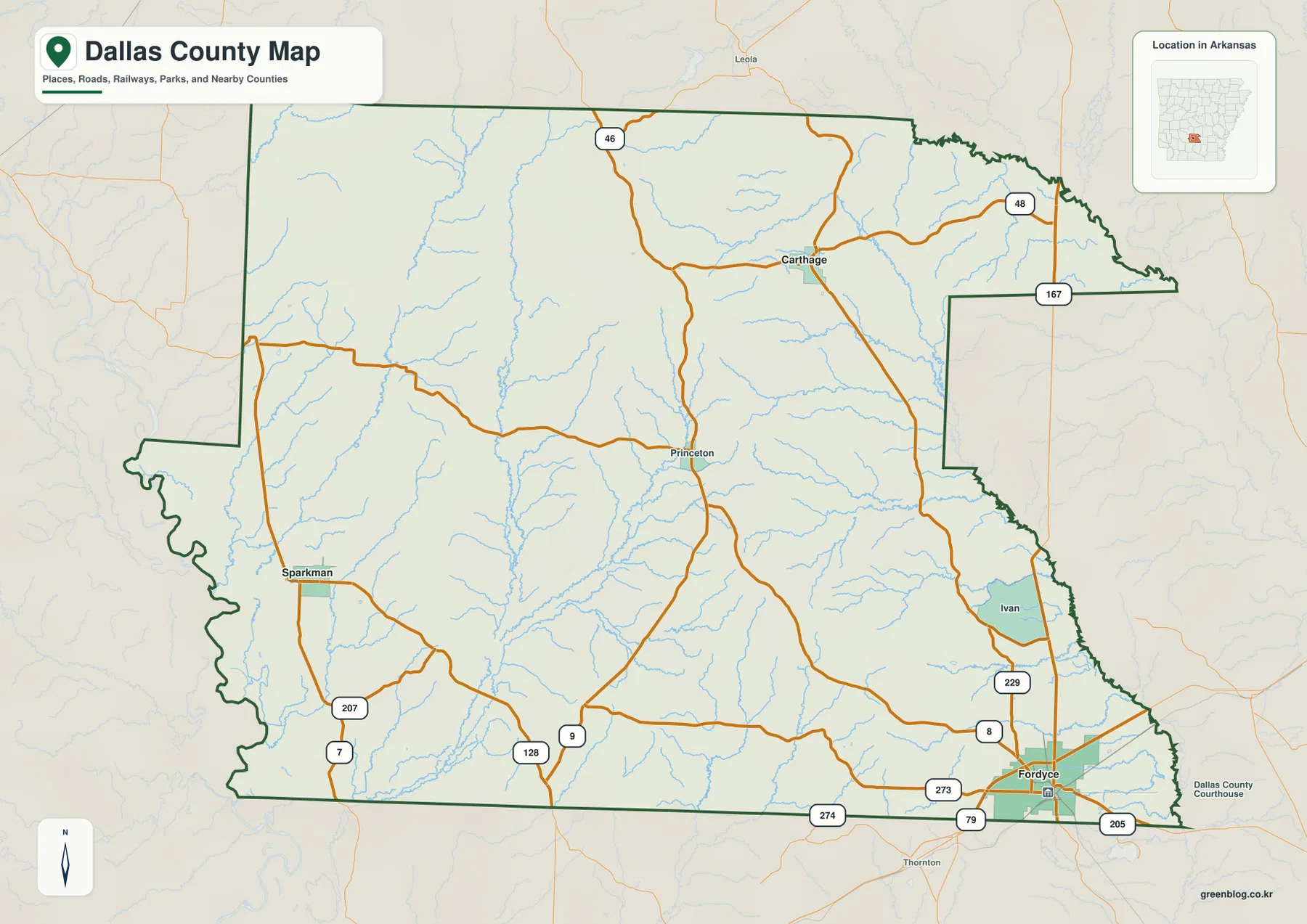
Princeton is a useful reference point near the middle of the county. From there, Fordyce lies to the southeast, Sparkman to the west, and Carthage to the north. Route numbers shown on the map include 46 and 48 in the north, 7 and 207 near Sparkman, and 9 and 128 in the south-central area. The map is designed to show relative location rather than turn-by-turn navigation, so current road conditions and driving routes should be checked with a modern navigation service when planning a trip.
How far Sparkman and Carthage sit from the Fordyce hub
The city-connections map uses Fordyce as the hub and highlights two other incorporated places: Sparkman and Carthage. The map gives a straight-line distance of about 26 miles from Fordyce to Sparkman and about 19 miles from Fordyce to Carthage. These are direct point-to-point measurements, not driving distances. Roads curve around terrain and do not always follow the shortest line, so the mileage on this map should not be used to estimate travel time.
The directions are just as useful as the numbers. Sparkman is well to the west-northwest of Fordyce, while Carthage is farther north. Princeton sits between these parts of the county on the main map even though it is not one of the emphasized comparison points on the city map. Because Fordyce is so close to the southeastern side of Dallas County, the county seat does not function as a visual center of the outline. A place can therefore be within the same county and still be a substantial distance from the administrative hub.
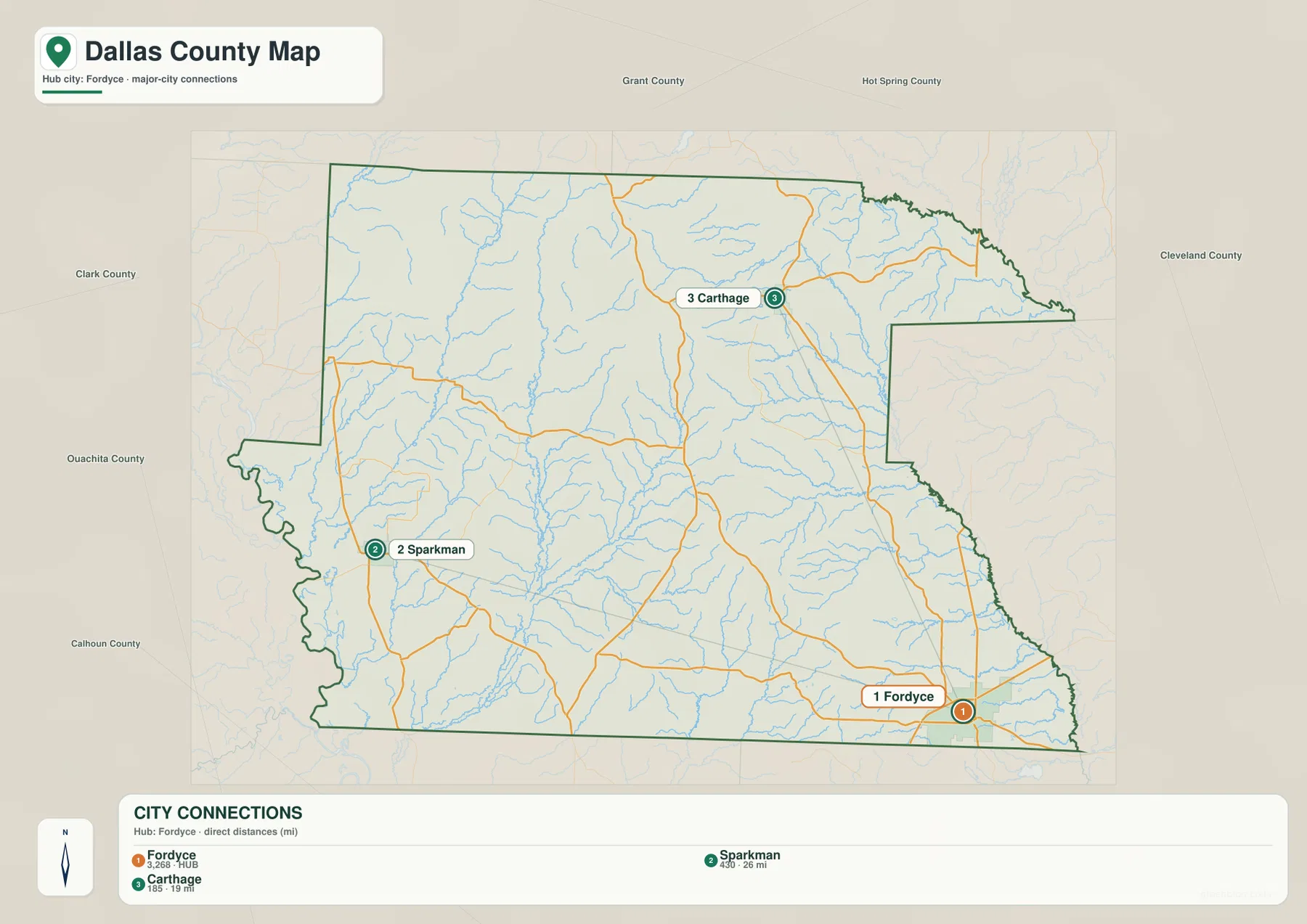
Neighboring county labels around the map help put those towns in context. Sparkman is relatively close to the Ouachita and Calhoun county sides of Dallas County, Carthage is nearer the Grant and Hot Spring county directions, and Fordyce is close to the Cleveland and Calhoun county sides. This arrangement matters when reading regional maps because each town faces a different edge of the county and different routes toward the surrounding communities.
Princeton marks an older center of Dallas County
Princeton is not the modern county seat, but its central location gives it special importance on the map. The Encyclopedia of Arkansas notes that Princeton served as the first county seat before Fordyce became the dominant town. On the present map, Princeton lies close to the middle of Dallas County, so it works well as an orientation point even for readers who know little about the county’s history. Roads extend from its vicinity toward Fordyce, Sparkman, Carthage, and the county boundaries in several directions.
Fordyce developed later in the southeastern part of the county as rail transportation and the timber industry expanded. That history helps explain why today’s administrative center is not in the middle of the county outline. The main map makes the contrast visible without needing a historic map: Princeton occupies a more central geographic position, while Fordyce has the stronger modern road concentration. Looking at both places prevents the county from being reduced to a single town and gives a better sense of how settlement and transportation changed over time.
Cypress Creek and the Tulip Creek branches across the interior
The terrain-and-water map shows a dense network of streams rather than one large river cutting through the center of Dallas County. Cypress Creek is one of the most prominent named waterways on the western side. In the central area, West Fork Tulip Creek and East Fork Tulip Creek join the larger Tulip Creek system, with White Oak Creek also labeled nearby. Moore Creek appears in the northeast, Coats Creek in the southeast, and Hall Creek is shown farther south. Long Lake and Shell Lake are marked near the southwestern portion of the county.
The map also places the Ouachita River just beyond the western side of the county, giving a useful regional reference for the western drainage. The smaller creeks inside Dallas County occupy valleys between ridges and rolling uplands. In the northwest, several narrow valleys run roughly north to south, while the central creek network bends through a more varied set of low corridors. These waterways are easier to understand when the water map is compared with the elevation map rather than viewed as isolated blue lines.
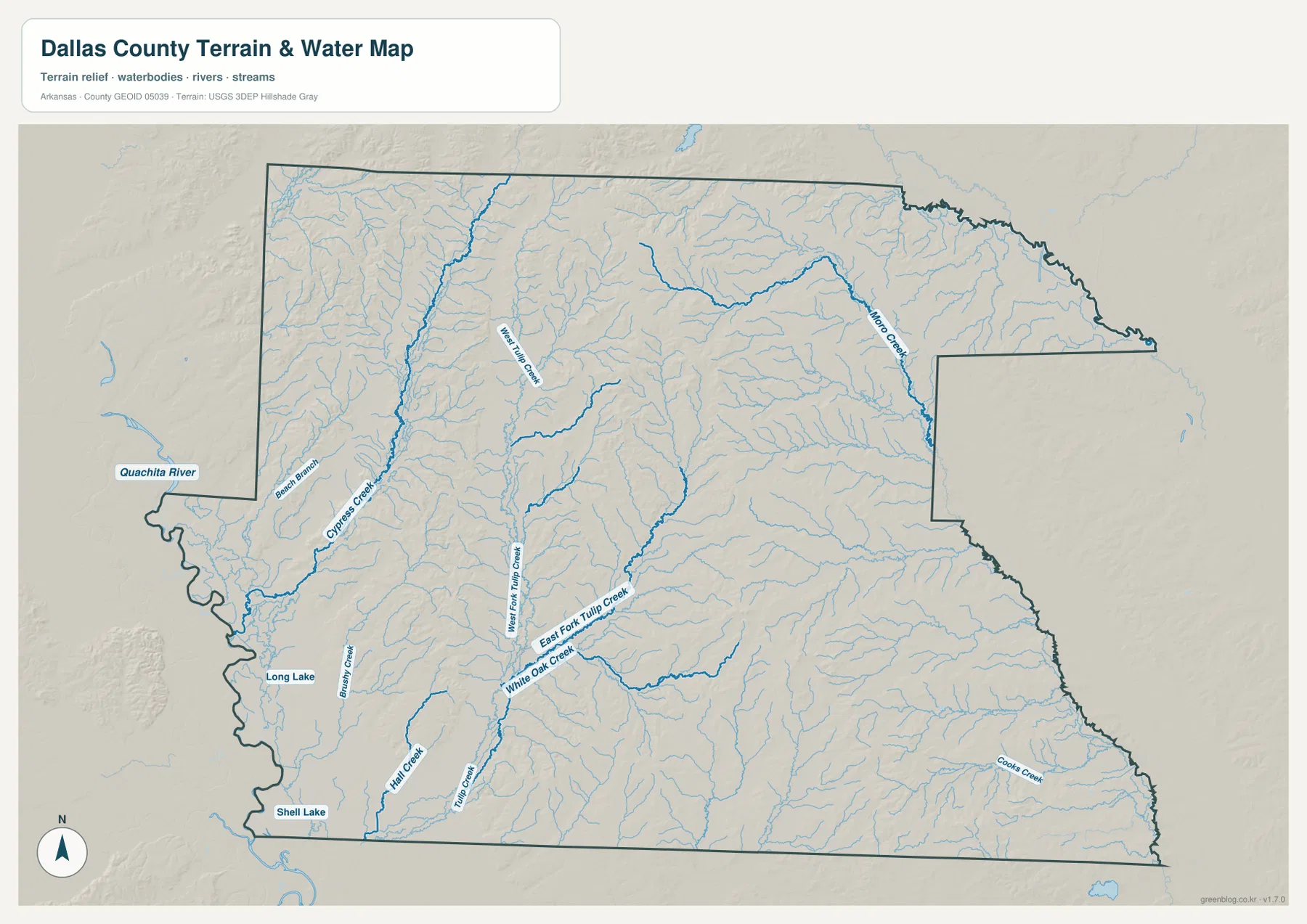
This water map is a geographic reference, not a flood or navigation product. It does not show live river levels, flood zones, legal water boundaries, safe boating routes, or property lines. The amount of detail shown for smaller streams can also vary with the source data and map scale. Anyone making a decision about flooding, water quality, stream management, or navigation should use the latest information from the appropriate government agency rather than relying on this general-purpose county map.
Northern ridges stand above the lower southwest
The elevation map makes the strongest physical contrast in Dallas County easy to see. The map reports an actual elevation range of roughly 33 to 152 meters, with a mean of about 82 meters. The highest brown and tan areas are concentrated in the northern and north-central parts of the county. Several elongated ridges are especially visible in the northwest, where higher ground alternates with narrow green valleys. The southwest, by contrast, contains a much broader area of lower elevation.
Central and southeastern Dallas County are not completely flat. Smaller ridges and knobs interrupt the lower green terrain, including several higher patches north and northwest of Fordyce. Around Princeton, creek valleys cut through rolling ground and create a clear pattern of low corridors between higher slopes. Near Sparkman, lower areas and gentle ridges alternate rather than forming the continuous high bands seen farther north. The visual difference between these areas is one of the best reasons to keep the elevation map separate from the road map.
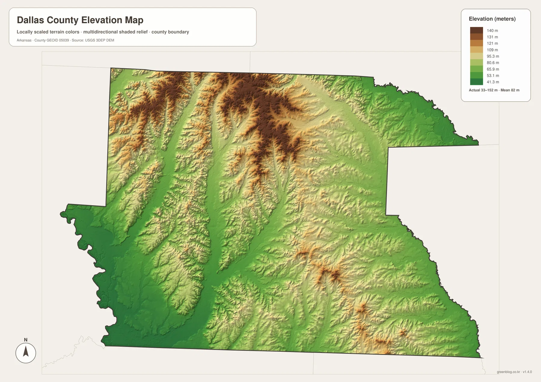
The shaded surface is meant for county-scale comparison, not engineering or survey work. It is useful for seeing which parts of Dallas County are relatively high or low and for matching creek valleys to surrounding ridges. It should not be treated as a precise elevation measurement for a house lot, road project, drainage design, or legal survey. For those tasks, the underlying USGS elevation products or a professional survey are more appropriate.
Why Fordyce has the county’s strongest road concentration
The road pattern around Fordyce reflects more than its current role as the county seat. According to the Encyclopedia of Arkansas, the town was established in the early 1880s along a railroad route and grew with rail transportation and the timber industry. Highways 79 and 167 still make Fordyce a clear junction on the modern county map. Other routes spread west, north, east, and south from the same part of the county, so Fordyce appears as a much denser road node than Princeton, Sparkman, or Carthage.
Sparkman presents a different pattern. It sits along Highway 7 on the western side, with roads extending through a much more lightly settled landscape. Carthage is tied to the northern road network, while Princeton remains centrally placed without having the same modern highway concentration as Fordyce. Those differences make the county map useful for more than locating city names: it also shows how four communities occupy distinct parts of a large rural county and connect to different surrounding counties.
Choosing the most useful map for Dallas County
Start with the main county map if you need to locate Fordyce, Princeton, Sparkman, Carthage, the county boundary, or the major numbered highways. It gives the broadest overview and makes it easy to see how far Fordyce sits from the geographic middle. The city-connections map is better when the main question is the direction and approximate straight-line separation between Fordyce, Sparkman, and Carthage. Remember that the distance labels are not road mileage.
For physical geography, the water and elevation maps work best as a pair. The water map identifies Cypress Creek, the Tulip Creek branches, Moore Creek, Coats Creek, Hall Creek, and several small lakes. The elevation map then shows the ridges and lower corridors around those streams. Comparing the two makes it easier to see why many waterways occupy narrow valleys and why northern Dallas County looks more broken and elevated than much of the southwest.
The WebP images embedded on the page are sized for quick viewing online. The downloadable JPG files are 3638×2572 pixels each, making them more suitable for larger displays, printed handouts, classroom material, or personal reference. These maps remain general reference products, however. Legal boundaries, parcel surveys, flood decisions, road construction, and other work that depends on current precision should be checked against the original Census, USGS, state, or professional data sources.
Frequently Asked Questions
Are the 26-mile and 19-mile labels from Fordyce driving distances?
No. The city-connections map uses straight-line distance. Sparkman is shown about 26 miles from Fordyce and Carthage about 19 miles away when measured directly between the mapped points. Actual driving distance can be longer because roads follow different routes, so use current navigation data for travel planning.
Where is the highest terrain in Dallas County?
The elevation map shows the strongest concentration of higher ground in northern and north-central Dallas County, including several long ridges in the northwest. Much of the southwest is lower, while smaller hills also appear around the central and southeastern parts of the county. The map lists an overall actual range of about 33 to 152 meters, but it is not a survey-grade elevation product.
Which map is best for finding Cypress Creek and the Tulip Creek branches?
Use the terrain-and-water map. It labels Cypress Creek on the western side and West Fork Tulip Creek, East Fork Tulip Creek, White Oak Creek, and Tulip Creek in the central part of the county. If you also want to compare those waterways with surrounding ridges and valleys, check the same locations on the elevation map.
Map File Information
The Dallas County package includes the main county map, city-connections map, terrain-and-water map, and elevation map as high-resolution JPG files. Review the maps on the page first, then use the ZIP when you need the larger originals.
- File Type: ZIP containing 4 JPG files
Related Maps
Sources and References
- Encyclopedia of Arkansas – Dallas County – county seat, area, history, and regional background
- Encyclopedia of Arkansas – Fordyce – Fordyce location, highways, railroad history, and timber-industry context
- U.S. Census Bureau TIGER/Line Shapefiles – county boundaries, roads, and other base map features
- USGS National Hydrography – rivers, streams, and water features
- USGS 3D Elevation Program – elevation and terrain data
Green Map creates custom-edited map images using open geographic data sources such as geoBoundaries, Natural Earth, OpenStreetMap, and government open data.
These maps are edited visual materials, not raw data files, and are provided for education, documents, presentations, and graphic reference.