This Jerauld County Map page includes a road-and-boundary map, a city-connections map, a terrain-and-water map, and an elevation map, with the original high-resolution JPG files available together in the download ZIP below. Wessington Springs is the easiest place to use as a reference point: Lane lies to the east, Alpena sits near the northeastern edge, and Spring Valley Colony appears farther west. The maps also show State Route 34 as the main east-west route through Wessington Springs, the north-south 281 corridor in the eastern part of the county, Firesteel Creek, the Smith Creek system, several named lakes, and a clear change from higher western terrain to lower ground in the east.
The four maps answer different practical questions without requiring the reader to treat them as a single image. The road map is best for locating towns and numbered routes. The simplified city map is useful when you only need the direction and straight-line distance from Wessington Springs to Lane or Alpena. The water map adds creek and lake names, while the elevation map makes the county’s 396–628 meter range easy to compare. Starting with the town locations and then moving to water and relief keeps the geography easy to follow.
Table of Contents
Roads and county position around Wessington Springs
On the road-and-boundary map, Wessington Springs sits slightly east of the county’s center and provides a natural starting point for orientation. Route 34 crosses the county from west to east through the Wessington Springs area and continues toward Lane. Farther east, 281 runs north-south, while 47 is labeled near the southeastern boundary. The smaller roads form a much denser local grid, so the numbered routes are the quickest way to establish direction before looking for individual place names.
Lane is easy to find because it lies east of Wessington Springs close to Route 34. Alpena is farther north and almost touches the northeastern edge of the county on the map. Spring Valley Colony is labeled in the western half, where there are fewer large place names and the road pattern is less visually dominant. Together, these labels show that the county’s settlements are not concentrated in one corner. They stretch from the western interior through Wessington Springs to the eastern boundary area.
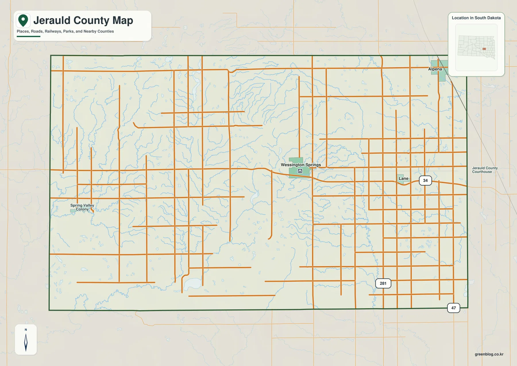
The map also provides context outside the county line by labeling neighboring county directions. That makes it useful for understanding where Jerauld County sits within central-eastern South Dakota before focusing on local roads. It should not be treated as a live traffic map, however. Construction, closures, winter conditions, and temporary detours can change after the map is produced, so current travel planning should use an up-to-date road service.
Lane and Alpena on the city-connections map
The city-connections map removes most of the small-road detail and focuses on three places: Wessington Springs, Lane, and Alpena. Wessington Springs is shown as the hub. Lane is almost directly east, while Alpena is northeast and close to the county boundary. Because only the major labeled places are shown, this version is useful when the main question is simply how the eastern towns relate to the county seat rather than which local road to take.
The distance labels are straight-line measurements, not driving mileage. Lane is shown about 7 miles from Wessington Springs, while Alpena is about 12 miles away. Actual road distance may be longer because travel follows the road network rather than a direct line between two points. These labels are therefore best used for quick relative comparison: Lane is the closer of the two, and Alpena lies farther away and more to the north.
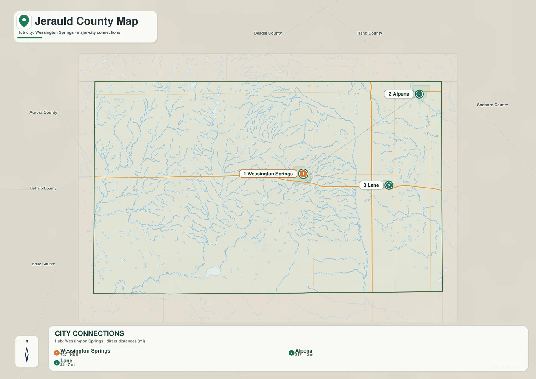
The numbered circles on the city map should not be read as a ranking of town size or importance. They are map labels that identify the places shown. For a road trip or driving-time estimate, return to the road map and then use a current routing service. For simple county orientation, the city-connections map is much faster because it makes the directions between the three towns immediately visible.
Firesteel Creek, Smith Creek, Sand Creek, and the named lakes
Water features create a different picture of Jerauld County. Firesteel Creek is the dominant named stream in the east, running roughly north-south near the lower eastern terrain. West Branch Firesteel Creek approaches from the west in the southern part of the county, while Sand Creek curves across the northeast. Dry Run Creek is labeled closer to the eastern edge. These features show that the eastern half is crossed by several distinct drainage lines rather than one continuous channel.
The southwestern part of the water map is organized around Smith Creek and East Fork Smith Creek. Crow Lake is labeled nearby, providing a clear landmark in the south. Farther north, Cottonwood Lake and Long Lake sit near one another, while Baker Lake and Deans Lake appear closer to the center. The map also contains numerous small unnamed tributaries, especially around the more uneven western terrain. Those shorter branches contrast with the longer named creek courses that stand out in the east.
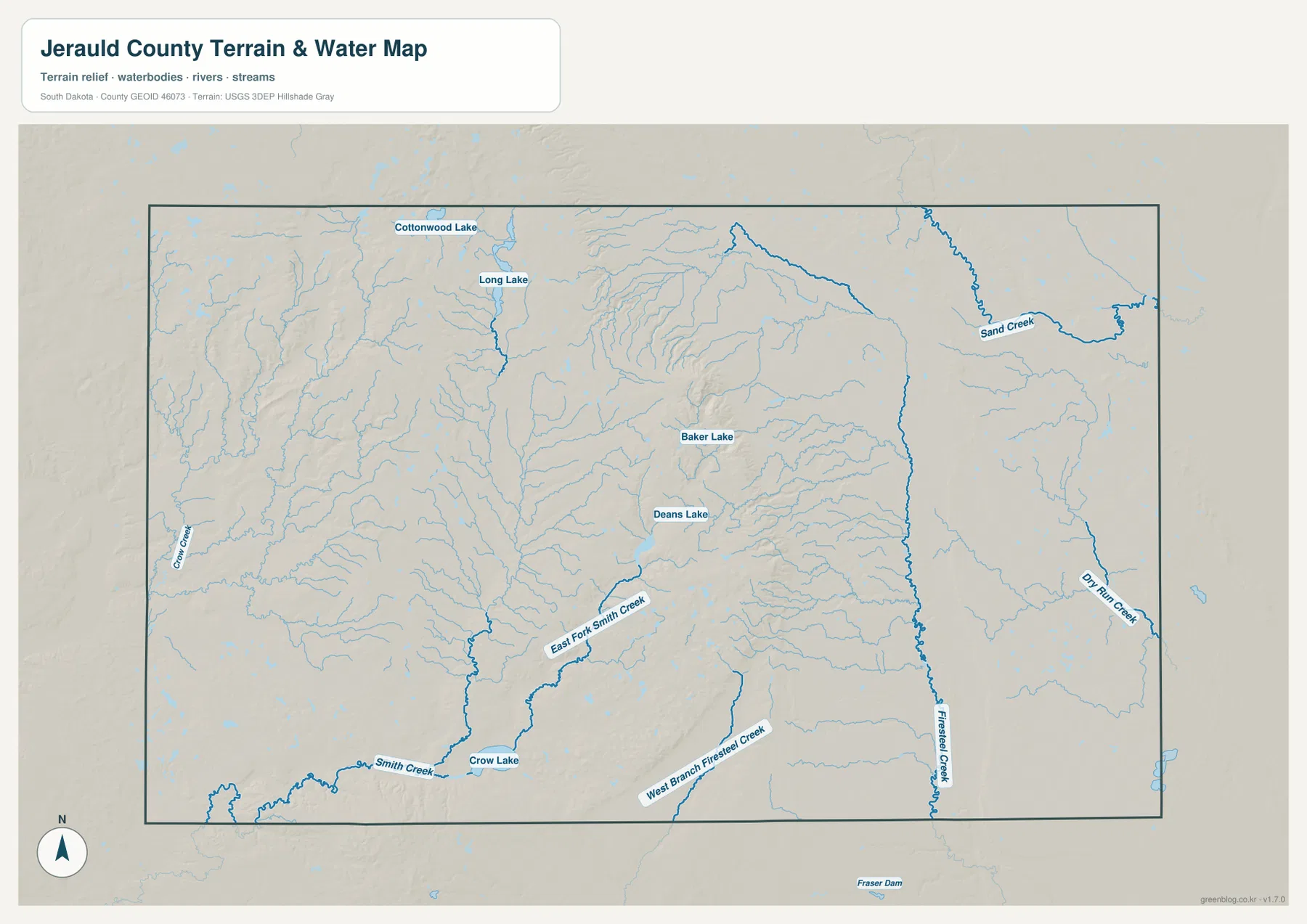
This is a geographic reference map, not a real-time hydrology product. A blue line does not guarantee the same amount of water at every season or on every date. Small tributaries may be simplified at this map scale, and some channels can look different after wet or dry weather. Flood risk, water depth, water quality, legal shoreline limits, and property boundaries require the official products created for those specific uses.
From western ridges to the lower eastern plain
The elevation legend gives Jerauld County an actual range of about 396 to 628 meters, with a mean near 500 meters. Brown and dark tan cover much of the west and northwest, marking the county’s higher terrain. Several ridges and steep-sided slopes are also visible in the west-central area. The eastern half is dominated by green, showing a broad area of lower and generally smoother ground.
The most noticeable transition occurs near the middle of the county, where higher brown terrain drops toward the green eastern plain. Wessington Springs lies close to this change. That makes it useful to compare the town’s location on the road map with the same area on the elevation map: higher ground rises to the west, while the route toward Lane continues across lower terrain to the east. Narrow valleys cut into the edge of the uplands and help explain why so many short tributaries appear on the water map.
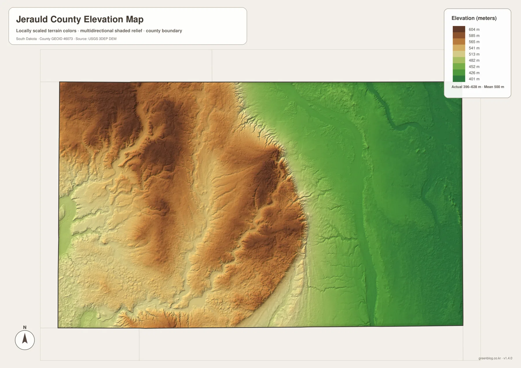
The elevation surface is intended for countywide comparison, not precise surveying. It can show whether one part of the county is generally higher or lower than another, but it does not provide a certified elevation for a lot, building corner, culvert, road point, or construction site. Engineering, construction, drainage design, and legal surveying should use the original elevation data and site-specific measurement.
Choosing the right map for a specific question
If you need to find Wessington Springs, Lane, Alpena, Spring Valley Colony, or the major numbered roads, begin with the road-and-boundary map. If your question is only how Lane and Alpena sit relative to Wessington Springs, the city-connections map removes distractions and gives the 7- and 12-mile straight-line labels. For Firesteel Creek, Smith Creek, Sand Creek, or the named lakes, use the terrain-and-water map first.
The elevation map becomes most useful after one or two place names are already familiar. Compare Wessington Springs with the western ridges, then trace east toward Lane and Firesteel Creek. You can also work in the opposite direction: start with the elevation colors, identify the lower eastern plain, and then use the water map to see which creeks occupy that part of the county. The maps complement one another because each one keeps a different type of information easy to see.
The WebP images in the article are resized for efficient browser viewing. For small road labels, creek names, terrain shading, A3 printing, presentations, classroom work, or personal reference, the original JPG files are more useful. The ZIP below contains the road-and-boundary map, city-connections map, terrain-and-water map, and elevation map as four 3638 × 2572 pixel JPG images.
Frequently Asked Questions
Are the 7- and 12-mile labels from Wessington Springs driving distances?
No. They are straight-line distances on the city-connections map. Lane is shown about 7 miles from Wessington Springs and Alpena about 12 miles away. Road distance can be longer because vehicles follow the road network, so use a current routing service when planning a drive.
Does the water map show whether Firesteel Creek or Smith Creek is flowing today?
No. The map shows the location of named streams, tributaries, and lakes. It does not provide real-time flow, seasonal water depth, flood stage, or water quality. Current hydrologic conditions should be checked with the appropriate official monitoring source.
Can the 396–628 meter range be used as the exact elevation of a property?
No. That range describes the broad elevation span across Jerauld County. The shaded map is suitable for comparing higher and lower parts of the county, but a parcel, building site, road point, or construction project requires original elevation data and site-specific surveying.
Map File Information
The ZIP contains the original Jerauld County road-and-boundary, city-connections, terrain-and-water, and elevation maps as high-resolution JPG files.
- Included Files: 4 high-resolution JPG maps
- Printable Size: 3638 × 2572 px each
Related Maps
Sources and references
- U.S. Census Bureau TIGER/Line Shapefiles – Official geographic reference data for county boundaries, roads, and place features.
- USGS National Hydrography – Official hydrography information for streams, rivers, lakes, and related water features.
- USGS 3D Elevation Program – Official USGS elevation and 3DEP information for terrain reference.
Green Map creates custom-edited map images using open geographic data sources such as geoBoundaries, Natural Earth, OpenStreetMap, and government open data.
These maps are edited visual materials, not raw data files, and are provided for education, documents, presentations, and graphic reference.