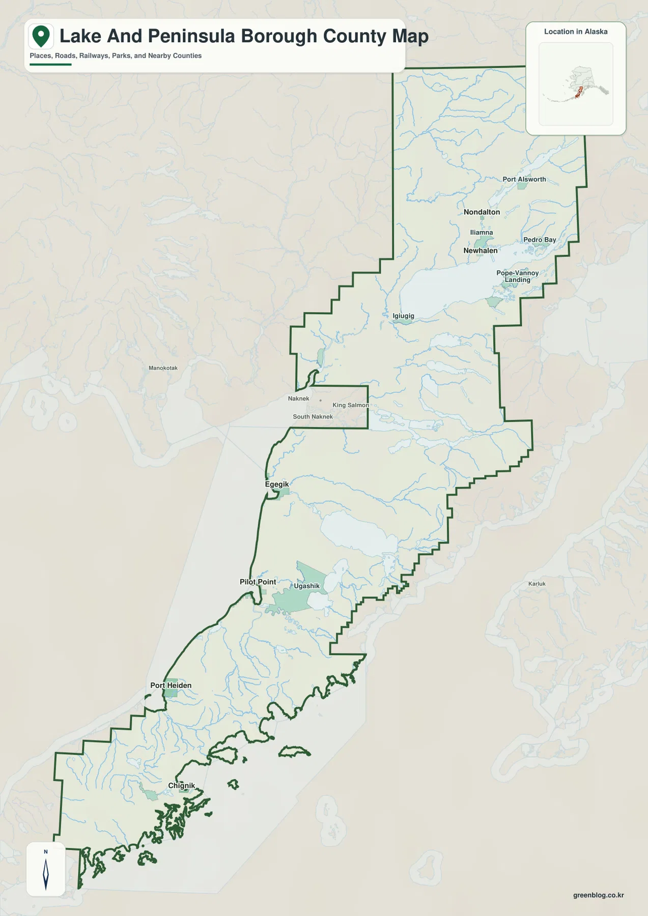
Lake and Peninsula Borough stretches across a long section of southwest Alaska where large inland lakes, river valleys, Bristol Bay shoreline, and a narrow southern peninsula all appear within one administrative outline. The supplied general map places Newhalen, Nondalton, Iliamna, and Port Alsworth in the broad northern part of the borough, then carries the eye south through Igiugig, Egegik, Pilot Point, Port Heiden, and Chignik. The communities are not arranged around a single road-connected center, so the map makes more sense when it is read as a sequence of northern lake country, Bristol Bay settlements, and a long southern coast. The same map subjects are available as larger JPG files in the download box below for printing and offline reference.
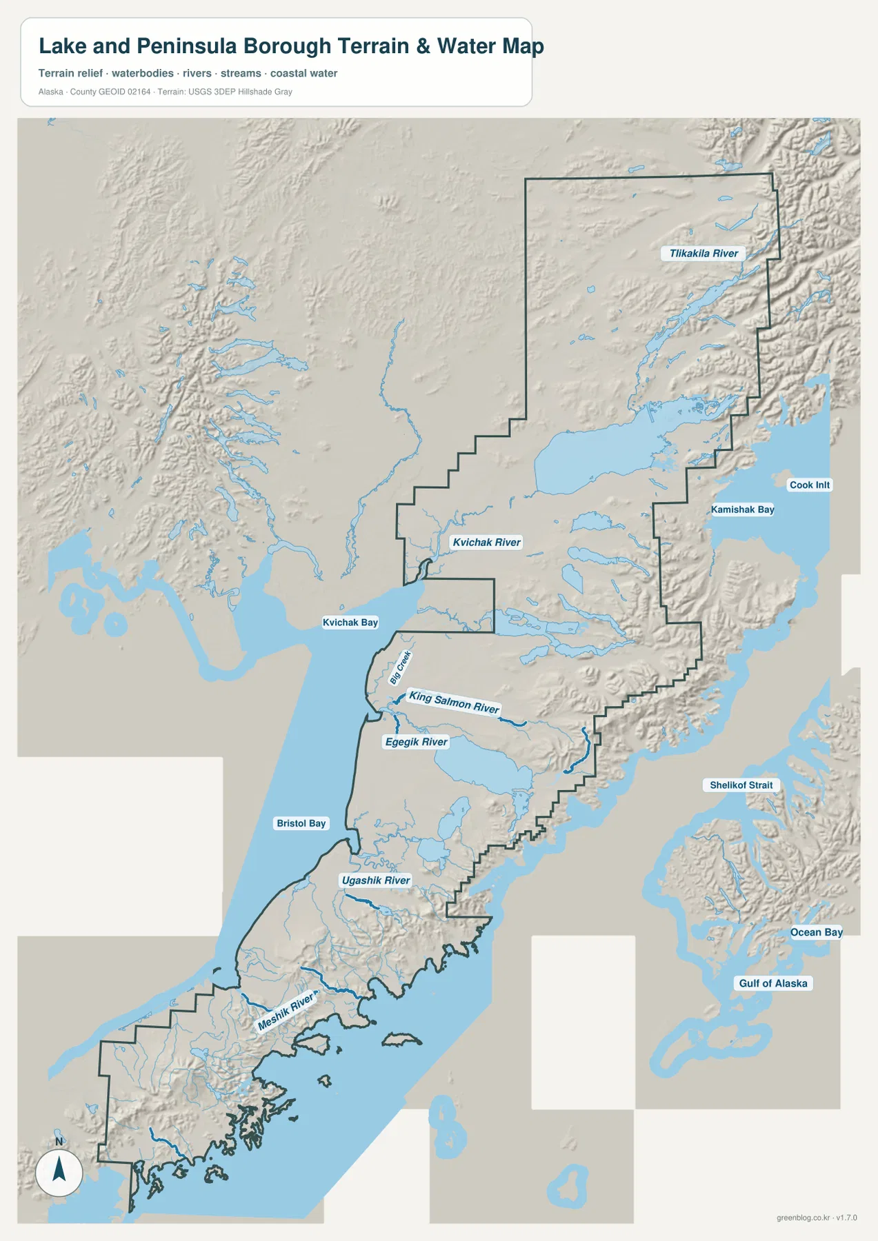
The terrain-and-water sheet adds another layer to that long north-to-south layout. Tilakakila River and Kvichak River appear in the north, while King Salmon River, Egegik River, Ugashik River, and Meshik River are labeled progressively farther south. Kvichak Bay and Bristol Bay dominate the western side, while Cook Inlet, Kamishak Bay, Shelikof Strait, and the Gulf of Alaska frame the east and southeast. Relief shading becomes stronger along much of the eastern and southern side, giving the borough a clear visual contrast between broad western water country and more rugged coastal terrain.
Table of Contents
Start in the northern lake country around Newhalen and Nondalton
Newhalen and Nondalton are the easiest pair to use as a northern reference. They are shown fairly close together, with Iliamna nearby and Port Alsworth farther to the northeast. Pedro Bay and Pope-Vannoy Landing appear along the eastern and southeastern side of the large inland-water area, while several rivers and smaller lakes fill the surrounding map. This broad northern section is much wider than the southern peninsula, so it provides a useful visual anchor before following the borough boundary toward Bristol Bay.
The northern settlement pattern is not a single line. Newhalen and Iliamna sit close to one another, Nondalton is farther north, and Port Alsworth is separated to the northeast. Pedro Bay and Pope-Vannoy Landing occupy another side of the same broad lake region. The general map is useful for these relative positions, but it does not show travel time, boat routes, seasonal access, or every local road. Those questions require more specialized transportation or local information than the supplied map provides.
Regional labels around the boundary also help with orientation. Dillingham Census Area and Bethel Census Area lie to the west and northwest in the map background, while Kenai Peninsula Borough and Kodiak Island Borough appear to the east. Those surrounding labels are contextual references rather than a substitute for exact legal boundary coordinates. When a project depends on precise administrative geometry, the U.S. Census Bureau boundary dataset should be used instead of estimating from the rendered image.
The southern chain of communities runs from Igiugig to Chignik
South of the northern lake country, Igiugig appears near the western side of the central borough. Egegik and Pilot Point are farther down the Bristol Bay coast, followed by Port Heiden on a much longer southern shoreline. Chignik sits near the lower end of the borough where the coast becomes more indented and island-studded. Ugashik is also labeled inland between Pilot Point and Port Heiden, adding another settlement reference in the middle of this long stretch.
This elongated settlement pattern is one of the most distinctive features of the supplied general map. The distance on the page between Newhalen and Chignik is large, and the borough contains long sections with relatively few place labels between the highlighted communities. King Salmon, Naknek, and South Naknek appear outside the borough near the central western edge and are useful as surrounding references when locating Egegik and Pilot Point. They should not be treated as part of the borough simply because their names appear on the same base map.
The six-place city index emphasizes separation rather than a single urban cluster
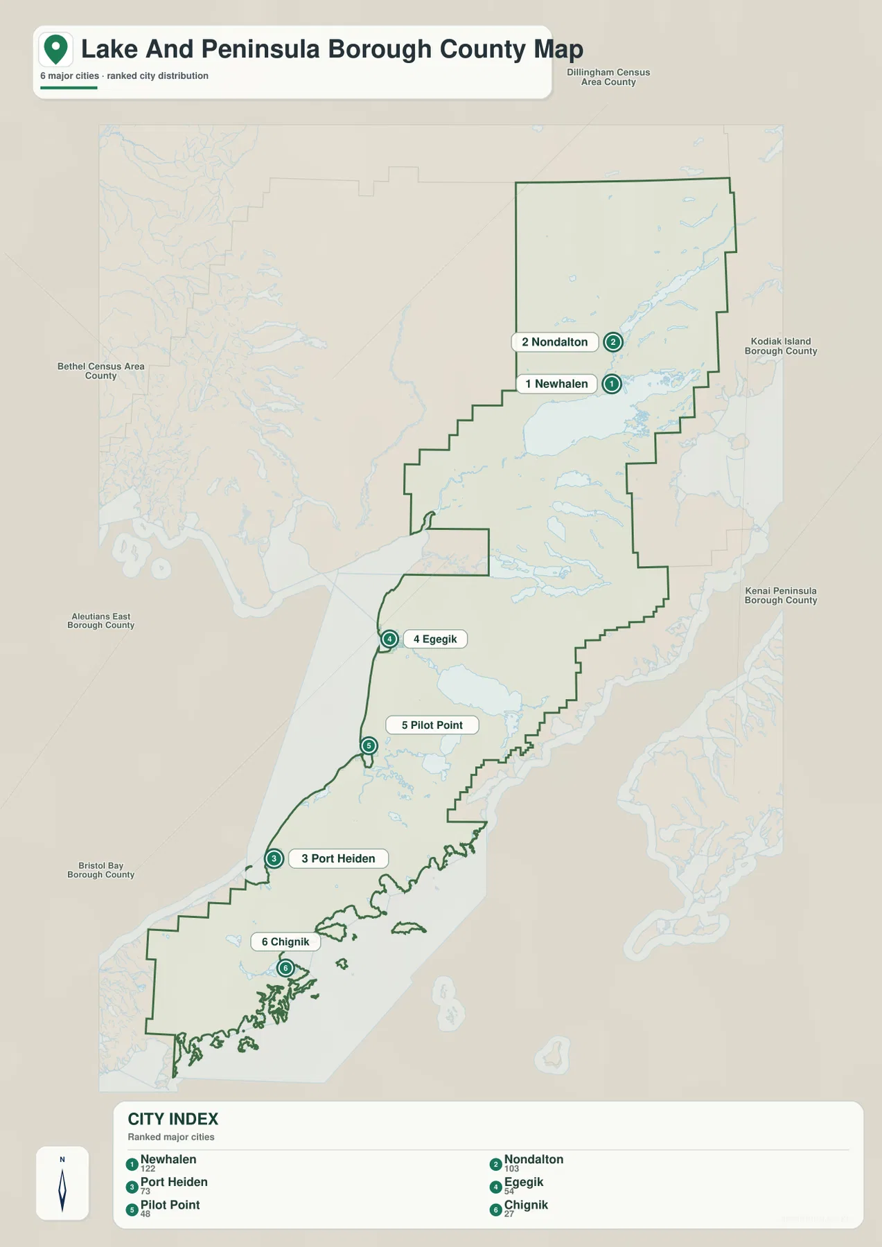
The city-index sheet selects six communities: Newhalen, Nondalton, Port Heiden, Egegik, Pilot Point, and Chignik. Newhalen and Nondalton form the only close northern pair among the six markers. Egegik and Pilot Point sit much farther south along the Bristol Bay side, Port Heiden is farther down the peninsula, and Chignik is separated near the southern end. Even without using the numeric index, the map makes the borough’s long settlement distribution immediately visible.
The printed CITY INDEX lists Newhalen 122, Nondalton 103, Port Heiden 73, Egegik 54, Pilot Point 48, and Chignik 27. These are values embedded in the supplied graphic and are best treated as map-index information rather than a claim about the latest official population. Current demographic figures should be checked separately with the U.S. Census Bureau. For this page, the more useful point is where those six communities appear relative to one another and how far the southern markers extend from the northern pair.
Kvichak River and Kvichak Bay connect the northern water country to Bristol Bay
The northern part of the terrain-and-water map is organized by large inland water and the rivers leaving it. Tilakakila River is labeled in the northeast, while Kvichak River runs toward the western side and reaches Kvichak Bay. That river-and-bay combination is a useful reference for connecting the broad northern lake region with the Bristol Bay coast. Readers who first locate Newhalen, Nondalton, and Iliamna on the general map can then use the water sheet to understand how much of the northern landscape is occupied by lakes, rivers, and connected channels.
Many smaller unlabeled lakes and tributaries are visible around the named features. On the eastern side, Cook Inlet and Kamishak Bay appear across the mountainous margin, showing that the borough reaches toward a second major coastal side rather than facing only Bristol Bay. The map is intended for relative geographic reference. It does not provide channel depth, current speed, safe navigation routes, or seasonal ice conditions, so detailed hydrographic questions should be checked with a dedicated official source.
Egegik, Ugashik, and Meshik rivers mark successive sections of the western coast
Farther south, the named rivers provide a convenient way to divide the long Bristol Bay side into sections. King Salmon River appears near the upper central coast, Egegik River is labeled beside the Egegik area, and Ugashik River occupies another broad drainage farther south. Meshik River is shown near the Port Heiden section of the peninsula. Together, these names create a sequence that matches the community pattern seen on the general map without implying that the rivers themselves form a single connected route.
Numerous smaller rivers and lakes fill the spaces between those labeled systems. The western shore often looks broad and open on the rendered terrain, while the eastern and southern margins show more pronounced relief and a more complicated coast. Near the southern end, the map becomes increasingly cut by bays, islands, and narrow shoreline forms around the direction of Chignik. Following the water map from north to south therefore shows a gradual change from large inland water and broad river mouths to a more rugged peninsula coast.
Kamishak Bay and Shelikof Strait reveal a different eastern shoreline
Cook Inlet and Kamishak Bay are labeled on the upper eastern side of the terrain-and-water sheet. Farther south, Shelikof Strait runs along the outer side of the peninsula, and the Gulf of Alaska is labeled beyond the southeastern coast. Ocean Bay also appears in that eastern coastal region. The relief shading is stronger here than across much of the western Bristol Bay side, making mountain ridges and valleys more obvious even though the map does not provide exact contour values.
This east-west contrast is useful for understanding why one map can feel like two very different landscapes. The Bristol Bay side is dominated by broad water, long river systems, and widely spaced communities. The eastern side is visually narrower and more rugged, with steep-looking relief approaching coastal water. The shaded background is only a generalized terrain reference, not survey-grade elevation. Exact height, slope, or engineering analysis requires a proper elevation dataset such as the USGS 3D Elevation Program.
Use the maps together when the question changes from place to water
The general map is the strongest starting point for the full borough outline and a broad set of place labels. It lets a reader move from Newhalen and Nondalton through Igiugig, Egegik, Pilot Point, Port Heiden, and Chignik without losing the administrative boundary. The city-index sheet is simpler when the goal is to compare six highlighted communities. The terrain-and-water sheet is the better choice for Kvichak River, Egegik River, Ugashik River, Meshik River, Bristol Bay, Kamishak Bay, and the broad difference in relief between the two sides of the peninsula.
A practical sequence depends on the question. Someone comparing Newhalen and Port Heiden can locate both on the general map, then use the city index to see how far apart the northern and southern markers appear. A reader focused on Egegik can start with the settlement map and move to the water sheet to find Egegik River and Bristol Bay. For the southern end, the general map locates Chignik while the terrain sheet supplies the more intricate coastal context around the peninsula.
- For the borough outline and many community labels: start with the general map.
- For a clean comparison of six highlighted communities: use the city-index sheet.
- For named rivers, Bristol Bay, Kamishak Bay, and broad relief: use the terrain-and-water map.
- For legal boundaries, current demographics, detailed hydrography, or exact elevation: consult the corresponding Census or USGS dataset.
The WebP images in the article are optimized for page viewing. The ZIP below contains three larger JPG originals covering the same subjects: the full borough map, the six-place city index, and the terrain-and-water map. Those files are useful for printed reference, classroom work, presentations, and personal geographic study when a larger image is preferable to the web version. High resolution does not turn them into survey plats, nautical charts, flood-hazard maps, or engineering elevation products.
Frequently Asked Questions
Where are Newhalen and Nondalton on the map?
Both communities are shown in the broad northern part of the borough near the large inland-water region. Newhalen is close to Iliamna, while Nondalton appears farther north. Port Alsworth and Pedro Bay provide additional northern reference points, so locating Newhalen and Nondalton first makes the rest of the upper borough easier to follow.
Which map is best for the Bristol Bay rivers?
The terrain-and-water map is the best choice. It labels Kvichak River, King Salmon River, Egegik River, Ugashik River, and Meshik River along with Kvichak Bay and Bristol Bay. The sheet is useful for relative position, but detailed flow, depth, navigation, and seasonal water conditions require a separate official hydrographic source.
What is included in the downloadable ZIP?
The archive contains three high-resolution JPG files corresponding to the article’s general borough map, city-index map, and terrain-and-water map. They are suitable as larger visual references for print, classroom, and presentation use. Legal boundary work, navigation, flood decisions, and engineering analysis require the appropriate authoritative datasets instead.
Map File Information
The Lake and Peninsula Borough maps used in this article are available as high-resolution JPG files. The ZIP contains the general borough map, the six-place city index, and the terrain-and-water map.
- Included Files: 3 high-resolution JPG images
- File Type: JPG files in one ZIP archive
Related Maps
Sources and further reference
Official administrative boundary files are available from the U.S. Census Bureau TIGER/Line Shapefiles. More detailed river and water data can be checked through USGS National Hydrography, while exact elevation datasets are available through the USGS 3D Elevation Program. The geographic descriptions on this page are grounded in the supplied Lake and Peninsula Borough maps and asset manifest.
Green Map creates custom-edited map images using open geographic data sources such as geoBoundaries, Natural Earth, OpenStreetMap, and government open data.
These maps are edited visual materials, not raw data files, and are provided for education, documents, presentations, and graphic reference.