Juneau City and Borough occupies a very different kind of county-equivalent landscape from a compact inland county. The Juneau urban area is concentrated near the western side of a much larger borough, while long mountain valleys, rivers, coastal water, and irregular shorelines fill most of the mapped area. The general map marks Juneau as the main settlement, with Amalga to the north and Taku Harbor farther to the southeast. Roads and public-service symbols cluster around Juneau, but the borough boundary extends far beyond that developed core. This page explains only features shown on the supplied maps and provides the same three map subjects as high-resolution JPG files that you can download in one ZIP archive.
The easiest way to understand the borough is to separate the urban reference point from the much larger natural setting around it. The city-index map ranks only Juneau, while the terrain-and-water map gives much more visual space to Lynn Canal, the northern river valleys, the Taku River system, and the rugged southeast interior. That contrast is useful: the city map tells you where the main urban point sits, the general map adds the borough outline and local reference features, and the water map shows why so much of the boundary contains mountains, channels, and river corridors rather than a continuous road network. Reading the three maps in that order keeps the geography clear without treating Juneau as if it covered the borough evenly.
Table of Contents
One ranked city inside a borough that stretches far beyond the urban core
On the general map, Juneau appears near the west-central side of the borough. The Juneau Police Department and Dimond Courthouse are labeled close to the local road network, making this the densest cluster of civic and transportation symbols on the page. Farther north, Amalga is marked separately, while the northwest coast includes Greens Creek Emergency Medical and the historical Fish Creek label. Taku Harbor appears well to the southeast of the city cluster. These points make an important map-reading distinction: Juneau is the dominant named urban center, but the borough contains long coastal and mountain sections that lie well outside that core.
The boundary itself is highly irregular. Along the west, land and coastal water repeatedly cut into one another, while the east side opens into a much broader mountainous interior. South of Juneau, narrow passages divide pieces of land before the borough extends into a long southeastern section. A simple east-west description is therefore not enough for many locations. It is often more useful to ask which channel, river valley, or shoreline a place is near. The general map is the best starting point for this because it puts the entire boundary, the Juneau road cluster, and the more distant labels on one page.
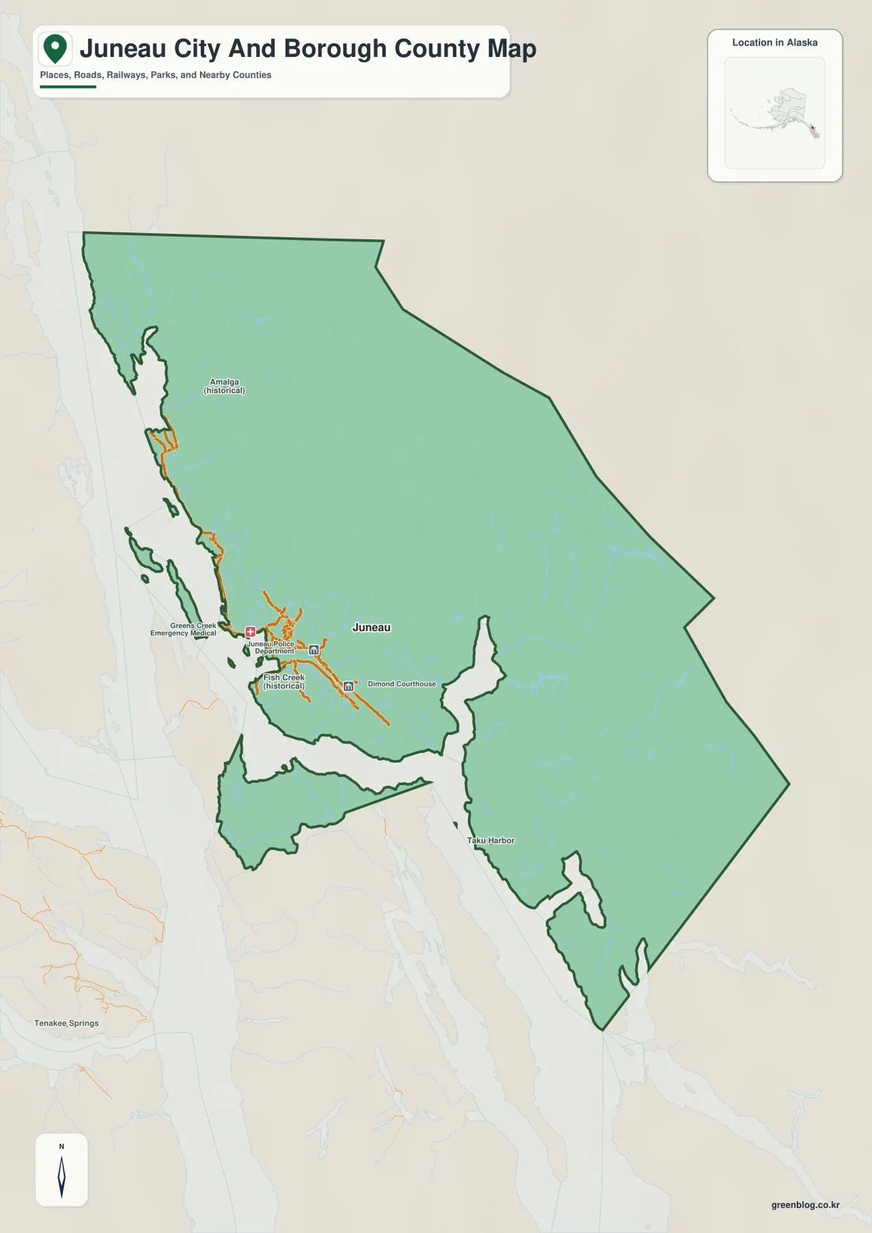
The small Alaska locator inset also helps explain the setting. Juneau City and Borough sits in Southeast Alaska, where narrow mainland sections, islands, channels, and neighboring boroughs create a much more fragmented regional pattern than in much of the interior. Tenakee Springs is visible outside the borough as a background reference, not as a place being identified inside the Juneau boundary. That distinction matters whenever the map includes labels beyond the outline. For any location discussed on this page, the borough boundary remains the guide for separating internal features from nearby regional context.
The city index reduces the whole area to one clear reference point: Juneau
The city-index map is unusually simple. It contains a single ranked marker, “1 Juneau,” and the CITY INDEX printed at the bottom lists Juneau with a value of 31,794. That figure should be treated as the value printed on the supplied map rather than automatically as the newest official population estimate. Population statistics change over time, so readers who need a current number should check the U.S. Census Bureau separately. What the index establishes clearly is that Juneau is the one major city selected by this map’s ranking method.
The background labels place the borough among Haines Borough, Hoonah-Angoon Census Area, Petersburg Borough, and Sitka City and Borough. Haines is shown to the north, Hoonah-Angoon lies to the west, and Petersburg and Sitka appear farther south and southwest. These labels are useful for regional orientation, especially for readers who know Southeast Alaska by borough names rather than by river systems. The city-index page is not a survey boundary product, however. If an exact legal or GIS boundary is required, Census TIGER/Line data or another current official boundary source should be used.
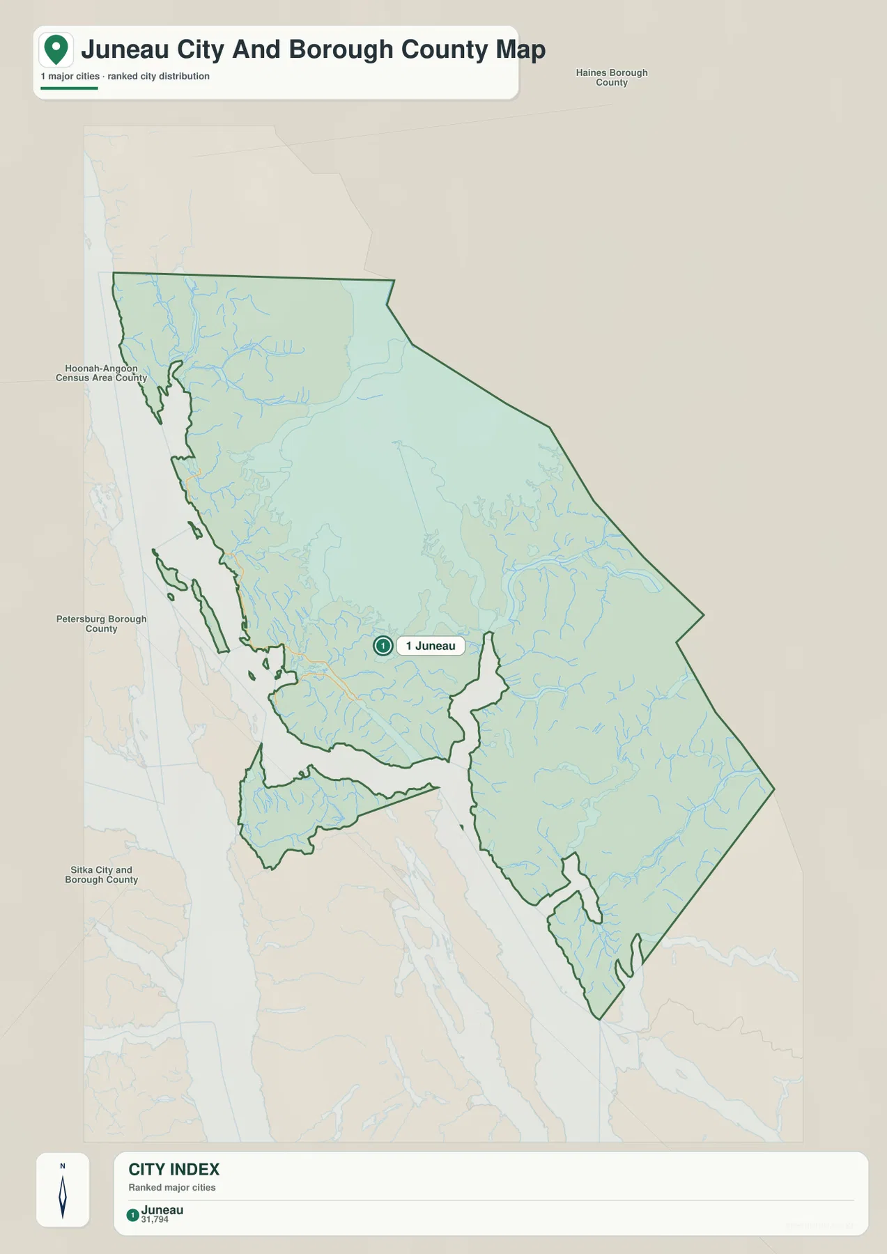
Because there is only one ranked city, this map is not about comparing connector lines or distances between multiple urban centers. Instead, it works as a clean anchor for the other two maps. Once Juneau is located, the reader can return to the general map to see Amalga, Taku Harbor, roads, and public-service symbols, then move to the water map to understand the broad mountain-and-river area surrounding the city. This one-point index is especially useful on a page where the natural geography occupies much more space than the urban geography.
Lynn Canal and four named rivers organize the northern part of the map
Lynn Canal is the dominant water reference along the northwestern side of the terrain-and-water map. Inland from that coastal corridor, Berners River, Lace River, Antler River, and Gilkey River are all labeled across the northern mountain valleys. The rivers do not form one straight parallel set. Each follows its own valley through the relief before approaching the coast. This is one of the clearest differences between the general map and the water map: the north may look lightly labeled on the general page, but the terrain page reveals a dense network of streams and valleys occupying the same area.
Berners River is shown close to the northwest side, with Lace River to the east and Antler River farther into the mountainous interior. Gilkey River appears south of those northern labels. Following the four names one by one gives the reader a practical way to break a large, visually rugged area into smaller pieces. They also show why a city-only description would miss much of the borough. Juneau may be the only ranked city, yet a substantial part of the mapped territory is better understood through rivers, ridges, and coastal water than through settlement names.
Icy Strait and Chatham Strait are labeled outside and southwest of the borough, adding broader regional context. These names help orient the western and southern waters, but the map should not be treated as a nautical chart. It does not provide navigational depth, tides, currents, channel restrictions, or marine safety information. The blue water shapes and named straits are geographic references only. Boating or marine planning requires current navigation products designed for that purpose.
Taku River, Speel River, and Whiting River cut through the broad eastern mountains
The eastern half of the terrain map is dominated by rugged shaded relief and long river valleys. Taku River is one of the largest named channels on this side of the borough. It is drawn prominently east of the Juneau urban area, with Johnson Creek labeled nearby. When the general map and water map are compared, the contrast is immediate: the road and civic symbols around Juneau give way to a large interior where river corridors and mountain relief become the primary references.
Farther southeast, Speel River and Whiting River follow separate valleys toward coastal water. The relief around them is heavily textured with ridges and valleys rather than broad flat areas. Seymour Canal is labeled south of the central borough, while Endicott Arm appears farther to the southeast. Tenakee Inlet is visible to the southwest outside the main boundary as another regional water reference. These names help break the southern half into recognizable sections without inventing roads or settlements where the supplied map does not show them.
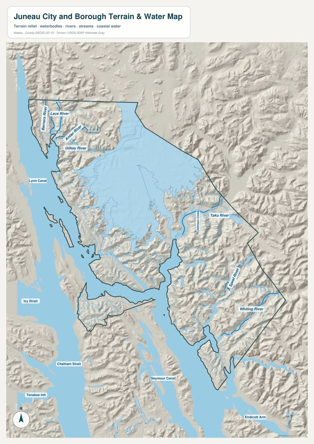
The shaded terrain makes the borough’s mountain character easy to see even without numerical elevation labels. Ridges and deeply cut valleys dominate the north and east, while the urban map symbols occupy a much smaller area near the western side. The map does not provide survey-grade elevations or parcel-scale slope measurements, so it should not be used to decide construction suitability, engineering grade, avalanche exposure, or exact summit height. For those questions, a dedicated elevation dataset such as the USGS 3D Elevation Program is the more appropriate source.
The same caution applies to the rivers. Their approximate paths and names are useful for geographic orientation, but the map is not a flood-hazard layer, drinking-water assessment, fishery regulation map, or hydrographic navigation product. If a reader needs an official water network or more detailed stream information, USGS National Hydrography is a better reference. The value of this page is in showing how the main water systems and mountainous terrain fit around Juneau, not in replacing specialized environmental or engineering data.
Roads and civic landmarks occupy a narrow part of a much larger landscape
The general map gives much more detail to roads around Juneau than to the interior east of the city. The road lines form a compact network around the main urban area, near the Juneau Police Department and Dimond Courthouse markers. As the map extends toward Amalga in the north or Taku Harbor in the southeast, road symbols become much less prominent. This is a visual observation from the supplied map, not a statement that those areas are inaccessible or that a specific road is open or closed. Current transportation conditions require a dedicated road, ferry, airport, or local travel source.
The map also contains specialized labels such as Greens Creek Emergency Medical and the historical Fish Creek marker. They are useful local reference points, but they should not be mistaken for a complete directory of hospitals, historic sites, or public facilities. A visitor looking for an address, service status, emergency coverage, or operating hours should use the responsible agency’s current information. On this map, those labels simply help show how selected facilities and historical references relate to the Juneau road cluster and the western shoreline.
This concentration of urban detail is one reason the three-map set works better than any single image alone. The general map provides names and roads, the city index strips the picture down to Juneau as the primary city reference, and the terrain map expands the view again to mountains, rivers, and coastal channels. Switching among those scales keeps the page useful for both a reader interested in the city and someone trying to understand the much larger borough.
Reading the three maps together clarifies the borough’s coastal and regional setting
A practical sequence is to begin with Juneau on the general map, note Amalga and Taku Harbor, and trace the outline around the borough. Next, the city index confirms that Juneau is the only ranked major city on the supplied urban page. Finally, the terrain map can be used to locate Lynn Canal, the four northern rivers, Taku River, Speel River, Whiting River, and the large southern channels. This sequence turns what first looks like an irregular shape into a set of recognizable geographic zones.
The surrounding labels add another layer of orientation. Haines Borough, Hoonah-Angoon Census Area, Petersburg Borough, and Sitka City and Borough appear on the city map, while Icy Strait, Chatham Strait, Seymour Canal, and Endicott Arm appear on the terrain map. Administrative names and water names therefore describe two different ways of locating Juneau within Southeast Alaska. The first tells you which boroughs or census areas are nearby; the second tells you which large waterways and mountain corridors shape the physical setting.
- Boundary, roads, and local reference points: use the general map for Juneau, Amalga, Taku Harbor, civic symbols, and the full borough outline.
- Urban orientation: use the city index to locate Juneau quickly and see the surrounding borough and census-area labels.
- Rivers, channels, and mountains: use the terrain-and-water map for Lynn Canal, the northern rivers, Taku River, Speel River, Whiting River, and the broad relief pattern.
- Exact or current decisions: use official boundary, population, transportation, navigation, hydrography, or elevation sources when precision matters.
Choosing the right map for printing, classwork, or a quick location check
The general map is the best choice when the main question is where Juneau sits inside the borough and how roads, selected landmarks, and distant labels relate to the boundary. The city-index map is cleaner when a simple regional reference is needed and Juneau is the only city that needs emphasis. The terrain-and-water map is the strongest option for explaining why the borough looks so irregular: mountain valleys, rivers, channels, and coastal water occupy most of the page. Using the map that matches the question avoids forcing one image to do every job.
For a classroom presentation, one useful progression is to begin with the general map, move to the single-city index, and then finish with the terrain-and-water map. That order starts with familiar urban references and then expands into the much larger physical landscape. For printing or offline work, the ZIP below contains the three matching high-resolution JPG files rather than the smaller WebP images used in the article. The files are suitable for visual reference, but higher resolution does not turn them into legal surveys, engineering maps, flood studies, or navigation charts.
Frequently Asked Questions
Why does the city index show only Juneau?
The supplied city-index map ranks Juneau as the single major city in this borough. The general map still includes other labels such as Amalga, Taku Harbor, selected civic facilities, and historical reference points. The two maps use different display purposes, so a place can appear on the general map without being part of the ranked city index.
Which map is best for seeing Lynn Canal and Taku River together?
The terrain-and-water map is the best choice. It shows Lynn Canal in the northwest, Berners, Lace, Antler, and Gilkey Rivers across the north, Taku River and Johnson Creek in the east, and Speel and Whiting Rivers farther southeast. The shaded relief also makes it easier to see how the named rivers fit within the mountain terrain.
What is included in the downloadable ZIP?
The archive contains three high-resolution JPG files matching the subjects used in the article: the general borough map, the city-index map, and the terrain-and-water map. It does not include a survey plat, flood-hazard layer, nautical chart, or live traffic map. The files are intended for geographic reference, printing, presentations, and educational use.
Map File Information
The Juneau City and Borough maps shown in this article are available as high-resolution JPG files. The ZIP bundles larger originals for printing, classroom use, presentations, and offline geographic reference.
- Included Files: 3 high-resolution JPG images
- File Type: JPG files in one ZIP archive
Related Maps
Sources and further reference
For local government and borough information, see the City and Borough of Juneau official website. Current population and geographic statistics are available from U.S. Census Bureau QuickFacts. For boundary data, use Census TIGER/Line Shapefiles; for official hydrography, see USGS National Hydrography; and for detailed elevation data, see the USGS 3D Elevation Program.
Green Map creates custom-edited map images using open geographic data sources such as geoBoundaries, Natural Earth, OpenStreetMap, and government open data.
These maps are edited visual materials, not raw data files, and are provided for education, documents, presentations, and graphic reference.