Mississippi does not have a single population center that explains the whole state. The supplied 2024 ACS 5-year data place the population at 2,946,779. The county-density map lists about 46,925 square miles of land and a statewide average near 63 people per square mile, but the detailed map is much more uneven. Dense tracts cluster around Jackson, along the Gulf Coast, and in the northern suburbs near the Tennessee line, while broad rural areas remain lightly settled.
The rankings also change depending on the measure. Hinds County has the largest current population, DeSoto County has the highest county-average density, and Lafayette County posted the fastest percentage growth from 2010 to 2020. Several Delta counties moved in the opposite direction and recorded some of the largest declines. Reading the maps as separate measures of size, concentration, and change avoids treating a large population circle or a dark density shade as if they meant the same thing.
Table of Contents
Census tracts reveal three major concentration zones rather than one continuous urban belt
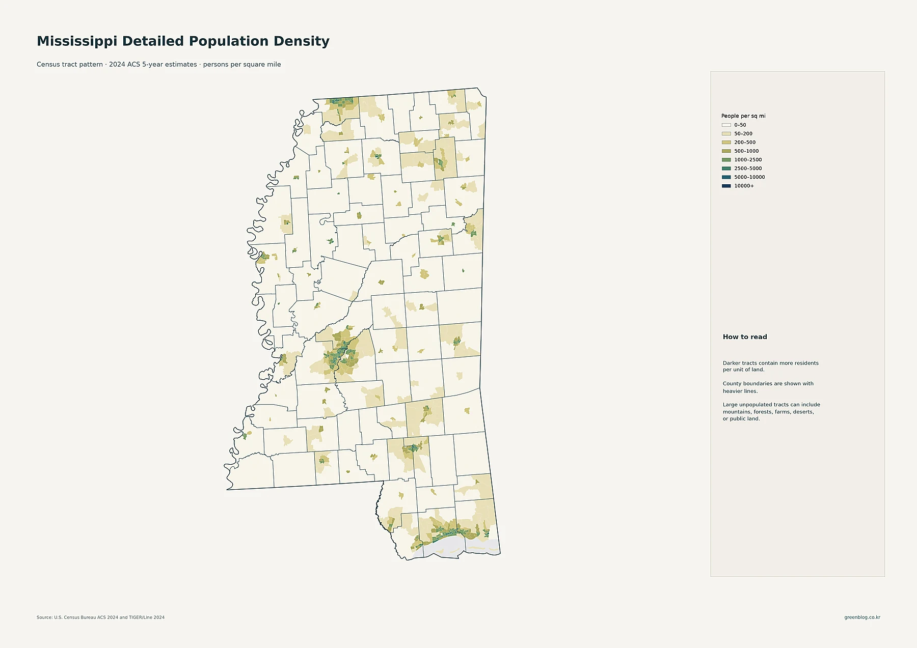
The Jackson area is the clearest inland cluster. Darker tracts in Hinds County connect with populated parts of Rankin and Madison counties, showing a metropolitan footprint that crosses county lines. This is exactly where tract geography adds value: a countywide average gives every part of a county one number, while the tract map shows dense neighborhoods and corridors next to much lighter outer areas.
A second concentration follows the Gulf Coast. Dense tracts extend around Gulfport and Biloxi in Harrison County and appear again around Pascagoula in Jackson County. At the northern edge of the state, Southaven, Horn Lake, and Olive Branch form another visible cluster in DeSoto County. Smaller but distinct concentrations appear around Hattiesburg, Tupelo, Meridian, Oxford, Starkville, Columbus, and Greenville. Between those centers, especially across large rural sections of the Delta and eastern Mississippi, many tracts fall into the lightest density classes.
Jackson is the largest place, but the map also shows strong coastal and northern city groups
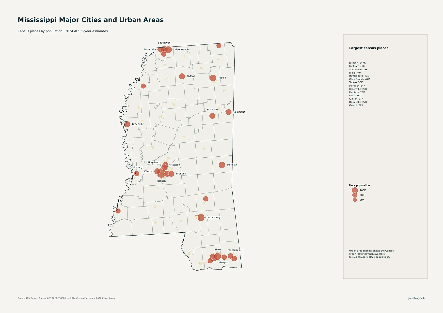
Jackson is the largest census place in the supplied file with 146,631 residents. Gulfport follows at 73,003 and Southaven at 56,226. Biloxi has 48,861 residents, Hattiesburg 48,619, Olive Branch 47,019, Tupelo 37,791, and Meridian 34,137. Greenville has 28,166. Around Jackson, Madison has 27,946 residents, Pearl 27,737, Clinton 27,195, Ridgeland 24,587, and Brandon 25,542.
The placement of those circles matters as much as the ranking. Jackson is surrounded by several substantial places, so the central cluster spreads beyond one municipality. Gulfport and Biloxi help form an east-west coastal group, with Pascagoula farther east. Southaven, Olive Branch, and Horn Lake sit close together in DeSoto County at the state’s northern tip. Oxford and Starkville appear as separate regional centers. Circle size on this map represents place population only; it should not be read as a direct measure of land-area density.
Hinds leads county population, while Harrison and DeSoto form a close second tier
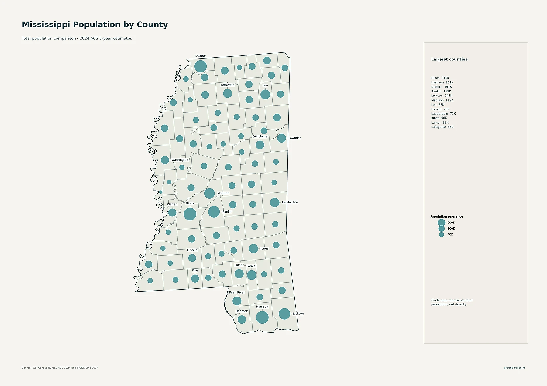
Hinds County has 218,533 residents, the largest current county total in Mississippi. Harrison County is close behind with 210,891, followed by DeSoto County with 191,301. Rankin has 158,854 residents, Jackson 145,249, and Madison 111,647. The next group includes Lee at 83,034, Forrest at 78,272, Lauderdale at 71,504, Jones at 66,472, Lamar at 65,713, and Lafayette at 58,327.
The largest circles therefore appear in several different parts of the state: Hinds, Rankin, and Madison around Jackson; Harrison and Jackson along the coast; and DeSoto in the north. That pattern is not the same as the density ranking. Hinds averages about 251 people per square mile, but DeSoto averages about 402 and Harrison about 368. A proportional circle answers “how many residents are in the county,” whereas the shaded density map answers “how many residents occupy each square mile of land.”
DeSoto has the highest county density, with the Gulf Coast and Jackson area close behind
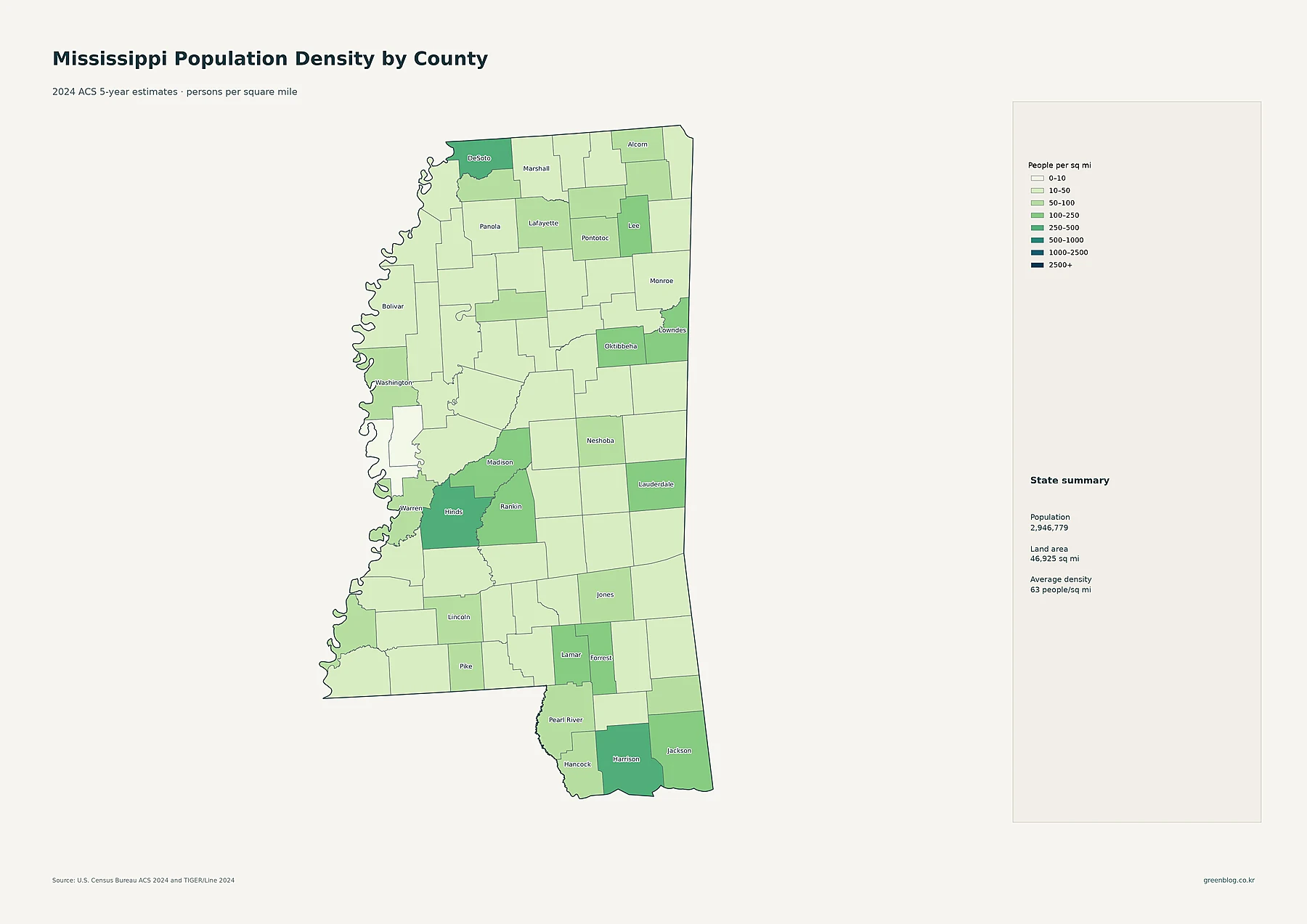
DeSoto County averages about 401.6 people per square mile, the highest county value in the supplied data. Harrison County follows at roughly 367.6, Hinds at 251.2, Rankin at 204.8, and Jackson at 200.9. Lee County averages about 184.5, Forrest 168.0, Madison 156.3, and Lamar 132.3. The county map therefore reinforces the same three broad concentration zones visible at tract scale: northern DeSoto, central Jackson and its suburbs, and the Gulf Coast.
The sparse end of the distribution is dramatically different. Issaquena County averages only about 2.2 people per square mile, Sharkey about 9.0, Kemper 11.4, Wilkinson 12.0, Franklin 13.5, Jefferson 13.6, and Quitman 14.3. A statewide average of 63 compresses those extremes into one number. Greenville, for example, appears as a localized urban concentration in the Delta even though surrounding counties can have very low countywide averages. Looking at both tract and county scales keeps those local pockets from disappearing.
| Measure | Standout area | Value in the supplied data |
|---|---|---|
| State population | Mississippi | 2,946,779 |
| Largest county population | Hinds County | 218,533 |
| Highest county density | DeSoto County | about 402/sq mi |
| Fastest 2010–2020 growth | Lafayette County | +17.9% |
| Largest 2010–2020 decline | Quitman County | -24.9% |
The 2010–2020 map separates faster-growing counties from a broad Delta decline pattern
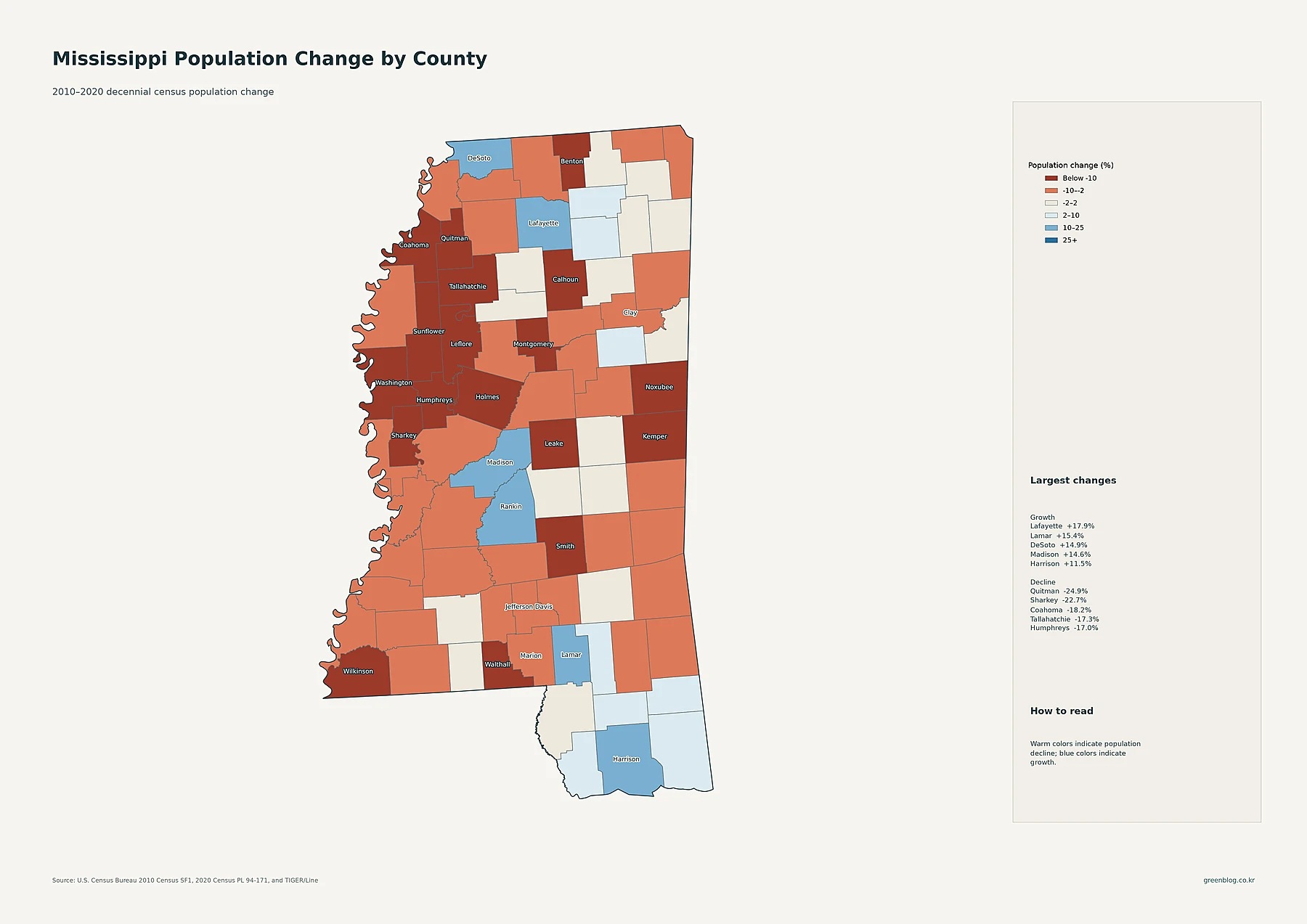
Lafayette County grew from 47,351 residents in 2010 to 55,813 in 2020, an increase of about 17.9%, the largest percentage gain in the file. Lamar County grew 15.4%, DeSoto 14.9%, Madison 14.6%, Harrison 11.5%, and Rankin 10.9%. Growth is not confined to one continuous region: the blue areas include northern counties, Jackson-area suburbs, the Hattiesburg area, and parts of the coast. Hinds County, despite remaining the largest county in the 2024 ACS data, declined about 7.2% between the two censuses.
The strongest declines cluster more clearly in and near the Delta. Quitman County fell from 8,223 residents in 2010 to 6,176 in 2020, a decline of about 24.9%. Sharkey declined 22.7%, Coahoma 18.2%, Tallahatchie 17.3%, and Humphreys 17.0%. Washington County declined 12.2% and Sunflower 11.8%. These percentages establish where population changed and by how much; they do not by themselves identify the cause. Migration, births and deaths, employment, housing, and other explanations require separate evidence.
Mississippi is easier to understand as a network of population centers and sharp county contrasts
Taken together, the maps show a state organized around several distinct population zones. Jackson and its neighboring communities create the strongest central cluster. The Gulf Coast forms a second belt around Harrison and Jackson counties. DeSoto County stands out in the north, where several large places sit close together. Hattiesburg, Tupelo, Meridian, Oxford, Starkville, Columbus, and Greenville add smaller regional centers that interrupt otherwise low-density areas.
The Delta adds a different dimension because many counties there combine low current density with substantial 2010–2020 population loss. That makes the distinction among measures especially important. Hinds is the largest county by current population, DeSoto is the densest county, and Lafayette was the fastest-growing county over the decennial period. No single ranking can represent all three. Moving from tract density to place totals, county totals, county density, and finally population change gives a more accurate picture of where Mississippians live and how that pattern has shifted.
Download the Mississippi population map collection
The ZIP collection includes detailed census-tract density, major cities and urban areas, county population totals, 2010–2020 population change, and county population density.
FAQ
Which Mississippi county has the largest population?
Hinds County is largest in the supplied 2024 ACS data with 218,533 residents. Harrison County follows with 210,891, and DeSoto County has 191,301.
Is Hinds County also the densest county in Mississippi?
No. DeSoto County has the highest county-average density at about 402 people per square mile, followed by Harrison at about 368 and Hinds at about 251. Total population and population density measure different things.
Which Mississippi county grew fastest from 2010 to 2020?
Lafayette County recorded the largest percentage increase at about 17.9%, followed by Lamar County at 15.4% and DeSoto County at 14.9%. These figures compare the 2010 and 2020 decennial censuses.
Related Maps
Sources
- U.S. Census Bureau — American Community Survey (ACS): 2024 5-year population and density estimates
- U.S. Census Bureau — TIGER/Line Shapefiles: 2024 state, county, census tract, and place geography
- U.S. Census Bureau — Decennial Census: 2010 and 2020 county population comparison
Green Map creates custom-edited map images using open geographic data sources such as geoBoundaries, Natural Earth, OpenStreetMap, and government open data.
These maps are edited visual materials, not raw data files, and are provided for education, documents, presentations, and graphic reference.