The Pearl River County Mississippi map links the northern county seat at Poplarville with Picayune in the south along I-59 and US 11, while McNeill and Carriere fill the central corridor. The Pearl River, Louisiana boundary, and broad Piney Woods frame growth tied to Gulf Coast and New Orleans access.
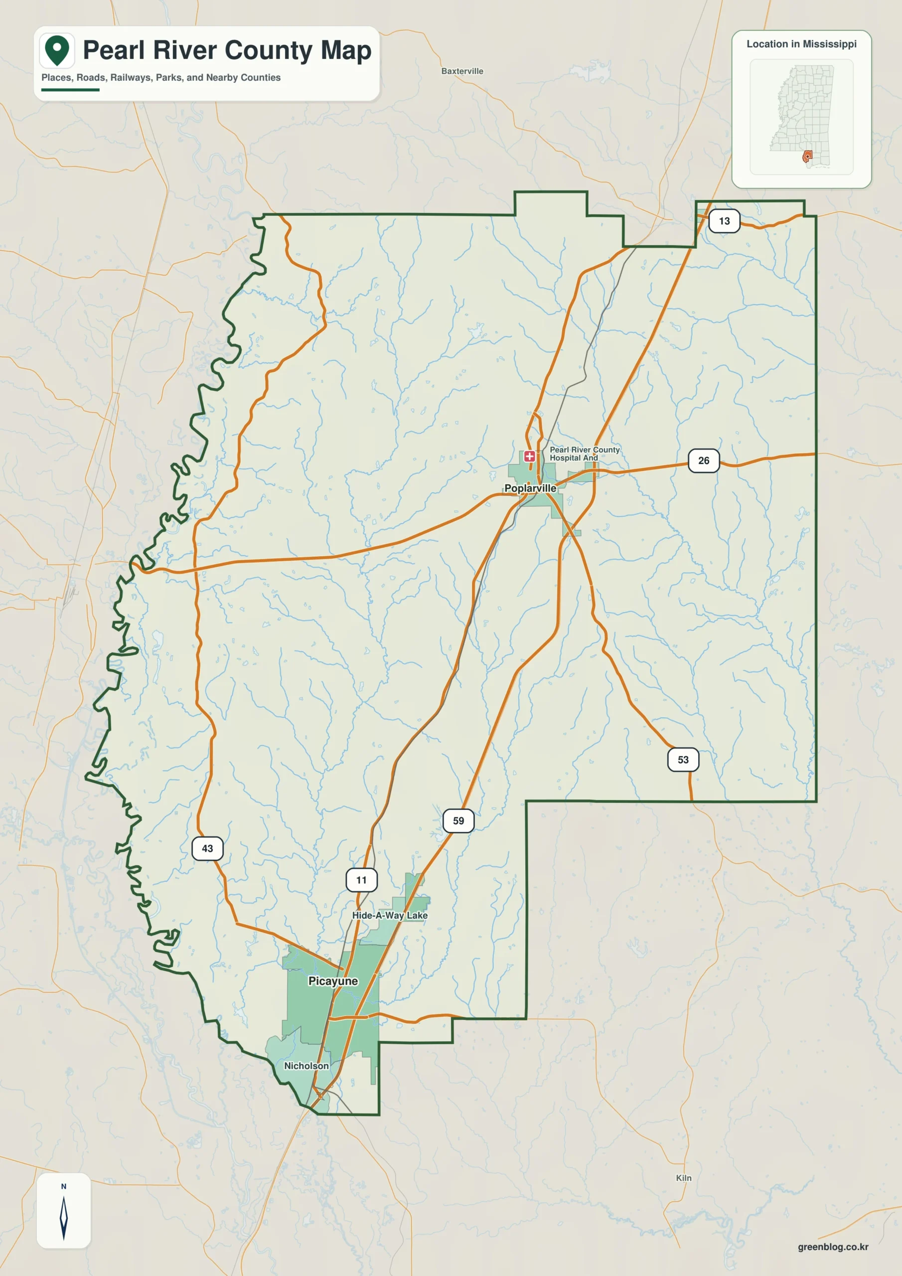
Pearl River County Mississippi map download
The WebP preview is optimized for the page, while the button preserves the original high-resolution JPG for printing and reuse.
- File: County reference map
- Format: JPG
- Print layout: A3
Quick Facts
- State and identifier: Mississippi, Pearl River County; FIPS 28109
- County seat: Poplarville
- Selected map labels: Poplarville, Picayune, McNeill, Carriere
- 2020 census population: 56,145
- July 2025 population estimate: 59,363
- 2025 Gazetteer area: 811.508 sq mi land and 7.836 sq mi water
- 2020 land-area density: 69.2 residents per sq mi
- Primary route references: I-59, US 11, MS 26, and MS 43
- Landscape references: Pearl River, Bogue Chitto tributaries, rolling Piney Woods, and Gulf Coastal Plain streams
The decennial count and July 2025 estimate use different reference dates. Land and water measurements come from the 2025 Gazetteer. The density of 69.2 residents per square mile divides the 2020 population by 2025 land area and does not imply an even distribution among cities, farms, forest, or wetland.
Reading the Pearl River County Mississippi map
I-59 and US 11 connect Poplarville with McNeill, Carriere, Picayune, and the Louisiana approach. MS 26 supplies an east-west route from Poplarville toward Stone County, and MS 43 serves inland travel near Picayune. Subdivision streets and forest tracks are simplified on the county reference map.
Boundary, Water, and Terrain
The Pearl River forms important portions of the western boundary opposite Washington and St. Tammany parishes. To the east, land continues into the Gulf Coastal Plain of Stone and Harrison counties. Pine-covered hills are more pronounced in the north, while lower and wetter stream terrain increases southward across more than 800 land square miles.
Settlement and Regional Context
Poplarville is the administrative center and home of Pearl River Community College. Picayune is the larger southern commercial and residential center, and Carriere and McNeill identify the growing corridor between them. The 2025 estimate is about 5.7 percent above the 2020 count, a notable increase for southern Mississippi.
Practical Map Uses
- Compare Poplarville and Picayune along I-59
- Relate the Pearl River to the Louisiana boundary
- Use McNeill and Carriere to explain the central growth corridor
Frequently Asked Questions
Does the Pearl River form the entire western boundary?
The river system provides an important Louisiana boundary reference, but the full line is not simply one uninterrupted main channel. Tributaries and surveyed boundaries also matter.
How can Pearl River clarify the part of Pearl River County facing Lamar?
Looking only at Poplarville would reduce the map to town labels, whereas Pearl River explains the landscape transition toward Lamar.
Sources
- U.S. Census Bureau QuickFacts
- U.S. Census Bureau 2025 Gazetteer Files
- Mississippi Department of Transportation official highway map
- Regional landscape or institution reference
Related County Maps
Green Map creates custom-edited map images using open geographic data sources such as geoBoundaries, Natural Earth, OpenStreetMap, and government open data.
These maps are edited visual materials, not raw data files, and are provided for education, documents, presentations, and graphic reference.