The easiest way to understand Perry County is to place Marion and Uniontown on the same page and then trace the Cahaba River between the county’s higher northern ridges and lower southern Black Belt country. This Perry County map page includes downloadable files as well as four separate views of the county: roads and boundaries, the two major mapped cities, named waterways, and elevation. A ZIP containing four original A3 high-resolution JPG files is available in the download box below, so the maps can be used beyond the smaller web previews.
Perry County is often associated with Alabama’s Black Belt, but the supplied maps show that the county is not one uniform plain. Marion sits in the north-central interior where several state routes meet, Uniontown occupies the southwestern extension near U.S. 80, and the Cahaba River runs through a lower central corridor before continuing toward the Alabama River system. The elevation view adds another layer: the mapped terrain ranges from about 30 to 188 meters, with more closely spaced ridges in the north and northeast and broader low ground along the river and southern county.
Table of Contents
Perry County between Black Belt lowlands and northern ridges
Perry County lies in west-central Alabama. Bibb County borders it on the north, Chilton County on the northeast, Dallas County on the southeast, Marengo County on the southwest, and Hale County on the west. The existing county material describes this location as a transition between the Black Belt and more wooded uplands to the north. That change is visible in the supplied elevation map, where the central Cahaba corridor is lower and greener while many northern and northeastern ridges rise into warmer colors.
| State | Alabama |
|---|---|
| County | Perry County |
| County seat | Marion |
| 2025 population estimate | 7,425 |
| 2020 census population | 8,511 |
| 2020 land area | 719.67 square miles |
| 2020 population density | 11.8 people per square mile |
| Major roads shown | U.S. 80, AL 5, AL 14, AL 45, AL 175, AL 183, AL 219 |
| Primary water feature | Cahaba River and its tributaries |
| Mapped elevation | Actual 30–188 m, mean 85 m |
The demographic figures in the supplied article reinforce the county’s low-density character. The Census Bureau estimate for July 1, 2025 is 7,425 residents, compared with 8,511 people counted in the 2020 census and 10,591 in 2010. With 719.67 square miles of land and a 2020 density of only 11.8 people per square mile, the large spaces between towns matter as much as the towns themselves. Forest tracts, farms, small settlements, creek valleys, and long rural road segments occupy much of the map.
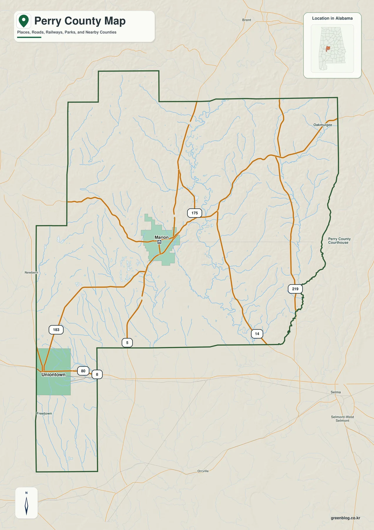
Marion appears slightly west of the county’s center and serves as the clearest road reference. Alabama 5 passes through the city, while Alabama 14 and 45 add east-west and north-south connections. Alabama 175 extends northward, and Alabama 219 is visible near the eastern side. Uniontown lies much farther southwest in the county’s long southern extension, close to U.S. 80 and Alabama 183. The separation between the two cities is one of the most useful facts on the map because it explains why Perry County does not operate around a single compact urban area.
The county outline is also unusually useful for orientation. Its western and southwestern sections step outward rather than forming a simple rectangle, and the Uniontown side extends south in a narrow shape. Labels outside the boundary—including Brent, Newbern, and Selma—provide direction toward neighboring communities without implying that those places are inside Perry County. For a visitor who needs roads, county edges, and settlement context on one page, this is the best of the four maps to begin with.
Marion and Uniontown anchor two different parts of the county
The city map deliberately simplifies the county to two ranked major cities. Marion is marked as number 1 and Uniontown as number 2. The map index displays 2,886 beside Marion and 1,798 beside Uniontown; those figures are part of the supplied city-map ranking and should not be treated as a substitute for a current official population table. What matters most here is the geography: Marion is in the north-central interior, while Uniontown is near the southwestern edge, leaving a broad rural area between them.
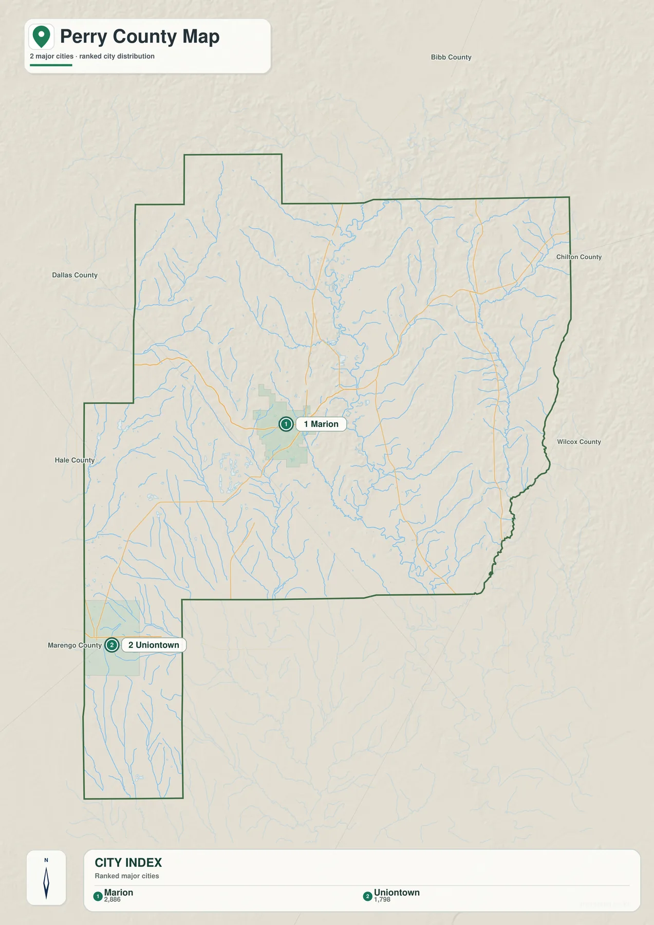
Marion is the county seat and the main administrative and educational center in the existing county material. The courthouse and county offices are associated with Marion, and Alabama 5, 14, and 45 make the city a practical road hub. Marion has served as the county seat since 1823 after the government moved from Perry Ridge. The city’s educational history also includes Howard College and Marion Military Institute, while its downtown is tied to important events in the 1965 voting-rights movement.
Uniontown has a different setting. It lies in the southern Black Belt portion of the county near U.S. 80, where the terrain is generally lower and more open than the ridge-and-forest country farther north. U.S. 80 provides an east-west framework toward Selma and the wider Black Belt corridor, while Alabama 183 and local roads connect the city with surrounding rural areas. Comparing the two city locations helps explain why a county with only two incorporated municipalities still has more than one geographic center.
The Cahaba River organizes Perry County’s water network
The water map gives the Cahaba River the strongest visual presence. It enters from the north, bends through the county’s central interior, and continues southward, receiving many smaller creeks along the way. The existing article identifies the Cahaba as Perry County’s defining water corridor and connects it with floodplain forest, swamps, tributary valleys, and old river channels. Once the river is visible, the curving road pattern and the broad gaps between settlements make more sense.
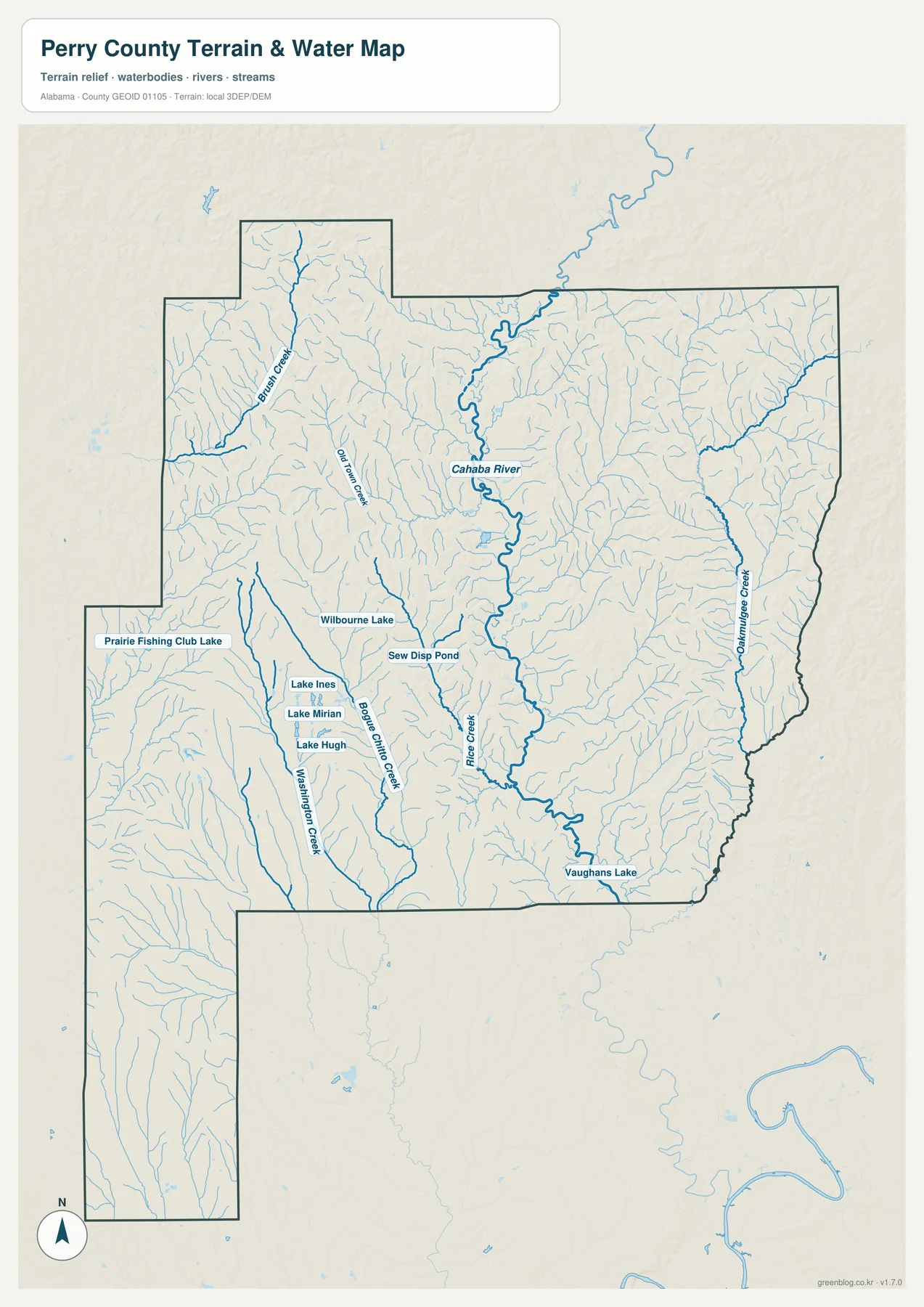
Several named tributaries stand out when the map is enlarged. Brush Creek is labeled in the northwest, Oakmulgee Creek on the east, and Bogue Chitto Creek farther south and west of the Cahaba. Rice Creek and Washington Creek are also labeled, while the smaller blue lines show how extensively the county is dissected by drainage. The map therefore works well for understanding where named streams sit relative to roads and county sections, not just for locating the main river.
The map also identifies small water bodies such as Prairie Fishing Club Lake, Wilbourne Lake, Lake Ines, Lake Miriam, Lake Hugh, and Vaughans Lake. West of Marion, the existing county material describes Perry Lakes Park as roughly 800 acres of floodplain habitat with several oxbow lakes, swamp, former fish-hatchery ponds, and trails. That context helps explain why water features around the Cahaba can be numerous even when the county does not contain a single large reservoir. This is a reference map for waterways and terrain; it is not a flood-risk, legal-boundary, or navigation chart.
Elevation from 30 to 188 meters reveals the central river lowland
The elevation map reports an actual range of 30 to 188 meters and a mean of 85 meters. The lowest colors form a broad corridor through the central county along the Cahaba River and continue into lower southern ground. In contrast, closely spaced ridges appear across much of the north, northeast, and parts of the west. The visual difference is strong enough to show why describing all of Perry County simply as flat Black Belt land would miss much of the northern landscape.
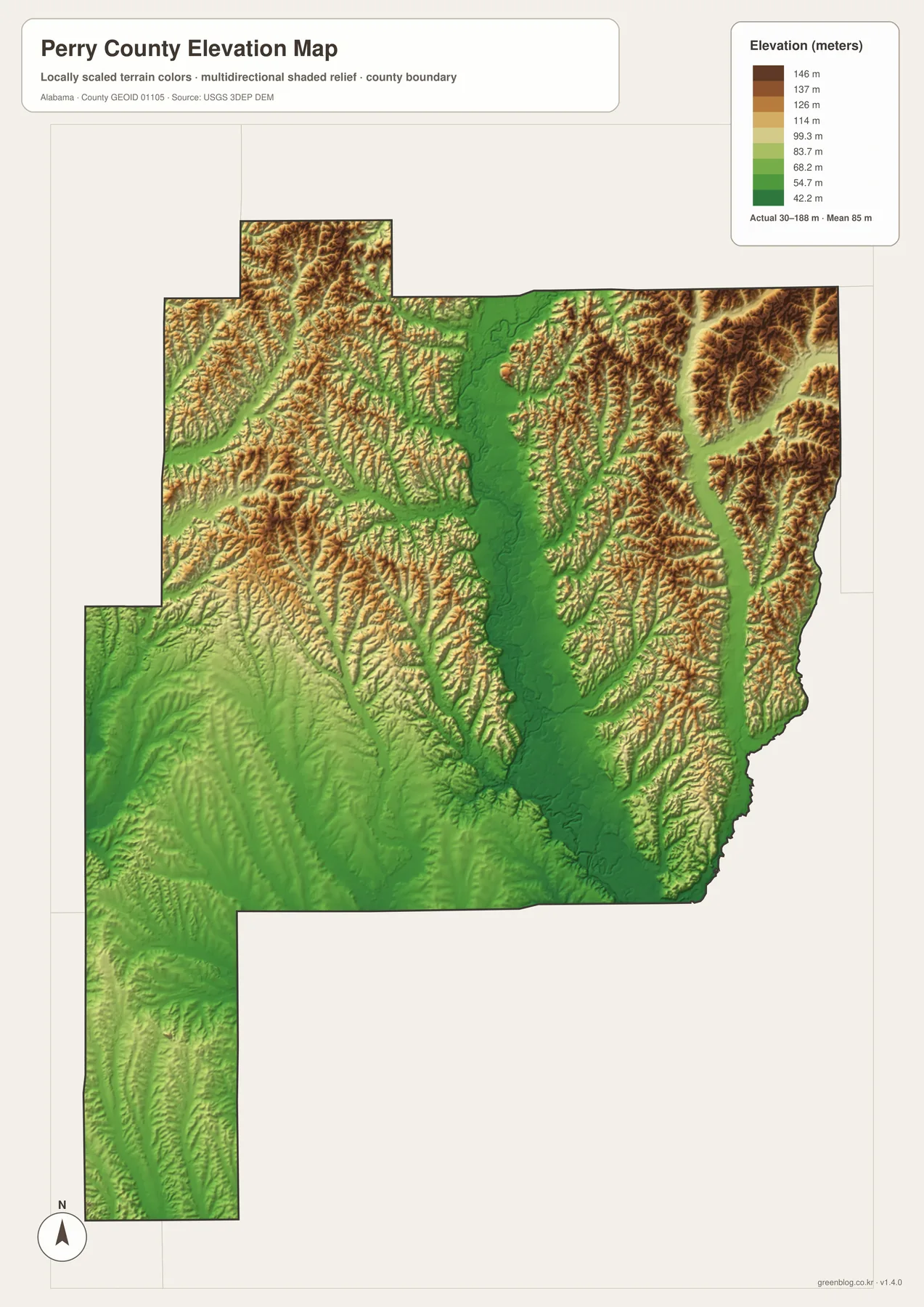
Marion sits near the meeting point between the lower river corridor and surrounding rolling terrain rather than on the county’s highest ridges. Uniontown is farther south in a broader lowland setting. Northeast toward the Oakmulgee side of the county, the relief becomes more textured and ridge-dominated. When the city and elevation maps are compared, the difference between Marion and Uniontown becomes more than a matter of distance: each city occupies a distinct physical setting.
This terrain surface is appropriate for county-scale comparison, classroom work, trip planning, and general mapmaking. It should not be used as survey-grade elevation for a particular parcel, building, drainage design, or engineering calculation. The value of the map is the regional contrast—the lower Cahaba valley, the smoother southern extension, and the higher ridges across the northern county.
U.S. 80 and Alabama 5 lead to different travel corridors
Road orientation becomes much easier when Marion and Uniontown are treated separately. Alabama 5 is the main north-south reference through Marion, connecting the county seat toward Bibb County on the north and toward Hale and Marengo County directions to the southwest. Alabama 14 and 45 add connections around Marion, while Alabama 175 runs north and Alabama 219 provides another north-south reference near the eastern side. These routes make the Marion area look like the road center of the larger northern and central county.
Uniontown belongs more clearly to the U.S. 80 corridor. The highway crosses the southern portion of the county east-west and links the Uniontown side toward Selma and Marengo County. Perry County has no Interstate crossing its interior, so U.S. 80 and the state routes carry much of the long-distance orientation shown on the map. Terrain and water help explain why local roads do not form a perfect grid: ridge slopes, creek valleys, and Cahaba crossings all interrupt straight lines.
The existing article notes that ALDOT’s published Perry County Highway Functional Classification reference is dated August 2014. It is useful for comparing the hierarchy of U.S. 80, state routes, and county roads at county scale, but it should not be treated as a record of every recent local road change. For everyday map reading, the supplied county map is more convenient because it combines road numbers, the county outline, waterways, and nearby place labels in one view.
Marion history, Perry Lakes, and the Oakmulgee forest side
Perry County was created by the Alabama legislature on December 13, 1819, from land acquired from the Creek under the 1814 Treaty of Fort Jackson. The county was named for Commodore Oliver Hazard Perry, associated with the Battle of Lake Erie during the War of 1812. County government initially met at Perry Ridge before moving to Marion in 1823. That long administrative role helps explain why Marion remains the logical first place to find on a modern county map.
Marion’s history reaches beyond county government. Howard College began there in 1842 before moving to Birmingham in 1887, and Marion Military Institute continued on the old campus. The city also occupies an important place in voting-rights history. On February 18, 1965, a night protest seeking the release of Rev. James Orange was broken up; Marion native Jimmie Lee Jackson was shot and later died. The existing source material identifies his death as one of the catalysts for the Selma-to-Montgomery voting-rights marches.
The natural landscape changes just as noticeably as the human story. West of Marion, the Cahaba floodplain and Perry Lakes preserve low wet ground and former river channels. North and northeast, the Oakmulgee District of Talladega National Forest reaches into Perry County. The existing material describes that forest landscape as a mix of broad ridges, stream terraces, and floodplains. Those landforms correspond closely with the alternating higher ridges and lower drainage corridors shown on the elevation map.
South toward Uniontown, the county fits more clearly within the historic Black Belt and Canebrake. The supplied article describes fertile prairie soils and a long agricultural history dominated by cotton in the nineteenth century, later mixed with livestock, forestry, and smaller-scale farming. These maps do not classify present-day land cover or legal land use, so they should not be used to assign a specific field or forest category to a parcel. Their value is broader: they show the terrain, water, settlement, and road framework in which those land-use histories developed.
Choose the map by the question you need to answer
Use the county map when you need the most information on one page. It is the best choice for locating Marion, Uniontown, U.S. 80, Alabama 5, neighboring areas, and the county boundary at the same time. The city map is faster when the only goal is to compare the two major mapped cities. For named creeks, the Cahaba River, and small lakes, the water map contains much more detail than the general map.
The elevation map is the better choice for explaining why the county changes from a lower central and southern setting to higher, more broken ridge country in the north and northeast. Comparing that map with the water view is especially useful because the lowest terrain follows the Cahaba corridor and other drainage lines. For a school assignment, a regional presentation, personal mapmaking, or simple travel orientation, the four JPGs can be used separately or side by side without forcing one crowded map to carry every label.
A practical sequence is to find Marion first, trace Alabama 5 and the Cahaba River, then move south to Uniontown and U.S. 80. After that, use the elevation colors to separate the lower river valley from the northern ridges. This order connects the places people recognize most easily with the water and terrain that shape the wider county, while still keeping the maps simple enough for non-specialist readers.
Frequently Asked Questions
Why are Marion and Uniontown useful as separate reference points?
Marion is the county seat in the north-central interior and is connected by several state routes, while Uniontown is much farther southwest near U.S. 80. Their surrounding terrain also differs: Marion is closer to the Cahaba system and rolling ridge country, whereas Uniontown sits in a lower, more open Black Belt setting. Using both places gives a clearer picture of the county than using only one center.
What makes the Cahaba River important on the water map?
The Cahaba is the largest named water feature running through the county and receives many smaller tributaries. It also follows a broad low corridor that is easy to see on the elevation map. The water map is useful for locating the river, creeks, lakes, and ponds, but it is not designed to determine flood risk, legal water boundaries, or navigation conditions.
What does the 30–188 meter elevation range mean?
It is the actual range reported on the supplied county elevation map, with a mean of 85 meters. The numbers are appropriate for comparing broad terrain across Perry County, especially the lower Cahaba corridor and higher northern ridges, but they are not survey-grade measurements for a particular property or engineering project.
Map File Information
The ZIP contains four original A3 high-resolution JPG files: a county map, city map, water map, and elevation map for Perry County, Alabama.
- Included Files: County map, city map, water map, and elevation map
- File Type: 4 high-resolution A3 JPG files in one ZIP archive
- Intended Use: Printing, education, presentations, and map-based projects
Related Maps
- Abbeville, Headland, and Lake Eufaula on the Henry County Alabama Map
- Athens to Wheeler Reservoir on the Limestone County Alabama Map
- Autauga County Map
Sources and references
- U.S. Census Bureau QuickFacts — Perry County population and land-area figures
- Perry County official government information — county administration and local reference material
- ALDOT Highway Functional Classification Maps — road hierarchy and countywide transportation reference
- USGS National Hydrography — hydrography reference for rivers and streams
- USGS 3D Elevation Program — source program for elevation data
- National Park Service: Jimmie Lee Jackson — background on Marion’s 1965 voting-rights history
Green Map creates custom-edited map images using open geographic data sources such as geoBoundaries, Natural Earth, OpenStreetMap, and government open data. These maps are edited visual materials, not raw data files, and are provided for education, documents, presentations, and graphic reference.