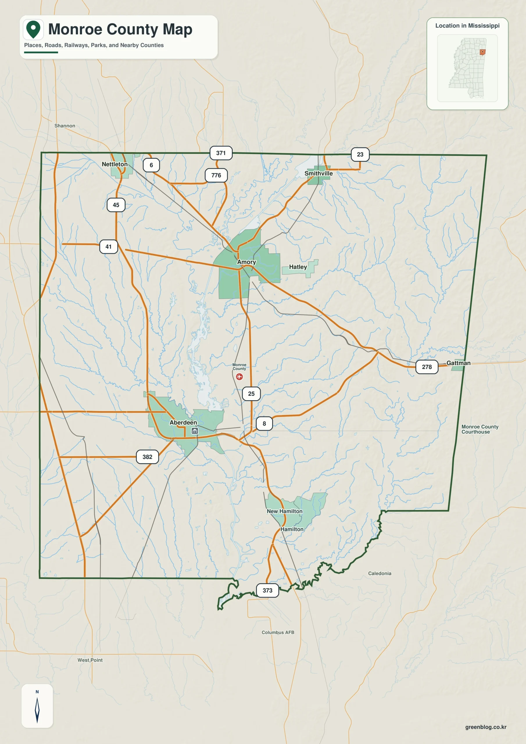
The Monroe County Mississippi map uses Aberdeen and Amory as two centers along the Tombigbee system, then places Nettleton, Smithville, and Hamilton across the north and east. The Tennessee-Tombigbee Waterway and Alabama line establish the main industrial, water, and boundary references in this large county.
Monroe County Mississippi map download
The WebP preview is optimized for the page, while the button preserves the original high-resolution JPG for printing and reuse.
- File: County reference map
- Format: JPG
- Print layout: A3
Quick Facts
- State and identifier: Mississippi, Monroe County; FIPS 28095
- County seat: Aberdeen
- Selected map labels: Aberdeen, Amory, Nettleton, Smithville, Hamilton
- 2020 census population: 34,180
- July 2025 population estimate: 33,318
- 2025 Gazetteer area: 765.128 sq mi land and 6.932 sq mi water
- 2020 land-area density: 44.7 residents per sq mi
- Primary route references: US 45, US 278, MS 25, and MS 6
- Landscape references: Tennessee-Tombigbee Waterway, Tombigbee River, Aberdeen Lake, Buttahatchee River, and Alabama line
The decennial count and July 2025 estimate use different reference dates. Land and water measurements come from the 2025 Gazetteer. The density of 44.7 residents per square mile divides the 2020 population by 2025 land area and does not imply an even distribution among cities, farms, forest, or wetland.
Reading the Monroe County Mississippi map
US 45 connects the Nettleton area in the northwest with Aberdeen and Lowndes County to the south. US 278 helps link Amory and Aberdeen, Smithville identifies the northeastern Itawamba County side, and Hamilton marks the eastern approach near Alabama. Waterway facilities and the complete rural-road network are omitted.
Boundary, Water, and Terrain
The Tombigbee River and Tenn-Tom Waterway run through the central county and include Aberdeen Lake. The Buttahatchee River enters the northeastern water system near Amory, while Alabama's Marion and Lamar counties meet the eastern edge. Western uplands and eastern river lowlands produce different road and settlement patterns.
Settlement and Regional Context
Aberdeen is the historic river and courthouse center, whereas Amory grew around railroad and manufacturing activity and remains a northern commercial center. Nettleton occupies a transport position near the Lee County line, and Smithville and Hamilton represent smaller rural community zones. A lower 2025 estimate adds context to the two-center settlement pattern.
Practical Map Uses
- Compare Aberdeen and Amory along the Tombigbee system
- Follow US 45 from Nettleton toward the southern boundary
- Use Hamilton to orient the Alabama state line
Frequently Asked Questions
Which city is the county seat, Aberdeen or Amory?
Aberdeen is the county seat. Amory is a major northern rail and commercial center, so both cities are necessary references with different roles.
Why compare Tennessee-Tombigbee Waterway with Aberdeen before reading the side toward Itawamba?
Aberdeen is a settlement anchor, while Tennessee-Tombigbee Waterway supplies a physical reference for separating the county interior from the approach to Itawamba.
Sources
- U.S. Census Bureau QuickFacts
- U.S. Census Bureau 2025 Gazetteer Files
- Mississippi Department of Transportation official highway map
- Regional landscape or institution reference
Related County Maps
Green Map creates custom-edited map images using open geographic data sources such as geoBoundaries, Natural Earth, OpenStreetMap, and government open data.
These maps are edited visual materials, not raw data files, and are provided for education, documents, presentations, and graphic reference.