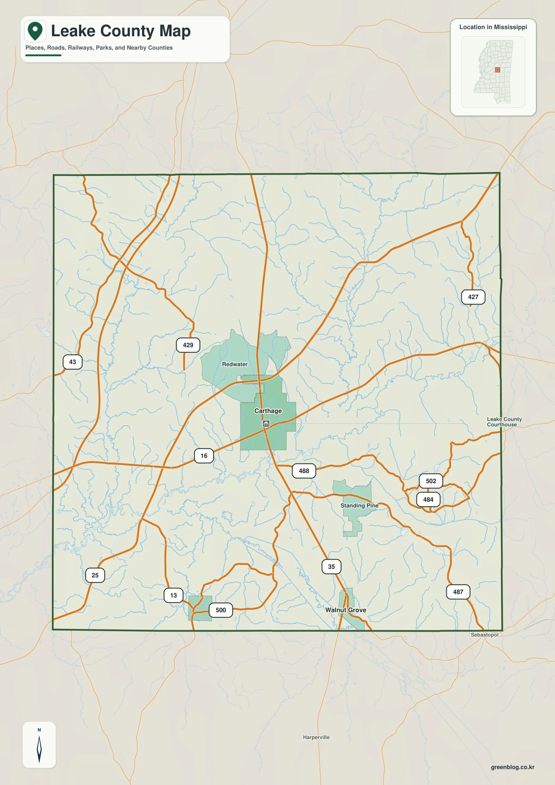
The Leake County Mississippi map radiates from Carthage toward Walnut Grove in the south, Sebastopol in the east, and Lena in the southwest. MS 16 and MS 35 intersect near the central service hub, while agricultural valleys, woods, and upper Pearl River drainage fill the broad rural county.
Leake County Mississippi map download
The WebP preview is optimized for the page, while the button preserves the original high-resolution JPG for printing and reuse.
- File: County reference map
- Format: JPG
- Print layout: A3
Quick Facts
- State and identifier: Mississippi, Leake County; FIPS 28079
- County seat: Carthage
- Selected map labels: Carthage, Walnut Grove, Sebastopol, Lena
- 2020 census population: 21,275
- July 2025 population estimate: 21,662
- 2025 Gazetteer area: 582.897 sq mi land and 2.462 sq mi water
- 2020 land-area density: 36.5 residents per sq mi
- Primary route references: MS 16, MS 25, MS 35, and MS 13
- Landscape references: upper Pearl River, Tuscolameta Creek, rolling central hills, and agricultural valleys
The decennial count and July 2025 estimate use different reference dates. Land and water measurements come from the 2025 Gazetteer. The density of 36.5 residents per square mile divides the 2020 population by 2025 land area and does not imply an even distribution among cities, farms, forest, or wetland.
Reading the Leake County Mississippi map
MS 16 leads east from Carthage toward Neshoba County and west toward Madison County. MS 35 links Walnut Grove in the south with the Attala County approach, Sebastopol identifies the Newton and Scott county side, and Lena provides a southwestern marker. The map selects major routes rather than every county road and small community.
Boundary, Water, and Terrain
Rolling central hills extend between Attala and Winston counties on the north and Scott County on the south. Upper Pearl River and Tuscolameta Creek drainage creates lower agricultural corridors, but no large reservoir dominates the outline. Roads cross multiple small watersheds between Neshoba and Newton counties in the east and Madison County in the west.
Settlement and Regional Context
Carthage concentrates courthouse, retail, health, and other local services. Walnut Grove and Sebastopol support separate southern and eastern community areas, and Lena anchors part of the southwest. Agriculture, poultry production, and forestry shape the land outside the towns. The 2025 estimate is slightly above the 2020 census count, indicating a relatively stable overall population.
Practical Map Uses
- Orient the MS 16 and MS 35 junction at Carthage
- Use Walnut Grove and Sebastopol to separate southern and eastern areas
- Place Lena relative to the Madison and Scott county approaches
Frequently Asked Questions
Is Carthage near the center of Leake County?
Carthage lies near the county's principal east-west and north-south highway junctions. Its administrative and service functions reinforce that central map position.
Why compare upper Pearl River with Carthage before reading the side toward Attala?
Carthage is a settlement anchor, while upper Pearl River supplies a physical reference for separating the county interior from the approach to Attala.
Sources
- U.S. Census Bureau QuickFacts
- U.S. Census Bureau 2025 Gazetteer Files
- Mississippi Department of Transportation official highway map
- Regional landscape or institution reference
Related County Maps
Green Map creates custom-edited map images using open geographic data sources such as geoBoundaries, Natural Earth, OpenStreetMap, and government open data.
These maps are edited visual materials, not raw data files, and are provided for education, documents, presentations, and graphic reference.