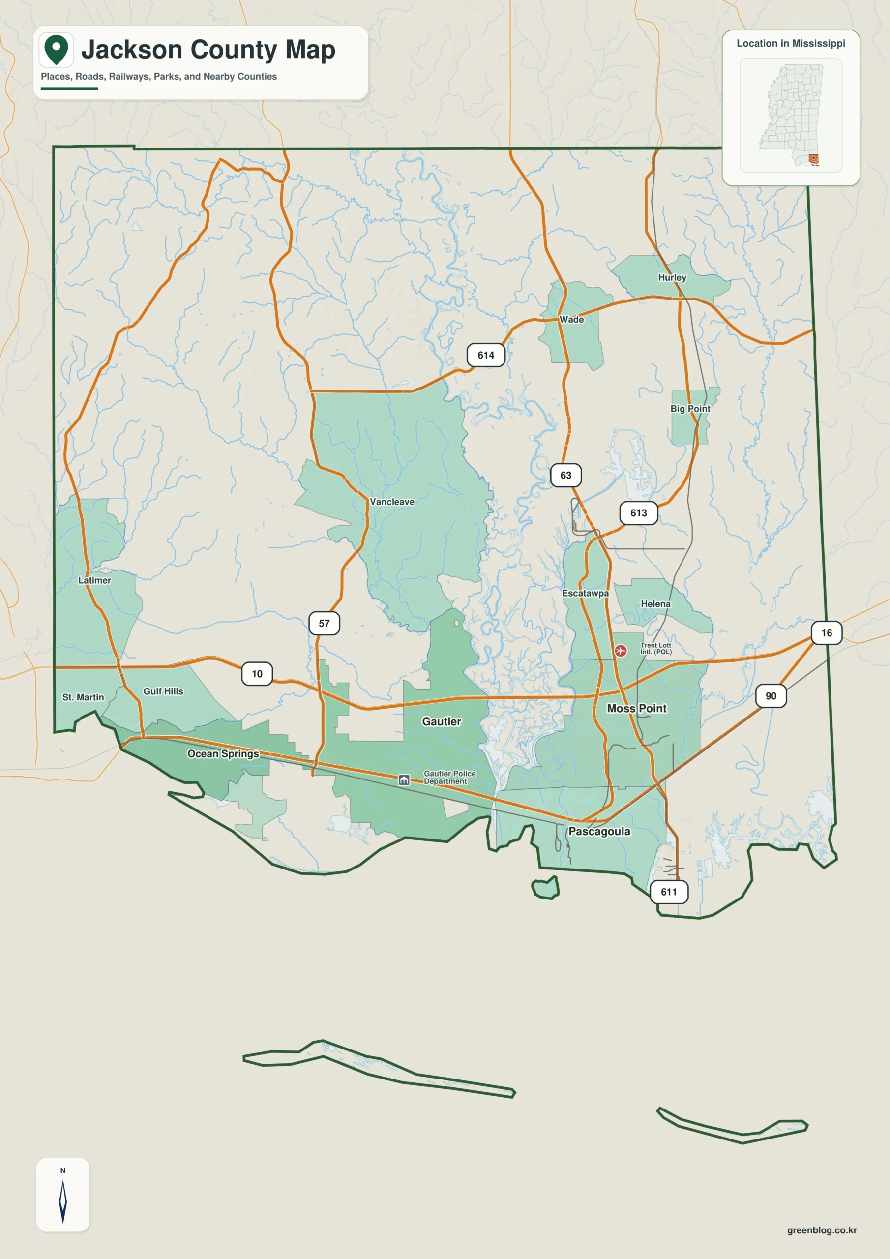
The Jackson County Mississippi map spans a complex Gulf Coast county rather than a single city cluster. Pascagoula and Moss Point anchor the eastern river-and-port area, Ocean Springs and Gautier organize the western coast, and Vancleave carries the view north into the wooded interior.
Jackson County Mississippi map download
The WebP preview is optimized for the page, while the button preserves the original high-resolution JPG for printing and reuse.
- File: County reference map
- Format: JPG
- Print layout: A3
Quick Facts
- State and identifier: Mississippi, Jackson County; FIPS 28059
- County seat: Pascagoula
- Selected map labels: Pascagoula, Ocean Springs, Gautier, Moss Point, Vancleave
- 2020 census population: 143,252
- July 2025 population estimate: 147,666
- 2025 Gazetteer area: 722.825 sq mi land and 320.578 sq mi water
- 2020 land-area density: 198.2 residents per sq mi
- Primary route references: I-10, US 90, MS 57, MS 63, and MS 613
- Landscape references: Pascagoula River, Escatawpa River, Mississippi Sound, coastal marsh, and barrier islands
The decennial count and July 2025 estimate use different reference dates. Land and water measurements come from the 2025 Gazetteer. The density of 198.2 residents per square mile divides the 2020 population by 2025 land area and does not imply an even distribution among cities, farms, forest, or wetland.
Reading the Jackson County Mississippi map
US 90 sequences Ocean Springs, Gautier, Pascagoula, and Moss Point from west to east. I-10 runs inland, and MS 57 links that corridor with Vancleave. Port property, marsh channels, neighborhood streets, and industrial-security boundaries require more detailed maps than this general county reference.
Boundary, Water, and Terrain
Harrison County lies west, Stone and George counties north, and Alabama's Mobile County east. The Pascagoula and Escatawpa rivers create an extensive estuary near the eastern coast. Mississippi Sound and offshore water add more than 320 square miles to the county's water area, while the dry-land county extends far north of the shore.
Settlement and Regional Context
Pascagoula's shipbuilding, port, and energy facilities make it the administrative and industrial center. Moss Point developed within the same river system but occupies a separate upstream position. Ocean Springs has a distinct residential and cultural identity beside Biloxi Bay, and Gautier has expanded between US 90 and I-10; Vancleave represents the rural inland county.
Practical Map Uses
- Sequence the US 90 coast from Ocean Springs to Moss Point
- Compare the Pascagoula estuary with the Alabama boundary
- Use Vancleave to show how far the county extends inland
Frequently Asked Questions
Why is the water area so large in Jackson County?
The boundary includes Mississippi Sound, estuaries, marsh channels, and offshore waters. Those areas are substantial even though most residents live on dry land near the highway corridors.
Why compare Pascagoula River with the spacing from Pascagoula to Ocean Springs and Harrison?
The interval from Pascagoula to Ocean Springs describes settlement spacing, while Pascagoula River and the Harrison side add physical and boundary evidence.
Sources
- U.S. Census Bureau QuickFacts
- U.S. Census Bureau 2025 Gazetteer Files
- Mississippi Department of Transportation official highway map
- Regional landscape or institution reference
Related County Maps
Green Map creates custom-edited map images using open geographic data sources such as geoBoundaries, Natural Earth, OpenStreetMap, and government open data.
These maps are edited visual materials, not raw data files, and are provided for education, documents, presentations, and graphic reference.