The Issaquena County Mississippi map is best read as a floodplain map rather than an urban one. Mayersville, Grace, Fitler, and Valley Park are small reference points between the Mississippi and Yazoo river systems in a county estimated at only 1,263 residents in 2025.
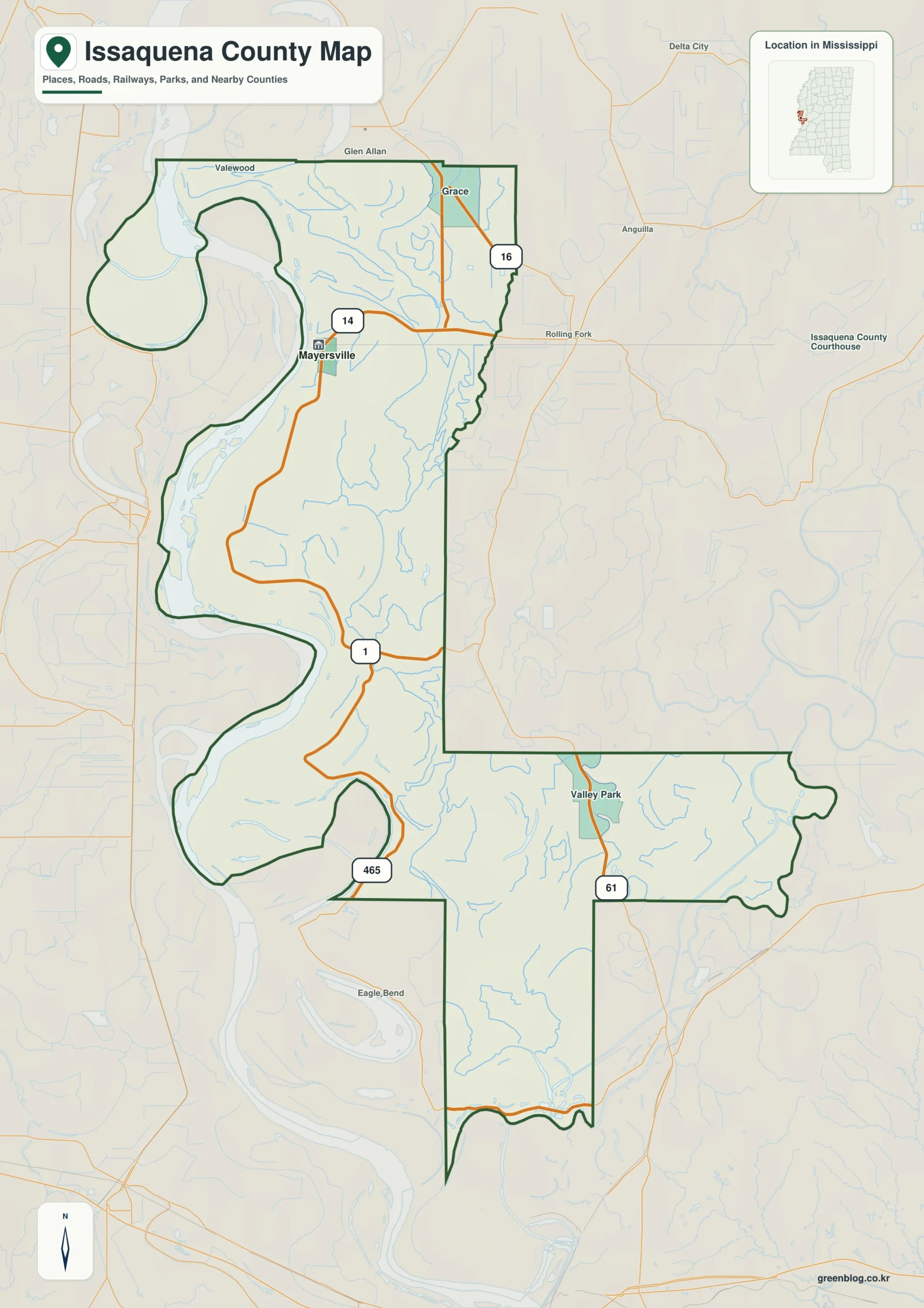
Issaquena County Mississippi map download
The WebP preview is optimized for the page, while the button preserves the original high-resolution JPG for printing and reuse.
- File: County reference map
- Format: JPG
- Print layout: A3
Quick Facts
- State and identifier: Mississippi, Issaquena County; FIPS 28055
- County seat: Mayersville
- Selected map labels: Mayersville, Grace, Fitler, Valley Park
- 2020 census population: 1,338
- July 2025 population estimate: 1,263
- 2025 Gazetteer area: 412.980 sq mi land and 28.442 sq mi water
- 2020 land-area density: 3.2 residents per sq mi
- Primary route references: US 61, MS 1, and MS 14
- Landscape references: Mississippi River, Yazoo River, Steele Bayou, levees, and bottomland forest
The decennial count and July 2025 estimate use different reference dates. Land and water measurements come from the 2025 Gazetteer. The density of 3.2 residents per square mile divides the 2020 population by 2025 land area and does not imply an even distribution among cities, farms, forest, or wetland.
Reading the Issaquena County Mississippi map
Mayersville identifies the northwestern administrative center near the Mississippi River levee, and Fitler marks a lower river position. Grace and Valley Park shift attention east toward US 61 and the Yazoo County side. Seasonal channels, field entrances, and individual levee roads are not represented at this scale.
Boundary, Water, and Terrain
Across the Mississippi River lie Arkansas and Louisiana jurisdictions; Washington County is north, while Warren County is south. Steele Bayou, the Yazoo system, and extensive bottomland divide an otherwise nearly level surface. The county covers more than 400 land square miles despite having fewer people than many city neighborhoods.
Settlement and Regional Context
Large farms, bottomland forest, wetlands, and wildlife habitat share the county's floodplain. Levees and drainage works determine where roads and settlements can persist, giving Mayersville an outsized administrative role. The selected labels are therefore less important as population centers than as anchors in a water-controlled landscape.
Practical Map Uses
- Separate Mayersville and Fitler along the Mississippi River side
- Compare US 61's eastern corridor with MS 1 near the levee
- Show how Arkansas and Louisiana meet Mississippi across the river
Frequently Asked Questions
Why is US 61 far from Mayersville on the county map?
US 61 follows the firmer eastern side of the county, while Mayersville sits west near the Mississippi River levee. Wetlands and flood-control geography separate the two corridors.
Which different map roles are served by Mayersville, Mississippi River, and the Washington side?
Mayersville works as a place anchor, Mississippi River as a landscape anchor, and Washington as an outer reference for reading three different layers of the county.
Sources
- U.S. Census Bureau QuickFacts
- U.S. Census Bureau 2025 Gazetteer Files
- Mississippi Department of Transportation official highway map
- Regional landscape or institution reference
Related County Maps
Green Map creates custom-edited map images using open geographic data sources such as geoBoundaries, Natural Earth, OpenStreetMap, and government open data.
These maps are edited visual materials, not raw data files, and are provided for education, documents, presentations, and graphic reference.