The George County Mississippi map centers on Lucedale while keeping the Alabama line, Escatawpa River, and Black Creek forest country in view. Agricola, Benndale, and Merrill provide separate eastern, western, and northern references across an inland Gulf region connected by US 98 and state highways.
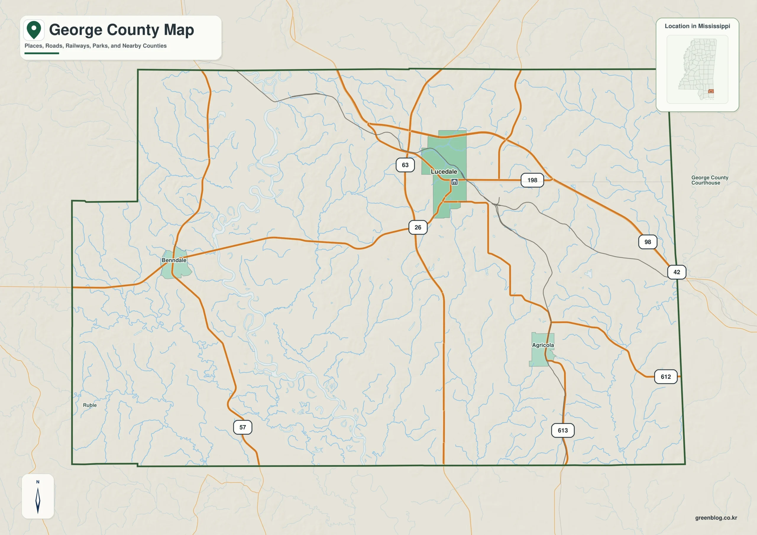
George County Mississippi map download
The WebP preview is optimized for the page, while the button preserves the original high-resolution JPG for printing and reuse.
- File: County reference map
- Format: JPG
- Print layout: A3
Quick Facts
- State and identifier: Mississippi, George County; FIPS 28039
- County seat: Lucedale
- Selected map labels: Lucedale, Agricola, Benndale, Merrill
- 2020 census population: 24,350
- July 2025 population estimate: 26,331
- 2025 Gazetteer area: 478.699 sq mi land and 4.954 sq mi water
- 2020 land-area density: 50.9 residents per sq mi
- Primary route references: US 98, MS 26, MS 57, and MS 63
- Landscape references: Escatawpa River, Black Creek, De Soto National Forest, and Alabama state line
The decennial count and the July 2025 estimate represent different reference dates. Land and water values come from the 2025 Gazetteer. The density of 50.9 residents per square mile uses the 2020 population and land area; it does not imply an even distribution among towns, farms, forests, or floodplain.
George County Mississippi map: What It Shows
Lucedale is the county seat and the principal junction of US 98 and MS 26. Agricola points east toward Alabama, Benndale marks the western approach, and Merrill identifies the northern forest interior. MS 57 and MS 63 organize movement south toward Jackson County and the broader Gulf Coast economy.
County Layout and Location
George occupies Mississippi’s southeastern interior and touches Mobile and Washington counties in Alabama. The Escatawpa River and Black Creek drain a pine-covered coastal plain that includes De Soto National Forest land. The straight state line and irregular waterways offer two very different ways to orient the county.
Local Context: Lucedale near the Alabama Line
Lucedale developed as a rail, timber, and agricultural service center. Connections to Mobile and the Mississippi Gulf Coast later broadened commuting and freight patterns, while extensive forest remains in the northern and western county. Recent population growth adds a suburbanizing edge to a landscape that is still largely rural.
Ways to Use This Map
- Orient travel between Lucedale and the Alabama line
- Compare US 98 with southbound Gulf Coast routes
- Relate forest communities to the Escatawpa and Black Creek watersheds
Frequently Asked Questions
Is Lucedale directly on the Alabama state line?
No. Lucedale lies west of the line within the eastern half of the county. Agricola supplies a closer reference for the Alabama approach.
Which different map roles are served by Lucedale, Escatawpa River, and the Greene side?
Lucedale works as a place anchor, Escatawpa River as a landscape anchor, and Greene as an outer reference for reading three different layers of the county.
Sources
- U.S. Census Bureau QuickFacts
- U.S. Census Bureau Gazetteer Files
- Mississippi Encyclopedia: George County
- Mississippi Department of Transportation official highway map
Related County Maps
Green Map creates custom-edited map images using open geographic data sources such as geoBoundaries, Natural Earth, OpenStreetMap, and government open data.
These maps are edited visual materials, not raw data files, and are provided for education, documents, presentations, and graphic reference.