The Franklin County Mississippi map connects the US 84 communities of Meadville, Bude, and Roxie with the much less settled Homochitto National Forest interior. Eddiceton and Lake Okhissa add eastern and recreational references, making the county’s large spaces between labels an essential part of the map.
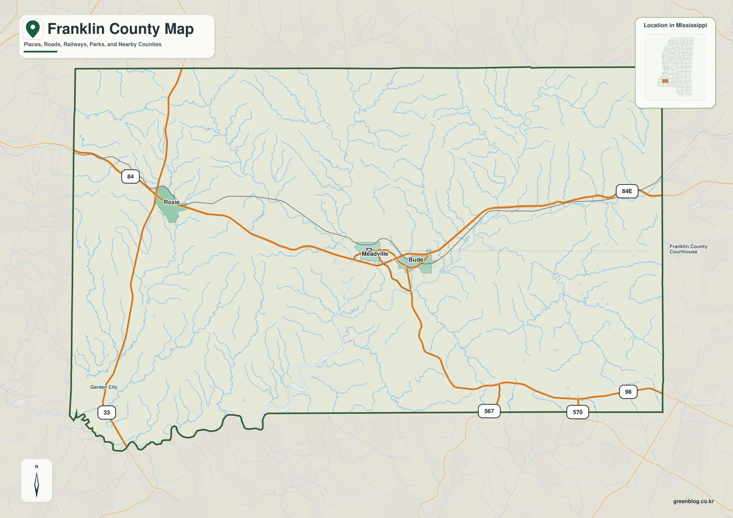
Franklin County Mississippi map download
The WebP preview is optimized for the page, while the button preserves the original high-resolution JPG for printing and reuse.
- File: County reference map
- Format: JPG
- Print layout: A3
Quick Facts
- State and identifier: Mississippi, Franklin County; FIPS 28037
- County seat: Meadville
- Selected map labels: Meadville, Bude, Roxie, Eddiceton
- 2020 census population: 7,675
- July 2025 population estimate: 7,491
- 2025 Gazetteer area: 563.964 sq mi land and 2.8 sq mi water
- 2020 land-area density: 13.6 residents per sq mi
- Primary route references: US 84, US 98, MS 33, and MS 556
- Landscape references: Homochitto National Forest, Homochitto River, Lake Okhissa, and southwest Mississippi hills
The decennial count and the July 2025 estimate represent different reference dates. Land and water values come from the 2025 Gazetteer. The density of 13.6 residents per square mile uses the 2020 population and land area; it does not imply an even distribution among towns, farms, forests, or floodplain.
Franklin County Mississippi map: What It Shows
Meadville sits near the middle of the US 84 line, with Bude to the east and Roxie to the west. Eddiceton marks the northeastern approach toward Lincoln County. Lake Okhissa lies south of the seat in national forest land, so it belongs to a recreation and watershed layer distinct from the town corridor.
County Layout and Location
Franklin’s 2020 density was only 13.6 residents per square mile. The Homochitto River and its tributaries cut through wooded hills, and large areas south and west of the highway towns contain no continuous urban fabric. Blank space on the county overview therefore reflects genuinely dispersed settlement.
Local Context: Homochitto Forest and Lake Okhissa
Homochitto National Forest combines timber management, conservation, and outdoor recreation, with Lake Okhissa as a prominent modern destination. Meadville and Bude supply civic and commercial services, yet forest ownership and long rural travel distances remain central to the county’s identity.
Ways to Use This Map
- Orient visitors to Lake Okhissa and nearby communities
- Explain the spacing of towns along US 84
- Relate national forest land to the Homochitto watershed
Frequently Asked Questions
Is Lake Okhissa inside Meadville?
No. The lake is south of Meadville within Homochitto National Forest. It should be treated as a separate recreation destination rather than a town feature.
Why is Meadville alone insufficient for interpreting Homochitto National Forest near Jefferson?
The Meadville label marks a human center, but Homochitto National Forest extends through a wider landscape whose relationship with Jefferson cannot be inferred from town labels alone.
Sources
- U.S. Census Bureau QuickFacts
- U.S. Census Bureau Gazetteer Files
- Mississippi Encyclopedia: Franklin County
- Mississippi Department of Transportation official highway map
Related County Maps
Green Map creates custom-edited map images using open geographic data sources such as geoBoundaries, Natural Earth, OpenStreetMap, and government open data.
These maps are edited visual materials, not raw data files, and are provided for education, documents, presentations, and graphic reference.