The Coahoma County Mississippi map places Clarksdale within a Delta landscape divided by the Mississippi River levee system and the Sunflower River. Friars Point, Jonestown, Lula, and Coahoma supply directional anchors across terrain where small elevation differences and drainage features matter more than visible hills.
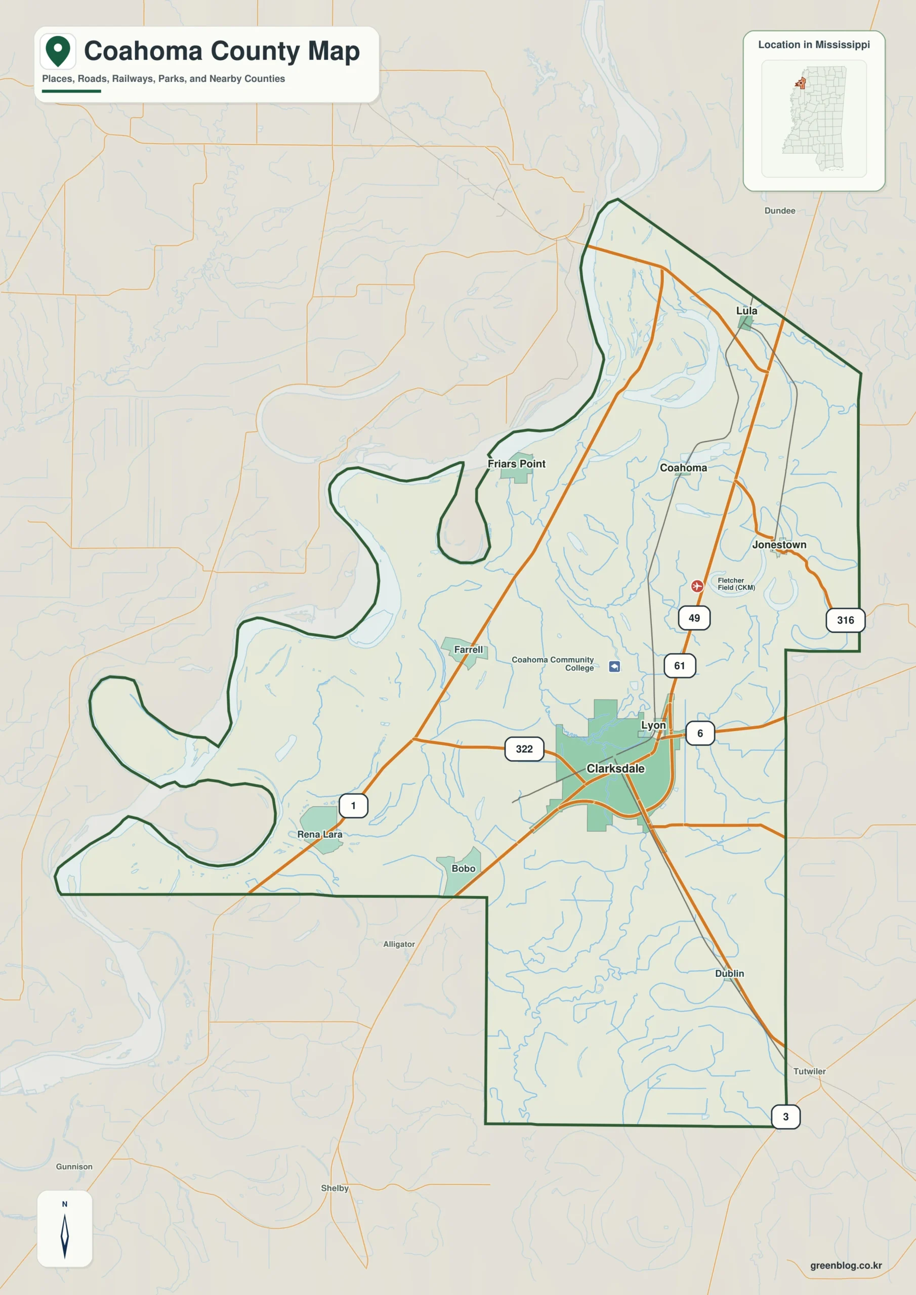
Coahoma County Mississippi map download
The WebP preview is optimized for the page, while the button preserves the original high-resolution JPG for printing and reuse.
- File: County reference map
- Format: JPG
- Print layout: A3
Quick Facts
- State and identifier: Mississippi, Coahoma County; FIPS 28027
- County seat: Clarksdale
- Selected map labels: Clarksdale, Friars Point, Jonestown, Lula, Coahoma
- 2020 census population: 21,390
- July 2025 population estimate: 19,849
- 2025 Gazetteer area: 553.102 sq mi land and 29.933 sq mi water
- 2020 land-area density: 38.7 residents per sq mi
- Primary route references: US 49, US 61, US 278, MS 1, and MS 6
- Landscape references: Mississippi River, Sunflower River, Delta floodplain, levees, and blues heritage
The decennial count and the July 2025 estimate represent different reference dates. Land and water values come from the 2025 Gazetteer. The density of 38.7 residents per square mile uses the 2020 population and land area; it does not imply an even distribution among towns, farms, forests, or floodplain.
Coahoma County Mississippi map: What It Shows
Clarksdale is the major road junction and county seat. Friars Point pulls the map toward the river and levee, Lula marks the northern tier, Jonestown anchors the northeast, and the town of Coahoma identifies the southern interior. MS 1 and MS 6 reveal different river-parallel and cross-Delta movement patterns.
County Layout and Location
The Mississippi River forms the Arkansas boundary, but the practical edge includes broad floodplain and levee infrastructure. Eastward, the Sunflower River and drainage channels divide intensively farmed land. With little relief to guide the eye, the parallel and crossing relationships among waterways, highways, and towns become the key spatial clues.
Local Context: Clarksdale and Delta Waterways
Clarksdale became a cotton, rail, and commercial center and is internationally associated with Delta blues. The county’s music history is inseparable from agricultural labor, migration, and the network of small river and plantation communities. A county map supplies the geographic frame for that story without replacing a detailed heritage-site guide.
Ways to Use This Map
- Provide geographic context for a Delta blues itinerary
- Compare levee-side settlements with the Sunflower corridor
- Orient a study of highways crossing the agricultural Delta
Frequently Asked Questions
Is Friars Point closer to the Mississippi River than Clarksdale?
Yes. Friars Point lies along the levee-side western area, while Clarksdale is farther inland at the main highway junction.
Why compare Mississippi River with the spacing from Clarksdale to Friars Point and Tunica?
The interval from Clarksdale to Friars Point describes settlement spacing, while Mississippi River and the Tunica side add physical and boundary evidence.
Sources
- U.S. Census Bureau QuickFacts
- U.S. Census Bureau Gazetteer Files
- Mississippi Encyclopedia: Coahoma County
- Mississippi Department of Transportation official highway map
Related County Maps
Green Map creates custom-edited map images using open geographic data sources such as geoBoundaries, Natural Earth, OpenStreetMap, and government open data.
These maps are edited visual materials, not raw data files, and are provided for education, documents, presentations, and graphic reference.