The Calhoun County Mississippi map is best read as a network of small towns rather than a single dominant center. Pittsboro is the county seat, but Bruce, Calhoun City, Derma, and Vardaman distribute population and services across the Skuna and Yalobusha river country.
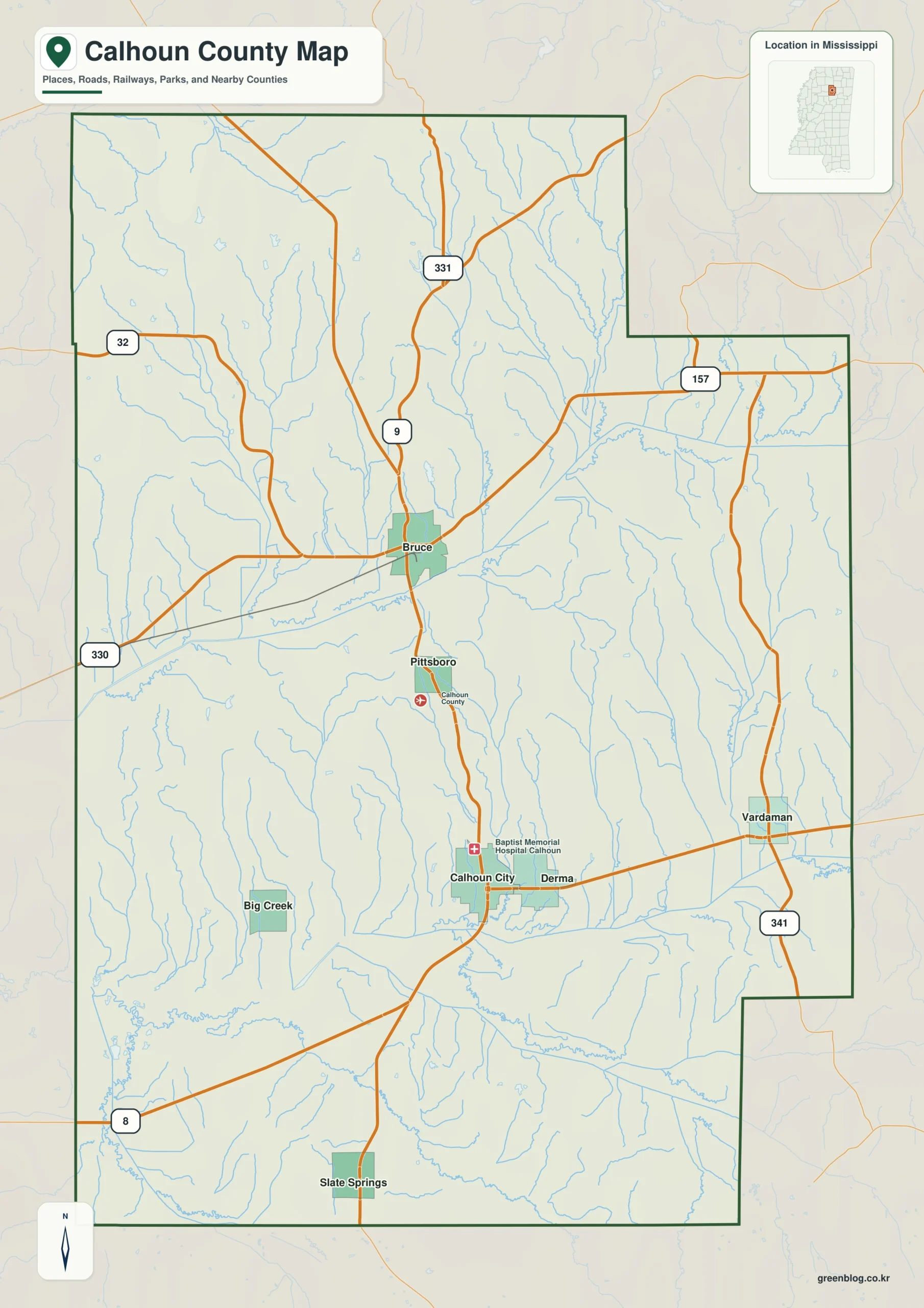
Calhoun County Mississippi map download
The WebP preview is optimized for the page, while the button preserves the original high-resolution JPG for printing and reuse.
- File: County reference map
- Format: JPG
- Print layout: A3
Quick Facts
- State and identifier: Mississippi, Calhoun County; FIPS 28013
- County seat: Pittsboro
- Selected map labels: Pittsboro, Bruce, Calhoun City, Derma, Vardaman
- 2020 census population: 13,266
- July 2025 population estimate: 12,643
- 2025 Gazetteer area: 586.573 sq mi land and 1.386 sq mi water
- 2020 land-area density: 22.6 residents per sq mi
- Primary route references: MS 8, MS 9, MS 32, and MS 330
- Landscape references: Skuna River, Yalobusha River basin, and north-central hill country
The decennial count and the July 2025 estimate represent different reference dates. Land and water values come from the 2025 Gazetteer. The density of 22.6 residents per square mile uses the 2020 population and land area; it does not imply an even distribution among towns, farms, forests, or floodplain.
Calhoun County Mississippi map: What It Shows
Pittsboro marks county government without dominating the settlement pattern. Bruce anchors the north; Calhoun City and Derma identify central and southern links; Vardaman points toward the eastern agricultural district. MS 8 and MS 9 offer the clearest first pass through this arrangement.
County Layout and Location
The Skuna River and tributaries of the Yalobusha basin divide a rolling landscape. Roads connect towns through valleys and higher ground rather than following a perfect grid. The map shows county-scale route relationships but omits many farm lanes, drainage structures, and local bridges.
Local Context: Vardaman and Skuna River Farms
Corn, timber, furniture production, and sweet-potato farming have all influenced Calhoun County. Vardaman’s marketing identity as a sweet-potato center gives the eastern side a distinctive role, while Pittsboro retains the county-seat function and Bruce serves the northern population cluster.
Ways to Use This Map
- Compare the county seat with Calhoun’s larger small-town centers
- Locate Vardaman within the sweet-potato growing district
- Relate the Skuna River basin to the state-route network
Frequently Asked Questions
Why does Pittsboro matter if it is not the largest town?
Pittsboro identifies county government. Bruce, Calhoun City, and Vardaman represent different population and economic roles, so the map distinguishes administration from everyday service centers.
How can Skuna River clarify the part of Calhoun County facing Lafayette?
Looking only at Pittsboro would reduce the map to town labels, whereas Skuna River explains the landscape transition toward Lafayette.
Sources
- U.S. Census Bureau QuickFacts
- U.S. Census Bureau Gazetteer Files
- Mississippi Encyclopedia: Calhoun County
- Mississippi Department of Transportation official highway map
Related County Maps
Green Map creates custom-edited map images using open geographic data sources such as geoBoundaries, Natural Earth, OpenStreetMap, and government open data.
These maps are edited visual materials, not raw data files, and are provided for education, documents, presentations, and graphic reference.