Macon County becomes much easier to understand once Tuskegee is treated as a starting point rather than the whole story. The county seat sits near the middle of a broad rural county, while Franklin and Shorter extend the westward view, Notasulga marks the northern side near Lee County, and a dense network of creeks cuts through rolling ground beyond the towns. This page separates those layers so you can study the county boundary, settlement pattern, waterways, and elevation without forcing every detail onto one crowded map.
The four map views are also available as downloadable files. The county map is best for roads and place names, the city map simplifies the relationship between Tuskegee and three nearby towns, the water map removes most road clutter so the drainage network stands out, and the elevation map shows where lower valleys give way to higher ridges. A single ZIP near the end of the article contains four high-resolution A3 JPG files for printing or offline reference.
Table of Contents
Start with Tuskegee, then follow the highways outward
Macon County lies in east-central Alabama between the Montgomery area and Auburn–Opelika. County sources place Elmore and Montgomery counties along the western side, Tallapoosa County to the north, Lee and Russell counties to the east, and Bullock County to the south. With about 608.7 square miles of land, the county is large enough that the pattern outside Tuskegee matters: long rural stretches, irregular boundary segments, and several different road approaches shape how the area is actually experienced.
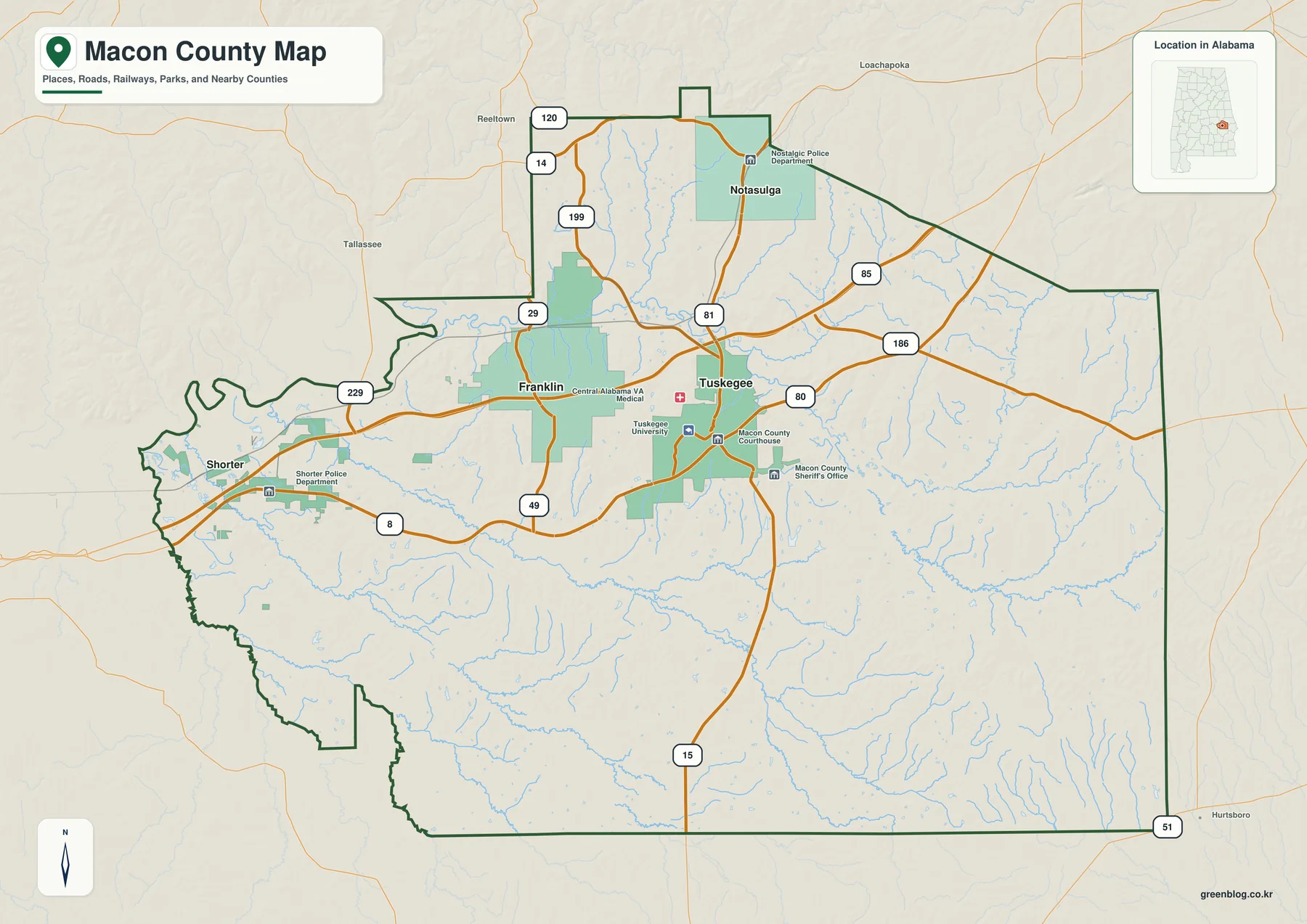
Tuskegee is the clearest anchor. The map labels Tuskegee University, the Macon County Courthouse, and other civic points close to the city, while several numbered routes converge around the same area. That concentration makes Tuskegee the practical reference point for government, education, and local orientation, but it does not sit on the county edge or function as the only gateway into Macon County.
I-85 crosses the northern part of the county and carries regional traffic between Montgomery and the Auburn–Opelika side of Alabama. U.S. 80 provides a direct connection toward Tuskegee, while U.S. 29 and state routes such as Alabama 14, 49, and 81 help explain movement between the smaller communities. The result is a road pattern in which the county seat is well connected but the strongest long-distance corridor passes north and west of the city center.
Franklin and Shorter are both west of Tuskegee on the supplied maps, but they should not be treated as the same location. Franklin is the closer western community, while Shorter is farther toward the Montgomery side and is especially useful for understanding the I-85 and U.S. 80 approach. To the north, Notasulga sits across the Macon–Lee county line, with most of the town in Macon County. Alabama 14 crosses the community and Alabama 81 runs south toward I-85, so the town naturally points toward both Tuskegee and the Auburn side of the region.
The county map is therefore most useful when you need context rather than a simple dot for the county seat. It shows which direction neighboring counties lie, which roads carry you toward the major regional centers, and how the labeled communities are distributed before you move on to the more specialized city, water, and elevation views.
The city-connection map changes the scale
The city map strips the picture back to four labeled communities and uses Tuskegee as the hub. That makes it easier to compare direction and separation without reading every highway shield or local point of interest. It is particularly helpful on a phone or in a printed worksheet where the full county map may contain more detail than the task requires.
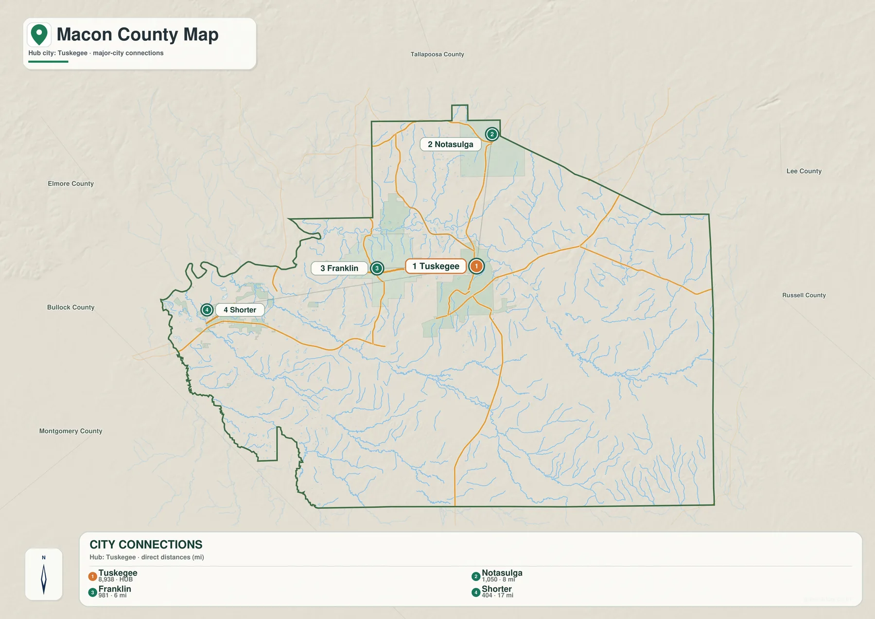
The distance labels are important to interpret correctly. Franklin is shown about 6 miles from Tuskegee, Notasulga about 8 miles, and Shorter about 17 miles. Those numbers are straight-line distances between the mapped points, not driving mileage. A road route can be longer because it follows the available highway network, curves around terrain, or begins and ends at different addresses within each town.
Direction tells as much as distance. Franklin appears just west of Tuskegee, while Shorter is farther west toward the Montgomery approach. Notasulga is north of Tuskegee, close to the Lee County side. The three places therefore give the county a simple west–north frame around its main city: two points help explain access toward Montgomery, and one helps explain the transition toward Auburn and Lee County.
This simplified view should not be read as a ranking of communities or as a current population chart. Its job is spatial orientation. When you need to identify a highway, courthouse, park, or county line, return to the county map; when you only need to explain where the named towns sit relative to Tuskegee, the city map is the cleaner choice.
Waterways are easier to see without the road layer
Macon County has far more visible drainage than the major-road map suggests. The water map emphasizes rivers, creeks, branches, ponds, and small lakes while keeping the county outline and light terrain underneath. The Tallapoosa River is the most prominent named river on the western and northwestern side, but the interior is divided by many smaller channels that give the county a much finer texture.
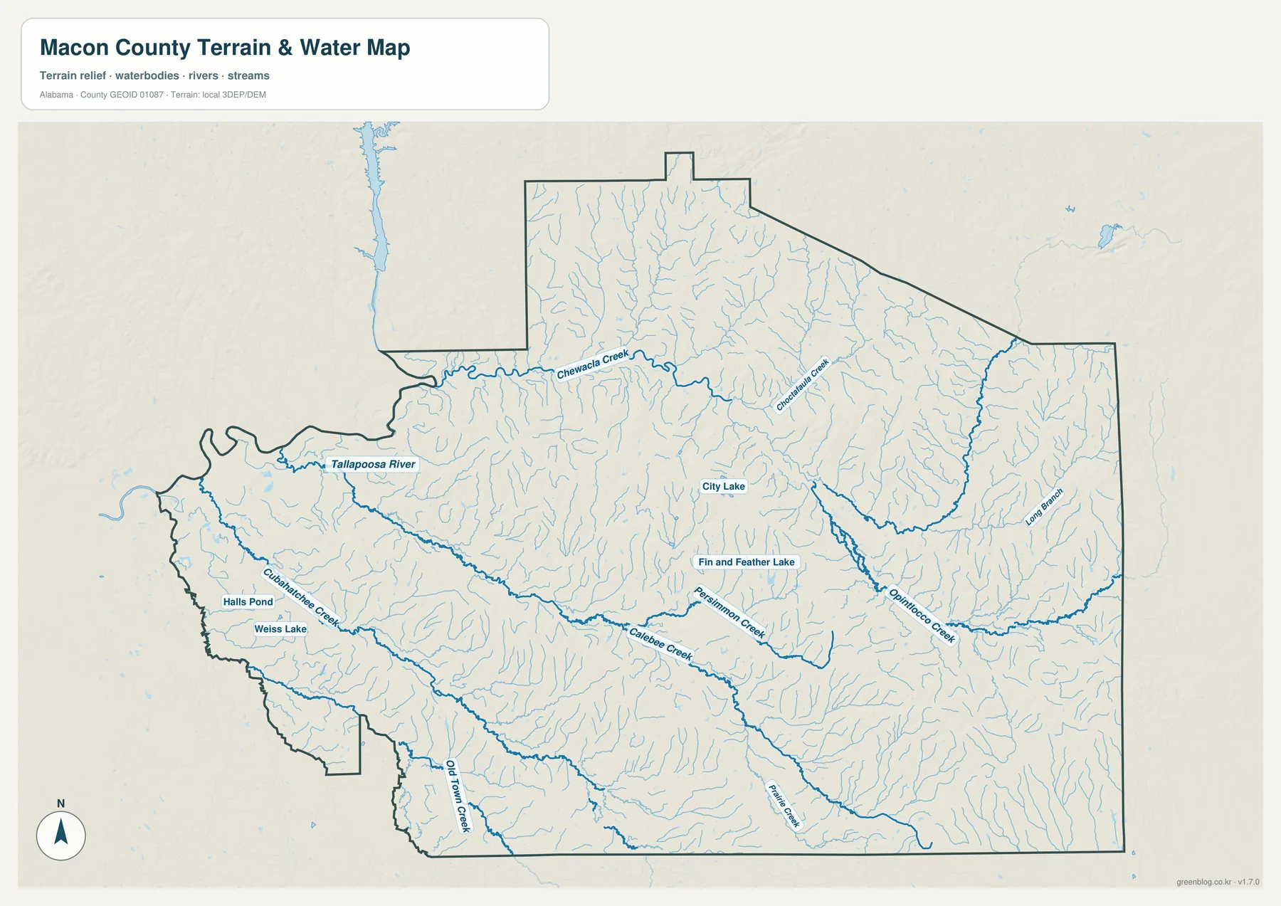
Chewacla Creek is easy to follow across the northern part of the county. On the western side, Cubahatchee Creek joins the dense stream network near the Tallapoosa side, while Calebee Creek cuts across the central and southern portion. Farther east, Persimmon Creek and Opintlocco Creek stand out among many unnamed tributaries, and Long Branch provides another labeled reference near the eastern edge. The exact purpose is not to memorize every stream name but to see how thoroughly the county is broken into small valleys.
The map also labels City Lake, Fin and Feather Lake, Weiss Lake, and Halls Pond. These smaller water bodies are useful local reference points because they show where water collects away from the main river and creek channels. When the water layer is compared with the city map, it becomes clear that most of the county outside the named towns is not empty space; it is a landscape of short drainage lines, wooded bottoms, farms, and local roads fitted between them.
This is a water-reference map, not a flood-risk or navigation product. It does not show flood zones, expected water depth, discharge, legal shoreline boundaries, or whether a channel is navigable. Use it to locate and compare water features. For property decisions, flood insurance, engineering, or emergency planning, consult the official source created for that specific purpose.
Elevation separates the low western corridors from the higher ridges
The elevation map adds a layer that road and water labels cannot provide on their own. It uses a locally scaled color range and shaded relief so changes in height are visible across the entire county. Green represents lower ground, while tan and brown move toward higher ground. Because the scale is adjusted to Macon County itself, subtle local differences remain visible even though the county does not contain high mountains.
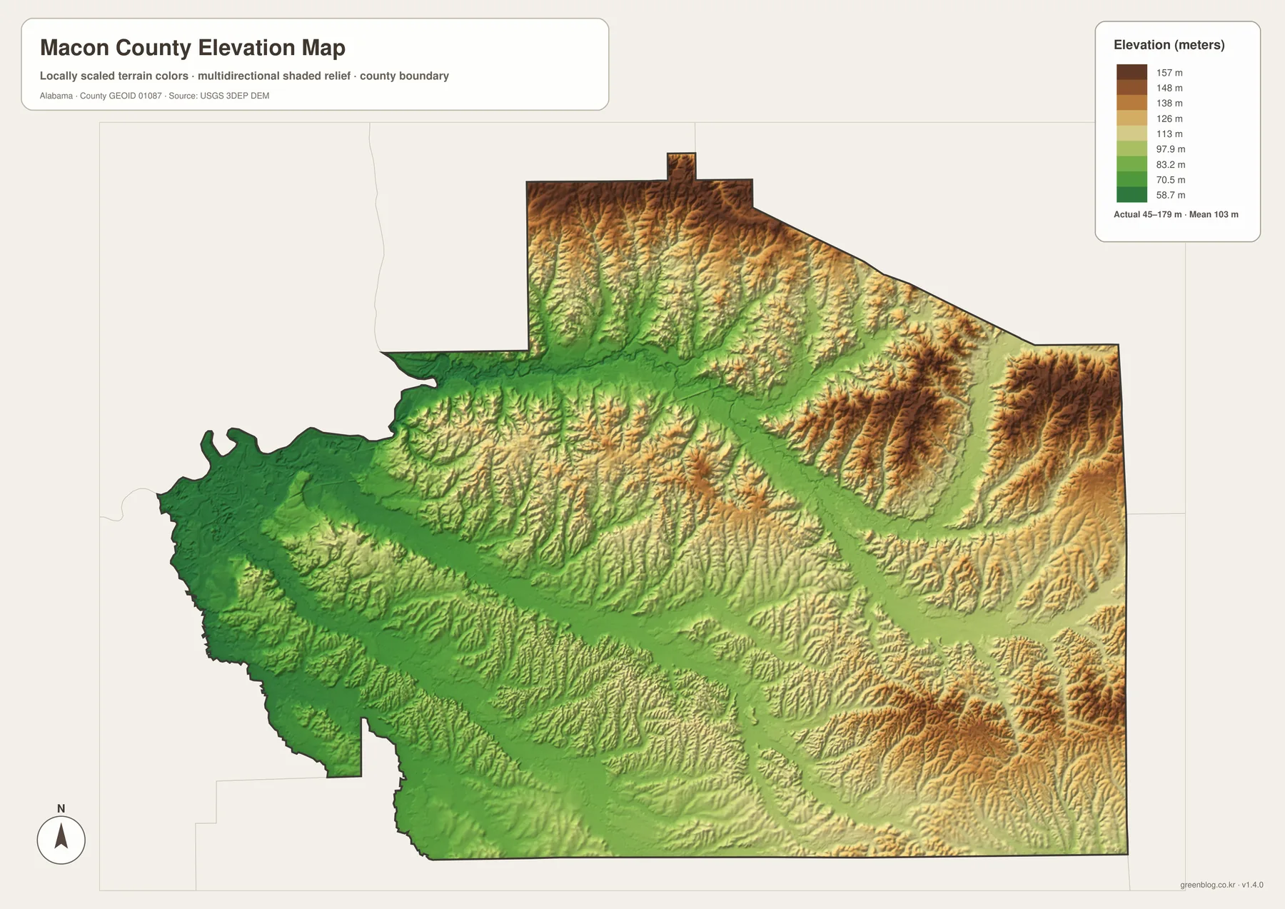
The legend reports an actual elevation range of about 45 to 179 meters, with a mean near 103 meters. Much of the western and southwestern side appears in lower green tones. Higher ridges become more common in the north, northeast, and east, where brown bands and closely spaced relief patterns stand out. Tuskegee lies in a mixed zone rather than on a single broad flat plain, which helps explain why nearby roads and streams repeatedly curve through low corridors between ridges.
A useful comparison is to place the water map beside the elevation map. Several broad green corridors on the relief view align with the valleys traced by named creeks on the water view. The higher ground sits between those channels, producing a repeating ridge-and-valley pattern that is difficult to see on the normal road map. This side-by-side reading gives a plain explanation for the county’s rolling appearance without requiring specialized GIS terminology.
The map is still a generalized county-scale surface. It is suitable for comparing lower and higher parts of Macon County, but it is not a survey, construction plan, or parcel-level elevation certificate. The colors are optimized for local contrast, so the same shade on a different county map would not necessarily represent the same height. For precise elevations, use the underlying USGS 3DEP data or a professional survey.
Tuskegee gives the county an unusually strong historical center
The maps explain where places sit, but Tuskegee also explains why Macon County is known far beyond east-central Alabama. Macon County was created in 1832 from territory ceded by the Creek Nation, and Tuskegee became its first and continuing county seat. The modern county is rural outside a few incorporated communities, yet the concentration of nationally significant educational and historic sites around Tuskegee gives the center of the map a much larger cultural role than its size alone would suggest.
Tuskegee University began in 1881 and became closely associated with Booker T. Washington and George Washington Carver. Their work in education, agriculture, research, and community outreach shaped the institution and the surrounding city. On a county map, that history helps explain why Tuskegee remains the obvious reference point even though regional highways such as I-85 pass outside the city core.
Two National Park Service units add another layer. Tuskegee Institute National Historic Site is centered on the historic university campus, including The Oaks, Booker T. Washington’s home, and the George Washington Carver Museum. Tuskegee Airmen National Historic Site is a separate place at Moton Field and interprets the World War II flight-training story associated with the Tuskegee Airmen. Visitors planning both sites should not assume that the similar names refer to one entrance or one group of buildings.
The rural side of the county is just as important to the map. Tuskegee National Forest lies near the Notasulga side of Macon County and provides a large forested landscape beyond the city. Franklin and Shorter supply western reference points, while the long network of creeks and the higher eastern ridges show why settlement remains dispersed outside Tuskegee. Taken together, the maps present Macon County as a county of one strong institutional center surrounded by smaller towns, highways, forests, valleys, and broad rural land.
Choose the map that matches the question
There is no single best version for every use. The most efficient approach is to start with the layer that answers your immediate question and add another only when you need more context. This keeps labels readable and avoids turning a simple location task into a crowded map-reading exercise.
- County map: use it for the county outline, Tuskegee, Franklin, Shorter, Notasulga, major highways, nearby counties, and selected civic landmarks.
- City map: use it when the main task is comparing the direction and straight-line separation of the three smaller towns from Tuskegee.
- Water map: use it to trace the Tallapoosa River side, named creeks, small lakes, ponds, and the dense tributary network without heavy road labeling.
- Elevation map: use it to compare low western valleys with higher northern and eastern ridges and to see how relief relates to the drainage pattern.
For a classroom handout, the county map usually makes the best first page because it combines places and roads. A natural-resources lesson can pair the water and elevation maps, while a local-history presentation can use the city map to orient Tuskegee, Franklin, Shorter, and Notasulga before discussing individual sites. If you are planning an actual drive, use these maps for orientation and then check a current navigation service for turn-by-turn routing and travel time.
The downloadable archive is designed for larger use than the WebP previews embedded in the article. It contains four original A3 high-resolution JPG files, one for each map type. Keeping the files separate means you can print only the layer you need, place two maps side by side in a presentation, or zoom in on labels without mixing every category of information together.
Frequently Asked Questions
What is the county seat of Macon County, Alabama?
Tuskegee is the county seat. It is also the main institutional center on the maps, with county government, Tuskegee University, and nationally significant historic sites concentrated in and around the city.
Are the 6-, 8-, and 17-mile numbers on the city map driving distances?
No. They are straight-line distances from the Tuskegee hub to the mapped points for Franklin, Notasulga, and Shorter. Actual road mileage depends on the route and on the exact starting and ending addresses, so the numbers should be used for relative location rather than turn-by-turn travel planning.
Can the water map be used as a flood map?
No. The water map shows the location of rivers, creeks, branches, lakes, and ponds, but it does not contain flood zones, expected depths, or insurance information. Use official flood-hazard data when the question involves property risk or emergency planning.
Is the elevation map accurate enough for surveying or construction?
It is a county-scale terrain reference, not a survey product. The relief is based on elevation data and is useful for comparing higher and lower parts of Macon County, but engineering, grading, or property work requires the original elevation data and, where appropriate, professional field measurements.
Map File Information
Macon County A3 map files
- File Type: four high-resolution A3 JPG files
Related Maps
- Abbeville, Headland, and Lake Eufaula on the Henry County Alabama Map
- Athens to Wheeler Reservoir on the Limestone County Alabama Map
- Autauga County Map
Sources and reference data
These authoritative and county-specific resources are useful for checking roads, water features, elevation data, and the local history described with the maps.
- ALDOT Highway Functional Classification Maps
- USGS National Hydrography
- USGS 3D Elevation Program
- Encyclopedia of Alabama: Macon County
- National Park Service: Tuskegee Institute National Historic Site
- National Park Service: Tuskegee Airmen National Historic Site
- USDA Forest Service: Tuskegee National Forest
Green Map creates custom-edited map images using open geographic data sources such as geoBoundaries, Natural Earth, OpenStreetMap, and government open data. These maps are edited visual materials, not raw data files, and are provided for education, documents, presentations, and graphic reference.