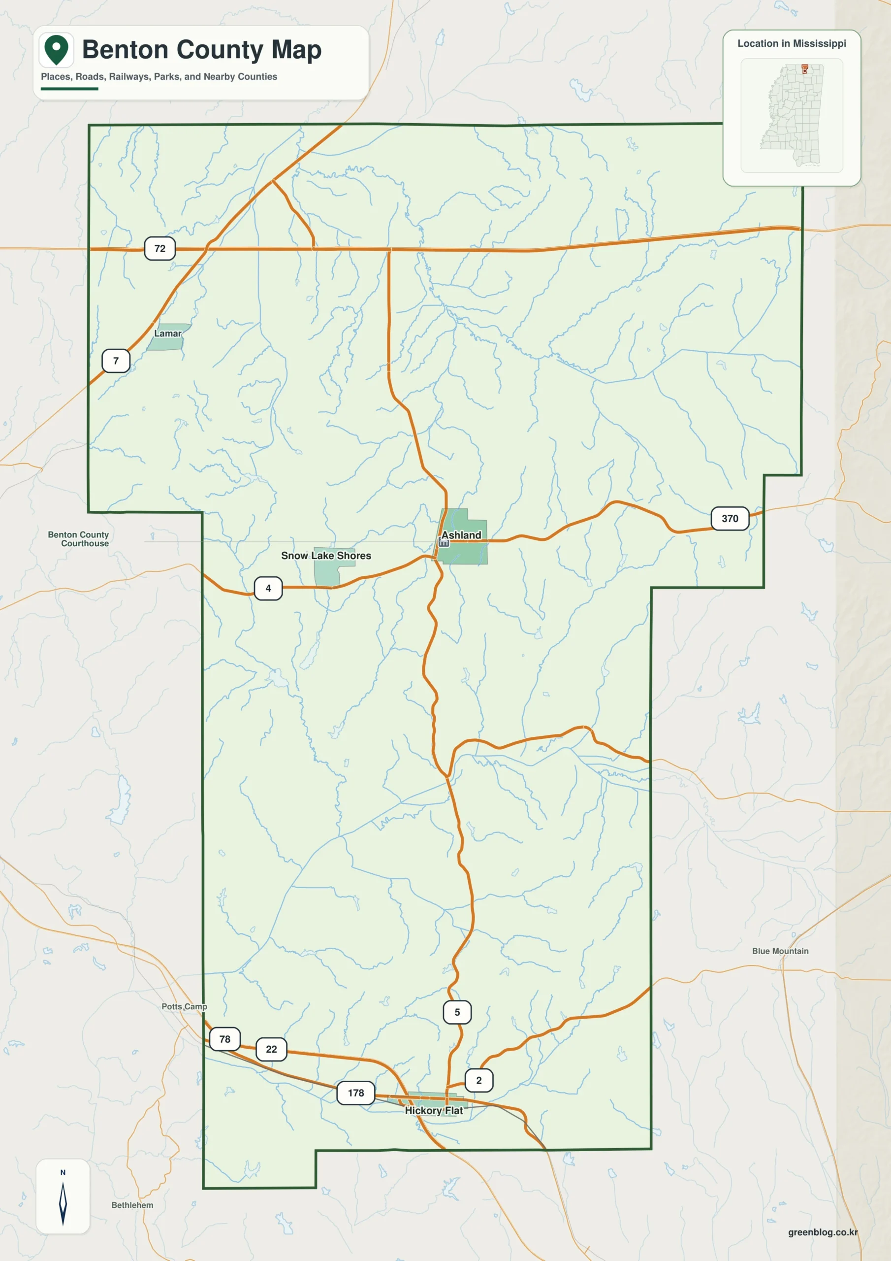
The Benton County Mississippi map separates two useful frames: Ashland near the county’s administrative center and the US 72 corridor along the southern tier. Hickory Flat, Snow Lake Shores, and Lamar add orientation across a sparsely populated border county.
Benton County Mississippi map download
The WebP preview is optimized for the page, while the button preserves the original high-resolution JPG for printing and reuse.
- File: County reference map
- Format: JPG
- Print layout: A3
Quick Facts
- State and identifier: Mississippi, Benton County; FIPS 28009
- County seat: Ashland
- Selected map labels: Ashland, Hickory Flat, Snow Lake Shores, Lamar
- 2020 census population: 7,646
- July 2025 population estimate: 7,502
- 2025 Gazetteer area: 406.616 sq mi land and 2.038 sq mi water
- 2020 land-area density: 18.8 residents per sq mi
- Primary route references: US 72, MS 5, MS 7, and MS 178
- Landscape references: Tennessee state line, Wolf River headwaters, and north-central uplands
The decennial count and the July 2025 estimate represent different reference dates. Land and water values come from the 2025 Gazetteer. The density of 18.8 residents per square mile uses the 2020 population and land area; it does not imply an even distribution among towns, farms, forests, or floodplain.
Benton County Mississippi map: What It Shows
Ashland identifies county government, while Hickory Flat and Lamar pull attention toward the southern travel corridor. Snow Lake Shores represents a different lake-oriented settlement pattern. The distinction matters because the administrative center and the busiest cross-county route are not located in the same place.
County Layout and Location
Tennessee forms the northern edge, with Mississippi’s Lafayette and Union counties to the south. Headwaters of the Wolf River and rolling uplands break up the rural landscape. A 2020 density of 18.8 residents per square mile explains why the map has broad spaces between named places.
Local Context: Ashland and Tennessee Uplands
Benton County was organized in 1870 from parts of Marshall and Tippah counties on former Chickasaw land. It was among the early Mississippi counties to receive Tennessee Valley Authority electricity, a historical connection that complements its present border position and rural settlement pattern.
Ways to Use This Map
- Distinguish the county seat from the southern highway corridor
- Orient a Tennessee–Mississippi border comparison
- Show why rural labels are widely spaced in Benton County
Frequently Asked Questions
Why is Ashland separate from the US 72 corridor?
County government is based inland at Ashland, while US 72 crosses the southern part of Benton County. The map makes that administrative-versus-transport distinction visible.
What geographic context does Tennessee state line provide from Ashland toward Marshall?
From Ashland, Tennessee state line supplies a terrain or water cue for tracking the county toward Marshall; precise access still belongs to a specialized map.
Sources
- U.S. Census Bureau QuickFacts
- U.S. Census Bureau Gazetteer Files
- Mississippi Encyclopedia: Benton County
- Mississippi Department of Transportation official highway map
Related County Maps
Green Map creates custom-edited map images using open geographic data sources such as geoBoundaries, Natural Earth, OpenStreetMap, and government open data.
These maps are edited visual materials, not raw data files, and are provided for education, documents, presentations, and graphic reference.