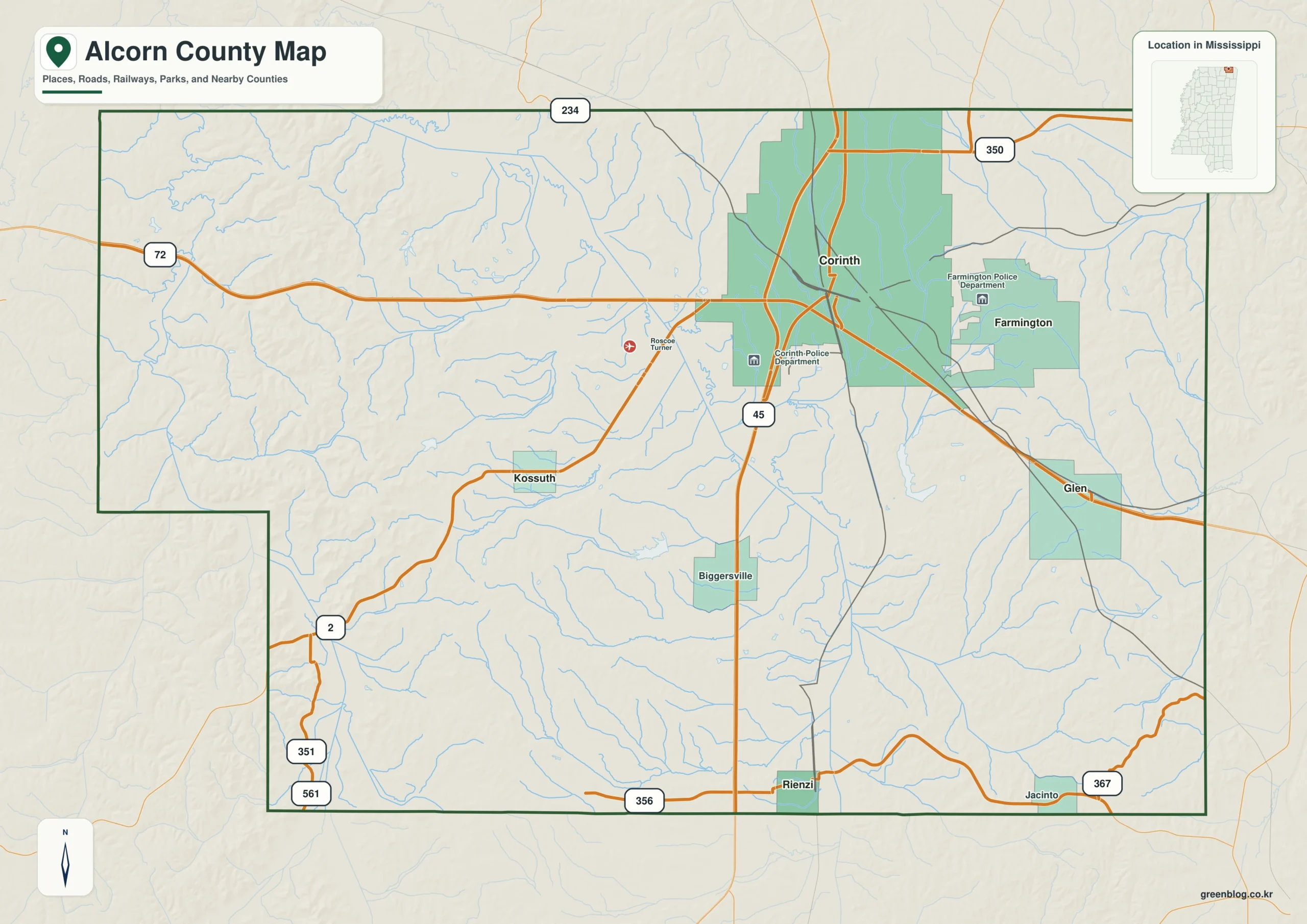
The Alcorn County Mississippi map places Corinth at the meeting point of major road and rail corridors near the Tennessee line. Farmington, Glen, Kossuth, and Rienzi extend the reference beyond the county seat, making the map useful for understanding both border access and the county’s compact settlement pattern.
Alcorn County Mississippi map download
The WebP preview is optimized for the page, while the button preserves the original high-resolution JPG for printing and reuse.
- File: County reference map
- Format: JPG
- Print layout: A3
Quick Facts
- State and identifier: Mississippi, Alcorn County; FIPS 28003
- County seat: Corinth
- Selected map labels: Corinth, Farmington, Glen, Kossuth, Rienzi
- 2020 census population: 34,740
- July 2025 population estimate: 34,569
- 2025 Gazetteer area: 400.047 sq mi land and 1.314 sq mi water
- 2020 land-area density: 86.8 residents per sq mi
- Primary route references: US 45, US 72, MS 2, and MS 145
- Landscape references: Tennessee state line, rolling northeastern uplands, and the historic rail junction at Corinth
The decennial count and the July 2025 estimate represent different reference dates. Land and water values come from the 2025 Gazetteer. The density of 86.8 residents per square mile uses the 2020 population and land area; it does not imply an even distribution among towns, farms, forests, or floodplain.
Alcorn County Mississippi map: What It Shows
Begin at Corinth, then follow US 72 west–east and US 45 north–south. Farmington marks the border-side approach, Rienzi pulls the eye south, Kossuth identifies the western interior, and Glen gives a southeastern reference. Smaller local roads and every unincorporated place are intentionally outside the scope of this county overview.
County Layout and Location
Alcorn is a compact county at Mississippi’s northeastern edge. The Tennessee boundary shortens the distance between Corinth and communities in another state, while the US 45–US 72 crossing connects north–south and east–west travel. Rolling uplands shape local alignments, though the map does not portray street-level grades.
Local Context: Corinth Rail Crossroads
Corinth’s rise as a railroad center in the 1850s made it strategically important during the Civil War. The modern highway pattern reinforces the same crossroads logic: regional movement remains concentrated near the county seat rather than evenly distributed across the county.
Ways to Use This Map
- Support a Corinth rail or Civil War location overview
- Compare Tennessee-border access with the US 45 and US 72 corridors
- Show how smaller communities surround the county’s principal hub
Frequently Asked Questions
How do Farmington and Rienzi help orient the Alcorn County map?
Farmington pulls the view toward the Tennessee line, whereas Rienzi marks the southern interior. Their separation gives a clearer north–south scale than Corinth alone.
How does Tennessee state line complement Corinth when orienting the map toward Hardin?
A symbol at Corinth fixes one named point; Tennessee state line adds a broader frame that can be followed toward Hardin without treating every local road as mapped.
Sources
- U.S. Census Bureau QuickFacts
- U.S. Census Bureau Gazetteer Files
- Mississippi Encyclopedia: Alcorn County
- Mississippi Department of Transportation official highway map
Related County Maps
Green Map creates custom-edited map images using open geographic data sources such as geoBoundaries, Natural Earth, OpenStreetMap, and government open data.
These maps are edited visual materials, not raw data files, and are provided for education, documents, presentations, and graphic reference.