This Kosovo map collection presents the country’s current municipal structure in three practical styles: a labeled black and white version, a color-coded version, and a clean outline version. Each design shows the same set of 38 municipalities, allowing readers to move between reference, presentation, and activity formats without changing the underlying administrative layout.
Kosovo is a landlocked territory in the central Balkans. Montenegro lies to the northwest, Albania to the west and southwest, North Macedonia to the south, and Serbia to the north and east. These neighboring countries appear outside the national boundary so that the location is easy to understand, but they remain visually separate from Kosovo’s municipal areas.
The files are arranged for A3 output and can be reduced for smaller paper sizes when needed. This printable Kosovo map set is useful for geography lessons, reports, travel-planning notes, regional comparisons, presentation slides, and infographic projects. The three versions also make it possible to choose between a ready-to-read map and a simpler base for custom labels or color schemes.
Table of Contents
Kosovo map overview: 38 municipalities and one exclave
Kosovo is divided into 38 municipalities. Pristina is the capital and the main urban center, while Prizren, Peja, Gjakova, Mitrovica, and Gjilan are other important regional centers. The northern group includes Leposavić, Zubin Potok, Zvečan, and North Mitrovica, which are shown as separate municipal units rather than merged into one region.
The central Kosovo map also includes the small Shashkoc area, often written Šaškovac in Serbian-language sources. It is an approximately 2.8-square-kilometer exclave belonging to Pristina Municipality and is surrounded by territory associated with Gračanica and Lipjan. Because of its position, this small shape may look like a detached island inside another municipality. It should use the same fill color as Pristina, not the color assigned to Gračanica.
Municipal names included
The map labels the following municipalities. Spellings can vary between English, Albanian, and Serbian sources, so the artwork uses a consistent set of familiar Latin-script forms.
| Region of the map | Municipalities shown |
|---|---|
| North and northwest | Leposavić, Zubin Potok, Zvečan, North Mitrovica, Mitrovica, Vushtrri, Skenderaj, Istog |
| West | Peja, Klina, Deçan, Junik, Gjakova |
| Center | Drenas, Obiliq, Fushë Kosovë, Pristina, Gračanica, Lipjan, Malisheva |
| East | Podujevë, Kamenica, Novo Brdo, Ranilug, Gjilan |
| South and southwest | Rahovec, Suharekë, Prizren, Mamuşa, Dragash, Shtime, Ferizaj, Štrpce |
| Southeast | Kaçanik, Hani i Elezit, Viti, Klokot, Parteš |
Black and white labeled version
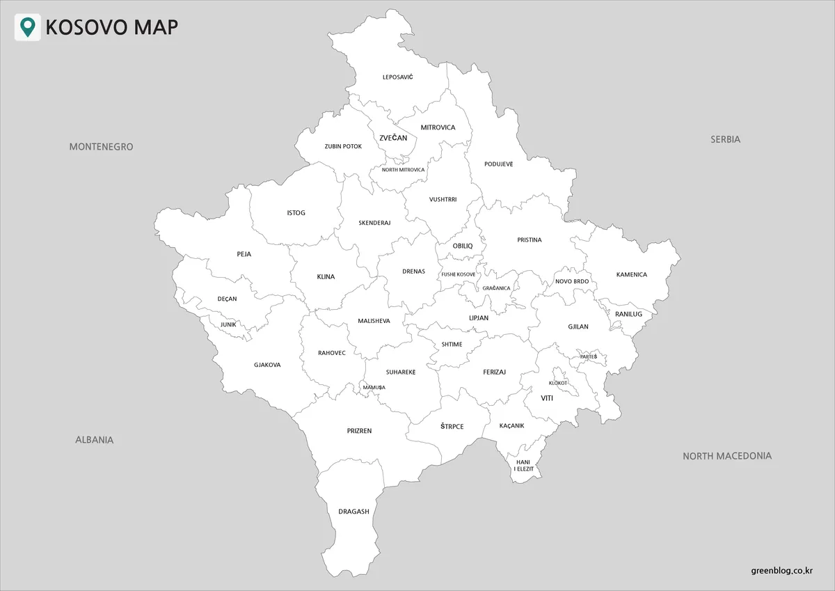
The black and white Kosovo map is the clearest choice when place names must remain easy to read. Municipal interiors stay white, administrative boundaries use thin gray lines, and neighboring countries sit on a light-gray background. This restrained contrast works well in documents, school handouts, monochrome printing, and reference pages where labels are more important than decorative color.
Small municipalities around Pristina and Gjilan require careful viewing because several boundaries are close together. The labeled version retains these divisions, including Fushë Kosovë, Obiliq, Gračanica, Novo Brdo, Klokot, Parteš, and Ranilug. It also preserves Shashkoc as part of Pristina even though the exclave is physically detached from Pristina’s main polygon.
Color-coded municipality version
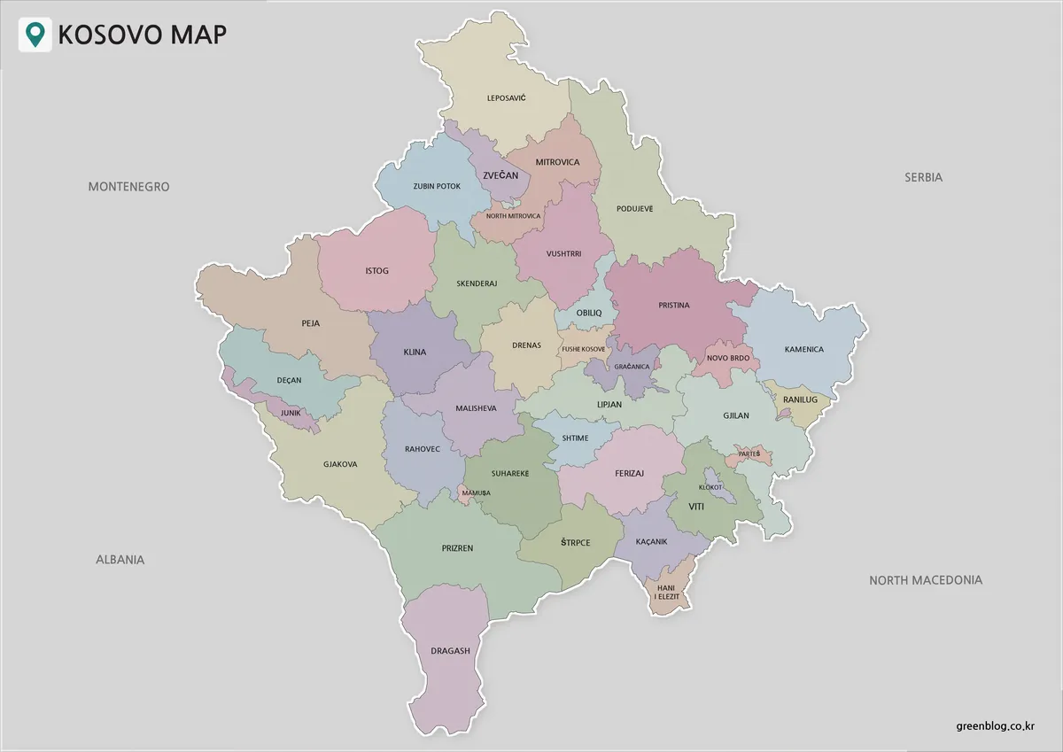
The color Kosovo map assigns a different muted tone to adjacent municipalities, making borders easier to distinguish at a glance. It is especially useful for presentations, educational displays, regional planning notes, and visual comparisons. The colors are categorical rather than political: they separate neighboring units and do not represent population, language, voting results, elevation, or any other statistical value.
All pieces belonging to one municipality should share one fill. This rule is important for detached polygons and small enclaves. Shashkoc therefore matches Pristina’s color, while the surrounding Gračanica and Lipjan areas retain their own colors. No gray wedge, open gap, or straight connector line should extend from a neighboring-country shape into Kosovo’s administrative area.
Blank outline version
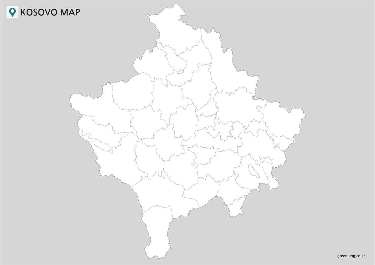
The Kosovo map outline removes municipality names but keeps both the national silhouette and the internal municipal borders. It provides a flexible base for quizzes, classroom worksheets, project annotations, custom legends, and original color palettes. Users can add capitals, transportation routes, statistics, or numbered regions without first removing existing labels.
The outline is also the best version for checking geometry. Shared borders should meet once, without doubled strokes, breaks, overlaps, or triangular fill artifacts. The outer national boundary should remain continuous, and neighboring-country background shapes should close outside that boundary. These construction rules help every external region accept a fill without spilling into Kosovo.
How to choose the right version
Use the black and white file when legibility and economical printing are the priorities. Choose the color file when the audience needs to distinguish municipalities quickly. Select the outline file when students, editors, or designers will add their own information. For slides, keep enough contrast between the white or colored country area and the gray surroundings; for print, use the A3 layout or scale it proportionally without stretching the map.
Before publishing an edited version, check the national border near narrow or fragmented municipalities, confirm that all detached pieces use their parent municipality’s fill, and verify that no decorative line crosses administrative polygons. This short review prevents the most common problems: double outlines, unclosed neighboring areas, incomplete color fills, and accidental wedges extending across the page.
FAQ
How many municipalities are shown on the Kosovo map?
The map shows 38 municipalities. Each version uses the same administrative structure, although the outline version intentionally omits the text labels.
Why is there a tiny detached shape near Gračanica?
That shape represents Shashkoc, an exclave of Pristina Municipality. It is geographically separated from Pristina’s main area, so it looks isolated, but it should be labeled or colored as part of Pristina rather than Gračanica.
Which version is best for printing?
The black and white version is best for low-ink printing and handouts. The color version works well for displays, while the outline version is suitable for activities and custom editing. All three are arranged for proportional A3 output.
Do the municipality colors represent data?
No. The pastel colors only help separate neighboring municipalities. They do not encode demographic, political, economic, linguistic, or geographic measurements.
Can I add my own labels to the outline version?
Yes. The unlabeled outline is intended as a clean base for lessons, presentations, annotations, and graphic projects. Keep the original proportions when resizing so that the municipal boundaries are not distorted.
Map File Information
This download includes printable Kosovo map versions for educational use, presentation design, document printing, and editable graphic projects.
- Included styles: Black and white, color, and outline
- Administrative coverage: 38 municipalities
- Page layout: A3 landscape
- File type: Image files
Related Maps
Additional Resources
- For practical destination ideas, cultural highlights, and regional travel information, visit the Kosovo Tourism Union.
Green Map creates custom-edited map images using open geographic data sources such as geoBoundaries, Natural Earth, OpenStreetMap, and government open data.
These maps are edited visual materials, not raw data files, and are provided for education, documents, presentations, and graphic reference.