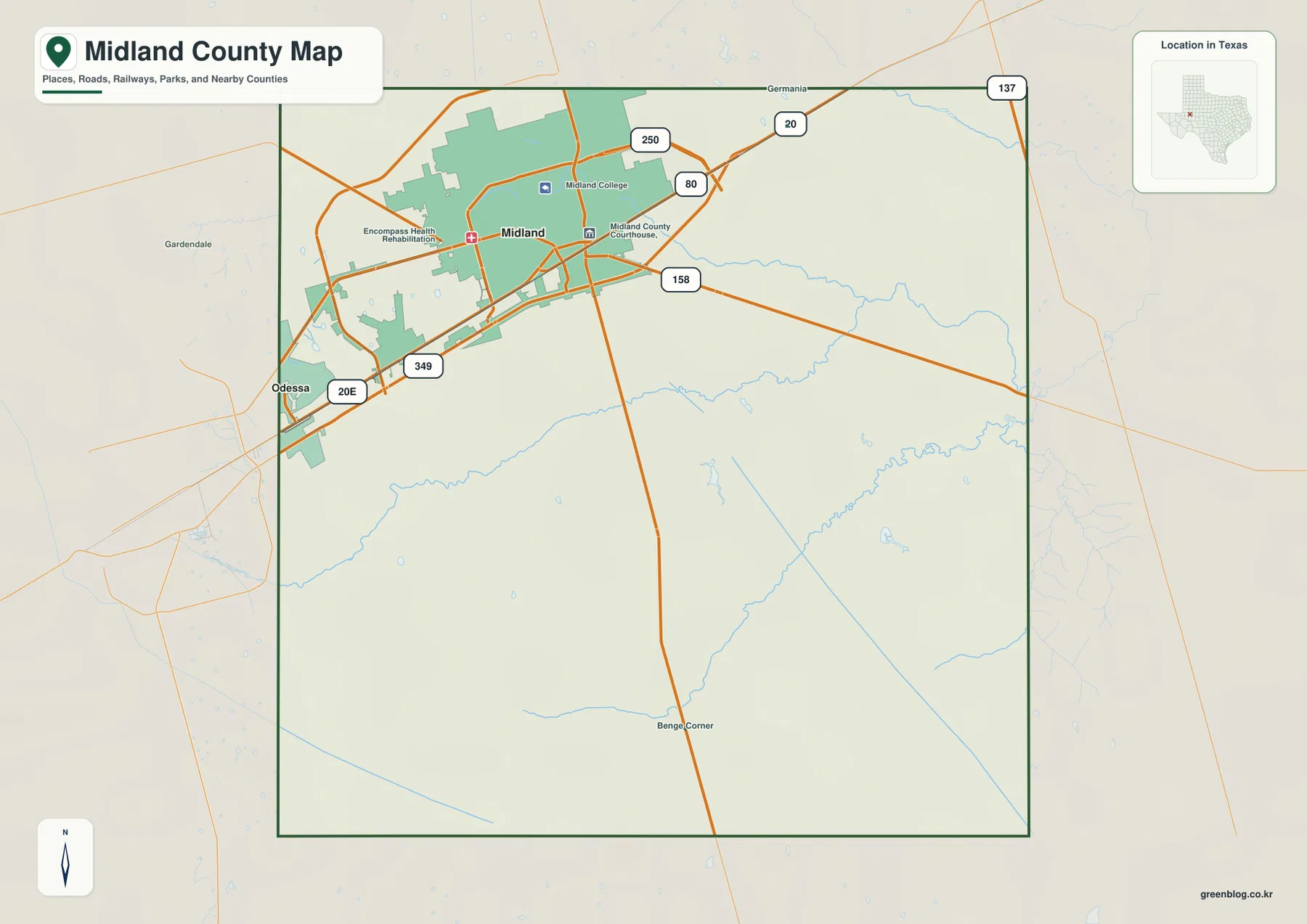
You can download four high-resolution A3 JPG maps of Midland County, Texas, in one ZIP directly from this page. The package includes a general county map, a ranked city map, a terrain-and-water map, and an elevation map. Together they show Midland, roads labeled 20E, 349, 158, 80, 250, 20, and 137, named draws and drainage channels, several small lakes, and an actual elevation range of about 777 to 909 meters.
Midland is the easiest place to begin because the developed area fills much of the county’s northwest corner, while the south and east are far more open. Roads 20E and 349 help locate the western and southwestern side of the city, Route 158 extends eastward, and roads 80 and 250 provide additional northern references. Once the road pattern is familiar, the water and elevation maps reveal a second structure beneath it: Midland Draw and Monahans Draw cross lower terrain, while the county generally drops from higher ground in the west and southwest toward the east.
Table of Contents
Midland dominates the northwest corner and anchors the road network
The general county map gives Midland by far the largest developed footprint. Midland College, the Midland County Courthouse, and a health facility are labeled inside or near the urban area, providing useful reference points within the city. Odessa appears just beyond the western boundary, emphasizing how close the Midland urban area lies to the neighboring Ector County side.
Roads 20E and 349 are labeled on the southwest side of the urban area, while Route 158 extends eastward into the county interior. Route 250 crosses the northern portion of Midland, and Route 80 is visible toward the northeast. Farther east and northeast, roads 20 and 137 provide additional edge references. These routes make the northwest look highly connected compared with the large open southern interior.
Gardendale and Germania appear outside the county as regional orientation points, while Benge Corner is labeled near the southern interior. Moving south from Midland, settlement labels become sparse and the road network opens into broad spaces crossed by small blue drainage lines. This transition from urban northwest to open south and east is one of the clearest patterns on the general map.
The city index highlights Midland as the single ranked major city
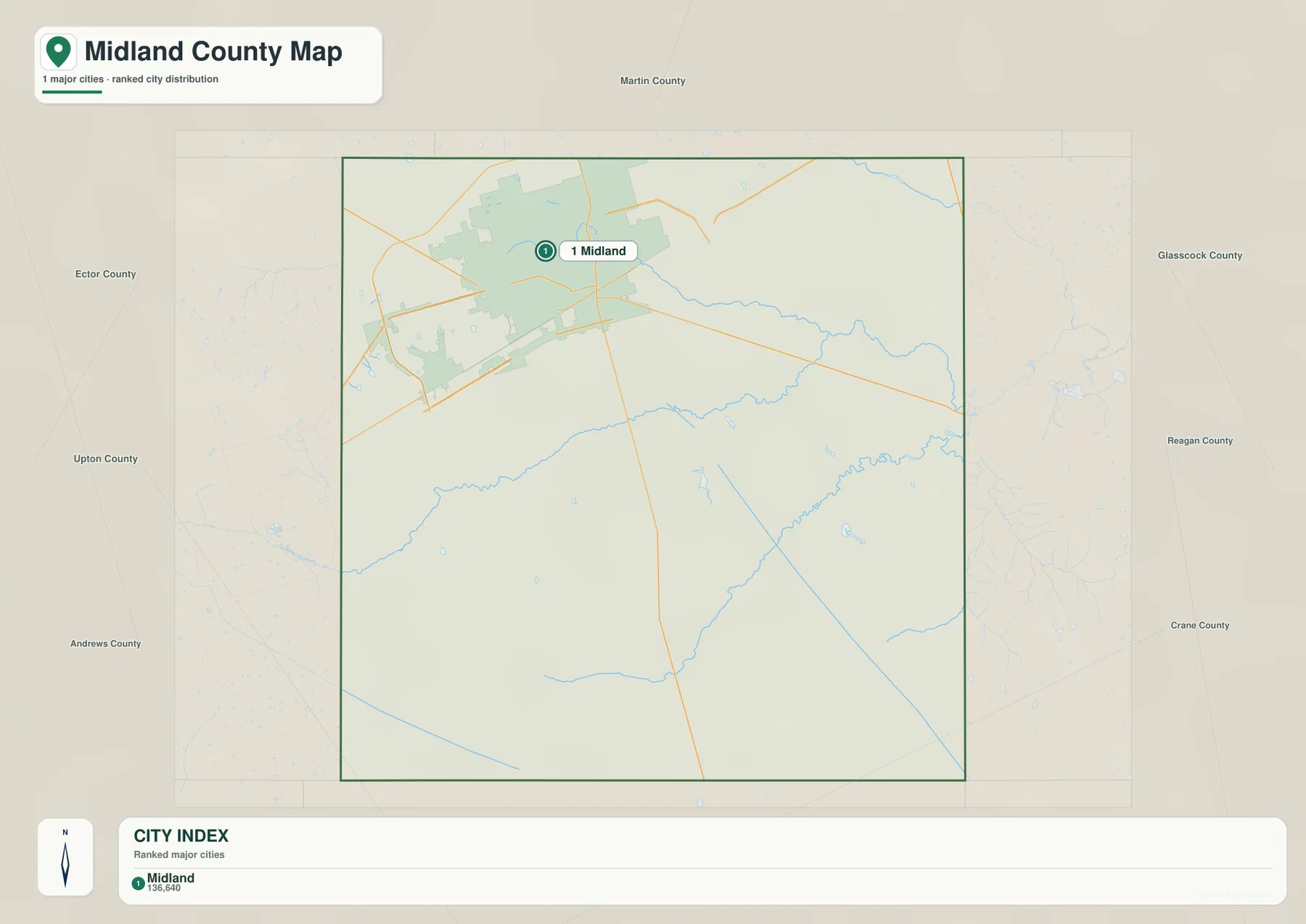
The ranked city map contains one major-city marker: Midland is number 1. The lower index also prints the value 136,640 beside the name. The supplied image does not identify a year for that number, so this article treats it only as a value shown on the map rather than presenting it as a confirmed current population count.
With most road and facility labels removed, Midland’s position becomes especially clear. The city occupies the northwest corner rather than the geographic center of the county, leaving a broad interior to the south and east. That open space is not featureless: the terrain-and-water layer shows several long draws, and the elevation view reveals a clear decline toward the eastern side.
Ector County is labeled to the west, Martin County to the north, Glasscock County to the east, Reagan and Crane counties to the southeast, and Upton and Andrews counties around the west and southwest. These surrounding names provide regional orientation. The city map is useful for locating Midland quickly, while the general map is better for road numbers and local references.
Midland Draw and Monahans Draw define the main interior drainage lines
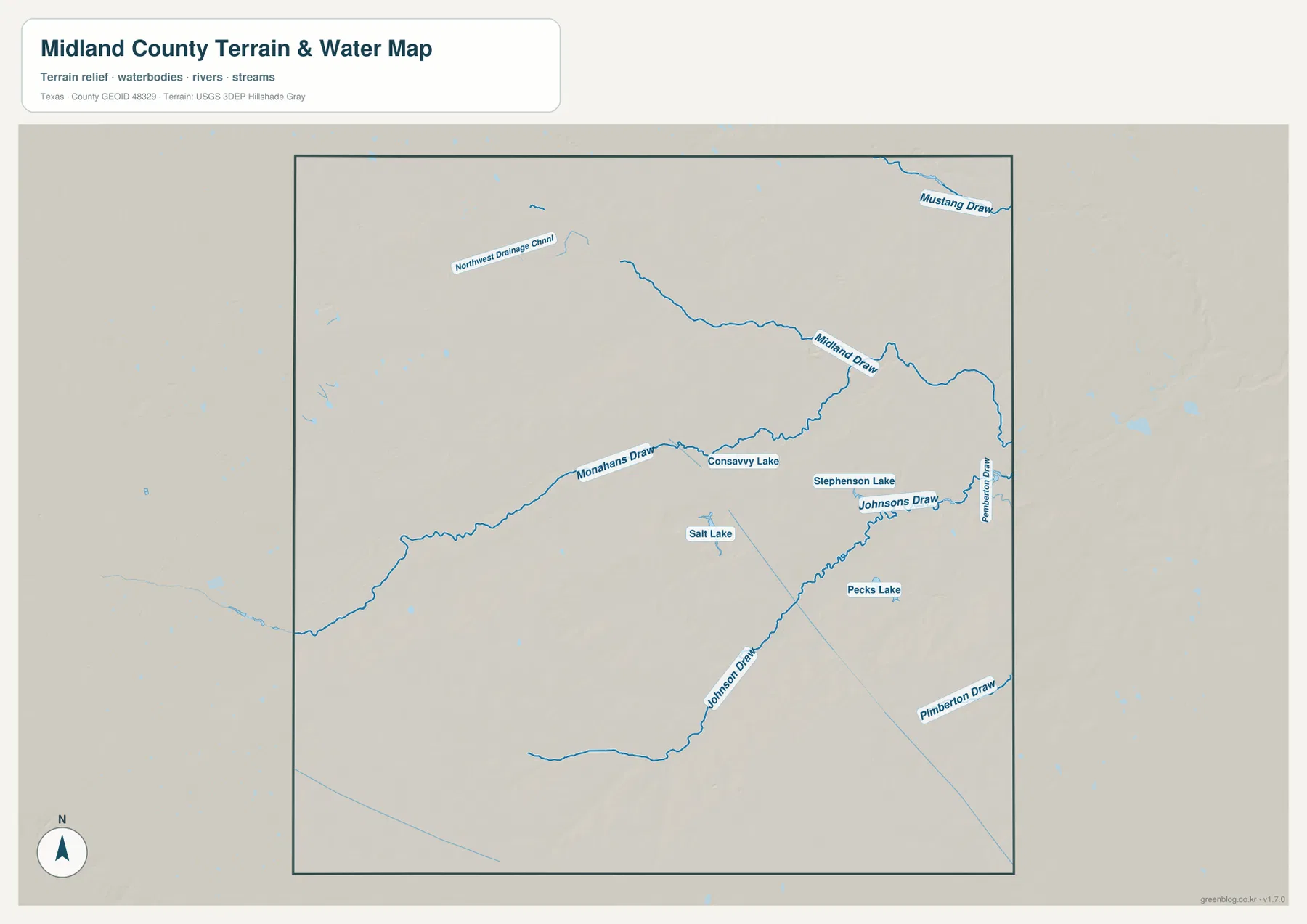
Midland Draw is one of the most prominent named water features on the terrain-and-water map. It crosses the north-central interior and bends toward the eastern boundary, with several smaller tributaries joining along the way. Matching the draw to the general map helps explain the lower drainage terrain east of the Midland urban area.
Monahans Draw enters from the west-central side and continues northeastward. Consavvy Lake and Stephenson Lake are labeled close to this drainage, providing useful small-water references along the same broad corridor. Salt Lake appears farther south, while Pecks Lake is located in the southeastern interior.
Johnsons Draw and other eastern channels mark the lower side of the county
Johnsons Draw follows a long course through the eastern half, while Pimberton Draw is labeled closer to the eastern edge. Mustang Draw appears near the northeastern corner, and Northwest Drainage Channel is labeled toward the upper-left side. In a county without a large named river on this map, these draws and channels are the most useful water references for locating low drainage corridors.
The supplied water layer also contains numerous small unnamed water marks and shorter drainage lines. This article does not assign names to features that are not labeled on the map. Focusing on the visible named draws, channel, and lakes keeps the written description tied to the actual supplied assets.
The terrain-and-water map is intended for geographic reference. It can help locate Midland Draw, Monahans Draw, Johnsons Draw, the small lakes, and other labeled channels relative to the county boundary, but it is not a flood-hazard map, legal water-boundary product, parcel map, or navigation chart.
Higher western ground descends toward lower eastern terrain
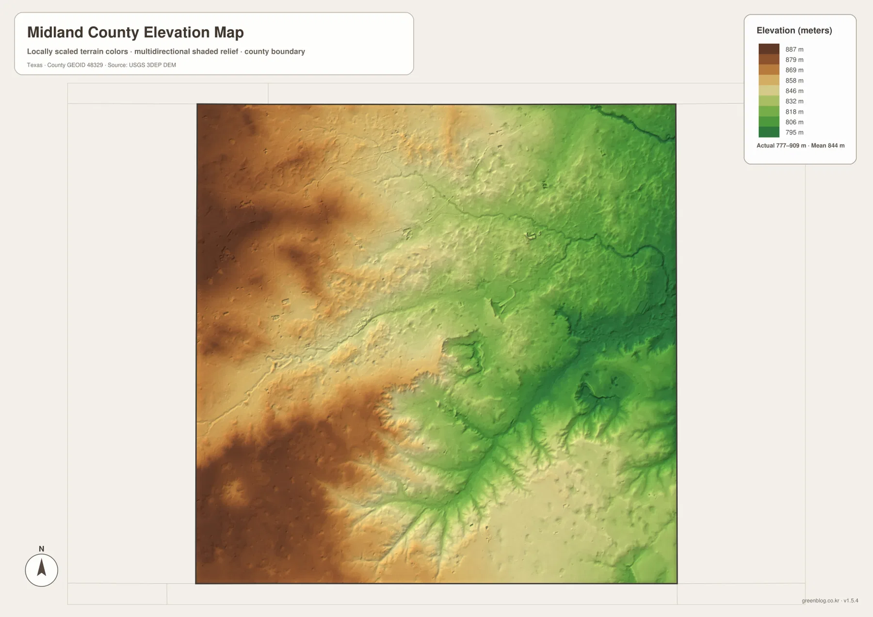
The elevation map reports an actual range of about 777 to 909 meters and a mean elevation of about 844 meters. The highest browns dominate the west and southwest, while colors shift through tan and yellow toward green across the east. The northeastern and eastern edges contain some of the lowest broad terrain on the map.
The west-to-east decline is not perfectly smooth. Midland Draw and Monahans Draw occupy narrow lower corridors, and additional drainage lines cut into the surrounding surface. The water and elevation maps line up clearly: the named draws follow many of the greener lower paths visible in the shaded relief.
The difference between the displayed minimum and maximum elevation is about 132 meters. That is not mountain-scale relief, but it is enough for the western high ground and eastern lowlands to appear distinctly different. Midland itself lies closer to the higher northwestern side, while much of the county interior drops gradually toward the east.
The elevation layer is best used for relative terrain comparison rather than survey-grade or engineering-grade measurement. Its main value here is to connect Midland, the named draws, and the broad west-to-east change in height into one physical view.
Following the map east from Midland connects roads, draws, and relief
Start at Midland on the general map and follow the road network east along the Route 158 and Route 80 directions. Urban development quickly gives way to a more open county interior. On the terrain-and-water map, Midland Draw becomes the main reference through the same broad area, and the elevation map shifts from tan higher terrain toward green lower ground.
The southwest provides the opposite comparison. Roads 20E and 349 sit near the Odessa side, Monahans Draw extends toward the middle, and the elevation layer shows the west and southwest with some of the county’s highest colors. This combination of city edge, draw, and high ground gives a more specific picture of Midland County than relying only on the broad Permian Basin label used in the older title.
Use the ranked city map when Midland’s position is the main question, the general map for road numbers and facilities, the terrain-and-water map for named draws and small lakes, and the elevation map for the high-west/low-east contrast. Small labels are often easier to inspect in the downloadable high-resolution JPG files than in the browser previews.
Frequently Asked Questions
Which city is highlighted on the Midland County city map?
Midland is the single ranked major city on the supplied city map. It occupies the northwest part of the county and is easy to locate on the general map near roads 20E, 349, 158, 80, and 250. The city index also prints 136,640, but no year is shown, so this article does not present that value as a confirmed current population count.
Which named drainage features are easiest to identify?
Midland Draw and Monahans Draw are the strongest interior references. Johnsons Draw and Pimberton Draw are on the eastern side, Mustang Draw appears in the northeast, and Consavvy Lake, Stephenson Lake, Salt Lake, and Pecks Lake are also labeled.
What elevation range is shown for Midland County?
The supplied elevation map reports an actual range of about 777 to 909 meters and a mean elevation of about 844 meters. The west and southwest are generally higher, while the eastern side and several draw corridors occupy lower terrain.
Sources and Reference Data
- U.S. Census Bureau TIGER/Line Shapefiles — official county-boundary and road geometry for geographic reference.
- USGS National Hydrography — official resources for draws, channels, lakes, and other water features.
- USGS 3D Elevation Program — official elevation resources used for terrain information.
- USGS The National Map Viewer — an official viewer for comparing geographic layers.
Map File Information
Download four high-resolution A3 JPG maps of Midland County, Texas, in one ZIP file.
- Included Files: county map, ranked city map, terrain and water map, elevation map
- File Type: JPG
Related Maps
- Andrews County Texas map
- Upton County Texas map
- Ward County Texas map
- Winkler County Texas map
- Reagan County Texas map
Green Map creates custom-edited map images using open geographic data sources such as geoBoundaries, Natural Earth, OpenStreetMap, and government open data. These maps are edited visual materials, not raw data files, and are provided for education, documents, presentations, and graphic reference.