Pasco County Map resources are especially useful because this Florida county does not have one single urban center that explains the whole area. The Gulf side contains New Port Richey, Port Richey, Hudson, and other developed communities, while Dade City and Zephyrhills sit far inland to the east. Between them are Land O’ Lakes, Wesley Chapel, major north-south highways, broad conservation areas, and numerous creeks and lakes.
Three map views compare different parts of Pasco County: a county reference map with roads and place names, a city map for the six incorporated municipalities, and a terrain-and-water map showing major rivers, streams, coastal water, and relief. A3 high-resolution JPG versions of all three maps are available together in one ZIP for printing, classroom materials, presentations, and local reference.
The most important thing to notice is the separation between the Gulf coast, the central suburban belt, and eastern Pasco. Dade City is the county seat, but it is not positioned near the large western population cluster. New Port Richey is near the Gulf and the lower Pithlachascotee River, Wesley Chapel is oriented toward I-75, and Dade City is tied more closely to U.S. 301 and State Road 52. Reading the roads and waterways together gives a much clearer picture than using place names alone.
Table of Contents
From the Gulf shoreline to Dade City and eastern Pasco
The county reference map shows the overall shape of Pasco County and the settlement pattern within it. The western edge is an irregular Gulf shoreline, not a straight boundary. Hudson, Port Richey, and New Port Richey are concentrated near that coast. Land O’ Lakes and Wesley Chapel appear farther inland across the southern half, while San Antonio, Dade City, and Zephyrhills form a distinctly eastern group. This east-west separation is one of the clearest geographic facts visible on the map.
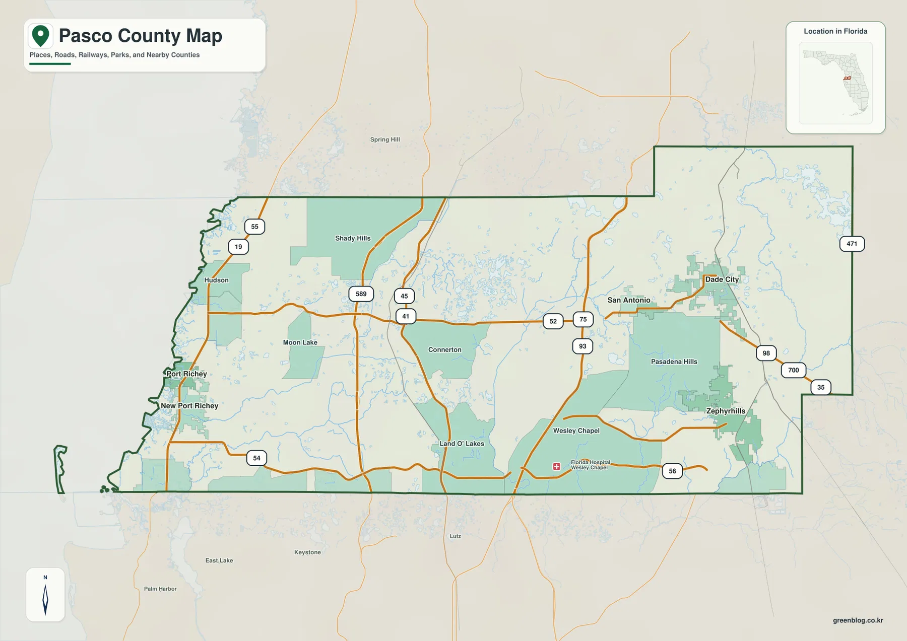
The road network explains why these places function as separate bands. U.S. 19 follows the western developed corridor near Hudson, Port Richey, and New Port Richey. State Road 589, the Suncoast Parkway, runs through the west-central interior. U.S. 41 gives Land O’ Lakes a north-south reference line, I-75 passes close to Wesley Chapel, and U.S. 301 connects the eastern side through Zephyrhills and Dade City. State Roads 52, 54, and 56 provide important east-west connections among those north-south routes.
The map also labels communities that are not incorporated municipalities. Shady Hills and Moon Lake appear in western and north-central Pasco, Connerton and Land O’ Lakes sit in the center-south, and Wesley Chapel is farther east near I-75. Pasadena Hills is between the Wesley Chapel and Dade City–Zephyrhills areas. These familiar community names appear alongside the six legal municipalities, but the labels do not represent incorporated city boundaries.
Dade City is the county seat, while much of the dense Gulf-side settlement lies many miles to the west and the fast-growing central suburban corridor lies farther south. The county map places administrative location, road access, and the spread of named communities in the same geographic frame.
Where Pasco County’s six incorporated cities are located
The city map removes most of the smaller community labels and emphasizes the six incorporated municipalities: Zephyrhills, New Port Richey, Dade City, Port Richey, St. Leo, and San Antonio. The result makes a pattern that is easy to miss on a general road map. Two cities sit close together on the Gulf side, while four are in the eastern half of the county, with Dade City, St. Leo, and San Antonio clustered relatively close to one another and Zephyrhills farther south.
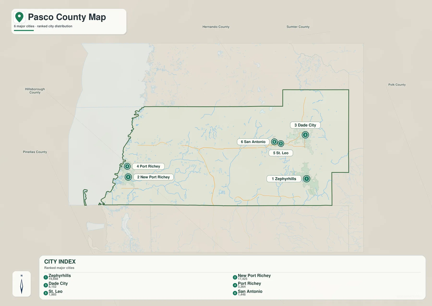
The ranked city index on the city map places Zephyrhills first and New Port Richey second, followed by Dade City, Port Richey, St. Leo, and San Antonio. The ranking also highlights a geographic contrast. The two larger incorporated cities are not side by side: Zephyrhills is in southeastern Pasco, while New Port Richey is on the western side near the Gulf. Dade City, the county seat, occupies the northeast rather than the center of the western urban belt.
Wesley Chapel does not appear in this six-city index even though it is one of the county’s best-known communities. It is a large census-designated community rather than an incorporated municipality. Land O’ Lakes is another major unincorporated community. The distinction separates commonly used place names from incorporated cities in school, local-government, and address references.
New Port Richey and Port Richey deserve special attention because their names are similar and their developed areas are close together. They are separate cities, with New Port Richey shown just south of Port Richey. On the other side of the county, Dade City and Zephyrhills are linked by the U.S. 301 corridor, while San Antonio and St. Leo sit to the west of Dade City. The city map is therefore most useful when the question is municipal location, not when the goal is to display every large community in Pasco County.
Rivers, creeks, and the low Gulf coast
The terrain-and-water map shifts attention away from roads and municipalities. It shows the Gulf of Mexico along the entire western side and highlights several named waterways that cross or border the county. The Pithlachascotee River reaches the New Port Richey area, the Anclote River and South Branch Anclote River lie farther south, Cypress Creek is labeled in the central part of the county, and New River appears in the southeast. The Withlacoochee River is visible near the northeastern side, along with numerous small lakes and ponds scattered across the interior.
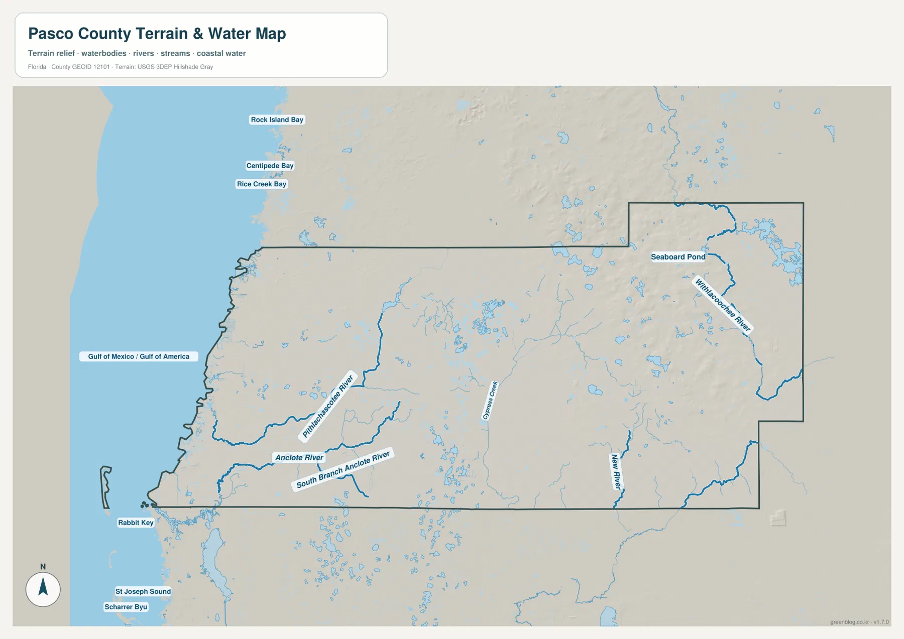
The shoreline is clearly different from a simple straight beach edge. Bays, tidal channels, offshore features, and low coastal land create an irregular western boundary. Rabbit Key is labeled near the southwest, and several bay names appear just outside the county to the northwest. These details help explain why the west side of Pasco looks so different from the straighter inland county lines. They also provide useful context for New Port Richey and Port Richey, where Gulf water and river mouths are close to the developed area.
The shaded relief also suggests a gradual change from very low coastal terrain toward somewhat more rolling inland ground around the eastern communities. It is a generalized reference surface, not survey-grade elevation data. The map is designed to show the relationship among landform, rivers, lakes, and the coast. It is not a flood-zone map, parcel map, legal boundary survey, or navigation chart. Property, insurance, engineering, and flood-risk information comes from separate current official datasets.
The Pithlachascotee River serves as a western geographic reference; official Southwest Florida Water Management District material identifies it as an important local river system reaching the Gulf through the New Port Richey area. The Anclote River system is farther south, while Cypress Creek and New River help orient the central and southeastern interior. The combined road and water context explains why a short straight-line separation between two communities does not always translate into a simple direct road connection.
Three geographic bands across Pasco County
The U.S. 19 Gulf-side communities
U.S. 19 forms the main north-south reference on the western side. Hudson lies north of Port Richey and New Port Richey, with the Gulf immediately to the west. The county reference map shows a relatively dense set of road and place labels in this band compared with the large interior spaces farther east. New Port Richey, Port Richey, Hudson, the developed coast, and nearby waterways appear across the county and terrain-and-water views together.
The SR 54 corridor through Land O’ Lakes and Wesley Chapel
Across the southern middle of Pasco, State Road 54 is a useful east-west reference. It connects the western side with Land O’ Lakes and the Wesley Chapel area while crossing major north-south routes such as the Suncoast Parkway, U.S. 41, and I-75. Wesley Chapel lies near I-75 and the SR 54/SR 56 corridor. This part of the county contains large communities that are prominent in everyday local geography even though they do not appear on the six-city municipal index.
Dade City, Zephyrhills, and the eastern interior
Eastern Pasco has a different visual character. Dade City is in the northeast, Zephyrhills is farther south, and U.S. 301 is the main road reference connecting their general area. San Antonio and St. Leo are positioned west of Dade City. The water map also shows more inland lakes and the northeastern Withlacoochee River area, rather than the immediate Gulf setting seen around New Port Richey. This contrast divides Pasco County into several connected geographic zones rather than one uniform suburban block.
Differences among the three Pasco County map views
The county reference map provides the broadest view of boundaries, roads, and named communities. Hudson, New Port Richey, Land O’ Lakes, Wesley Chapel, Dade City, and Zephyrhills appear together in this view. The city map isolates incorporated municipal status, while the terrain-and-water map emphasizes rivers, creeks, the Gulf shoreline, inland water, and generalized relief.
The three map views show complementary information. New Port Richey appears along U.S. 19 and near the Pithlachascotee River; Wesley Chapel lies near I-75 and the SR 54/SR 56 area; Dade City is associated with U.S. 301 and SR 52. The county map emphasizes overall location, the city map emphasizes municipal status, and the terrain-and-water map emphasizes physical geography.
The county map provides the broad reference view, while the city and terrain-and-water maps add municipal and physical-geography detail. Parcel boundaries, zoning districts, flood insurance zones, and turn-by-turn routing are separate datasets and are not included in these files.
Frequently Asked Questions
Why is Wesley Chapel not one of the six cities on the city map?
Wesley Chapel is a large and widely used community name, but it is not an incorporated municipality. That is why it appears on the broader county map but not on the six-city index, which is limited to Zephyrhills, New Port Richey, Dade City, Port Richey, St. Leo, and San Antonio.
Are New Port Richey and Port Richey the same city?
No. They are neighboring but separate incorporated cities on the western side of Pasco County. The city map places New Port Richey just south of Port Richey. The city map shows New Port Richey and Port Richey as separate neighboring municipalities despite their similar names and adjacent developed areas.
Does the terrain-and-water map show flood risk?
No. It is a geographic reference showing rivers, streams, coastal water, inland water, and generalized relief. It is not a FEMA flood map or a property-specific risk product. Flood and parcel information for insurance, building, and property matters is maintained separately by the responsible agencies.
Map File Information
The ZIP contains three Pasco County A3 high-resolution JPG files: the county map, city map, and terrain/water map.
- Included Files: county map, city map, and terrain/water map
- Printable Size: 3638 × 2572 pixels each
- File Type: ZIP containing three high-resolution JPG files
Related Maps
- Arcadia Roads and Peace River | DeSoto County Florida Map
- Baker County Florida Map
- Between the Aucilla and Withlacoochee: Madison County Florida Map
Sources and References
- U.S. Census Bureau: Pasco County QuickFacts
- Pasco County GIS municipal boundaries
- Florida Department of Transportation county highway maps
- Southwest Florida Water Management District: Pithlachascotee River
- Southwest Florida Water Management District: Starkey Wilderness Preserve
- Florida State Parks: Anclote Key Preserve
Green Map creates custom-edited map images using open geographic data sources such as geoBoundaries, Natural Earth, OpenStreetMap, and government open data. These maps are edited visual materials, not raw data files, and are provided for education, documents, presentations, and graphic reference.